Browse Listings in America
![[The battle between rival indians near Bertioga].](/uploads/cache/39414-250x250.jpg)
[The battle between rival indians near Bertioga].
An epic struggle between theTupinambá tribe and their enemy - the Tupiniki tribe.The battle lasted about two hours, during which time both sides howled at each other lik...
Place & Date: Frankfurt, 1607
Selling price: $150
Sold in 2018
![[A Portuguese ship comes to look for Staden].](/uploads/cache/39416-250x250.jpg)
[A Portuguese ship comes to look for Staden].
Hans Staden was a German soldier and explorer, who travelled to South America during the mid 16th century. Whilst there he was captured by native Indians in Brazil. He su...
Place & Date: Frankfurt, 1607
Selling price: $130
Sold in 2018
![[Native Virginian women sitting around a fire].](/uploads/cache/39419-250x250.jpg)
[Native Virginian women sitting around a fire].
A print of (mostly) native Virginian women sitting around a large campfire, one with plenty of flame and smoke.Theodore De Bry (1528-1598), was born in Liege in modern da...
Place & Date: Frankfurt, 1607
Selling price: $130
Sold in 2018
![[The town of Pomeiock].](/uploads/cache/39420-250x250.jpg)
[The town of Pomeiock].
Pomeiock was a village with a strong palisade all round, and a very narrow entrance, which was typical of that region.
Place & Date: Frankfurt, 1607
Selling price: $400
Sold in 2017
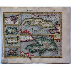
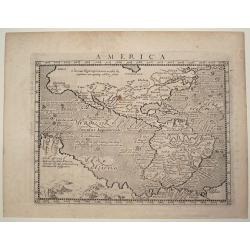
Cuba.
An attractive copper engraved map of Cuba & the Caribbean islands from Mercator's "Atlas Minor", with larger images of Cuba and Hispaniola, and four smaller...
Place & Date: Amsterdam, 1607
Selling price: $85
Sold in 2017
![[The town of Pomeiock].](/uploads/cache/42276-250x250.jpg)
[The town of Pomeiock].
Pomeiock was a village with a strong palisade all round, and a very narrow entrance, which was typical of that region. Inside were a few houses in which only the chief an...
Place & Date: Frankfurt, 1607
Selling price: $400
Sold in 2018
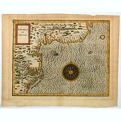
Norumbega et Virginia.
An important map that shows the east coast of North America from the Outer Banks of present day Carolina and on up to Canada. Chesapeake Bay is called "Chesipooc Sin...
Place & Date: Douai, 1607
Selling price: $2050
Sold in 2020
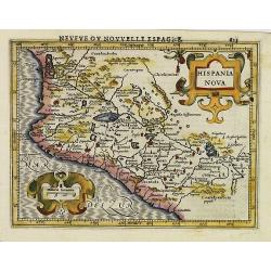
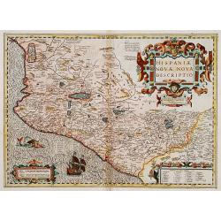
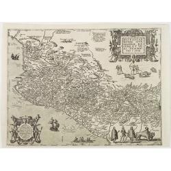
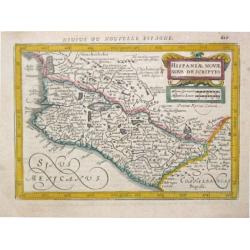
Hispania Nova.
This was the standard map of the Mexico for a generation. The map shows an area corresponding roughly to the modern Mexican states of Michoacan, Jalisco, Mayarit, and Gue...
Place & Date: Amsterdam, 1608
Selling price: $350
Sold
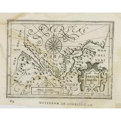
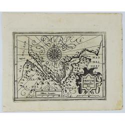
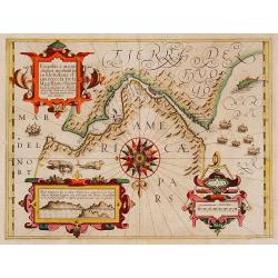
Fretum Magella:ni.
Early map of Strait Magellan. Depicts the extremity of South America, with Patagonia, the Straight of Magellan, Terra del Fuego and the discoveries made by LeMaire and Sc...
Place & Date: Amsterdam, 1608
Selling price: $100
Sold in 2008
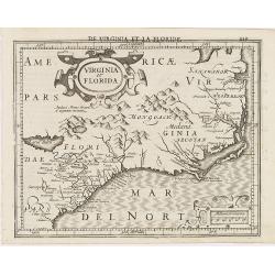
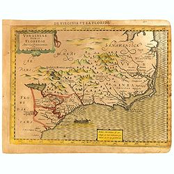
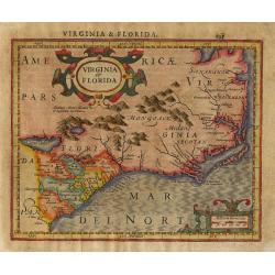
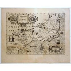
Virginia et Florida.
Excellent example of Mercator's miniature map of Colonial America, south to named St. Augustine, north past Chesapeake Bay. Early reference to 'Apalacci' Mountains, showi...
Place & Date: Amsterdam, 1608
Selling price: $500
Sold in 2013
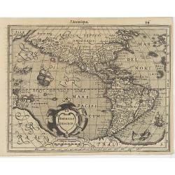
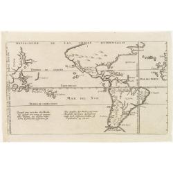
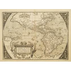
Americae Descrip.
Map of America from the first French-text edition of Jodocus Hondius' Atlas Minor.Shortly after the publication of the big folio-atlases the need was apparently felt for ...
Place & Date: Amsterdam, 1608
Selling price: $350
Sold in 2016

Polus Arcticus cum vicinis regionibus.
Map of the North Pole regions from the 1608 second edition of Jodocus Hondius' Atlas Minor.A reduction of the 1606 Mercator-Hondius folio map (which is a later state of t...
Place & Date: Amsterdam, 1608
Selling price: $500
Sold in 2012
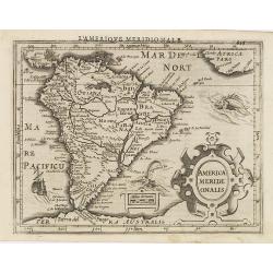
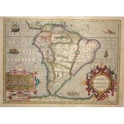
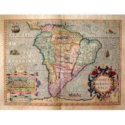
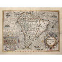
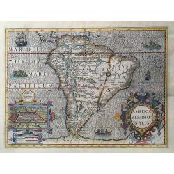
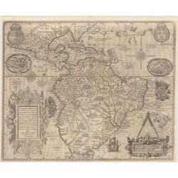
America Meridi:onalis.
Attractive map of South America, embellished with a strapwork title-cartouche, from the first French-text edition of Jodocus Hondius' Atlas Minor.Shortly after the public...
Place & Date: Amsterdam, 1608
Selling price: $200
Sold in 2009
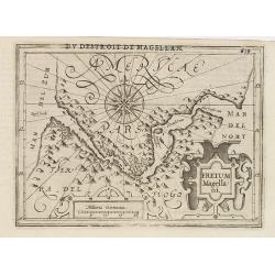
Fretum Magellani.
Early map of Strait Magellan. Depicts the extremity of South America, with Patagonia, the Straight of Magellan, Terra del Fuego and the discoveries made by LeMaire and Sc...
Place & Date: Amsterdam, 1608
Selling price: $150
Sold in 2011
Virginiae Item et Floridae Americae Provinciarum.nova Descriptio.
An attractive, detailed and early map of the Southeast from the rare Cloppenburg edition slightly larger format and more scarce edition of the Mercator/Hondius "Atla...
Place & Date: Amsterdam, Cloppenburgh, 1608
Selling price: $300
Sold in 2016
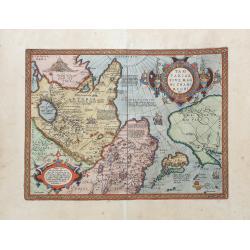
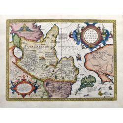
Tartariae sive magni regni...
An attractive old color example of this important map of Tartary, Japan, and the west coast of North America, from Ortelius' Theatrum Orbis Terarrum, the first modern at...
Place & Date: Amsterdam, 1608
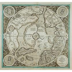
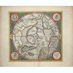
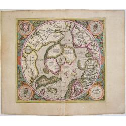
SEPTENTRIONALIUM Terrarum descriptio. Per Gerardum Mercatore
State 2. This is the first map devoted to the Arctic, a hemispherical one on a North Polar projection with an attractive floral design surrounding it. In the corners are ...
Place & Date: Amsterdam 1609
Selling price: $1325
Sold
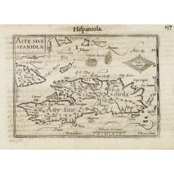
Aity Sive Spaniola.
General map of Hispaniola. Title cartouche on the upper left corner.First published in 1598 in his Caert-Thresoor, the plates were executed by the most famous engravers i...
Place & Date: Amsterdam/Frankfurt 1609
Selling price: $160
Sold
Virginia et Florida
Nice small map based on the Hondius' folio map of the same name. Based on John White's Virginia and Jacques le Moyne's Florida as interpreted by Theodore de Bry. Numerous...
Place & Date: Amsterdam, 1609
Selling price: $300
Sold in 2011
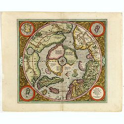
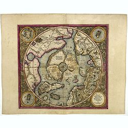
SEPTENTRIONALIUM Terrarum descriptio. Per Gerardum Mercatore.
State 2. This is the first map devoted to the Arctic, a hemispherical one on a North Polar projection with an attractive floral design surrounding it. In the corners are ...
Place & Date: Amsterdam, 1609
Selling price: $2450
Sold in 2013
Septentrionalium Terrarum descriptio. Per Gerardum Mercatorem Cum Privilegio.
State 2. This is the first map devoted to the Arctic, a hemispherical one on a North Polar projection with an attractive floral design surrounding it. In the corners are ...
Place & Date: Amsterdam, 1609
Selling price: $2000
Sold in 2015
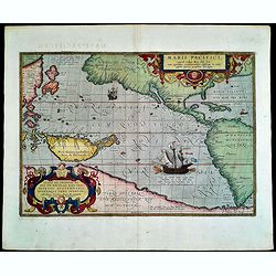
Maris Pacifici.
Splendid map by Ortelius.This was the first printed map to be devoted solely to the Pacific, and the first to name North and South America separately. It includes most of...
Place & Date: Antwerp, 1609
Selling price: $6190
Sold in 2015
Fretum Magellani.
An early map of Strait Magellan. Depicts the extremity of South America, with Patagonia, the Straight of Magellan, Terra del Fuego and the discoveries made by LeMaire and...
Place & Date: Amsterdam, 1609
Selling price: $180
Sold in 2020
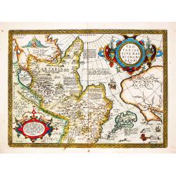
Tartariae sive Magni Chami Regni typus.
The famous and important map of Tartary, Japan, and the west coast of North America, from Ortelius' Theatrum Orbis Terarrum, the first modern atlas of the World.This map ...
Place & Date: Antwerp, 1609
Selling price: $959
Sold in 2020
Tartariae sive Magni Chami Regni Typus.
Tartariae sive Magni Chami Regni Typus. Map of Mongolia, also showing the northwest coast of North America. Abraham Ortelius(1527-98), Dutch cartographer and publishe...
Place & Date: Antwerp, Robert Bruneau, 1609
Selling price: $500
Sold in 2021
-250x250.jpg)
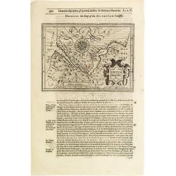
Hispaniolae, Cubae Alliarumique Insularium
Abraham Ortelius (1527-98), Dutch cartographer and publisher of the first modern atlas, ' Theatrum Orbis Terrarum' in 1570. Editions till 1612. Also an atlas of ancient c...
Place & Date: Antwerp, 1609
Selling price: $250
Sold in 2022
Americae Descrip.
Verso Latin text. An intricate and beautiful map of North and South America as well as parts of the Atlantic and Pacific Ocean.
Place & Date: Amsterdam, ca. 1610
Selling price: $600
Sold in 2013
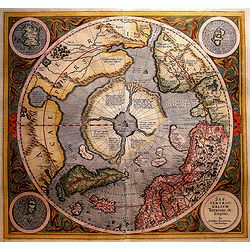
Septentrionalium Terrarum descriptio
This influential map was the first separately printed map devoted to the Arctic. The hemisphere is surrounded by a floral design with four roundels in each corner. These ...
Place & Date: Amsterdam, 1611
Selling price: $1150
Sold in 2011
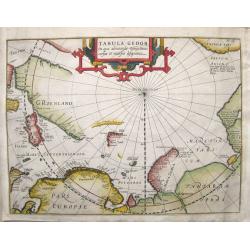
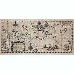
Tabula Geogr. in qua admirandae navigationis cursus et recursus designatur.
First state of a very early and scarce map of the North Pole and Arctic regions showing recent discoveries including the voyage of Jan Willem Barentsz on his quest to fin...
Place & Date: Amsterdam, 1611
Selling price: $850
Sold in 2016
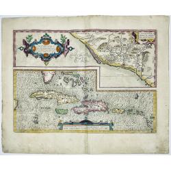
CULIACANAE,A MERICAE REGIO NIS, DESCRIPTIO - Hispaniolae, Cubae, Aliarumique Insularum Circumiacientium Delineatio
CULIACANAE, A MERICAE REGIO NIS, DESCRIPTIO - Hispaniolae, Cubae, Aliarumique Insularum Circumiacientium Delineatio.Antique map of the Caribbean. Two maps on one sheet: ...
Place & Date: Antwerp, 1603-1612
Selling price: $400
Sold in 2023

Tartariae sive Magni Chami Imperium.
This is a very early depiction of the northern Pacific, with the first mapping of Northwest Coast of America and probably the first map to name California 'C. Califormio...
- $2500 / ≈ €2339
Place & Date: Antwerp, c. 1608-1612
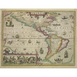
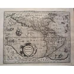
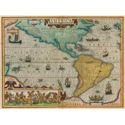
America.
A very nice map from America, first published in 1606 and used till 1630. This example published in 1613, one year after the death of Jodocus Hondius I. The inset shows n...
Place & Date: Amsterdam, 1606 - 1613
Selling price: $3650
Sold in 2009
Tabula Nautica, qua repraesentantur orae maritimae.
First map to depict Hudson bay, prepared by Hessel Gerritsz, and reduced and included by de Bry in his tenth part of his Petit Voyages .Hudson had already made three acco...
Place & Date: Frankfurt, 1613
Selling price: $2600
Sold in 2012
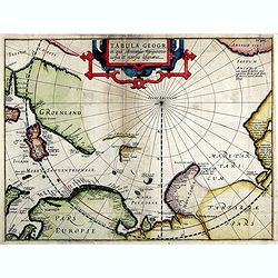
Tabula Geogr. In qua admirandae navigatonis..
A finely engraved map by Jodocus Hondius with coastline details of northern Europe, Greenland, Frisland, Strait Anian with America pars. With the track of a Willem Barent...
Place & Date: Amsterdam, 1614
Selling price: $740
Sold in 2019
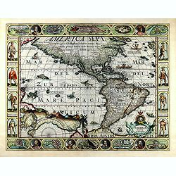
AMERICAE NOVA DESCRIPTIO
FIRST State of Pieter Van Den Keere's rare Carte a figures of America -- The First Single Sheet Map of America to include decorative panels. This first state (of six) of ...
Place & Date: Amsterdam, 1614
Selling price: $6700
Sold in 2019
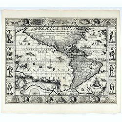
Americae Nova Descriptio
FIRST State of Pieter Van Den Keere's rare Carte a figures of America -- The First Single Sheet Map of America to include decorative panels. This first state (of six) of ...
Place & Date: Amsterdam, 1614
Selling price: $10000
Sold
America Meridionalis.
Superb folio map of the continent that was added by Jodocus Hondius for publication in his continuation of the Mercator Atlas. The map is beautifully engraved with a wave...
Place & Date: Amsterdam 1609/1616
Selling price: $900
Sold
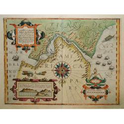
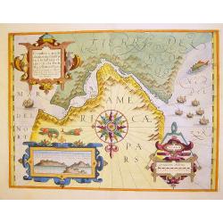
Tierra del Fuogo / Porto Desire (Carte vande nieuwe Passagie bezuijden de Strate Magellan)
Early map of the region depicting the tip of South America with Tierra del Fuogo, which is unexplored on the west. Depicts the tract of Guillaume Schouten and Jacob Le Ma...
Place & Date: Cologne, c. 1616
Selling price: $450
Sold in 2011
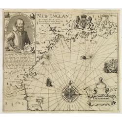
New England/ Die mercklichsten dheile. .
Hulsius used the first state of Smith's New England map published the previous year in London. The most noticeable differences, however, are the lack of any imprints lowe...
Place & Date: Frankfurt ,1617
Selling price: $8100
Sold in 2012
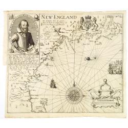
Die Mercklichsten Dheile, also Genennet durch den Durchl: und Mechtigen Prinzen und H.H. Carolus, Prinzen von Gross Britannien.
Hulsius used the first state of Smith's New England map published the previous year in London. The most noticeable differences, however, are the lack of any imprints lowe...
Place & Date: Frankfurt, 1617
Selling price: $10000
Sold
America.
Map of America from Magini's 'Geographiae Universae', printed by Petrus Keschedt, containing a completely new set of maps, derived from the earlier Italian edition. Accor...
Place & Date: Cologne, 1617
Selling price: $300
Sold in 2015
Hispaniae novae nova descriptio.
A map of Mexico, embellished with a large title cartouche, a sailing ship, and a sea monster.
Place & Date: Amsterdam 1619
Selling price: $200
Sold
Exquisita & magno aliquot.. Freti Magellanici..
Map of the extremities of South America. North at 180 degrees. Borders graduated for latitude. Single compass rose with radiates. Scale in German miles. Soundings and sho...
Place & Date: Amsterdam 1619
Selling price: $780
Sold
Descripcion de las Indias Ocidentalis.
De Bry's version of this important map by Antonio de Herrera y Tordesillas with cartography based on the manuscript charts of Juan Lopez de Velasco.It depicts the Papal l...
Place & Date: Frankfurt 1619
Selling price: $900
Sold
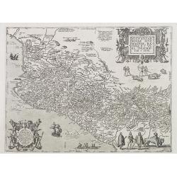
Hispaniae novae sive magnae, recens et vera descriptio * 1595.
This was the standard map of the area for a generation, copied after Ortelius. Both cartouches in the map are copies of designs by Hans Vredeman de Vries. The map shows a...
Place & Date: Frankfurt 1619
Selling price: $300
Sold
Hispaniae novae sive magnae, recens et vera descriptio * 1595.
This was the standard map of the area for a generation, copied after Ortelius. Both cartouches in the map are copies of designs by Hans Vredeman de Vries. The map shows a...
Place & Date: Frankfurt, 1619
Selling price: $1200
Sold
America
Jodocus Hondius's fine delineation of the Americas is probably the most attractive map of the Western Hemisphere in the Mercator/Hondius/Janssonius succession. A clarity ...
Place & Date: Amsterdam, 1619
Selling price: $3900
Sold in 2010
Exquisita & magno aliquot.. Freti Magellanici. . .
A map of the extremities of South America. North at 180 degrees. Borders graduated for latitude. Single compass rose with radiates. Scale in German miles. Soundings and s...
Place & Date: Amsterdam, 1619
Selling price: $1050
Sold in 2020
Americae sive Novi Orbis, nova descriptio.
Though it was generally believed that the production of Ortelius' maps ended with the 1612 edition, records in the Plantin Museum show that in 1628 the engravers Arsenius...
Place & Date: Antwerp, c.1620
Selling price: $8675
Sold
America Meridionalis
A stunning map of South America with Latin text on the verso. The Strait of Magellan is shown but Tierra Del Fuego is part of the large southern continent. Eastern Braz...
Place & Date: Amsterdam, c 1620
Selling price: $1200
Sold
HISPANIA NOVAE / NOVA DESCRIPTIO.
The Mercator / Hondius pocket atlas 'Atlas Minor' was published between 1607 and 1651, editions in Latin, Dutch English, French and German.A map of Mexico.
Place & Date: Amsterdam, c. 1620
Selling price: $120
Sold in 2019
America Meridionalis.
A very decorative map which includes several animated vignettes of ships, sea monsters and indigenous people. The inset is a view of Cuzco in Peru, the Inca capital. The ...
Place & Date: Amsterdam, 1620
Selling price: $1000
Sold in 2009
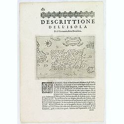
S.Giovanni. (Puerto Rico)
One of the earliest obtainable separate maps of Puerto Rico. Also shows the Virgin Islands, with a large St. Croix (Croce). Includes decorative cartouche, four sea monste...
Place & Date: Venice, 1620
Selling price: $300
Sold in 2013
America Meridionalis.
Gerard Mercator's stunning map of South America.The Strait of Magellan is shown, but Tierra Del Fuego is part of the large southern continent. Eastern Brazil is depicted ...
Place & Date: Amsterdam, ca. 1620
Selling price: $1200
Sold in 2016
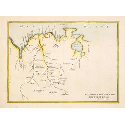
Descripcion del audiencia del nuevo Reino 9
Rare map of Venezuela from Novus Orbis, sive Descriptio Indiae Occidentalis. This collection of voyages is often referred to as an edition of Herrera, which is not strict...
Place & Date: Amsterdam 1622
Selling price: $200
Sold
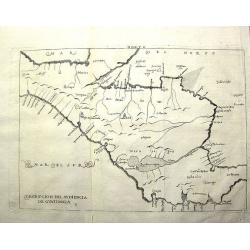
Descripcíon del Audiencía de Guatimala
Rare Spanish map with some place names along the coast, but scant internal detail, reflecting the official policy of protecting Spanish knowledge of the New World. This m...
Place & Date: Amsterdam, 1622
Selling price: $300
Sold in 2011
![[Title page] Description des Indes Occidentales Qu'on appelle aujourdhuy Le Nouveau Monde. . .](/uploads/cache/37040-250x250.jpg)
[Title page] Description des Indes Occidentales Qu'on appelle aujourdhuy Le Nouveau Monde. . .
Title page from Antonio de Herrera y Tordesillas Description des Indes Occidentales Qu'on appelle aujourdhuy Le Nouveau Monde. . . Herrera was the official historian of C...
Place & Date: Amsterdam, Michel Colin, 1622
Selling price: $850
Sold in 2017
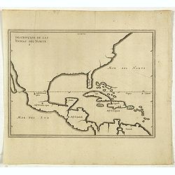
Descripcion De Las Yndias Del Norte.
Map of the Southern United States, Mexico, Central American and the Caribbean, from his Description des Indes Occidentales Qu'on appelle aujourdhuy Le Nouveau Monde. . fi...
Place & Date: Amsterdam, Michel Colin, 1622
Selling price: $700
Sold in 2017
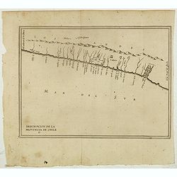
Descripcion De la Provincia de Chile. 13
Rare early map of the province of Chile, locating rivers and settlements, the earliest map to include information from the previously secret manuscript maps of the Spanis...
Place & Date: Amsterdam, Michel Colin, 1622
Selling price: $375
Sold in 2017
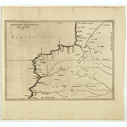
Descripcion Del Audiencia Del Quito. (Colombia & Ecuador)
Rare early map of now Ecuador and Quito. From Antonio de Herrera y Tordesillas Description des Indes Occidentales Qu'on appelle aujourdhuy Le Nouveau Monde. .. This map i...
Place & Date: Amsterdam, Michel Colin, 1622
Selling price: $450
Sold in 2017
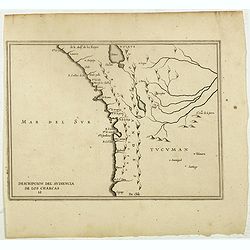
Descripcion Del Audiencia De los Charcas (Chile, Bolivia, Peru)
The earliest map to include information from the previously secret manuscript maps of the Spanish cosmographer, Juan López de Velasco, showing the Audiencia of the New K...
Place & Date: Amsterdam, Michel Colin, 1622
Selling price: $300
Sold in 2017
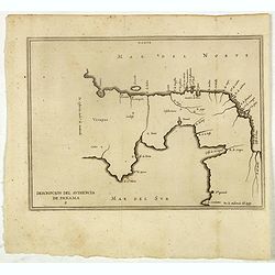
Descripcion del audiencia de Panama.
Rare early map of the Audiencia of Panama. The earliest map to include information from the previously secret manuscript maps of the Spanish cosmographer, Juan López de ...
Place & Date: Amsterdam, 1622
Selling price: $380
Sold in 2017
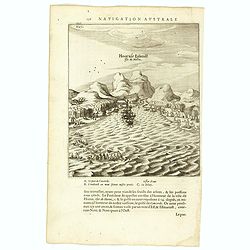
Hoornse Eijlandt Isle de Hoorn.
Scarce print on French text sheet showing the bay and coast of the South Seas island of Futuna (Hoorn). The bay shown was named after the ship Eendrachts (Unity Bay). Wil...
Place & Date: Amsterdam, 1622
Selling price: $250
Sold in 2018
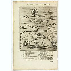
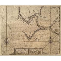
Untitled map of Port Desire (today's Puerto Deseado, Argentina)
Scarce untitled map of Port Desire (today’s Puerto Deseado, Argentina).From a description of the voyage of Le Maire and Schouten included in first French text edition o...
Place & Date: Amsterdam, 1622
Selling price: $400
Sold in 2018
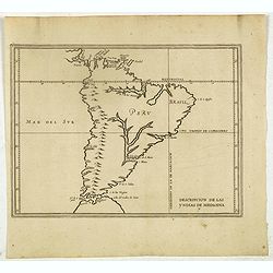
Descripcion de las Yndias de Mediodia. 7.
The earliest map to include information from the previously secret manuscript maps of the Spanish cosmographer, Juan López de Velasco, showing South America with the pap...
Place & Date: Amsterdam, Michel Colin, 1622
Selling price: $400
Sold in 2017
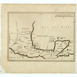
Descripcion del destricto del audiencia de nueva Espana 4.
Rare map of the southern part of Mexico. From Antonio de Herrera y Tordesillas Description des Indes Occidentales Qu'on appelle aujourdhuy Le Nouveau Monde. .. Herrera se...
Place & Date: Amsterdam, 1622
Selling price: $200
Sold in 2021
Exquilita.. Freti Magellanici Facies.
A highly decorative and sought after copperplate engraving of the Straights of Magellan from the Mercator-Hondius atlas. This example depicts creatures believed to inhabi...
Place & Date: Amsterdam 1623
Selling price: $750
Sold
SEPTENTRIONALIUM Terrarum descriptio. Per Gerardum Mercatore
State 2. This is the first map devoted to the Arctic, a hemispherical one on a North Polar projection with an attractive floral design surrounding it. In the corners are ...
Place & Date: Amsterdam, 1623
Selling price: $2100
Sold in 2016
SEPTENTRIONALIUM Terrarum descriptio. Per Gerardum Mercatore
State 2. This is the first map devoted to the Arctic, a hemispherical one on a North Polar projection with an attractive floral design surrounding it. In the corners are ...
Place & Date: Amsterdam, 1623
Selling price: $1500
Sold in 2019
![[Unmounted gores from a very rare Dutch Globe]](/uploads/cache/46309-250x250.jpg)
[Unmounted gores from a very rare Dutch Globe]
These rare gores are very possibly the only surviving examples from a 17 inch (44cm) diameter globe by Hondius and Janssonius. It is believed that only four of five examp...
Place & Date: Amsterdam, ca 1623
Selling price: $7600
Sold in 2020
Virginiae item et Floridae Americae provinciarum nova descriptio
"Virginiae item et Floridae Americae provinciarum nova descriptio" is a map created by Dutch cartographer Gerard Mercator and Jodocus Hondius in 1606. It is sig...
Place & Date: Amsterdam 1623
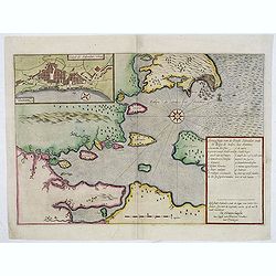
Aenwysinge van de Stadt Salvador, ende de Baya de Todos Los Santtos.
Extremely rare map of Salvador and Baia de Todos os Santos (Bay of Saints) published by the The Hague publisher Henricus Hondius (not to confuse with the Amsterdam H.Hond...
Place & Date: The Hague, 1624
Selling price: $2100
Sold
Americae Pars Magis Cognita.
A beautiful map focusing on the Spanish possessions in the Americas, this map covers what is the present-day southern United States through South America. It was publishe...
Place & Date: Low Countries, 1624
Selling price: $3800
Sold in 2019
Fretum Magellani.
The rare Samuel Purchas' edition of the Mercator/Hondius Atlas Minor atlas map. Early map of Strait Magellan. Depicts the extremity of South America, with Patagonia, the ...
Place & Date: London 1625
Selling price: $328
Sold
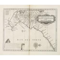
Provincia Sitæ Ad Fretum Magallanis itemque Fretum Le Maire.
Detailed map of the southern tip of South America, with coastline and Strait of Magellan from Tierra del Fuego to southern Argentina.Scarce map prepared by Hessel Gerrits...
Place & Date: Leiden, Elzevier, 1625
Selling price: $425
Sold in 2013
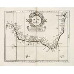
Provincia de Brasil cum Adiacentibvs Provinciis.
Detailed map of eastern and northern coastline of Brazil. North is to the right. Primarily coastal towns and islands are shown.Scarce map prepared by Hessel Gerritsz (158...
Place & Date: Leiden, Elzevier, 1625
Selling price: $750
Sold in 2013
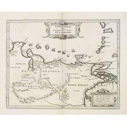
Venezuela, atque Occidentalis Pars Novæ Andalusiae.
Coastline of Venezuela with little interior development. Including Aruba, Bonaire, Curaçao, etc.Scarce map prepared by Hessel Gerritsz (1581-1632), former apprentice of ...
Place & Date: Leiden, Elzevier, 1625
Selling price: $300
Sold in 2013
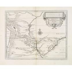
Ó Prov. De Rio De La Plata: cum adiacentibus Provinciis. quas vocant Tvcvman Et Sta. Cruz De La Sierra.
Detailed map of Rio de la Plata region of Brazil west to the Chilean coast and north to Peru. Decorative title and scale cartouche with face, fruit, and vines. In the cen...
Place & Date: Leiden, Elzevier, 1625
Selling price: $250
Sold in 2013
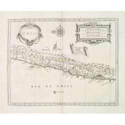
Chili.
Fine map showing mainly the coastline of Chile with large title, scale and key cartouche in the blank interior. North is to the left.. In the upper center of the map a la...
Place & Date: Leiden, Elzevier, 1625
Selling price: $255
Sold in 2013
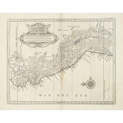
Peru.
Fine map showing mainly the coastline of Peru with large title and scale cartouche in the blank interior. North is to the left.. In the lower right of the map a large com...
Place & Date: Leiden, Elzevier, 1625
Selling price: $275
Sold in 2013