Browse Listings in Africa > Southern Africa > Madagascar & other Islands
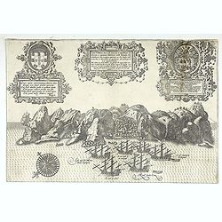
Insula D. Helenae sacra coeli dementia et aequabilitate . . .
From Linschoten, Itinerario. 3 Renaissance cartouches, 1 compass rose and many sailig ships. -
Place & Date: Amsterdam, 1589
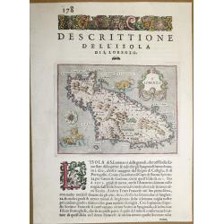
Dell ‘Isola Di San Lorenzo, Madagascar.
A beautiful map of Madagascar, from "L'Isole piu Famose del Mondo" - the most famous islands of the world by Thomas Porcacchi and engraved by Girolamo Porro. Th...
Place & Date: Padua, 1590
Selling price: $100
Sold in 2018
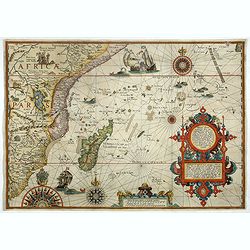
Delineatio orarum maritimarum, terræ vulgo indigetatæ terræ do Natal, item Sofalæ, Mozambicæ & Melindæ, insulæque Sancti Laurentii. . . / Affbeeldinghe der custen des landts genaempt terra do Natal, item van alle de custen...
A superbly decorative early chart engraved by Arnold van Langren showing the African coastline of the Indian Ocean from the Cape to Natal, Mozambique and Madagascar. Tool...
Place & Date: Amsterdam, 1598
Selling price: $4000
Sold in 2022
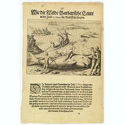
How the inhabitants catch whales off the east coast of Madagascar.
When the natives of Santa Marta, off the east coast of Madagascar see a whale, they row out in their little boats and throw out a rope with a large hook on the end. When ...
Place & Date: Frankfurt, 1598
Selling price: $85
Sold in 2022
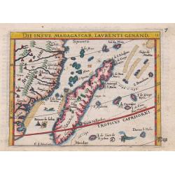
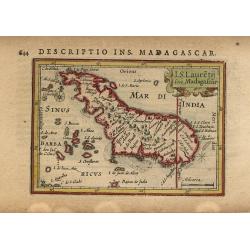
Die Insul Madagascar, Laurenti Genand.
An attractive miniature copper-engraved map of Madagascar from the German edition of Abraham Ortelius' Epitome, With German title at the top, a ship, two sea-monsters and...
Place & Date: Frankfurt, 1604
Selling price: $140
Sold in 2015
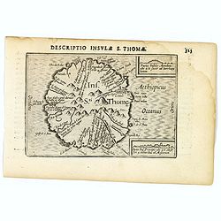
St. Thomas.
A lovely miniature map of the one time Portuguese island of St. Thomas, published by Petrus Bertius, in Amsterdam at the beginning of the seventeenth century. The island ...
Place & Date: Amsterdam, 1606
Selling price: $150
Sold in 2023
![I.S. Laurentij. [Madagasgar]](/uploads/cache/43290-250x250.jpg)
I.S. Laurentij. [Madagasgar]
A nice miniature map of the Indian Ocean island of Madagasgar, published by Petrus Bertius in Amsterdam early in the seventeenth century. North is orientated to the left....
Place & Date: Amsterdam, 1606
Selling price: $50
Sold in 2021
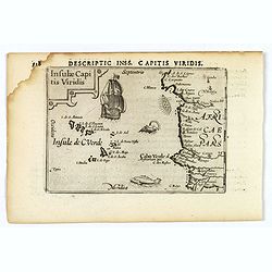
Insulae Capitis Viridis.
A nice early miniature map by Petrus Bertius of the Cape Verde islands in the Atlantic Ocean, off the coast of Africa. With a decorative, strap-work title cartouche, a g...
Place & Date: Amsterdam, 1606
Selling price: $60
Sold in 2021
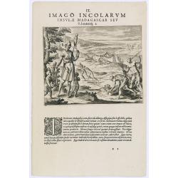
Imago Incolarum Insulae Madagascar Seu.
Showing locals of Madagascar. With a explanatory text in Latin, underneath, explaining "The country-folk of the island of Madagascar often carry about with them thre...
Place & Date: Frankfurt, 1609
Selling price: $60
Sold in 2017
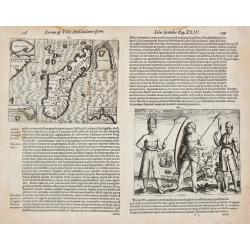
I.S. Laurentii. / Rex Ins. S. Maria Indigenarum I.S. Laurentii imagines.
Johan Isaac Pontanus. Rerum et Urbis Amstelodamensium historia, with descriptions of the voyages made by the Dutch to Novoya Zemlya and the first voyage of the Dutch to t...
Place & Date: Amsterdam, 1611
Selling price: $180
Sold
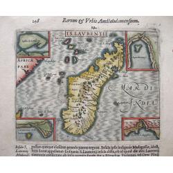
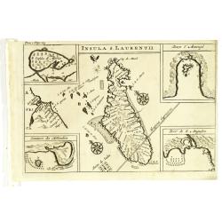
I.S. Laurentii. (Madagascar).
A highly detailed map of Madagascar with 4 insets with detail maps and a print on verso depicting the inhabitants of the island. Even though this map is much smaller than...
Place & Date: Amsterdam, 1611
Selling price: $90
Sold in 2014
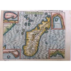
I.S. Laurentii. (Madagascar).
A highly attractive and detailed miniature map of Madagascar with 4 insets embodying details of the map. A detailed etching on verso depicting the inhabitants of the isla...
Place & Date: Amsterdam, 1614
Selling price: $120
Sold in 2021
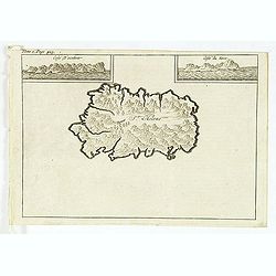
I.S. Lauretij sive Madagascar
Charming miniature map of Madagascar that the Portuguese named St. Laurence. North is oriented to the left and the Tropic of Capricorn cuts across the southern tip of the...
Place & Date: Amsterdam, 1616
Selling price: $80
Sold
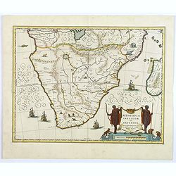
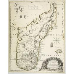
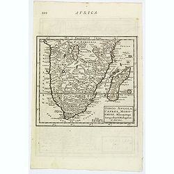
Aethopia Inferior vel Exterior.
A very attractive map of southern Africa depicting the area just prior to the settlement of the Cape Province by the Dutch. The area shown is from the Congo River basin a...
Place & Date: Amstrdam, ca 1640
Selling price: $180
Sold in 2019
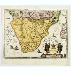
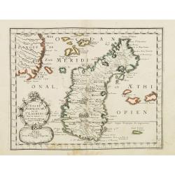
Aethopia Inferior vel Exterior Monomotapa.
A very attractive map of the African region south of the Congo, probably derived from Blaeu, and based on Portuguese exploration. The interior is filled with indigenous ...
Place & Date: Frankfurt ca 1650
Selling price: $110
Sold in 2018
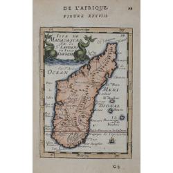
ISLE DE MADAGASCAR ou de St. LAURENS.
Very fine map of Madagascar, first published by Sanson in 1657. A detailed map of Madagascar and near islands.Sanson notes the source of his map as Livio Sanuto and other...
Place & Date: Paris 1657
Selling price: $95
Sold in 2019
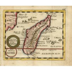
Carte de l'Isle Madagascar dite autrement Madecale et de S. Laurens et aujourd'hui l'Isle Dauphine avec les Coste de Cofala et du Mozambique en Afrique . . .
Uncommon map of the island Madagascar with the African coast countries Mozambique and Cofala. Numerous place names, soundings and sand banks are shown round the island an...
Place & Date: Paris, 1666
Selling price: $375
Sold in 2013
Isle D'Auphine, communement Nommée pae les Europeens Madagascar. . .
Fine map of Madagascar, also showing the Comoros Islands in the North West and the Reunion Island in the South East.With decorative title cartouche representing some nati...
Place & Date: Paris, 1667
Selling price: $1500
Sold in 2013
Isle de Madagascar. . .
Map of Madagascar prepared by N.Sanson and published by Pierre Mariette.Published in an early edition of the small Sanson atlas L'Europe Dediée a Monseigneur . . . Le Te...
Place & Date: Paris, P. Mariette, 1667
Selling price: $170
Sold in 2008
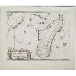
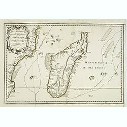
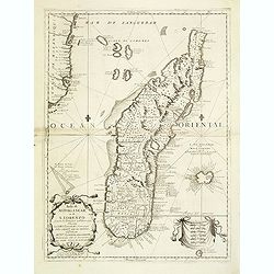
Insula S. Laurentii, vulgo Madagascar.
Map of the island of Madagascar and coastline of Mozambique. Title and impressum in a nice cartouche with figures and animals at bottom left. Shows also the islands arou...
Place & Date: Amsterdam, 1667
Selling price: $160
Sold in 2022
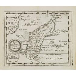
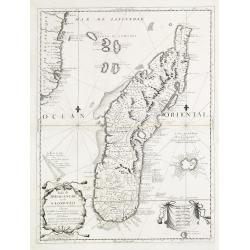
Isle de Madagascar dite de St.Laurens et aujourd'hui Isle Dauphine.
Uncommon miniature map of Madagascar from Pierre Duval's La Geographie Universeille dated 1676. Following his Cartes de geographie in 1657, Pierre Duval published this sm...
Place & Date: Paris, 1676
Selling price: $75
Sold in 2008
Insula Madagascar dicta St. Laurens.
Handsome miniature map of Madagascar and surrounding islands.Pierre Duval was Nicolas Sanson's nephew and pupil. He published a wide range of atlases and individual maps ...
Place & Date: Nuremberg, 1679
Selling price: $135
Sold
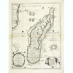
Insula S.Laurentii vulgo Madagascar.
Showing in great detail the island of Madagascar. In upper left hand corner part of Mozambique.
Place & Date: Amsterdam, 1680
Selling price: $230
Sold
Isle de Madagascar dite de St Laurens ou L'isle Daufine.
Copper engraved map shows the Island of Madagascar. from Mallet's "Description de l'Univers" 1st edition. Blank verso.
Place & Date: Paris 1683
Selling price: $60
Sold in 2014
Isola di Madagascar o di S. Lorenzo Scoperta dà Portoghesi nell anno 1506..
Decorative and highly detailed map of Madagascar, including 2 decorative cartouches and other embellishments.The remarkable Vincenzo Coronelli (1650-1718), was a Francisc...
Place & Date: Venice 1690
Selling price: $450
Sold
Isola di Madagascar o di S. Lorenzo Scoperta dà Portoghesi nell anno 1506. . .
A beautiful and flamboyantly engraved large-scale map of Madagascar, Bourbon and part of the coast of Mozambique. On verso a smaller map Madagascar (170x123mm) The map is...
Place & Date: Venice, ca. 1696
Selling price: $480
Sold
Isola di Madagascar, o di S. Lorenzo . . .
A beautiful and flamboyantly engraved large-scale map of Madagascar, formerly named San Lorenzo by the discoverers, the Portuguese. Shows also in detail the Comorra Islan...
Place & Date: Venice, 1698
Selling price: $800
Sold in 2013
Isola di Madagascar, ò di S. Lorenzo scoperta dà Portoghesi nell'Anno 1506. . .
A striking, early map of the island of Madagascar, also showing part of the Mozambique coastline, the Comoros Islands and Reunion. The remarkable Vincenzo Coronelli (1650...
Place & Date: Venice, 1698
Selling price: $550
Sold in 2021
![[Lot of 9 maps / prints of SOUTH AFRICA] Carte du Congo et du Pays des Cafres.](/uploads/cache/19581-(1)-250x250.jpg)
[Lot of 9 maps / prints of SOUTH AFRICA] Carte du Congo et du Pays des Cafres.
Guillaume de l 'Isle's influential map of South Africa. Guillaume de l' Isle (1675-1724), Royal Geographer, was the most influential cartographer of the first quarter of ...
Place & Date: Paris, c. 1700
Selling price: $230
Sold in 2022
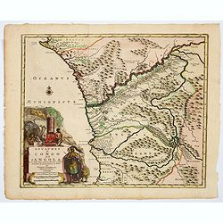
Congo, Angola, Cafres, Monoemugi, Monomotapa, Zanguebar & Madagascar.
The nice map that extends from Central Africa - Congo to Mombasa to the Cape of Good Hope. Herman Moll (fl.1678-1732). was a bookseller, geographer and engraver. A native...
Place & Date: London, ca 1701
Selling price: $95
Sold in 2019
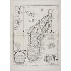
Insula S. Laurentii.
Map of Madagascar, with four inset maps. From the French reissue of the account of early Dutch voyages first published in 1608 by Commelin. The French translation was car...
Place & Date: Amsterdam, E. Roger, 1702
Selling price: $120
Sold in 2012
St Helene.
Uncommon small map of St. Helena, with two coastal profile inset maps.From the French reissue of the account of early Dutch voyages first published in 1608 by Commelin. T...
Place & Date: Amsterdam, E. Roger, 1702
Selling price: $80
Sold in 2012
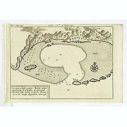
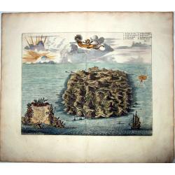
Isle St. Maurice. Ins. cygnae a Lusit, a nostris Maurity nomine indigitata, sita ad 21um gradum ab Equinoctiali Meridiem versus inventa et detecta Decima-jctava die mensis septembris anno 1598.
A bay at ST. Mauritius, a small island located in the South-West Indian Ocean, off the east coast of Madagascar. Mauritius is well known for the Dodo, the extinct bird. T...
Place & Date: Amsterdam, E. Roger, 1702
Selling price: $80
Sold in 2021
Carte particuliere de L´Isle Dauphine ou Madagascar et St Laurens.
A big, beautiful, brightly colored map of Madagascar, Comoros, I. De Bourbon, Santa Apolonia, I. Ioan de Lisboa and other islands. With an inset map of Baye St. Augustin....
Place & Date: Amsterdam, ca. 1710
Selling price: $300
Sold in 2017
SAINT HELENA.
This fine hand colored original copper-plate engraved antique map of the Island of St Helena in the southern Atlantic, was published by Pieter Van der Aa. With cherubs, s...
Place & Date: Amsterdam, ca 1710
Selling price: $150
Sold in 2021
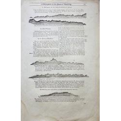
A Description of the Island of Mauritius - Don Mascarenhas Island.
No’s 23 – 24 A woodblock chart on a double sided sheet by Samuel Thornton showing the approaching coast line of Mauritius 23’ on the verso 24’ shows Don Mascarenh...
Place & Date: London 1711
Selling price: $80
Sold in 2015
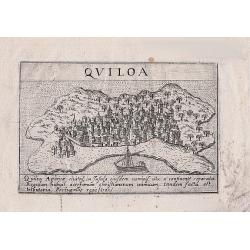
Quiloa (Kilwa - Tanzania)
A woodcut print of Quiloa (Kilwa) off the coast of Tanzania. An scarce small map of the island.
Place & Date: Padua, 1713
Selling price: $45
Sold in 2018
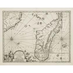
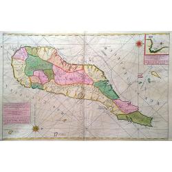
Carte particuliere de L'Isle Dauphine ou Madagascar..
An impressive large sheet of the island of Madagascar. Numerous place names, soundings and sand banks are shown round the island and the regions are defined in original ...
Place & Date: Amsterdam 1720
Selling price: $2200
Sold in 2012
Royaumes de Congo et d'Angola. . .
A delightful and decorative map of the African regions of Congo and Angola. The map shows from Capo de Lopo Gonsalves in the north, through Loango, southwards to the Baya...
Place & Date: Leiden, ca 1720
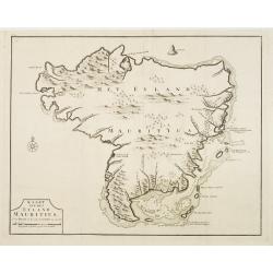
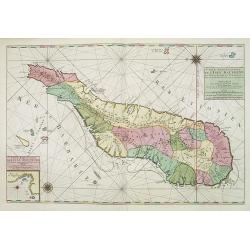
Kaart van het eyland Mauritius.
Fine map depicting the island of Mauritius. Little interior detail is given but the coastlines, settlements and principal coastal features are identified. An attractive e...
Place & Date: Amsterdam 1724
Selling price: $600
Sold