Browse Listings
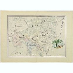
Asie.
Manuscript map made by miss Marie Demeule, dated Elbeuf 1879. Elbeuf is a town within the Upper Normandy region in France.In the 19th century many students, and quite oft...
Place & Date: France, Elbeuf, 1879

(The City And Harbour Of Sydney From Near Vaucluse.)
One of the most sought after views of the city and harbour of Sydney seen from Near Vaucluse, 1852. Magnificent hand-colored tinted lithograph and finished by gum-Arabic....
Place & Date: London, J. Hogarth, 1852

Imperium Russicum, cum regionibus adiacentibus duabus Tabulis ex optima quae A. 1784 tribus foliis comparavit Mappa geographica, aliisque subsidiis delineatum a C. Mannert, Tabula Ima. . .
A detailed map of the European part of the Russian Empire. Scarce map. Copper etching by C. Mannert and edited by Adam Gottlieb Schneider and Johann Christoph Weigel. Man...
Place & Date: Nuremberg, 1794
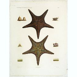
Astéries.
Decorative engraving of star fishes, by Macret and Leleu. Marie Jules César Lelorgne de Savigny (April 5, 1777 - October 5, 1851) was a French zoologist. In 1798 he trav...
Place & Date: Paris, 1822
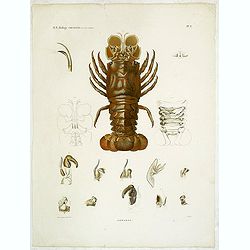
Hommards.
Decorative engraving of a lobster, by Tresca. Marie Jules César Lelorgne de Savigny (April 5, 1777 - October 5, 1851) was a French zoologist. In 1798 he traveled to Egyp...
Place & Date: Paris, 1822
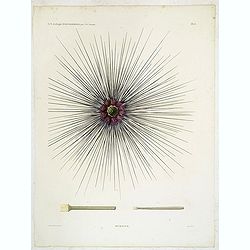
Oursins.
Decorative plate of a sea urchin, engraved by Boquet. Marie Jules César Lelorgne de Savigny (April 5, 1777 - October 5, 1851) was a French zoologist. In 1798 he traveled...
Place & Date: Paris, 1822

Military map of the countries between Odessa & Perekop with the stations of the Russian forces.
Rare colored linen-backed map showing Russian troop positions and Odessa Batteries. On the inside of the cover a list of "Wyld's list of recent publications : seat o...
Place & Date: London, ca. 1855

The town & harbour of Sevastopol with the batteries & approaches. . .
Rare colored linen backed map showing the harbour and town of Sevastopol, with soundings. In upper left corner a inset map (65x150mm) of the Black Sea. In bottom part a l...
Place & Date: London, March 27th, 1854

20 small lithographed views of Washington DC and Georgetown.
20 small lithographed town-views of Washington DC and Georgetown, cut out from a larger sheet. Showing the East Front of the Capitol, Treasury, Smithsonian Institute, Pre...
Place & Date: Casimir Bohn, Washington, D.C.: 1849

Parte orientale della China.. / Parte occidentale della China. (2 sheets)
The map depicts the eastern part of China with Korea -correctly- as a peninsula. Formosa is included as well. Japan is partly visible i.e. the area of Yamaguchi, strait K...
Place & Date: Venice, 1695

Carte générale de L'Empire Ottoman en Europe et en Asie dressée par Henri Kiepert . . .
Large School wall map of Turkish Empire printed in chromo-lithography. Published by Dieter Reimer and printed by Ferdind Barth in Berlin. This rare map has two insets in ...
Place & Date: Berlin, Verlag von Dietrich Reimer, 1867

Carta terza Generale del' Asia.
Rare first state of this important chart showing part of the north coast of New Guinea and islands of the Pacific Ocean. To the north of Japan the landmass of Isola di Ie...
Place & Date: Florence, 1646

Vaisseau du premier rang portant pavillon d'amiral.
Fine double-page engraved plate of a naval vessel, with the various parts of the ship numbered and identified. From Mortier's "Neptune François". From Mortier'...
Place & Date: Amsterdam, 1695

Marcomania hoggidi Merchesato de Moravia. . .
Although Komensky's map of Moravia was already known in his time, Coronelli used the obsolete map by Fabricius, with a lot of locations added by the publisher's unchained...
Place & Date: Venice, 1696

La Pologne Dressée sur ce qu'en ot donné Starovolsk, Beauplan, Hartnoch. . .
Large map of Poland, Lithuania, Belarus and part of Ukraine. The map is filled with detail and decorated with a title cartouche flanked by mythological figures.According ...
Place & Date: Paris, 1773 - 1780

Venise. 1700
Extremely rare panoramic broad sheet panoramic town-view of Venice with underneath in letter press a description of the town's history. The view measures more than 1 mete...
Place & Date: Paris, 1699

Constantinopolitanae urbis effigies ad vivum expressa, quam Turcae Stampoldam vocant. A° MDCXXXV.
Large, decorative view of the city of Constantinople, with legend across the bottom. It is beautifully engraved with quaint scenes of everyday life, including hunters wit...
Place & Date: Frankfurt, 1635

Tractus Danubii, Fluminis in Europa Maximi, A Fontibus, Per Germaniam. . .
This is Blaeu’s first map of the Danube and surrounding regions. The Danube River runs through the map from the top left with its headwaters in the German Black Forest ...
Place & Date: Amsterdam, 1634

Carte des Possessions Françoises et Angloises dans le Canada et partie de la Lousiane. . .
Proof state. Here without the decorations around the title cartouche in the what is called in the reference books the first state the cartouche in upper left . No double ...
Place & Date: Paris, 1756

Parte settentrionale dell' Irlanda / Irlanda parte meridionale . . .
A beautiful and flamboyantly engraved grand two-sheet map of Ireland. Embellished with two cartouches, a vessel under sail and a sea monster.The map is the product of the...
Place & Date: Venice, 1696

Nouvelle et exacte description du globe terrestre reveue corrigée et augmente´e suivant les derniéres relations des Anglais et Hollandois. Par Guillaume Blaeu 1645.
Extremely rare and decorative "carte a figures" world map published by Anthoine de Fer. The double hemisphere world map is surrounded by constellations of the A...
Place & Date: Paris, 1645
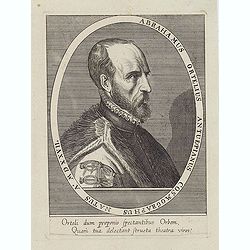
Abrahamus Ortelius Antuerpianus cosmographus natus a. MDXXVII
Portrait of Abraham Ortelius (Abraham Ortel), famous cartographer born in Antwerp and after studying Greek, Latin and mathematics set up a business there with his sister,...
Place & Date: Antwerp, c.1650
Selling price: $225
Sold in 2023

Map of the Great Salt Lake And Adjacent Country in the Territory Of Utah. Surveyed in 1849 and 1850, under the orders of Col. J.J. Abert ...
Map of the Great Salt Lake And Adjacent Country in the Territory Of Utah. Surveyed in 1849 and 1850, under the orders of Col. J.J. Abert .. by Capt. Howard Stansbury .. a...
Place & Date: Ackerman, New York, 1852

Le comte de Namur et partie des Duchez de Brabant. . .
Decorative map centered on Namen and including the towns of Liege, Leuven, Charleroi, Dinant, Luxemburg, etc. by François Jollain (ca. 1641 – 18 April 1704).Rare "...
Place & Date: Paris, c. 1692

Carte du Palatinat du Rhin.
Decorative "carte à figures"- map centered on Koblenz, Metz, Strasburg, Manheim and Heidelberg, with the river Rhine by François Jollain (ca. 1641 – 18 Apri...
Place & Date: Paris, ca. 1688

Les vallées du Piemont. Habitees par les Vaudois ou Berbets. . .
Detailed map of Piedmont region covering French and Italian territories. Surrounded by a French text description "Description des vallées du Piemont qu'habitent par...
Place & Date: Paris, 1690

Il Cuscho citta principale della provincia del Peru.
A very desirable and scarce item of this decorative and early bid's-eye town-plan of the Inca city of Cuzco. Several figures shown inside the city walls and on the hillsi...
Place & Date: Lyons, 1564
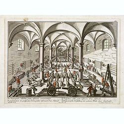
Per telecopium exhibitio partis inferioris armamentarii. / Representation en perspective de la partie inferieure d'un arsenal. . .
RARE. Engraved optical print by Georg Balthasar Probst of a arsenal.
Place & Date: Augsburg, 1750

Peregrinations divi Pauli Tyrus Corographicus. . .
A beautifully executed and very rare map showing the peregrinations of St. Paul in the Eastern Mediterranean. The Mediterranean is ornated with two ships and two sea mons...
Place & Date: Paris, ca. 1640

Tableau des guerres de Frédéric le Grand: ou plans figurés de vingt-six batailles rangées, ou combats essentiels donnés dans les trois guerres de Silésie. . .
The book includes a large folded map "Tableaux des Guerres de Frédéric le Grand", showing a map of Prussia, with present-day Poland and Eastern Germany surrou...
Place & Date: Potzdam, Strasbourg, Paris, 1788
![Carte de la coste orientale de la Chine depuis Amoy, jusqu'à Chusan avec une partie de l'Isle Formose [with] Plan du port d'Amoy ou Emouy.](/uploads/cache/33583-250x250.jpg)
Carte de la coste orientale de la Chine depuis Amoy, jusqu'à Chusan avec une partie de l'Isle Formose [with] Plan du port d'Amoy ou Emouy.
Important French chart of the China Sea with the coast of Northern China, including a large depiction of Formosa.Latitude and longitude scales, compass rose and system of...
Place & Date: Paris, Jean-François Robustel, 1745

Histoire de la Guerre Civile en Amerique par M. Le Comte de Paris, Ancien Aide de Camp du General Mac Clellan (McClellan). ...
These 30 maps were made by Vorzet to accompany Louis Phillipe d'Orleans' (Comte de Paris) multi volume "Histoire de la Guerre Civile en Amérique". The set incl...
Place & Date: Paris. Michel Levy Freres, 1875
![[Manuscript chart on vellum of the Java Sea]](/uploads/cache/33613-250x250.jpg)
[Manuscript chart on vellum of the Java Sea]
One of the few manuscript charts on vellum in private hands, signed by Isaac de Graaf. ORIGINAL MANUSCRIPT MAP IN RED, GREEN AND BLACK INK showing the Java Sea centered o...
Place & Date: Amsterdam, 1743
![CH'ONHA CHIDO [Atlas of all under Heaven]](/uploads/cache/33625-250x250.jpg)
CH'ONHA CHIDO [Atlas of all under Heaven]
The Ch’onha chido [Atlas of all under Heaven] is a late 18th century copy of the traditional Korean atlas produced in the early Choson dynasty (1392-1910). One of the m...
Place & Date: Korea, ca. 1790

Karte von Europa im Jahre 1870 nach einem französischen Holzschnitte.
Satirical illustration by Paul Hadol showing disposition of power in Europe at the beginning of 1870. Satirical print depicting a map of Europe in which the countries are...
Place & Date: Hamburg, Fuchs, 1914

Potentissimo Borussorum Regi Friderico Wilhelmo Maiestate, Fortitudine Clementia Augustissimo Hancce Lithuaniam Borussicam : in qua luca coloniis Salisburg., ad incolendum Regio nutu...
Potentissimo Borussorum Regi Friderico Wilhelmo Maiestate, Fortitudine Clementia Augustissimo Hancce Lithuaniam Borussicam : in qua luca coloniis Salisburg., ad incolendu...
Place & Date: Nuremberg, 1735

Carte von West=Gallizien welche auf allerhöchsten Befehl Seiner Kaiserlich oesterreichischen und Königlich apostolischen Majestät in den Jahren 1801 bis 1804. . .
Important early map of Western Galicia, as given to Austria by the third Partition of Poland (1795). Due to its long development period, a rare map rich in detail shows t...
Place & Date: Vienna, (1808) after 1811

Maris Pacifici.
From the rare Dutch text edition of the Theatrum of which according to van den Broecke only 100 copies are printed.This was the first printed map to be devoted solely to ...
Place & Date: Antwerp, 1598

Het gezandtschap der Neerlandtsche Oost-Indische Compagnie, aan den grooten Tartarischen Cham, Den tegenwoordigen Keizer van China. . .
Third edition of this beautifully illustrated work on China. The first edition was published in 1665.Jan Nieuhof was a "Dutch traveler and adventurer" (1618-72)...
Place & Date: Amsterdam, W. Waasberge, 1693

Carta geographica generalatus carlostatuensiscum adgacentibus confinis turcicis et venetis...
Fine and rare manuscript map of Croatia and the Dalmatian coast from the early eighteenth century. Oriented to the south the map details the Venetian, Austrian and Turkis...
Place & Date: Venice , c. 1700