Search Listings matching "figured-border" in Map Types
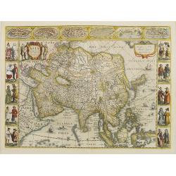
Asia recens summa cura delineata.
This is the rare early issue with decorative paneled borders. In upper border views and plans of Famagusta, Rhodos, Damascus, Jerusalem, Aden and Ormus. Originally engrav...
Place & Date: Amsterdam, 1632
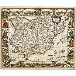
Nova et accurata Tabula Hispaniae. . .
Second state. This "carte à figures"- map of Spain and Portugal shows the geographical image introduced by Hessel Gerritsz's 1612 wall map of Spain. The map is...
Place & Date: Amsterdam, 1633

A new mape of Ye XVII Provinces of Low Germanie.
Showing all 17 Provinces of the Netherlands before the split between Spain and the Protestant Provinces under the House of Orange.The map was first published. At the same...
Place & Date: London, 1676
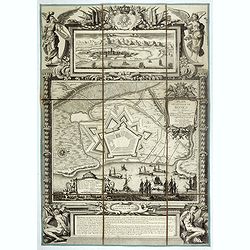
Plan de la ville de Roses avec les attaques.
Very rare and beautiful plan engraved by Pierre Lepautre, of the city of Roses in Catalonia, and celebrating the victory and capture of the city by Louis XIV in June 1693...
- $1500 / ≈ €1404
Place & Date: Paris, 1700