Search Listings matching "ukraine"
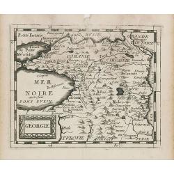
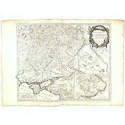
Géorgie.
Uncommon miniature map of Ukraine, from Pierre Duval's La Geographie Universeille dated 1676. Following his Cartes de geographie in 1657, Pierre Duval published this smal...
Place & Date: Paris, 1676
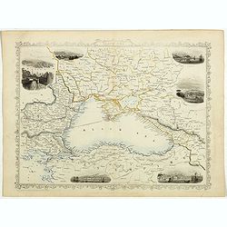
Black Sea.
Decorative steel engraved map of the Black Sea with inset views of Sebastopol and Odessa. There are also vignettes of Constantinople, Sinope and Varna. Taken from "T...
Place & Date: London, London Printing and publishing Company of London, ca. 1851
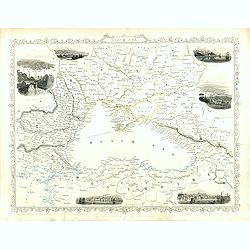
Black Sea.
Decorative steel engraved map of the Black Sea with inset views of Sebastopol and Odessa. There are also vignettes of Constantinople, Sinope and Varna. Taken from "T...
Place & Date: London, London Printing and publishing Company of London, ca. 1851

Karte der Ukraina.
A large political, economical and transportation map of Ukraine, printed three months after the beginning of the WW II in Ukraine. Shows the newest borders, streets and r...
Place & Date: Vienna: Freytag u. Bernd u. Artaria August 1941

French composite atlas made up of rare maps published by Parisian editors from the 17th century , mainly by G. Jollain including scarce maps of America.
A rare French composite atlas including 90 maps, published by Parisian publishers from the 17th century, mainly by Gérard I Jollain, or by maps bought from Dutch publish...
Place & Date: Paris, ca. 1675
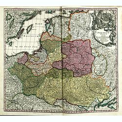
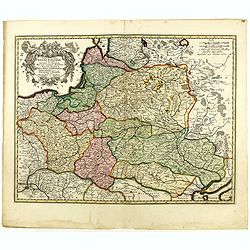
Poloniae Regnum ut et Magni Ducatus Lithuaniae . . .
Detailed map of Poland and the Baltic regions, extending in the south to Ukraine and northern Hungary.Here in its second state, now with added letters to the border scale...
- $750 / ≈ €702
Place & Date: Augsburg, 1735
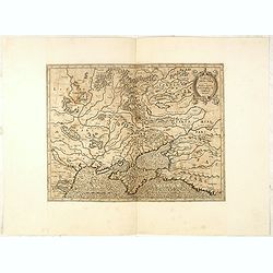
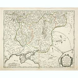
Partie Méridionale de la Russie Europeenne ou sont distinguees exactement toutes les Provinces, d'après le detail de l'Atlas Russien.
Detailed map of southern European Russia, including Yugoslavia. The map was first published by the Venetian cartographer and publisher François (Père) Santini and first...
- $400 / ≈ €374
Place & Date: Venice, 1784
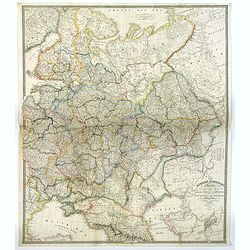
The Russian Dominions in Europe ... with the Post Roads & New Governments from the Russian Atlas of 1806 by Jasper Nantiat.
A two-sheet wall map of Russia covering from the Artic Sea to the Black and Caspian Seas and from East Prussia and Moldova to the Aral Sea and Tobolsk. Modern day nations...
- $500 / ≈ €468
Place & Date: London, ca. 1843
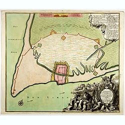
Ichnographia munitissimae Arcis Otzakoff quae Ao. 1737, die 3 Iulÿ auspicÿs Supremi Campi Mareschalli Comitis de Münnich ab exercitu Russorum vi occupata . . .
A striking image of this fortified Russian outpost on the Black Sea at Otzakoff, northeast of Odessa.
- $1250 / ≈ €1170
Place & Date: Augsburg, 1737

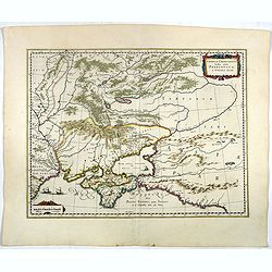
Carte de la Petite Tartarie Dresee par ordre de l'Imperatries de toutes las Russies.
The very rare first edition of De Leth's map of the southern part of Ukraine, with detailed annotations regarding the Cossacks and an explanatory key. Based on a Russian ...
- $1750 / ≈ €1638
Place & Date: Amsterdam, ca. 1785
Carte de l'empire des Russies en Europe partie meridionale
Uncommon and detailed map of Ukraine.Published by Pierre Bourgoin in 1784 in his uncommon "Atlas Élémentaire de la Géographie", published at rue de la Harpe ...
- $350 / ≈ €328
Place & Date: Paris, 1784
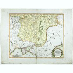
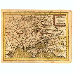
Taurica Chersonesus, Nostra aetate Przecopsca, et Gazara dicitur.
Part of Russia with in the north Smolensk and Moscow and in the south the Black Sea. More about Willem Blaeu. [+]
- $300 / ≈ €281
Place & Date: Amsterdam, 1644
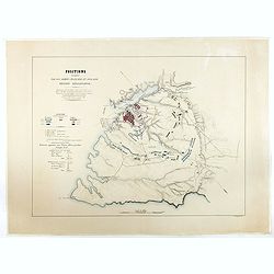
Positions occupées par les armées françaises et anglaises devant Sevastopol.
Map of the French and English armies positions in Sebastopol.Read more about The Crimean War - The Siege of Sevastopol. [+]
- $350 / ≈ €328
Place & Date: Paris, 1854
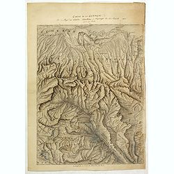
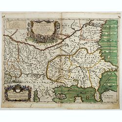
Carte de la Georgie et du Pays des Ossetes, Tcherkesses et Mitzdcheghi, Par Jules Klaproth (1823).
Detailed manuscript map of Georgia, based upon an 1823 map by Jules Klaproth. The map depicts the rugged terrain of Georgia and southern Russia in impressive detail from ...
- $4000 / ≈ €3743
Place & Date: Paris, ca. 1823
![Tabula III Asiae. [Caucass and Armenia.]](/uploads/cache/47571-250x250.jpg)
Tabula III Asiae. [Caucass and Armenia.]
Ptolemaic map of the region south of the Caucasus Mountains and between the Caspian Sea as far south as the headwaters of the Tigris River in the south and the Black Sea,...
- $750 / ≈ €702
Place & Date: Lyons, M. Servetus, 1525
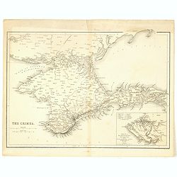
The Crimea.
Map of Crimea and the Sea of Azov. In lower right corner inset map showing Sebastopol region.
- $50 / ≈ €47
Place & Date: London, 1854
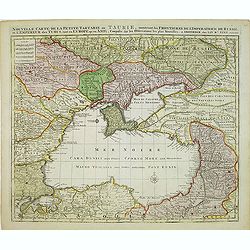
Nouvelle Carte de la Petite Tartarie et la Mer Noire, montrant les Frontieres de l'Impératrice de Russie et de l'Empereur des Turcs, tant en Europe qu'en Asie, Dessigné selon la proposition de G. De L'Isle et d'autres Auteurs.
Shows Ukraine and the Black Sea in a fine impression with original 18th-c. hand-coloring. Elwe published an atlas in 1792, mainly using the copperplates of Joachim Ottens...
- $500 / ≈ €468
Place & Date: Amsterdam, 1792
Sarmatia utraque europaea et asiatica. . .
Ancient map of the European part of Russia with the Ukraine. Dated 1654.Nicolas Sanson was to bring about the rise of French cartography, although the fierce competition ...
- $200 / ≈ €187
Place & Date: Paris, 1654
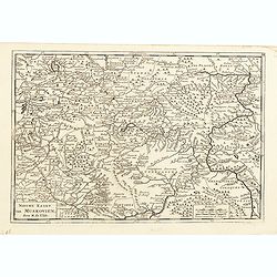
Nieuwe kaart van Muskovien door M. de l'Isle.
This lovely little map of the area surrounding Moscow is based on Delisle's map of the region. The map is bounded by Lake Ilmen in the north, the Volga River to the east,...
- $100 / ≈ €94
Place & Date: Amsterdam, 1735
Partie Méridionale de la Russie Europeenne ou sont distinguees exactement toutes les Provinces, d'après le detail de l'Atlas Russien.
Detailed map of southern European Russia, including Yugoslavia. The map was first published by the Venetian cartographer and publisher François (Père) Santini and first...
- $600 / ≈ €561
Place & Date: Venice, 1784
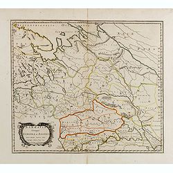
Carte du Gouvernement de Tauride, comprenant la Krimée et les pays voisins: dressée principalement d'après la carte faite sur les lieux pour le voyage de S.M. l'impératrice de Russie. . .
Rare map of southern Ukraine and the Crimea during the Second Russo-Turkish War (1787-92). Antique map of the Crimea during the Second Russo-Turkish War (1787-92), fought...
- $2500 / ≈ €2339
Place & Date: Paris, 1788
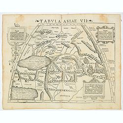
Tabula Asiae VII (Central Asia and Russia)
The first edition of Munster's map of the region north and east of the Black Sea and Caspian Sea, extending to the Imaus Mountains, based upon Claudius Ptolemy which appe...
- $400 / ≈ €374
Place & Date: Basel, Heinrich Petri, 1545
La Pologne Dressée sur ce qu'en ont donné Starovolsk, Beauplan, Hartnoch. . .
This is a late edition of the De L'Isle copper plate with a date of 1806. The copper plate was used many times and has several erased addresses. This one with address &qu...
- $750 / ≈ €702
Place & Date: Paris, 1806
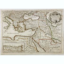
L'Empire des Turcs en Europe, en Asie et en Afrique.
A nice map showing the Turkish Empire, including an inset map of kingdom of Alger. Extending from Italy and the Eastern Mediterranean in the west to the Caspian Sea and P...
- $550 / ≈ €515
Place & Date: Paris, 1686
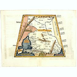
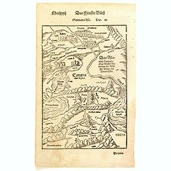
Tabula II Asiae.
A striking example of this wood-cut map depicts north of the Black Sea and west of the Caspian Sea (Ukraine, Russia, Georgia and Armenia). Ptolemy collected his data arou...
- $550 / ≈ €515
Place & Date: Lyons, 1535
Taurica Chersonesus, Nostra aetate Prezecopsca, et Gazara dicitur.
Early and detailed map of the Ukraine, Russia with in the north Smolensk and Moscow and in the south the Black Sea. Shows ports, fortified cities and the mouths of the Da...
- $300 / ≈ €281
Place & Date: Amsterdam, ca. 1625
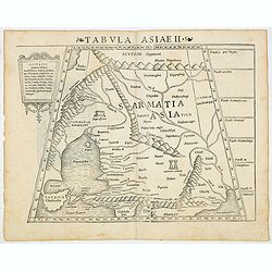
Tabula Asiae II (Black Sea and Caspian Sea)
The first edition of Munster's map of Ukraine and the region north of the Black Sea, based upon Claudius Ptolemy which appeared in his "Geographia Universalis",...
- $500 / ≈ €468
Place & Date: Basel, Heinrich Petri, 1545
![[Untitled map of Black Sea].](/uploads/cache/37349-250x250.jpg)
[Untitled map of Black Sea].
Very detailed and rare map of Black Sea region. The map has elaborate floral borders. Prepared by Joseph Scheda in Vienna.
- $200 / ≈ €187
Place & Date: Vienna, 1845-1847
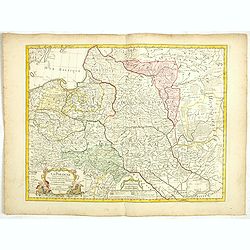
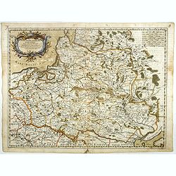
Tabula nova totius regni Poloniae. . .
Map of Poland, Lithuania, Latvia, Belarus and Ukraine with decorative cartouche in the upper left corner.Published by Nicolaas Visscher after N. Sanson.
- $900 / ≈ €842
Place & Date: Amsterdam, 1690
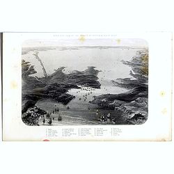
Birds-eye view of the Straits of Kertch & Sea of Azoff.
Steel engraving of the harbour at Sebastopol and the Straits of Kertch and Sea of Azoff in the Ukraine published by James Virtue around 1860.Title in upper margin. With a...
- $75 / ≈ €70
Place & Date: London, 1870
La Bulgaria ela Romania con Parte di Marcedonia. . .
Scarce map of the region along the Danube River and to the south. Extends to include part of the Sea of Azov and the northern extreme of the Aegean Sea. Elaborate militar...
- $600 / ≈ €561
Place & Date: Rome, 1689
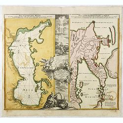
Das Caspische Meer / Das Land Kamtzadalie ...
Two maps on one sheet with the Caspian Sea on one side and northeastern Russia and Kamchatka on the other. The map of the Caspian Sea reflects the survey work of Russia�...
- $450 / ≈ €421
Place & Date: Nuremberg, 1720
Carte de l'empire des Russies en Europe partie meridionale
Uncommon and detailed map of Ukraine.Published by Pierre Bourgoin in 1784 in his uncommon "Atlas Élémentaire de la Géographie", published at rue de la Harpe ...
- $300 / ≈ €281
Place & Date: Paris, 1784
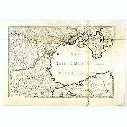
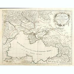
(Mer Noire ou Maieure, Pont Euxin.)
Very rare and detailed map of the Black Sea area prepared by Placide de Sainte-Hélène (1648-1734). and engraved by Claude-Auguste Berey (1651-1732).The map is of partic...
- $350 / ≈ €328
Place & Date: Paris, 1703
Stati della Corona di Polonia Divisa nella sue Principali Provincie e Palatinati da Guglielmo Sansone. . .
Rare map of Poland, Lithuania and the Ukraine. Copies of his first edition of 'Mercurio Geografico', published in 1674, do not contain a map of Poland. Only added in late...
- $1250 / ≈ €1170
Place & Date: Rome, 1678
(Untitled map of western shores of the Black Sea, with Bulgaria, Roumenia.)
Untitled map of western shores of the Black Sea, with Bulgaria, Roumenia. The map has elaborate floral borders. Prepared by Josef Schlacher in Vienna and published by K.K...
- $150 / ≈ €140
Place & Date: Vienna, K.K. Militär Geografisches Institut, 1875
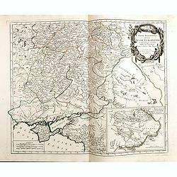
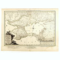
Taurica Chersonesus . . .
An attractive, detailed and early map of the Ukraine, Russia and surrounding regions between the northern coast of the Black Sea and Moscow.Shows ports, fortified cities ...
- $300 / ≈ €281
Place & Date: Amsterdam, 1630
Sarmatia Asie.
The map is showing the area of Armenia and Kazakhstan. From his Cosmographia, that great compendium of Renaissance knowledge. Sebastian Münster was born in Nierder-Ingel...
- $90 / ≈ €84
Place & Date: Basle, 1550-1580
Carte des environs de la Mer Noire. . .
Finely and crisply engraved map centered on Crimea, showing the Black Sea and its hinterland.Noteworthy topographical detail is shown. Decorative title cartouche in the u...
- $500 / ≈ €468
Place & Date: Venice, 1776 - 1784
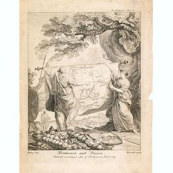
Britannia And Persia.
A finely engraved and unusual depiction of Britannia and Persia, two women with spears and shields holding a map between them. This map depicts a route through the Baltic...
- $800 / ≈ €749
Place & Date: London, 1753