Browse Listings

(Island of Pearls) Perlarum insula ob unionum copiam sic dicta.
A depiction of Cubagua as the Perlarum Insula (Island of Pearls), with in the foreground, two large ships send dinghies toward busy Native Americans collecting pearl oyst...
Date: Frankfurt, 1594
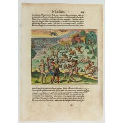
Cacodemon attacking the savages.
Cacodemon ("evil spirit") attacking the savages. Read more about "Les Grand Voyages" by Theodore De Bry [+]
Date: Frankfurt, 1594
![Arcis Carolinae delineatio [Jacksonville]](/uploads/cache/48530-250x250.jpg)
Arcis Carolinae delineatio [Jacksonville]
Depicting Fort Caroline in Jacksonville, Florida. A French expedition, organized by Protestant leader Admiral Gaspard de Coligny and led by the French Explorer Jean Ribau...
Date: Frankfurt, 1594
![[The French left in Fort Charles suffer the scarcity of provisions. (Virginia]](/uploads/cache/48529-250x250.jpg)
[The French left in Fort Charles suffer the scarcity of provisions. (Virginia]
An Indian town visited by the French of Charlesfort in search for food. After a drawing by LeMoyne. Charlesfort-Santa Elena is on what is now Parris Island, South Carolin...
Date: Frankfurt, 1594
![Pisces in mari alati [flying fish attack]](/uploads/cache/48527-250x250.jpg)
Pisces in mari alati [flying fish attack]
Flying fish attacking a Portuguese ship in the West Indian Waters.Read more about "Les Grand Voyages" by Theodore De Bry [+]
Date: Frankfurt, 1594
![[Navel battle between Portuguese and French Battle off Buttugar (Brazil).]](/uploads/cache/48526-250x250.jpg)
[Navel battle between Portuguese and French Battle off Buttugar (Brazil).]
Navel battle between Portuguese and French in the seas off the Poti guaran Territories in Brazil.Read more about "Les Grand Voyages" by Theodore De Bry [+]
Date: Frankfurt, 1594
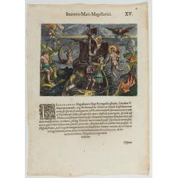
Inventio Maris Magallanici.
Allegorical scene allegorical image celebrating the circumnavigation of the earth by Ferdinand Magellan. The image shows Magellan on board of his ship, surrounded by myth...
Date: Frankfurt, 1594
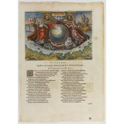
Americae Retectio (Allegory of the Discovery of America)
Allegorical scene commemorating the discovery of America. The main image shows Neptune, supporting a Globe, flanked by Flora-representing Florence, and Janus-representin...
Date: Frankfurt, 1594

Occidentalis Americae partis.
The most beautifully engraved early map of the Caribbean, including Florida and the Southeast. The map includes representations of Columbus' ships and various notes regar...
Date: Frankfurt, 1594

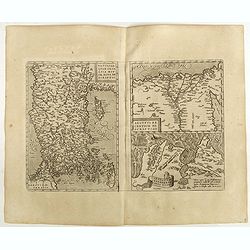
Latium.
Based on classical authors' sources, specifically Virgilius, Plinius, Varro, Halicarnasseus, Festus and Ausonius.Philip Wingius in his letter to Ortelius from 1592 mentio...
Date: Antwerp, 1595

Peregrinatie Jesu Christu Een ordentliche beschrijvinge des Heijligen landts....
Very rare separately map of the Holy Land engraved by Joannes van Doetecum Jr. Oriented to the east. The shoreline runs from "Antaradus" in Syria to "Rhino...
Date: Amsterdam, ca. 1595
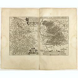
![Blaisois Blesiensis Territorii. . . [together with] - Lemovicum totius et confinium provinciarum. . .](/uploads/cache/28865-250x250.jpg)
Blaisois Blesiensis Territorii. . . [together with] - Lemovicum totius et confinium provinciarum. . .
The map on the left is centered on the Loire with the town of Blois. The right hand map is centered on Limoges.
- $150 / ≈ €127
Date: Antwerp, c. 1595

ABRAHAMUS ORTELIUS ANTVERPIANUS Orteli dum proponis spectantibus Orbem, Quam tua delectant structa Theatra homines! . . .
Portrait of Abraham Ortelius (Abraham Ortel), famous cartographer born in Antwerp and after studying Greek, Latin and mathematics set up business there with his sister, a...
Date: Antwerp, c.1595

Nova et recens emendata totius Regni Ungariae una cum adiacentibus et finitimis regionisbus delineatio.
Engraved map by Jan van Deutecum, here the very rare first edition published by Cornelis Nicola in Amsterdam in 1596. In very attractive original coloring.A re-issued was...
Date: Amsterdam, Cornelius Nicol, 1596
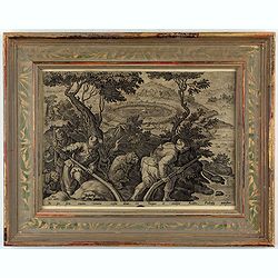
Sic capiunt Ibices iaculo, sic cuspide ferri, / Vel canibus, duro aut flammantis turbinis ictu.
A fine early illustration of capturing a mountain goat hunt. In the left foreground, a group of hunters rest, three dead mountain goats lying beside them; to the right, a...
- $300 / ≈ €255
Date: Antwerp, Philips Galle, ca 1596
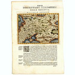
Descrittione Dell'Imperio della MOSCOVIA IMPERIUM.
Uncommon map including Latvia, Livonia, Lithuania, the Ukraine, and northern Part of the Black Sea and the Caspian Sea, Siberia, Georgia, Azerbaijan, Kazakhstan.Giovanni ...
Date: Venice, 1596
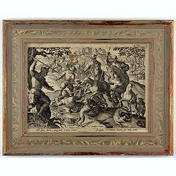
Sic inter dumos, pregrandi corpore cerus. - In pecus extrorquent dumeta per auia, acuto.
This is a plate from a series "Venationes ferarum, avium, piscium, pugnae bestiariorum & mutuae bestiarum". Published by Philippe Galle (Haarlem 1537 - 1612...
Date: Antwerp, Philips Galle, ca 1596
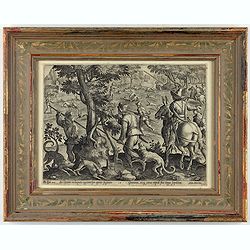
Sic per secta repens venator consista dumis - Torquet et undosos anates, Fusicasp palustres
This is a plate from a series "Venationes ferarum, avium, piscium, pugnae bestiariorum & mutuae bestiarum". Published by Philippe Galle (Haarlem 1537 - 1612...
Date: Antwerp, Philips Galle, ca 1596
Sic leporem in laqueos agitnat per aperta fugacem - Gramina, siq canes rapidi sua terga sequutur
This is a plate from a series "Venationes ferarum, avium, piscium, pugnae bestiariorum & mutuae bestiarum". Published by Philippe Galle (Haarlem 1537 - 1612...
Date: Antwerp, Philips Galle, ca 1596
Piscantur tevetes sinuato in gargite pices.
This is a plate from a series "Venationes ferarum, avium, piscium, pugnae bestiariorum & mutuae bestiarum". Published by Philippe Galle (Haarlem 1537 - 1612...
Date: Antwerp, Philips Galle, ca 1596

Calecuty Regnum
A rare and unusual depiction of the Indian Ocean between Madagascar, Ethiopia, southern Arabia, and south India and Ceylon.The calligraphy is florid and decorative. The e...
- $2000 / ≈ €1700
Date: Cologne, 1596
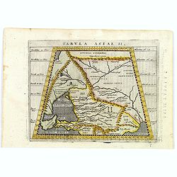
Tabula Asiae II.
A striking example of Magini's map of the Black Sea region from the 1597 edition of Magini's 'Geographia', based upon the work of Claudius Ptolemy. Latin text and tables ...
- $300 / ≈ €255
Date: Venice, 1597
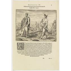
Argumentum IV. Habitus tam magnatum quam plebeiorum descriptus lib. 2 cap. 7. (How the Congolese men dress)
This illustrates the traditional attire worn by the inhabitants of the Congo before the arrival of the Portuguese. The men had small square berets, usually red or yellow,...
- $100 / ≈ €85
Date: Frankfurt, 1598
![Liesena Isola [Hvar]](/uploads/cache/45202-250x250.jpg)
Liesena Isola [Hvar]
Very rare view map of the Island of Hvar published in the first edition of "Viaggio da Venetia, a Costantinopoli. Per Mare, e per Terra, & infieme quello di Terr...
- $400 / ≈ €340
Date: Venice, Giacomo Franco, 1598
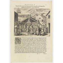
Argumentum I. Primus Lufitanorum cum Sogni praefecto congreffus, eiusdemque Baptismus, de quibus lib. 2 cap 2. fit mentio. (The arrival of the Portuguese in the county Sogno)
The arrival of the Portuguese in the county Sogno. When the Portuguese first discovered the county and the inhabitants of Sogno, they were taken for gods and received wit...
- $100 / ≈ €85
Date: Frankfurt, 1598
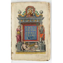
Theatrum Orbis Terrarum.
A Dutch edition of Ortelius' Theatrum Orbis Terrarum "Ghedruckt voor A. Ortelius" (by Corn. Claesz.?), 1598. Illustrated with 92 maps, 91 maps numbered 1-91, in...
- $100000 / ≈ €84988
Date: (Amsterdam, Corn. Claesz.) ?, 1598

Chinae, olim Sinarum regionis. . .
The first printed map of China. It is signed by Ludovico Georgio, whose real name was Luis Jorge de Barbuda. He was a Portuguese Jesuit cartographer and besides that a sp...
Date: Antwerp, 1598
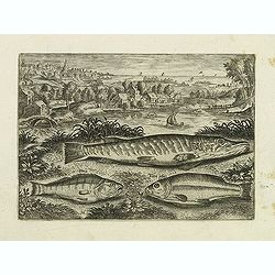
Perca, Tinca piscis. (Piscium Vivæ Icones - Fish)
Depiction of Perca, Tinca piscis. Fish types set against a mountainous landscape in the manner of Pieter Brueghel the Elder. Plate number 16. The engraving is copied afte...
- $200 / ≈ €170
Date: Antwerp, after 1598
Gladius piscis, Galeus piscis, Araneus, Mugil. (Piscium Vivæ Icones - Fish)
Depiction of Gladius piscis, Galeus piscis, Araneus, Mugil. Fish set against a mountainous landscape in the manner of Pieter Brueghel the Elder. Plate number 15. The engr...
Date: Antwerp, after 1598
Faber piscis, Asellus minor, Conger, Alburinus. (Piscium Vivæ Icones - Fish)
Depiction of Faber piscis, Asellus minor, Conger, Alburinus. Fish set against a mountainous landscape in the manner of Pieter Brueghel the Elder. Plate number 14. The eng...
Date: Antwerp, after 1598
Glaucus, Cantharus, Salpa, Rarus. (Piscium Vivæ Icones - Fish)
Depiction of Glaucus, Cantharus, Salpa, Rarus. Fish set against a mountainous landscape in the manner of Pieter Brueghel the Elder. Plate number 12. The engraving is copi...
Date: Antwerp, after 1598
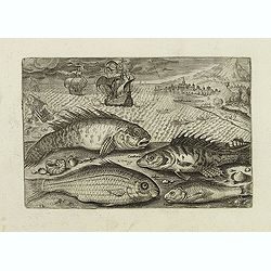
Pusser, Percainus, Salino. (Piscium Vivæ Icones - Fish)
Salmon and other fish set against a mountainous landscape in the manner of Pieter Brueghel the Elder. Plate number 11. The engraving is copied after Adrian Collaert plate...
- $200 / ≈ €170
Date: Antwerp, after 1598
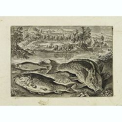
Carpio. (Piscium Vivæ Icones - Fish)
Different types of carp, widespread freshwater fish, are set against a mountainous landscape in the manner of Pieter Brueghel the Elder. Plate number 9. The engraving is ...
- $200 / ≈ €170
Date: Antwerp, after 1598
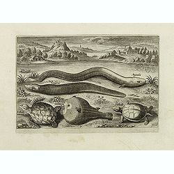
Anguilla, Congrus, Orbis, Tesludo marina, Tesludo. (Piscium Vivæ Icones - Fish)
Blowfish, turtle, eel, etc. set against a mountainous landscape in the manner of Pieter Brueghel the Elder. Plate number 7. The engraving is copied after Adrian Collaert ...
- $200 / ≈ €170
Date: Antwerp, after 1598
Cepola, Rosmarus, Adonis, Hirunda. (Piscium Vivæ Icones - Fish)
Depiction of Cepola, Rosmarus, Adonis, Hirunda, set against a mountainous landscape in the manner of Pieter Brueghel the Elder. Plate number 5. The engraving is copied af...
Date: Antwerp, after 1598
Lampreta, Rayu, Erica, Lira. (Piscium Vivæ Icones - Fish)
Depiction of Lampreta, Rayu, Erica, Lira, set against a mountainous landscape in the manner of Pieter Brueghel the Elder. Plate number 4. The engraving is copied after Ad...
Date: Antwerp, after 1598
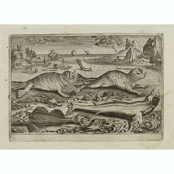
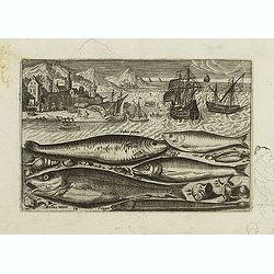
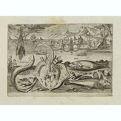
Canis marinus. Cuculus. Silurc (Piscium Vivæ Icones - Fish)
Two seals and fishes, set against a mountainous landscape in the manner of Pieter Brueghel the Elder. Plate number 3. The engraving is copied after Adrian Collaert plate ...
Date: Antwerp, after 1598
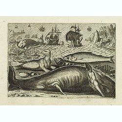
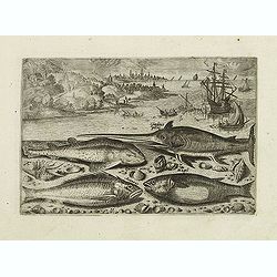
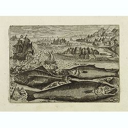
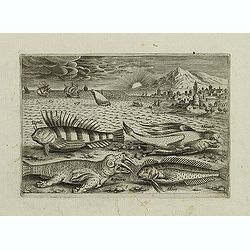
Virulus marinus. Cete (Whale and whaling scene)
Whale and whaling scene, set against a mountainous landscape in the manner of Pieter Brueghel the Elder. Plate number 1. The engraving is copied after Adrian Collaert pla...
Date: Antwerp, after 1598
![[View of Osero].](/uploads/cache/45194-250x250.jpg)
[View of Osero].
Very rare view of Osor published in the first edition of "Viaggio da Venetia, a Costantinopoli. Per Mare, e per Terra, & infieme quello di Terra Santa. Da Giosep...
- $400 / ≈ €340
Date: Venice, Giacomo Franco, 1598
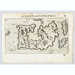
Millo.
Very rare view of Milos Island published in the first edition of "Viaggio da Venetia, a Costantinopoli. Per Mare, e per Terra, & infieme quello di Terra Santa. D...
- $450 / ≈ €382
Date: Venice, Giacomo Franco, 1598
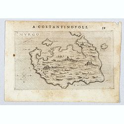
Murgo.
Very rare map of Amorgos published in the first edition of "Viaggio da Venetia, a Costantinopoli. Per Mare, e per Terra, & infieme quello di Terra Santa. Da Gios...
- $300 / ≈ €255
Date: Venice, Giacomo Franco, 1598
![Durazo [ view of Durres in Albania]](/uploads/cache/45212-250x250.jpg)
Durazo [ view of Durres in Albania]
Very rare view of Durres in Albania published in the first edition of "Viaggio da Venetia, a Costantinopoli. Per Mare, e per Terra, & infieme quello di Terra San...
- $450 / ≈ €382
Date: Venice, Giacomo Franco, 1598
![Dulcigno [Ulcinj in Montenegro]](/uploads/cache/45211-250x250.jpg)
Dulcigno [Ulcinj in Montenegro]
Very rare view of Ulcinj in Montenegro published in the first edition of "Viaggio da Venetia, a Costantinopoli. Per Mare, e per Terra, & infieme quello di Terra ...
- $450 / ≈ €382
Date: Venice, Giacomo Franco, 1598
![[ Map with part of Albania]](/uploads/cache/45210-250x250.jpg)
[ Map with part of Albania]
Very rare view of part of the coast of Albania published in the first edition of "Viaggio da Venetia, a Costantinopoli. Per Mare, e per Terra, & infieme quello d...
- $450 / ≈ €382
Date: Venice, Giacomo Franco, 1598
![Budova [Budua in Montenegro]](/uploads/cache/45209-250x250.jpg)
Budova [Budua in Montenegro]
Scarce map centered on Budua in Montenegro was published in the first edition of "Viaggio da Venetia, a Costantinopoli. Per Mare, e per Terra, & infieme quello d...
- $450 / ≈ €382
Date: Venice, Giacomo Franco, 1598
![Glissa. [Klissza or Klis]](/uploads/cache/45203-250x250.jpg)
Glissa. [Klissza or Klis]
Very rare view of Klissza (Klis) published in the first edition of "Viaggio da Venetia, a Costantinopoli. Per Mare, e per Terra, & infieme quello di Terra Santa....
- $300 / ≈ €255
Date: Venice, Giacomo Franco, 1598
![Spalato [ View of Split]](/uploads/cache/45201-250x250.jpg)
Spalato [ View of Split]
Very rare view of Split published in the first edition of "Viaggio da Venetia, a Costantinopoli. Per Mare, e per Terra, & infieme quello di Terra Santa. Da Giose...
- $450 / ≈ €382
Date: Venice, Giacomo Franco, 1598
![Plants found in the island of S. Laurenti [Madagascar].](/uploads/cache/41368-250x250.jpg)
Plants found in the island of S. Laurenti [Madagascar].
‘ A’ denotes a tree with only a few twigs on the top. From this tree, canoes and boats are made. ‘B’ is a bush that the Dutch frequently encountered and was calle...
- $80 / ≈ €68
Date: Frankfurt, 1598

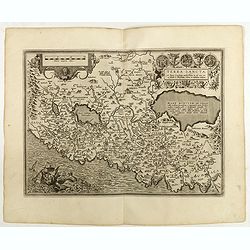
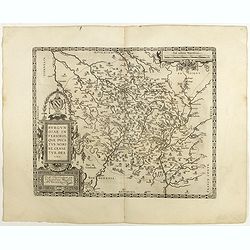
Artois. Atrebatum Regionis Vera Descripto.
Prepared by Jacob Surhon, who made a manuscript map of Artois for which he received 36 Livres from Charles V in 1554. For security reasons, the map was not published. Onl...
Date: Antwerp, 1598

Romaniae, (quae olim Thracia dicta) ..
Very fine map centered on the Danube area. The map is based on the double sheet map by Jacob Gastaldi. Abraham Ortelius (1527-1598) was a cartographer and publisher, who ...
Date: Antwerp, 1598
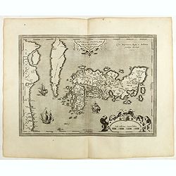
IAPONIAE INSULAE DESCRIPTIO.Ludoico Teisera auctore.
The map was based upon the manuscript draft supplied to Ortelius in about 1592 by the famous official Portuguese chart maker, Luis Teixeira , who was the cartographer t...
Date: Antwerp, 1598
Terra Sancta A Petro Laicstain perlustrata, et ab eius ore
Oriented to the east. Shows the shoreline from Beirut to Gaza. P. Laicksteen, a Dutch astronomer… collected topographic material on Palestine during his stay there in 1...
Date: Antwerp, 1598
Natoliae Quae Olim Asia Minor, Nova de Scriptio / Carthaginis Celeberrimi Sinus Typus / Aegypti re Centior de Scriptio
Three detailed regional maps by Ortelius from his "Theatrum Orbis Terrarum", the world's first modern atlas.The first map covers Asia Minor, Cyprus and the East...
Date: Antwerp, 1598
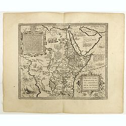
Presbiteri Johannis, sive Abissinorum Imperii descriptio.
Depicting Africa from the Mediterranean to the Mountains of the Moon placed just below Mozambique. Dare to go in Black. All early maps were printed in black and white,...
Date: Antwerp, 1598

Barbariae et Biledulgerid, nova descriptio.
North-West Africa. Koeman speculated: "In view of the important trading relationship between Antwerp and Africa, it is not impossible that the original was a manuscr...
Date: Antwerp, 1598
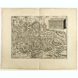
Moraviae.
This early map of Slovakia was prepared by Paul Fabritius in 1569, centered on the city of Brno. Title cartouche on the upper left corner. Abraham Ortelius (1527-1598) wa...
Date: Antwerp, 1598

Silesiae typus..
Fine and early map of Silesia after Martin Helwig (1516-1574) and used by A.Ortelius in his atlas 'Theatrum Orbis Terrarum [Atlas of the Whole World].Only included in the...
Date: Antwerp, 1598
Helvetiae Descriptio . . .
A fine map based upon a map by the Swiss cartographer Aegidicus Tschudi of 1538.Dare to go in Black. All early maps are printed in black and white and many were kept that...
Date: Antwerp, 1598

Florentini Dominii Fidelissima et nova descriptio.
The map is centered on the city of Florence and extends to Liguria, the Apennine Mountains, the Adriatic Coast, Siena and Lago di Perugia. The map is based upon Stefano B...
Date: Anvers, 1598
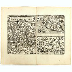
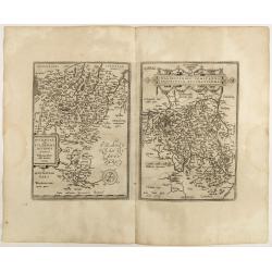
Carinthiae et Goritiae .. / Histria / Zarae / Serebenici. . .
Three maps on one sheet. The left-hand is centered on the eastern part of Austria. The upper right-hand map is centered on northern Yugoslavia, and the last map is center...
Date: Antwerp, 1598
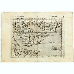
Arabia Felice Nuova Tavola.
Fine early map of Arabian peninsula, being one of the earliest modern maps of the region.Girolamo Ruscelli first published the map in his "La Geographi di Claudio To...
Date: Venice, 1598
Mansfeldiae Comitatus.
A very fine map centered on the city of Mansfelt . A very nice title cartouche in the upper right corner. Signed by the engraver Franz Hogenberg lower left. Abraham Ortel...
- $75 / ≈ €64
Date: Antwerp, 1598
Basiliensis territorii descriptio nova./Circulus sue Liga. . .
Left-hand map centered on Basel, east to top. With credit to Sebastian Münster in the title cartouche. Right-hand map with Boden See, Strasbourg and Augsburg. The map wa...
- $300 / ≈ €255
Date: Antwerp, 1598
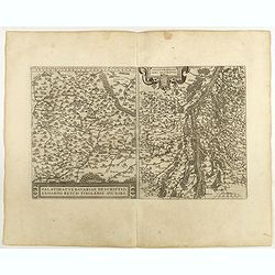
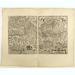
Palatinatvs Bavariae . . . / Argentoratensis agri . . .
From 'Theatrum Orbis Terrarum [Atlas of the Whole World]. The left-hand map of Bavaria is after Erhart Reych's 4-sheet map of 1540. Including the towns of Regensburg, Nü...
- $100 / ≈ €85
Date: Antwerp, 1598
![Larii Lacus Vulgo Comensis Descriptio . . . [and] Terretorii Romani Descrip. [and] Fori Iulii Vulgo Frivli Typus. . .](/uploads/cache/41008-250x250.jpg)
Larii Lacus Vulgo Comensis Descriptio . . . [and] Terretorii Romani Descrip. [and] Fori Iulii Vulgo Frivli Typus. . .
Set of 3 maps on one sheet of Lake Como, the region around Rome and the region around the Upper Adriatic, centered on Udinese from 'Theatrum Orbis Terrarum [Atlas of the ...
Date: Antwerp, 1598
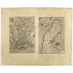
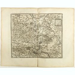
Patavini territorii../ Tarvisini agri typus.. (2 maps on one sheet)
Two maps on one sheet. Map to the left is a detailed map including Venice and the area north of it, including Padua and Vincenza. Very fine map after Giacomo Gastaldi. Th...
- $300 / ≈ €255
Date: Antwerp, 1598
Birds and fish seen during the voyage to India.
During their voyage to India many strange birds were seen, for example, the 'Garayos' that were the size of a chicken, the 'Rabos de Juncos' that are white and about the ...
- $100 / ≈ €85
Date: Frankfurt, 1598
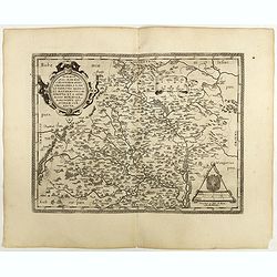
Buchaviae / Waldeccensis Comitatus.
Two maps on one sheet. The map on the left is based on Wolfgang Regerwyl's 1574 single fulda map. The map of Waldeck is based on Joist Moers map of 1572. Abraham Ortelius...
- $100 / ≈ €85
Date: Antwerp, 1598
Braunsvicensis et Luneburgensis . . . (together with) Norimberg Agri,..
Two maps on one sheet, showing the regions of Braunschweig and Nuremberg from 'Theatrum Orbis Terrarum [Atlas of the Whole World]': published in Antwerp.Dare to go in Bla...
- $125 / ≈ €106
Date: Antwerp, 1598

India Tercera Nuova Tavola.
The 1598 edition of this early map of South East Asia. Just to the west and south of Malacca one will notice ‘Camatra’ (Sumatra) and Java. China with Canton in the up...
Date: Venice, 1598
Burgundiae inferioris quae Ducatus Nomine Censetur, Des.
Map centered on the province of Burgundy, from 'Theatrum Orbis Terrarum'.Dare to go in Black. All early maps were printed in black and white; many were kept that way for ...
- $100 / ≈ €85
Date: Antwerp, 1598
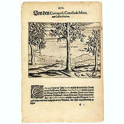
The carcapuli, canella de mato and cassia solutiva.
The ‘caarcapuli’ that grows on the island of Sunda is a tasty, cherry-sized fruit. The Canella de mato that grows in abundance in the forests of Java is wild cinnamon...
- $80 / ≈ €68
Date: Frankfurt, 1598
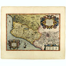
Hispaniae novae sive magnae recens et vera descriptio. 1579
This was the standard map of the area for a generation, copied by De Bry, Quad and Hondius. Even though Herrera (Spain's Royal Cosmographer) and Wytfliet worked 20 years ...
Date: Antwerp, 1598
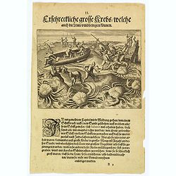
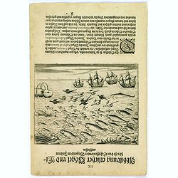
The Dutch are attacked by giant crabs.
During their return voyage, the Portuguese were wrecked on a sandbank (the Seychelles?) From the debris they began building a smaller ship in which they hoped to return t...
Date: Frankfurt, 1598
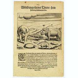
Some of the animals that are found in India.
Although most elephants are found in Ethiopia, there are also many in India too. They are called 'Caffres' by the inhabitants and are slaughtered for their tusks, which t...
Date: Frankfurt, 1598
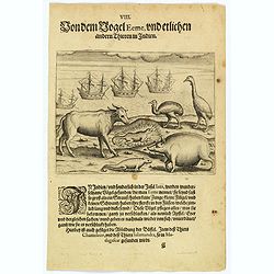
The bird called 'Eeme' and other creatures of India.
Especially on the island of Java and in India, a strange bird called an 'Eeme' is found. It is almost as large as an ostrich with strong and sturdy legs, but it has no to...
Date: Frankfurt, 1598
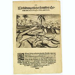
Plants, including the canior, diringuo, pucho and chiabe.
In the Indies there are many delightful plants, which include the ‘costus indicus’ (named by the Malays 'pucho') that has a wonderful aroma. Then there is the ‘cala...
Date: Frankfurt, 1598
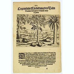
A picture of various trees including the palm tree.
The Jacca fruit grows only on the trunk of the tree, not on its branches, rather like the fruit of the palmates. Then there is a fruit that grows in abundance in Bali, wh...
- $80 / ≈ €68
Date: Frankfurt, 1598
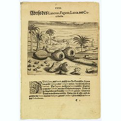
Illustrations of Lancuas, Fagaras, Lacca and Cuci fructa.
Common in Bali, Java and Sunda is a plant known as the great Galanga or Galigam. The natives, however, call it Lancuas. The fagaras, particularly found in Sunda, looks li...
- $80 / ≈ €68
Date: Frankfurt, 1598
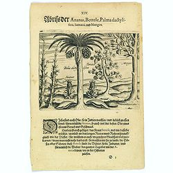
Pineapple, Bettel, palma dactylifera, Samaca & Mango.
These are all Indian fruits, of which the pineapple has the best flavour and aroma. The Bettel plant is also shown here climbing up long rods and canes, just as the peppe...
- $100 / ≈ €85
Date: Frankfurt, 1598