Browse Listings in Map Types > Asian Made Maps & Items
![Bunken Edo oezu. [Tokyo]](/uploads/cache/12826-250x250.jpg)
Bunken Edo oezu. [Tokyo]
Based on map by Ochikochi Doin. Oriented with north to the right. An extraordinary wood block-printed town-plan now-a-day Tokyo, and a fine example of Edo cartography. Th...
Place & Date: Edo, ca. 1803
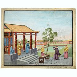
Chinese Export watercolor.
Chinese watercolor with in lower margin Chinese text : Chinese watercolor - " A farmer's thief, a book, a big manuscipt, a filial piety, a martial art. " [Googl...
- $1000 / ≈ €936
Place & Date: China, ca. 1850
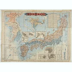
Kaisei dosen Dai Nihon yochi zenzu.
Title in top : "Dai Nihon yochi zenzu.". Showing Japan, Korea and in an inset Hokkaido. Folding copperplate print in Japanese. Relief shown by hachures. Include...
- $350 / ≈ €328
Place & Date: Tokyo, Meiji 10 or 1877
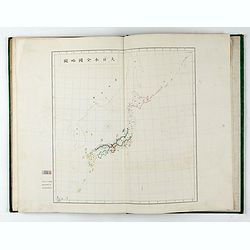
内務省地理局 (Administratif atlas of the Empire of Japan.)
Atlas of Japan published by the Home Ministry shortly after the start of Meiji period. The atlas contains 16 double page maps, with the border in original out line colors...
- $550 / ≈ €515
Place & Date: Tokyo, Meiji 14 or 1881
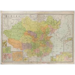
New China Map.
Very large and detailed map of China (1:6,000,000) printed in Shanghai, June 27th 1938 by JIN-SHIN GEOGRAPHICAL INSTITUTE.The title and place names in Chinese and Engli...
- $900 / ≈ €842
Place & Date: Shanghai, June 27th 1938