Search Listings matching "propaganda-war-maps"
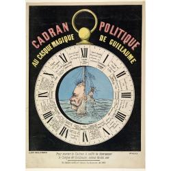
Cadran Politique au casque magique de guillaume.
A rare broad sheet about the Franco-Prussian War. Showing a large clock with in the center William I, the German Emperor, surrounded by 12 stages of the war.Printed by Gi...
Place & Date: Paris, c.1872

A Humorous Diplomatic Atlas of Europe and Asia. / 滑稽欧亜外交地図 / Kokkei Ō-A Gaikō Chizu.
A wonderful example of the rare 1904 Kisaburo Ohara satirical 'Octopus Map' of Europe being swallowed by an octopus (Russia). Composed at the outbreak of the Russo-Japane...
Place & Date: Tokyo, April, 1904
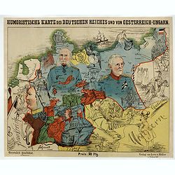
Humoristische Karte von Europa im Jahre 1914.
A satirical map of Europe with a title in German that marks the outbreak of the First World War, probably conceived between August and October 1914. Lehmann-Dumont was no...
Place & Date: Dresde, Leutert & Schneidewind, ca. 1914

Karte von Europa im Jahre 1870 nach einem französischen Holzschnitte.
Satirical illustration by Paul Hadol showing disposition of power in Europe at the beginning of 1870. Satirical print depicting a map of Europe in which the countries are...
Place & Date: Hamburg, Fuchs, 1914

Völker Europas wie schön sind eure Geschichter. (World War I post card)
During the Great War, when the only means of communicating news to the masses was by newspapers and weekly illustrated magazines, the ‘war’ or 'military' picture post...
Place & Date: Germany, 1915
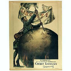
3e emprunt de la Défense nationale Crédit Lyonnais. Souscrivez.
Large color lithographed propaganda World War 1 poster. Designed by the illustrator Faivre Abel (1867-1945). A solder placing the French flag on a globe.English translati...
Place & Date: Paris, 1917

Histoire Socialiste.
Text includes “Imp. Centre de Propagande, des Républicains Nationaux, 102, rue Amelot, Paris (XIe), ou l’on peut se procurer cette affiche. Cette affiche ne peut êt...
Place & Date: Paris, 1931
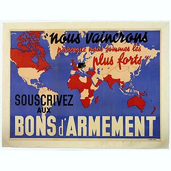
Nous vaincrons parce que nous sommes les plus forts. Souscrivez aux bons d'armement.
"We win because we are the strongest. Support good armaments". Quote by the French Prime Minister Paul Reynaud. French wartime propaganda poster. color printed ...
Place & Date: Paris, M.Dechaux, ca 1939
Selling price: $105
Sold in 2019

L'Europe en Sept 1939. Ille terrarum mihi angulus ridet.
A rare oversized serio-comic map of Europe at the start of the Second World War depicting stereotypes of 31 countries, as listed in the key lower right, including Brit...
Place & Date: Bruges, Leon Burghgraeve, 1939

Ce que les Anglo-Saxons ont perdu en Extrême-Orient.
Illustrated Vichy propaganda War & Propaganda poster showing a map of South East Asia, with Indonesia, Philippines, Thailand, etc., among photos and explanations abou...
Place & Date: Paris, 1943
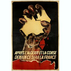
Après l'Algérie et la Corse Demain se sera la France.
Anti-Communist propaganda poster, realised by the French Vichy Government and the Germans in January 1944. Propaganda hostile to the liberators playing on the fears of th...
Place & Date: Paris, 1944
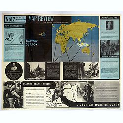
Map Review No.17. Eastwood Outlook.
A large double sided 'current affairs' poster. One side features a eastern hemisphere world map, and deals with matters arising in South East Asia, the Far East and Europ...
- $180 / ≈ €156
Place & Date: London, 1946
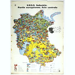
U.R.S.S. Industrie. Partie européenne, Asie centrale. (3)
Map of Eastern Russia. Propaganda poster for Russia's industry. Text in French. Editions de l'Agence de presse Novosti".More about War Maps & Propaganda maps [+]
- $100 / ≈ €87
Place & Date: USSR, 1978