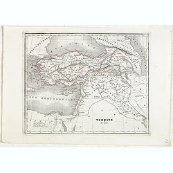
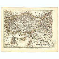
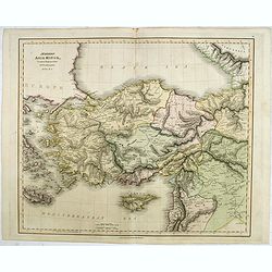
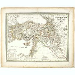
Turquie d'Asie.
Detailed map of Asian Turkey with Cyprus, prepared by Charles V. Monin (fl.1830-1880) a French cartographer of Caen and Paris. Published in Atlas Universel de Géographie...
- $45 / ≈ €42
Place & Date: Paris, 1845
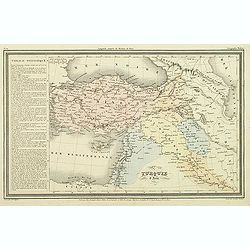
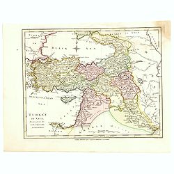
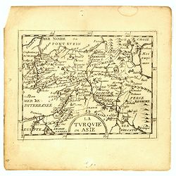
Turquie d'Asie.
Finely engraved map of Turkey, Cyprus, Palestine, Kurdistan and Iraq, prepared by A.H.Dufour and engraved by Giraldon-Bovinet. Published by Jules Renouard in his uncommon...
- $50 / ≈ €47
Place & Date: Paris, Jules Renouard, ca.1840
![[Asia Minor]](/uploads/cache/35958-250x250.jpg)
[Asia Minor]
Early, attractive woodcut map of Turkey, with Cyprus shown in the lower right corner. On the full sheet with German text beneath and verso. From the German edition of Seb...
- $50 / ≈ €47
Place & Date: Basle, 1584
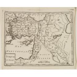
Turquie d'Asie.
Map of Turkey, including Cyprus and part of the Near East. From Atlas de la Géographie de toutes les parties du monde.. Ouvrage destiné pour l'education, et nécessaire...
Place & Date: Paris, Prudhomme, Levrault, Debray, 1806
Az Europai és Asiai Torok Birodalom Kozonséges Foldképe
Hungarian map of Turkey, including Greece, Cyprus, etc.
- $150 / ≈ €140
Place & Date: Pesten, 1864
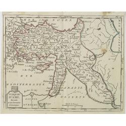
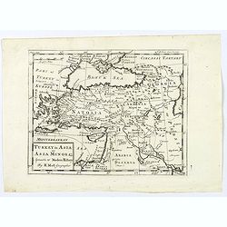
Turkey in Asia.
An attractive map covering Asia Minor, Syria, Armenia, Georgia, Kurdistan, Iraq, Syria, Cyprus and the Black Sea. Shows towns, rivers, mountains, lakes, etc. In pretty or...
- $65 / ≈ €61
Place & Date: London, 1794
Turquie d'Asie . . .
Map of Turkey, including Cyprus, Palestine, etc. , from Atlas moderne portatif composé de vingt-huit cartes sur toutes les parties du globe terrestre .. A l'usage des Co...
- $100 / ≈ €94
Place & Date: Paris, Prudhomme, Levrault, Debray, 1806
Die Asiatische Turkey 1854.
Steel engraved map, hand colored in outline when it was published. The detailed map shows the Asian part of Turkey, most of Syria, Iraq, Cyprus and the southern reaches o...
- $70 / ≈ €66
Place & Date: Hildburghausen, Bibliograph Institut,1854
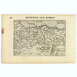
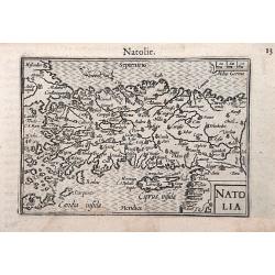
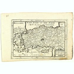
Natolia.
A miniature map of Turkish Natolia, published by Petrus Bertius in Amsterdam, at the beginning of the seventeenth century. This attractive small map features hatching in ...
- $150 / ≈ €140
Place & Date: Amsterdam, 1606
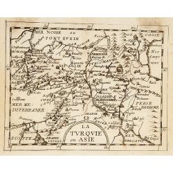
La Turquie en Asie.
Uncommon miniature map of Turkey, Cyprus, Palestine, Iran, and Iraq. From Pierre Duval's "La Geographie Universeille" dated 1676. Following his "Cartes de ...
- $75 / ≈ €70
Place & Date: Paris, 1676
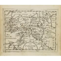
La Turquie en Asie.
Uncommon miniature map of Turkey, Cyprus, Palestine, Armenia, Iran and Iraq. From Pierre Duval's La Geographie Universeille dated 1676. Following his Cartes de geographie...
- $90 / ≈ €84
Place & Date: Paris, 1676
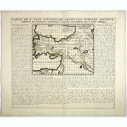
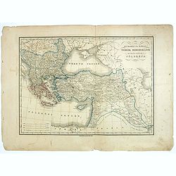
Carte De L'Asie Inferieure Selon Les Auteurs Anciens, Enrichie de Remarques Historiques sur les Changemens qui y sont arrivez.
Text page with inset map (220x269.mm.) of Turkey, including Cyprus from Chatelain's monumental 7 volume "Atlas Historique". Henri Abraham Chatelain (1684 – 17...
- $200 / ≈ €187
Place & Date: Amsterdam, 1720
Natolia.
A miniature map of the Arabian peninsula, including Cyprus. The title cartouche on the lower right corner.First published in 1598 in his Caert-Thresoor, the plates were e...
- $200 / ≈ €187
Place & Date: Amsterdam / Frankfurt, 1609
Modern Asia Minor. Drawn & Engraved for Dr. Playfair's Geography.
Detailed map of Black Sea, Cyprus and Turkey engraved by Samuel John Neele (1758-1824) and published by Alexander Macredie. Originally engraved for James Playfair's "...
- $175 / ≈ €164
Place & Date: London / Edinburgh, 1824
La Turquie en Asie.
Uncommon miniature map of Turkey, Cyprus, Palestine, Iran, Iraq. From Pierre Duval's "La Geographie Universeille" dated 1676. Following his "Cartes de geog...
- $100 / ≈ €94
Place & Date: Paris,1676

Anamu Buru to Latakia including Iskenderun Körfezi.
A highly corrected version of Admiralty chart 2632 originally published 25 November 1955 under the Superintendence of Captain K.SB. Collins. Edition Date 1984 Detailed ch...
- $100 / ≈ €94
Place & Date: London, 1955 - 1984
Turkey in Asia: or Asia Minor &c.
Herman Moll's map of the Turkish Empire in Asia, published in London during the first half of the eighteenth century. It shows the eastern Mediterranean, including Crete ...
- $150 / ≈ €140
Place & Date: London, ca 1729
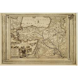
Turquie en Asie, suivant les nouvelles observations..
Uncommon edition of this map of Turkey, Holy Land, Armenia, including Cyprus. With decorative title cartouche lower left corner.This example is unusual in having the addi...
- $200 / ≈ €187
Place & Date: Leiden, 1728
Das Osmanische asien oder die Asiatische Türkey. . .
Decorative map showing 'Asia Minor' with its neighboring countries. Prepared by Karl Ferdinand Weiland The eastern part of the Mediterranean Sea with Cyprus is as well sh...
- $200 / ≈ €187
Place & Date: Weimar, 1836-1838
Natolie ou Asie mineur, Lieües d'Alemag.
Rare map of Turkey and Cyprus published by Jollain in 1667. Published in "Trésor Des Cartes Geographiques Des Principaux Estats de Lunivers".This atlas is base...
- $250 / ≈ €234
Place & Date: Paris, 1667
![[Map of Turkey]](/uploads/cache/31502-250x250.jpg)
[Map of Turkey]
Page with an early representation of Turkey with Cyprus and Syria. This text page with a fine wood block printed map is from the rare work "C. Iulii Solini Polyhisto...
- $275 / ≈ €257
Place & Date: Basle, Michael Isengrin, 1544
Natoliae Sive Asia Minor.
From the first edition. Map of Turkey, also depicting Cyprus.
- $350 / ≈ €328
Place & Date: Amsterdam, 1606
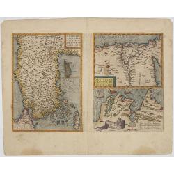
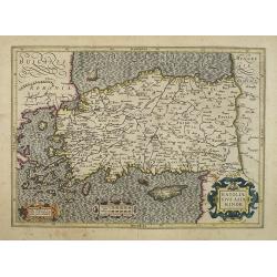
Natoliae.. Aegypti recentior.. Carthaginis (3 maps on 1 sheet)
Map to the left east to the top. Detailed map Turkey, including Cyprus and Crete. Also map of the Nile delta and another map of Tunis. From "Theatrum Orbis Terrarum&...
- $500 / ≈ €468
Place & Date: Antwerp, 1609-1641
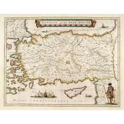
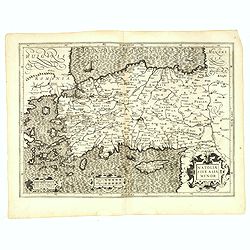
Natolia, quae olim Asia minor.
A finely designed map of Turkey and Cyprus from the great Blaeu family of Amsterdam. The decoration consist of a colored title cartouche, sea monsters, a naval engagement...
Place & Date: Amsterdam, 1635
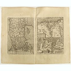
Natoliae Quae Olim Asia Minor, Nova de Scriptio / Carthaginis Celeberrimi Sinus Typus / Aegypti re Centior de Scriptio
Three detailed regional maps by Ortelius from his "Theatrum Orbis Terrarum", the world's first modern atlas.The first map covers Asia Minor, Cyprus and the East...
Place & Date: Antwerp, 1598
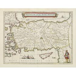
Natolia, quae olim Asia minor.
A finely designed map of Turkey and Cyprus from the great Blaeu family of Amsterdam. The decoration consist of a colored title cartouche, sea monsters, a naval engagement...
- $450 / ≈ €421
Place & Date: Amsterdam, 1658
Natoliae Sive Asia Minor.
Map of Turkey, also depicting Cyprus.
- $750 / ≈ €702
Place & Date: Amsterdam, 1610
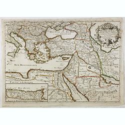
L'Empire des Turcs en Europe, en Asie et en Afrique.
A nice map showing the Turkish Empire, including an inset map of kingdom of Alger. Extending from Italy and the Eastern Mediterranean in the west to the Caspian Sea and P...
- $550 / ≈ €515
Place & Date: Paris, 1686

Natoliae.. Aegypti recentior.. Carthaginis ( 3 maps on 1 sheet)
Three maps on one sheet. Map to the left east to the top. Detailed map Turkey, including Cyprus and Crete. Also map of the Nile delta and another map of Tunis. From "...
- $750 / ≈ €702
Place & Date: Antwerp, 1587

A Map of the Environs of Constantinople Drawn from a great number of accurate astronomical & geographical manuscripts and printed documents, by A. Arrowsmith 1801 and 1804.
Arrowsmith’s large and detailed map of the Ottoman Empire and the Black Sea, with Cyprus, Crete and the Greek Islands in the Mediterranean Sea, Albania, Bosnia and Herz...
Place & Date: London, No.10 Soho Square, 4th September 1804