Browse Listings in Europe > Spain > Spain General Maps
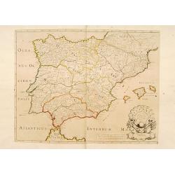
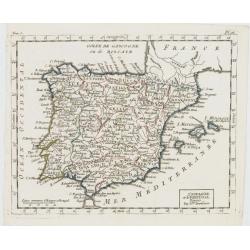
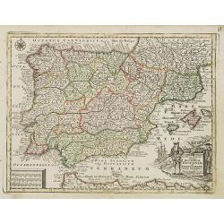
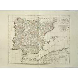
Hispaniae Antiquae Tabula.
A fine map of ancient Spain, Portugal and Majorca, etc.This edition carries the date 1641 and in manuscript pencil 1690.Nicolas Sanson was to bring about the rise of Fren...
- $200 / ≈ €187
Place & Date: Paris, 1641-1690
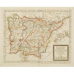
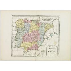
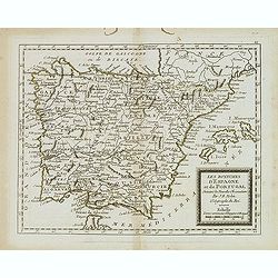
Les Royaumes d'Espagne et de Portugal ..
Rare map of Spain and Portugal prepared by J.B.Nolin and published by Monhare for his Atlas Général a l'usage des colleges et maisons d'education.. Louis Joseph Mondhar...
- $120 / ≈ €112
Place & Date: Paris, 1783
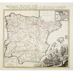
Hispania Benedictina, seu Monasteria et alia pia loca Ord. S. Benedicti ..
Map of the Iberian Peninsula and an inset map of South America with all the monasteries and holy places of the Benedictine order, compiled by the Benedictine friar Rupert...
Place & Date: Nuremberg 1750
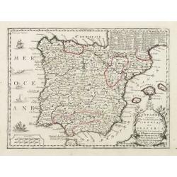
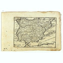
L'Espagne nominée Par les Anciens Grecs Iberia ou Hesperia..
Lovely small map of Spain with decorative title cartouche, vessels and a sea monster in the Atlantic Ocean.Presenting a panel in the upper right corner listing local rule...
Place & Date: Paris, 1719
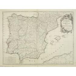
L'Espagne et le Portugal. Divisés Par Gdes. Provinces.
Map of Spain and Portugal, including the Balearic Islands archipelago. From Atlas de la Géographie de toutes les parties du monde .. Ouvrage destiné pour l'education, e...
- $80 / ≈ €75
Place & Date: Paris, Prudhomme, Levrault, Debray, 1806
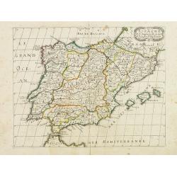
Hispania Antiqua in tres praecipuas partes..
Map of the Hibernia peninsula and the Balearic Islands. With a rococo title cartouche in the lower right corner.Venetian edition of Giles Didier Robert De Vaugondy's map ...
Place & Date: Venice, 1776 - 1784
Les Royaumes d'Espagne et de Portugal, divisés Par Grandes Provinces..
Attractive map of the Iberian Peninsula. Ornated with a decorative title cartouche showing the coats of arms of Spain and Portugal.Prepared by Le Sieur Janvier, Jean deni...
- $200 / ≈ €187
Place & Date: Venice, 1776 - 1784
Espagne. . .
Map of Spain and Portugal prepared by N.Sanson and published by Pierre Mariette.Published in an early edition of the small Sanson atlas L'Europe Dediée a Monseigneur . ....
Place & Date: Paris, P. Mariette, 1667
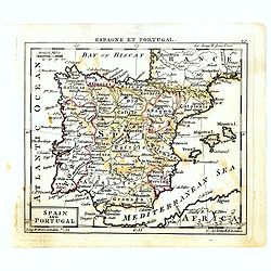
Novillinta et accura tilsnia Regnorum Hispaniae et Portugalliae. . .
Miniature map of Spain and Portugal, a reduction of the Seutter''s folio map.From Atlas Minor, here published by Johann Martin Will, with his address in bottom center of ...
- $200 / ≈ €187
Place & Date: Augsburg, J.M.Will, 1778
Royaumes d'Espagne et du Portugal.
Map of Spain and Portugal. By C. F. Delamarche, successor of Robert de Vaugondy, Geographer.
- $80 / ≈ €75
Place & Date: Paris, 1794 - 1806
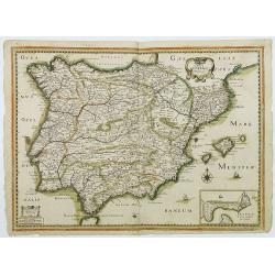
Carte generale d'Hespagne.
Rare map of Spain and Portugal from "Theatre des Gaules". In lower right corner a little inset of Cadiz.Very rare in original color.
- $750 / ≈ €702
Place & Date: Paris, 1637
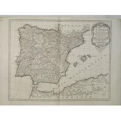
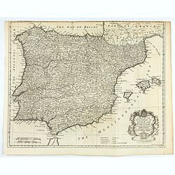
Carte de l'Espagne Dressée par Guillaume Delisle sur la description de Rodrigo Mendez Sylva . . .. Le tout augmenté et vérifié en 1789. Par Phil. Buache, de l'Académie des Sciences.
Map of Spain published at the outbreak of the French Revolution. Taken from the Atlas Géographique.. published by Dezauche, as successors to De l'Isle & Buache. Publ...
- $150 / ≈ €140
Place & Date: Paris, 1789
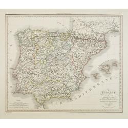
Carte de l'Espagne Dressée par Guillaume Delisle sur la description de Rodrigo Mendez Sylva . . .. Le tout augmenté et vérifié en 1789. Par Phil. Buache, de l'Académie des Sciences.
Map of Spain and Portugal, including the North African coast and good detail for Majorca, Minorca and Ibiza. Published by Dezauche at his address Rue de Sorbonne, n°9, a...
- $200 / ≈ €187
Place & Date: Paris, 1827
L' Espagne et le Portugal . . .
Map of Spain and Portugal, from Atlas moderne portatif composé de vingt-huit cartes sur toutes les parties du globe terrestre .. A l'usage des Colléges, des Pensions &a...
Place & Date: Paris, Prudhomme, Levrault, Debray, 1806
Espagne et Portugal . . .
Detailed map of Spain and Portugal, Majorca and Minorca, etc., prepared by A. H. Basset, rue Saint-Jacques, no. 64, Paris and published in Atlas Classique et Universel de...
- $100 / ≈ €94
Place & Date: Paris, A.H. Basset, 1828
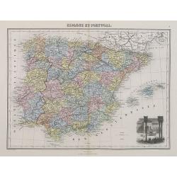
Espagne et Portugal.
A decorative map of Spain and Portugal from Géographie Universelle, Atlas Migeon. With an engraving of the Alhambra in the lower right corner. Published by J. Migeon. Fr...
- $35 / ≈ €33
Place & Date: Paris, 1874
Hispaniae nova describtio. . .
Map of Spain and Portugal. Engraved by Petrus Kaerius.
- $750 / ≈ €702
Place & Date: Amsterdam, 1628
Carte géographique, physique et politique des royaumes d'Espagne et de Portugal indiquant les chemin fer en exploitations, ceux en cours d'éxécutions
Very large, highly detailed and uncommon map of Spain, Portugal and the northern coast of Africa. The map shows according to the title: rail roads, main interregional rou...
Place & Date: Paris, c.1867
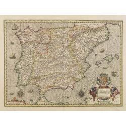
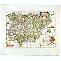
Nova et accurata Tabula Hispaniae. . .
Second state. This "carte à figures"- map of Spain and Portugal shows the geographical image introduced by Hessel Gerritsz's 1612 wall map of Spain. The map is...
Place & Date: Amsterdam, 1633
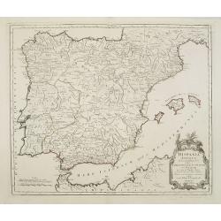
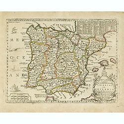
Parte Orientale della Spagna. . .
A scarce and very attractive double sheet detailed map of Spain and Portugal. This map appeared in the "Atlante Veneto", Coronelli's best known work. In a typic...
Place & Date: Venice, 1696
Les royaumes d'Espagne et de Portugal. . .
Scarce map of Spain and Portugal prepared by Nolin and published by L.J. Mondhare for his Atlas Général a l'usage des colleges et maisons d'education.. Louis Joseph Mon...
- $100 / ≈ €94
Place & Date: Paris, 1783
![L'Espagne subdivisée en tous ses royaumes, princip[au]tés, seign[eu]ries. . .](/uploads/cache/33236-250x250.jpg)
L'Espagne subdivisée en tous ses royaumes, princip[au]tés, seign[eu]ries. . .
Map of Spain, Portugal, Majorca and Minorca with original outline hand-color. Numerous place-names of counties, cities, towns, physical features.
- $400 / ≈ €374
Place & Date: Paris, 1663
Karta öfver Spanien och Portugal.
An very rare map of Spain and Portugal with Swedish text. This is an updated version of his map of 1819 and is now dated 1833.From his atlas "Geographisk Hand-Atlas&...
- $100 / ≈ €94
Place & Date: A. Wiborgs förlag, Stockholm, ca. 1848

Tabula Secunda Europe (Spain & Portugal)
Wood block printed large-format Ptolemaic map of the Iberian Peninsula from the 1513 edition of Waldseemüller's Geographia.This Ptolemaic map comes from the first so cal...
Place & Date: Strasburg, 1513
L'Espagne nominée Par les Anciens Grecs Iberia ou Hesperia. . .
Lovely small map of Spain with decorative title cartouche, vessels and a sea monster in the Atlantic Ocean.Presenting a panel in the upper right corner listing local rule...
- $150 / ≈ €140
Place & Date: Paris, 1719
Hispania.
Small map of the Iberian peninsula with the Balearic Islands, surrounded by text in Dutch.Nicolaes de Clerck (de Klerc) was active as an engraver and publisher in Delft f...
- $100 / ≈ €94
Place & Date: Amsterdam, Cloppenburch, 1621
Spain and Portugal.
Uncommon miniature map of Spain and Portugal, engraved by Thomas Kitching for "A New General and Universal Atlas Containing Forty five Maps by Andrew Dury".This...
- $60 / ≈ €56
Place & Date: London, 1761-1763
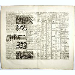
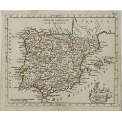
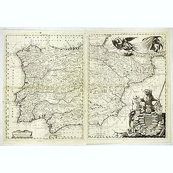
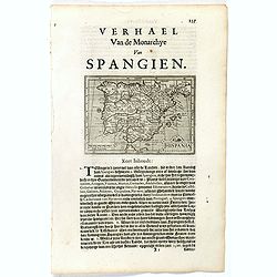
Carte du Gouvernement de la Cour d'Espagne. . .
Engraved text sheet, providing a detailed description of the infrastructure of Spain's ecclesiastical and military government as well as information listed in a lengthy t...
- $75 / ≈ €70
Place & Date: Amsterdam, ca. 1720
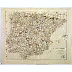
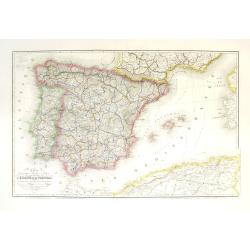
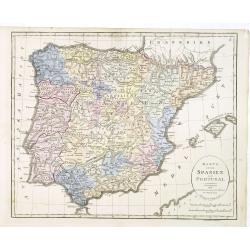
Spain & Portugal.
A large steel engraved map of European neighbours of Spain and Portugal. Including Balearic Islands, with a further inset map of Minorca. Numerous place names and physica...
Place & Date: London, 1839
Espagne.
Rare map of Spain and Portugal, published by Jollain in 1667. Published in "Trésor Des Cartes Geographiques Des Principaux Estats de Lunivers".This atlas is ba...
- $200 / ≈ €187
Place & Date: Paris, 1667
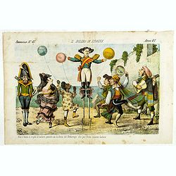
Il bolero in Ispagnia. Papagallo No. 42. Anno VI.
About Spanish expansion, with balloons symbolizing Cuba, Havana, Cortes. Taken from the Italian satirical newspaper Il Papagallo, a satirical magazine founded in January ...
Place & Date: Bologne, 1878
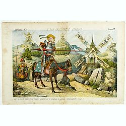
Il Don Cihsciotte a complici. Papagallo No. 48. Anno VI.
Taken from the Italian satirical newspaper Il Papagallo, a satirical magazine founded in January 1873 by Augusto Grossi (1835-1919), which specialized in color-printed ca...
Place & Date: Bologne, 1878
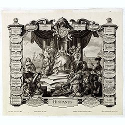
Hispanus.
Allegorical print of Spain (Hispanus), copper engraving after P. Decker by M. Engelbrecht. Taken from "Laconicum Europae Speculum". Philippe Andrea Kilian (1714...
Place & Date: Augsburg, 1737
Circoscrizione delle province ecclesiastiche e Diocesinei regni di Spagna e Portogallo (Tav XLVI)
A large-format map of Spain and Portugal with its dioceses. The map is finely engraved and beautifully colored and was prepared by Girolamo Petri, a lawyer who served as ...
- $450 / ≈ €421
Place & Date: Rome, 1858
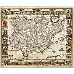
Typus Hispaniae ab Hesselo Gerardo delineata. . .
Decorative map of the kingdom of Spain and Portugal by Joan. Janssonius after the cartographic source by Hessel Gerard. Embellished by sailing ship, compass roses, and co...
- $550 / ≈ €515
Place & Date: Amsterdam, 1638
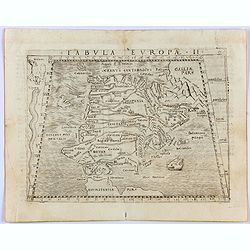
Tabula Europae II. (Spain and Portugal)
Gastaldi's map showing Spain and Portugal, based upon Ptolemy.It is one of the earliest obtainable maps of the region.From Giacomo Gastaldi's Atlas of 1548 which has been...
- $375 / ≈ €351
Place & Date: Venice, 1548
A mapof the Kingdom of Spain and Portugal from the latest & best Observations. . .
An interesting copper engraved map of Spain and Portugal, with an attractive rococo cartouche. Nicholas Tindal (1687-1774) / Paul de Rapin (1661-1725) were responsible fo...
Place & Date: London, 1743
![[Spain and Portugal]](/uploads/cache/47718-250x250.jpg)
[Spain and Portugal]
A rare map of Spain and Portugal engraved by Jan and Lucas van Deutecom and published by Gerard de Jode, Antwerp 1593. Latin text on verso.The map appeared in the second ...
Place & Date: Antwerp, 1593

La pericolante ostinata. Papagallo No. 20 Anno II.
Design by Augusto Grossi. Taken from the Italian satirical newspaper Il Papagallo, a satirical magazine founded in January 1873 by Augusto Grossi (1835-1919), which speci...
Place & Date: Bologne, 1874
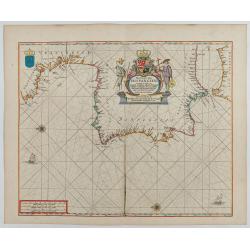
Pas-Caart van Hispangien vertoonde de Custen van Granade…
An eye-catching chart of Spain and Portugal, including a large part of Brittany and the southwestern coast of France, including Isle de Reé , Isle Saint Martin ...Pieter...
Place & Date: Amsterdam, 1669-1676

Paskaerte Vande Bocht van Vranckrijk Biscajen en Galissen
An eye-catching chart of Spain and France, including a large part of Brittany, including Isle de Reé , Isle Saint Martin ...Shows the gulf of the northeast Atlantic Ocea...
Place & Date: Amsterdam, 1669-1676

Nova et accurata Tabula Hispaniae. . .
Second state. The map shows the geographical image introduced by Hessel Gerritsz's 1612 wall map of Spain, based on information provided by the Coimbra University profess...
Place & Date: Amsterdam, 1633