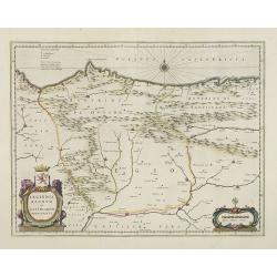
Legionis Regnum et Asturiarum Principatus.
A very decorative map by Willem Blaeu of the Spanish Province Asturias, Castile and Léon, including the towns of Oviedo, Leon, Santander, Valladolid, etc. With two fine ...
Place & Date: Amsterdam, 1645
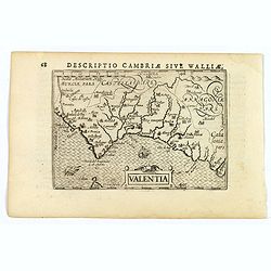
Valentia.
A fine miniature map of the Spanish province of Valencia, published by Petrus Bertius in Amsterdam early in the seventeenth century. The map features a nice strap-work ti...
Place & Date: Amsterdam, 1606
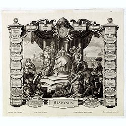
Hispanus.
Allegorical print of Spain (Hispanus), copper engraving after P. Decker by M. Engelbrecht. Taken from "Laconicum Europae Speculum". Philippe Andrea Kilian (1714...
Place & Date: Augsburg, 1737
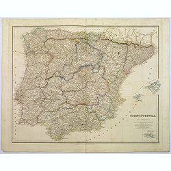
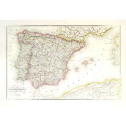
Spain & Portugal.
A large steel engraved map of European neighbours of Spain and Portugal. Including Balearic Islands, with a further inset map of Minorca. Numerous place names and physica...
Place & Date: London, 1839
Carte géographique, physique et politique des royaumes d'Espagne et de Portugal indiquant les chemin fer en exploitations, ceux en cours d'éxécutions
Very large, highly detailed and uncommon map of Spain, Portugal and the northern coast of Africa. The map shows according to the title: rail roads, main interregional rou...
Place & Date: Paris, c.1867
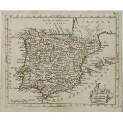
L' Espagne et le Portugal . . .
Map of Spain and Portugal, from Atlas moderne portatif composé de vingt-huit cartes sur toutes les parties du globe terrestre .. A l'usage des Colléges, des Pensions &a...
Place & Date: Paris, Prudhomme, Levrault, Debray, 1806
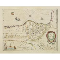
Biscaia et Guipuscoa Cantabriae veteris Pars.
Shows cities of Bilbao and Laredo, and includes a charming vignette of a putti with surveying equipment, being observed by a kitten. With Dutch text on verso.More about m...
Place & Date: Amsterdam, 1645
Arragonia Regnum.
A beautiful, highly decorative map of Aragon, centered on Saragossa and extending to Balbasdtor, Huesca, Calataiud, Tortosa, Tervel, Albarrazin and Cuenca. Towns, rivers,...
Place & Date: Amsterdam, 1645
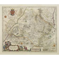
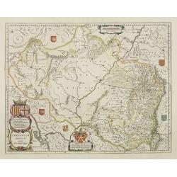
Navarra Regnum.
Decorative map of the region which includes the city of Pamplona at the centre of the map, Bayonne and San Sebastian. Highly decorative figured cartouche bottom left. Fou...
Place & Date: Amsterdam, 1645
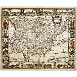
Nova et accurata Tabula Hispaniae. . .
Second state. This "carte à figures"- map of Spain and Portugal shows the geographical image introduced by Hessel Gerritsz's 1612 wall map of Spain. The map is...
Place & Date: Amsterdam, 1633