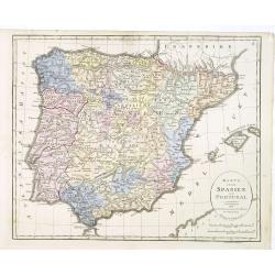
Karta öfver Spanien och Portugal.
An very rare map of Spain and Portugal with Swedish text. This is an updated version of his map of 1819 and is now dated 1833.From his atlas "Geographisk Hand-Atlas&...
- $100 / ≈ €94
Place & Date: A. Wiborgs förlag, Stockholm, ca. 1848
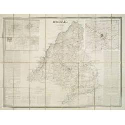
Madrid por el Teniente Coronel, Capítan de Ingenieros D. Francisco Coello. Las notas estadisticas é historicas han sido escritas por D. Pascual Madoz. Madrid 1853.
Second edition of this important and very detailed map of the region of Madrid prepared by Francisco Coello (1822 - 1898) and improved by Pascual Madoz (1806 - 1870). Eng...
- $400 / ≈ €374
Place & Date: Madrid, 1853
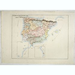
Circoscrizione delle province ecclesiastiche e Diocesinei regni di Spagna e Portogallo (Tav XLVI)
A large-format map of Spain and Portugal with its dioceses. The map is finely engraved and beautifully colored and was prepared by Girolamo Petri, a lawyer who served as ...
- $450 / ≈ €421
Place & Date: Rome, 1858
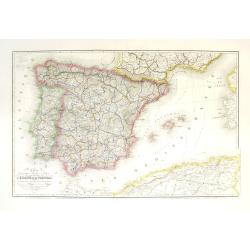
Carte géographique, physique et politique des royaumes d'Espagne et de Portugal indiquant les chemin fer en exploitations, ceux en cours d'éxécutions
Very large, highly detailed and uncommon map of Spain, Portugal and the northern coast of Africa. The map shows according to the title: rail roads, main interregional rou...
Place & Date: Paris, c.1867
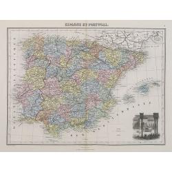
Espagne et Portugal.
A decorative map of Spain and Portugal from Géographie Universelle, Atlas Migeon. With an engraving of the Alhambra in the lower right corner. Published by J. Migeon. Fr...
- $35 / ≈ €33
Place & Date: Paris, 1874

La pericolante ostinata. Papagallo No. 20 Anno II.
Design by Augusto Grossi. Taken from the Italian satirical newspaper Il Papagallo, a satirical magazine founded in January 1873 by Augusto Grossi (1835-1919), which speci...
Place & Date: Bologne, 1874
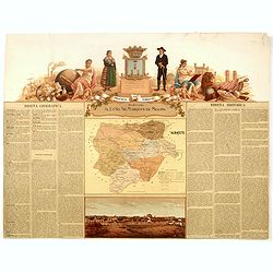
Provincia de Albacete.
Chromolithography published in "Atlas geográfico histórico de las Provincias de España". Map made by M. Vierge, Dedicated to Ilmo. Sr. Dn. Vicente Barrantes....
- $60 / ≈ €56
Place & Date: Madrid, c. 1875
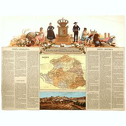
Provincia de Badajoz.
Chromolithography published in "Atlas geográfico histórico de las Provincias de España". Map engraved by M. Vierge, Dedicated to Ilmo. Sr. Dn. Vicente Barran...
- $120 / ≈ €112
Place & Date: Madrid, c. 1875
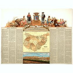
Provincia de Caceres.
Chromolithography published in "Atlas geográfico histórico de las Provincias de España". Map made by M. Vierge, Dedicated to Excmo. Sr. Dn. Cipriano Segundo ...
- $120 / ≈ €112
Place & Date: Madrid, c. 1875
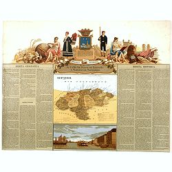
Provincia de Santander.
Chromolithography published in "Atlas geográfico histórico de las Provincias de España". Map engraved by J. Reinoso, Dedicated to Excmo. Sr. Duque de Santona...
- $120 / ≈ €112
Place & Date: Madrid, c. 1875
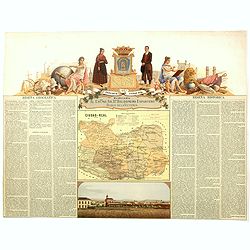
Provincia de Ciudad-Real.
Chromolithography published in "Atlas geográfico histórico de las Provincias de España". Map made by J. Reinoso, Dedicated to Excmo. Sr. Dn. Baldomero Espart...
- $120 / ≈ €112
Place & Date: Madrid, c. 1875
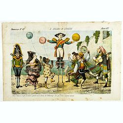
Il bolero in Ispagnia. Papagallo No. 42. Anno VI.
About Spanish expansion, with balloons symbolizing Cuba, Havana, Cortes. Taken from the Italian satirical newspaper Il Papagallo, a satirical magazine founded in January ...
Place & Date: Bologne, 1878
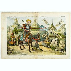
Il Don Cihsciotte a complici. Papagallo No. 48. Anno VI.
Taken from the Italian satirical newspaper Il Papagallo, a satirical magazine founded in January 1873 by Augusto Grossi (1835-1919), which specialized in color-printed ca...
Place & Date: Bologne, 1878