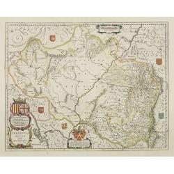
Arragonia Regnum.
A beautiful, highly decorative map of Aragon, centered on Saragossa and extending to Balbasdtor, Huesca, Calataiud, Tortosa, Tervel, Albarrazin and Cuenca. Towns, rivers,...
Place & Date: Amsterdam, 1645
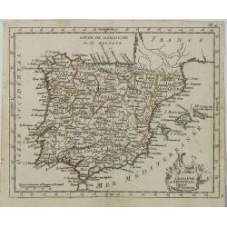
L' Espagne et le Portugal . . .
Map of Spain and Portugal, from Atlas moderne portatif composé de vingt-huit cartes sur toutes les parties du globe terrestre .. A l'usage des Colléges, des Pensions &a...
Place & Date: Paris, Prudhomme, Levrault, Debray, 1806
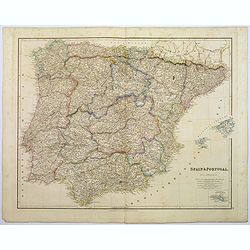
Spain & Portugal.
A large steel engraved map of European neighbours of Spain and Portugal. Including Balearic Islands, with a further inset map of Minorca. Numerous place names and physica...
Place & Date: London, 1839
Carte géographique, physique et politique des royaumes d'Espagne et de Portugal indiquant les chemin fer en exploitations, ceux en cours d'éxécutions
Very large, highly detailed and uncommon map of Spain, Portugal and the northern coast of Africa. The map shows according to the title: rail roads, main interregional rou...
Place & Date: Paris, c.1867
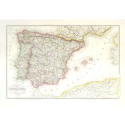
Nova et accurata Tabula Hispaniae. . .
Second state. This "carte à figures"- map of Spain and Portugal shows the geographical image introduced by Hessel Gerritsz's 1612 wall map of Spain. The map is...
Place & Date: Amsterdam, 1633

Cazal. (Casale Monferrato)
A rare panoramic of Casale Monferrato in the Piedmont region. Engraved by Pierre Aveline (Paris, c.1656 - 23 May 1722). He was also a print-publisher and print-seller. H...
Place & Date: Paris, 1690-1730

Tabula Secunda Europe (Spain & Portugal)
Wood block printed large-format Ptolemaic map of the Iberian Peninsula from the 1513 edition of Waldseemüller's Geographia.This Ptolemaic map comes from the first so cal...
Place & Date: Strasburg, 1513

Paskaert vande Bocht van Vranckrijck Biscajen. . .
An eye-catching chart of the coast of Bretagne from Brest running south till the coast of Biscay in Northern Spain.Including the towns of Ferrol in the west, Gijon, Santa...
Place & Date: Amsterdam, after 1666

Madrid.
Extremely rare town-view of Madrid. Engraved by Francesco Ambrosi.With a second title in lower part "Madrid Ciudad Capital Del Reyno D'Espana y real corte de los rey...
Place & Date: Bassano del Grappa, c.1780

La pericolante ostinata. Papagallo No. 20 Anno II.
Design by Augusto Grossi. Taken from the Italian satirical newspaper Il Papagallo, a satirical magazine founded in January 1873 by Augusto Grossi (1835-1919), which speci...
Place & Date: Bologne, 1874

De Haven en Straat von Gibraltar, Niewlyks getekend, en in`t licht gebracht door Johannes Covens en Cornelis Mortier tot Amsterdam.
Decorative map showing the siege of Gibraltar during the Spanish war of succession. This highly interesting map is richly ornated with three additional inset maps and vie...
Place & Date: Amsterdam, 1710
![[Spain and Portugal]](/uploads/cache/47718-250x250.jpg)
[Spain and Portugal]
A rare map of Spain and Portugal engraved by Jan and Lucas van Deutecom and published by Gerard de Jode, Antwerp 1593. Latin text on verso.The map appeared in the second ...
Place & Date: Antwerp, 1593

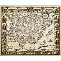
Nova et accurata Tabula Hispaniae. . .
Second state. The map shows the geographical image introduced by Hessel Gerritsz's 1612 wall map of Spain, based on information provided by the Coimbra University profess...
Place & Date: Amsterdam, 1633