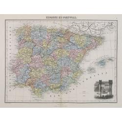
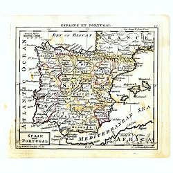
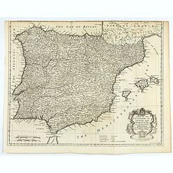
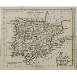
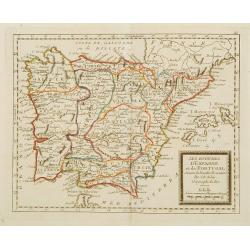
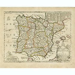
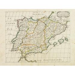
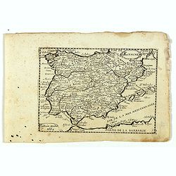
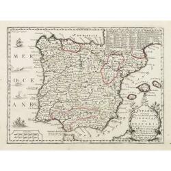
Espagne et Portugal.
A decorative map of Spain and Portugal from Géographie Universelle, Atlas Migeon. With an engraving of the Alhambra in the lower right corner. Published by J. Migeon. Fr...
- $35 / ≈ €33
Place & Date: Paris, 1874
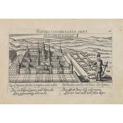
![Hardales in Hispanien. [Spain].](/uploads/cache/13750-250x250.jpg)
Hardales in Hispanien. [Spain].
A very nice view of the city Hardales On the foreground, a man hunting a beaver. With a verse in Latin and German underneath the image.The poet and topographer from Comot...
- $60 / ≈ €56
Place & Date: Frankfurt, 1623-1678
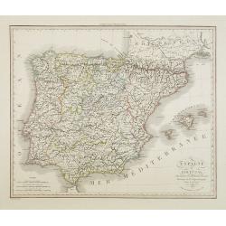
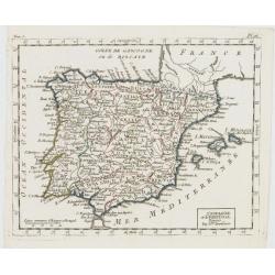
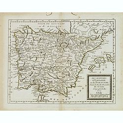
Espagne et Portugal . . .
Detailed map of Spain and Portugal, Majorca and Minorca, etc., prepared by A. H. Basset, rue Saint-Jacques, no. 64, Paris and published in Atlas Classique et Universel de...
- $100 / ≈ €94
Place & Date: Paris, A.H. Basset, 1828
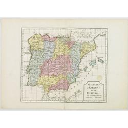
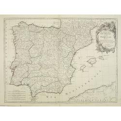
Royaumes d'Espagne et du Portugal.
Map of Spain and Portugal. By C. F. Delamarche, successor of Robert de Vaugondy, Geographer.
- $80 / ≈ €75
Place & Date: Paris, 1794 - 1806
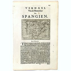
Hispania.
Small map of the Iberian peninsula with the Balearic Islands, surrounded by text in Dutch.Nicolaes de Clerck (de Klerc) was active as an engraver and publisher in Delft f...
- $100 / ≈ €94
Place & Date: Amsterdam, Cloppenburch, 1621
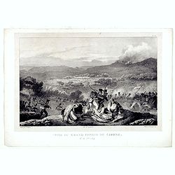
Prise du Grand Convoi de Girone le 26 Fbie 1809.
Fine lithography showing a battle scene during Third Siege of Girona by Godefroy Engelmann" after a drawing by C. Langlois. Godefroy Engelmann was born in 1788 in M�...
- $75 / ≈ €70
Place & Date: Paris, ca. 1820
Spain and Portugal.
Uncommon miniature map of Spain and Portugal, engraved by Thomas Kitching for "A New General and Universal Atlas Containing Forty five Maps by Andrew Dury".This...
- $60 / ≈ €56
Place & Date: London, 1761-1763
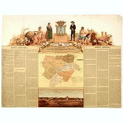
Provincia de Albacete.
Chromolithography published in "Atlas geográfico histórico de las Provincias de España". Map made by M. Vierge, Dedicated to Ilmo. Sr. Dn. Vicente Barrantes....
- $60 / ≈ €56
Place & Date: Madrid, c. 1875
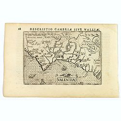
Valentia.
A fine miniature map of the Spanish province of Valencia, published by Petrus Bertius in Amsterdam early in the seventeenth century. The map features a nice strap-work ti...
Place & Date: Amsterdam, 1606
A mapof the Kingdom of Spain and Portugal from the latest & best Observations. . .
An interesting copper engraved map of Spain and Portugal, with an attractive rococo cartouche. Nicholas Tindal (1687-1774) / Paul de Rapin (1661-1725) were responsible fo...
Place & Date: London, 1743
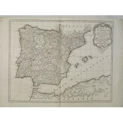
L'Espagne et le Portugal. Divisés Par Gdes. Provinces.
Map of Spain and Portugal, including the Balearic Islands archipelago. From Atlas de la Géographie de toutes les parties du monde .. Ouvrage destiné pour l'education, e...
- $80 / ≈ €75
Place & Date: Paris, Prudhomme, Levrault, Debray, 1806
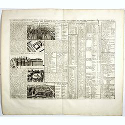
Carte du Gouvernement de la Cour d'Espagne. . .
Engraved text sheet, providing a detailed description of the infrastructure of Spain's ecclesiastical and military government as well as information listed in a lengthy t...
- $75 / ≈ €70
Place & Date: Amsterdam, ca. 1720
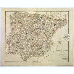
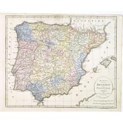
Spain & Portugal.
A large steel engraved map of European neighbours of Spain and Portugal. Including Balearic Islands, with a further inset map of Minorca. Numerous place names and physica...
Place & Date: London, 1839
L' Espagne et le Portugal . . .
Map of Spain and Portugal, from Atlas moderne portatif composé de vingt-huit cartes sur toutes les parties du globe terrestre .. A l'usage des Colléges, des Pensions &a...
Place & Date: Paris, Prudhomme, Levrault, Debray, 1806
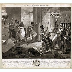
Dédié à l'armée d'Espagne. Prise de Logrono.
Very decorative plate showing the taking of Logrono in 1823, decorative mezzotint by Louis-François Charon (1783-1839) after F.N.Martinet. Published by Jean, Editeur, Ma...
- $75 / ≈ €70
Place & Date: Paris, 1825
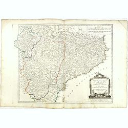
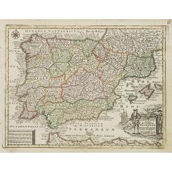
Etats de la Couronne d'Aragon...
Detailed map of the eastern part of Spain. Numerous place-names of counties, cities, towns, physical features.Prepared by "Robert de Vaugondy fils," to whom San...
- $150 / ≈ €140
Place & Date: Venice, 1776 - 1784
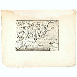
Carte du Gouvernement de Blanes.
Decorative print of the area around Blanes, in Catalonia. Engraved by Pérelle. Embellished with a compass rose.
- $80 / ≈ €75
Place & Date: Paris ca. 1660
Les Royaumes d'Espagne et de Portugal ..
Rare map of Spain and Portugal prepared by J.B.Nolin and published by Monhare for his Atlas Général a l'usage des colleges et maisons d'education.. Louis Joseph Mondhar...
- $120 / ≈ €112
Place & Date: Paris, 1783
S. Laurens in Escurial.
A very nice picture representing the monastery of San Lorenzo del Escorial. On the foreground the god Jano, with two faces. With a verse in two languages underneath the p...
- $90 / ≈ €84
Place & Date: Frankfurt 1623-1678
Karta öfver Spanien och Portugal.
An very rare map of Spain and Portugal with Swedish text. This is an updated version of his map of 1819 and is now dated 1833.From his atlas "Geographisk Hand-Atlas&...
- $100 / ≈ €94
Place & Date: A. Wiborgs förlag, Stockholm, ca. 1848
Carte de l'Espagne Dressée par Guillaume Delisle sur la description de Rodrigo Mendez Sylva . . .. Le tout augmenté et vérifié en 1789. Par Phil. Buache, de l'Académie des Sciences.
Map of Spain published at the outbreak of the French Revolution. Taken from the Atlas Géographique.. published by Dezauche, as successors to De l'Isle & Buache. Publ...
- $150 / ≈ €140
Place & Date: Paris, 1789
L'Espagne nominée Par les Anciens Grecs Iberia ou Hesperia. . .
Lovely small map of Spain with decorative title cartouche, vessels and a sea monster in the Atlantic Ocean.Presenting a panel in the upper right corner listing local rule...
- $150 / ≈ €140
Place & Date: Paris, 1719
Les royaumes d'Espagne et de Portugal. . .
Scarce map of Spain and Portugal prepared by Nolin and published by L.J. Mondhare for his Atlas Général a l'usage des colleges et maisons d'education.. Louis Joseph Mon...
- $100 / ≈ €94
Place & Date: Paris, 1783
Novillinta et accura tilsnia Regnorum Hispaniae et Portugalliae. . .
Miniature map of Spain and Portugal, a reduction of the Seutter''s folio map.From Atlas Minor, here published by Johann Martin Will, with his address in bottom center of ...
- $200 / ≈ €187
Place & Date: Augsburg, J.M.Will, 1778
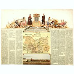
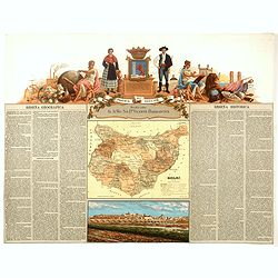
Provincia de Ciudad-Real.
Chromolithography published in "Atlas geográfico histórico de las Provincias de España". Map made by J. Reinoso, Dedicated to Excmo. Sr. Dn. Baldomero Espart...
- $120 / ≈ €112
Place & Date: Madrid, c. 1875
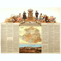
Provincia de Badajoz.
Chromolithography published in "Atlas geográfico histórico de las Provincias de España". Map engraved by M. Vierge, Dedicated to Ilmo. Sr. Dn. Vicente Barran...
- $120 / ≈ €112
Place & Date: Madrid, c. 1875
Provincia de Caceres.
Chromolithography published in "Atlas geográfico histórico de las Provincias de España". Map made by M. Vierge, Dedicated to Excmo. Sr. Dn. Cipriano Segundo ...
- $120 / ≈ €112
Place & Date: Madrid, c. 1875
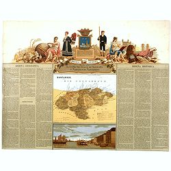
Provincia de Santander.
Chromolithography published in "Atlas geográfico histórico de las Provincias de España". Map engraved by J. Reinoso, Dedicated to Excmo. Sr. Duque de Santona...
- $120 / ≈ €112
Place & Date: Madrid, c. 1875
Espagne. . .
Map of Spain and Portugal prepared by N.Sanson and published by Pierre Mariette.Published in an early edition of the small Sanson atlas L'Europe Dediée a Monseigneur . ....
Place & Date: Paris, P. Mariette, 1667
Espagne.
Rare map of Spain and Portugal, published by Jollain in 1667. Published in "Trésor Des Cartes Geographiques Des Principaux Estats de Lunivers".This atlas is ba...
- $200 / ≈ €187
Place & Date: Paris, 1667
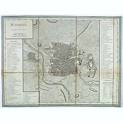
Madrid.
Plan of Madrid, by Tardieu. With numbered key (1-74) of the main buildings and buildings of the city. Table with translations of Spanish words in the right bottom.
- $150 / ≈ €140
Place & Date: Paris?, ca. 1790
Prospect des Escurials von vornen gegen Madrid / L'entrée de l'Escurial, en perspective.
A so-called optical print of the the entrance to the Escurial at the foot of the Sierra Guadarrama in Spain. Bilingual title in German and French. Engraved by Leizel.
- $150 / ≈ €140
Place & Date: Augsburg, 1780
Les Royaumes d'Espagne et de Portugal, divisés Par Grandes Provinces..
Attractive map of the Iberian Peninsula. Ornated with a decorative title cartouche showing the coats of arms of Spain and Portugal.Prepared by Le Sieur Janvier, Jean deni...
- $200 / ≈ €187
Place & Date: Venice, 1776 - 1784
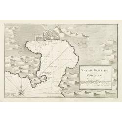
Plan du Port de Cartagene.
Sea chart of the Port of Cartagene. Marked with navigational notes.From the rare chart book by Jacques Ayrouard: Recueil de plusieurs Ports de la Mer Méditerranée...
- $200 / ≈ €187
Place & Date: Marseille, 1732-1746

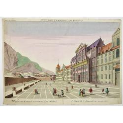
A view of the palace plaisans of Reyn Hongres...
So-called optical print of Aranjuez Palace near Madrid, and wrongly described as situated near to Vienna. Publishedby Huquier, a well-known publisher of optical prints, e...
- $125 / ≈ €117
Place & Date: Paris, 1760
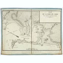
Plan de la baie de Cadiz pour servir aux opérations de 1823.
Detailed map of the bay of Cadiz, drawn up during the battle of the Fort of Trocadero on August 31, 1823, which consecrated the victory of a French expeditionary force ov...
- $175 / ≈ €164
Place & Date: Paris, ca. 1823
Vue perspective de la Grande Place de St.Francois a Seville.
So-called optical print. Daumont was a well-known publisher of optical prints, established in Paris. In the eighteenth and nineteenth centuries there were many popular sp...
Place & Date: Paris, 1760
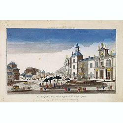
Vue perspective de la prison royale de Madrid en Espagne . . .
So-called optical print of the Royal Prison, now the Ministry of Foreign Affairs in Madrid. Published by Jacques Chereau, who was a well-known publisher of optical prints...
- $200 / ≈ €187
Place & Date: Paris, ca. 1750
L'Espagne nominée Par les Anciens Grecs Iberia ou Hesperia..
Lovely small map of Spain with decorative title cartouche, vessels and a sea monster in the Atlantic Ocean.Presenting a panel in the upper right corner listing local rule...
Place & Date: Paris, 1719
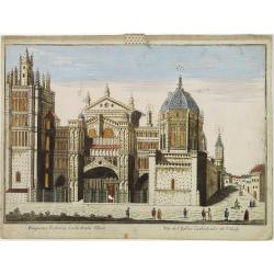
Vüe de L'Eglise Cathedrale de Tolede.
A so-optical print of a church in Toledo, Spain, prepared for use in a light-box or an amusing light-show. This richly hand colored print is much perforated, windows are ...
Place & Date: Italy ca 1780