Browse Listings
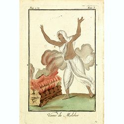
Venue du Malabar.
Originally hand-colored mezzotint of a widow of Malabar engraved by Félix Mixelle and Lachaussée Jeune after Jacques Grasset de Saint-Sauveur.As an etcher, drawer and w...
Place & Date: Paris,1801-1806
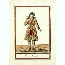
Femme Samoïede.
Originally hand-colored mezzotint of a Samoïede woman engraved by Félix Mixelle and Lachaussée Jeune after Jacques Grasset de Saint-Sauveur.As an etcher, drawer and wr...
Place & Date: Paris,1801-1806
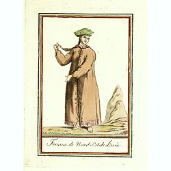
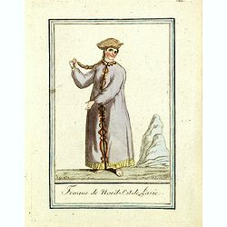
Femme de nord ets de l'Asie.
Originally hand-colored mezzotint of a woman from Nord West Asia engraved by Félix Mixelle and Lachaussée Jeune after Jacques Grasset de Saint-Sauveur.As an etcher, dra...
Place & Date: Paris,1801-1806
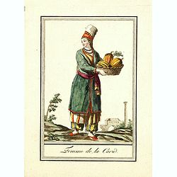
Femme de la Carie.
Originally hand-colored mezzotint costume plate of a woman from the Republic of Karelia, engraved by Félix Mixelle and Lachaussée Jeune after Jacques Grasset de Saint-S...
Place & Date: Paris,1801-1806
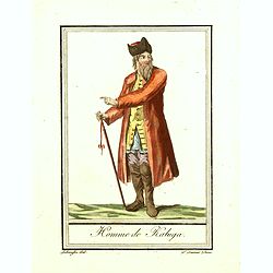
Homme de Kaluga.
Originally hand-colored costume mezzotint of a man from Kaluga engraved by Félix Mixelle and Lachaussée Jeune after Jacques Grasset de Saint-Sauveur.As an etcher, drawe...
Place & Date: Paris,1801-1806
Femme du nord est de l'Asie.
Originally hand-colored mezzotint of a woman from Nord East Russia engraved by Félix Mixelle and Lachaussée Jeune after Jacques Grasset de Saint-Sauveur.As an etcher, d...
Place & Date: Paris,1801-1806

Femme Tattare de Kazan.
Originally hand-colored costume mezzotint of a Kazakhstan women engraved by Félix Mixelle and Lachaussée Jeune after Jacques Grasset de Saint-Sauveur.As an etcher, draw...
Place & Date: Paris,1801-1806
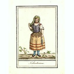
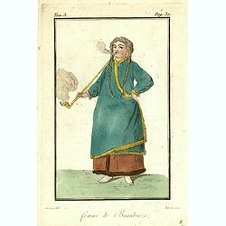
Kabardinienne.
Originally hand-colored costume mezzotint of a Kabardian woman from the Northwest Caucasus, engraved by Félix Mixelle and Lachaussée Jeune after Jacques Grasset de Sain...
Place & Date: Paris,1801-1806
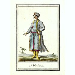
Kabardinien.
Originally hand-colored costume mezzotint of a Kabardian from the Northwest Caucasus, engraved by Félix Mixelle and Lachaussée Jeune after Jacques Grasset de Saint-Sauv...
Place & Date: Paris,1801-1806
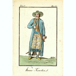
Homme Kouritien.
Originally hand-colored mezzotint of a Siberian man dressed in native garb, engraved by Félix Mixelle and Lachaussée Jeune after Jacques Grasset de Saint-Sauveur.As an ...
Place & Date: Paris,1801-1806
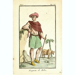
Bagnan de Moka.
Originally hand-colored mezzotint of a Banyan costume in Mocha, Yemen engraved by Félix Mixelle and Lachaussée Jeune after Jacques Grasset de Saint-Sauveur.As an etcher...
Place & Date: Paris,1801-1806
Femme de Barabinze.
Originally hand-colored mezzotint of a woman from Barabinze, engraved by Félix Mixelle and Lachaussée Jeune after Jacques Grasset de Saint-Sauveur.As an etcher, drawer ...
Place & Date: Paris,1801-1806
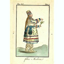
Femme Mordivine.
Originally hand-colored mezzotint of a Mordvinian woman from Ural region dressed in native garb, engraved by Félix Mixelle and Lachaussée Jeune after Jacques Grasset de...
Place & Date: Paris,1801-1806
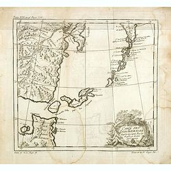
Carte des Isles Kouriles, d'après la carte Russe dréssée et gravée par Laurent.
An interesting map of the Kuril Islands, northeast from Hokkaido, Japan, to Kamchatka, Russia, separating the Sea of Okhotsk from the North Pacific Ocean.Prepared by Jacq...
Place & Date: Paris, 1738-1775
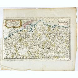
Carte de la sibérie et des Pays voisins.
An interesting detailed map of Siberia, extending from the White Sea and the Caspian Sea in the west to Irkuckoi Province .Prepared by Jacques Nicolas Bellin after Dutch ...
Place & Date: Paris, 1738-1775
![[East coast of Africa, Arabia and west coast of India.]](/uploads/cache/04762-250x250.jpg)
[East coast of Africa, Arabia and west coast of India.]
Rare. Map of the east coast of Africa, Including Madagascar, the Arabian Peninsular, coast of Pakistan and west coast of India.Prepared by Joao Teixeira in 1649, this cha...
Place & Date: Paris, 1664-1696
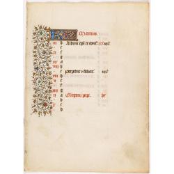
A manuscript leaf from a Book of Hours. (Calendar month of March)
RECTO : Calendar month of March with a 2-line initial in liquid gold on colored ground. colorful panel border in the left margin of acanthus leaves and flowers, with blac...
Place & Date: Paris, ca. 1450

Amerique Septentrionalis..
A handsome map showing California as an island, open-ended Great Lakes and other details based mainly on Sanson. A large decorative cartouche occupies the area of the nor...
Place & Date: Paris, after1694
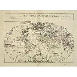
Mappe-Monde Geo-Hydrographique, ou Description Générale. . .
Large map of the world in two hemispheres, in a stereographic projection (each hemisphere 31.5 cm in diameter). California seems to be connected to the mainland, rather t...
Place & Date: Paris, 1719, but ca. 1741-1745
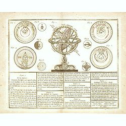
De la Sphère. . .
Scarce print of armillary sphere, surrounded by several diagrams of the sun, moon, and planets after Cassini. In lower part 9 blocks of text with explanations.Published b...
Place & Date: Paris, 1783
![[IX.] Carte du Brabant ou sont les Mairies de Roo, de Nivelle, de Hulpen, et de Geneppe.](/uploads/cache/24689-250x250.jpg)
[IX.] Carte du Brabant ou sont les Mairies de Roo, de Nivelle, de Hulpen, et de Geneppe.
Nice small map straddling the Flemish and the Walloon regions. It shows Halle, Nivelles, La Hulpe, Overijse, Genappe, etc.From Atlas Portatif Universel, by Robert de Vaug...
Place & Date: Paris, later than 1749
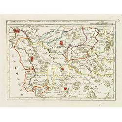
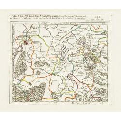
X. Carte du D.ché de Luxembourg.. Jametz &c.
Nice small map encompassing the northwestern part of Lorraine. Showing Mouzon, Stenay, Montmedy..From Atlas Portatif Universel, by Robert de Vaugondy. Edited by : "A...
Place & Date: Paris, later than 1749
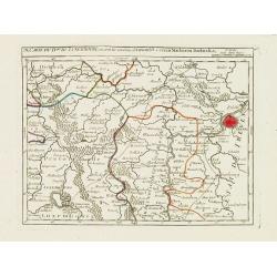
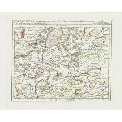
IX. Carte du D.ché du Luxembourg.. Diekirch &c.
Charming small map representing the area between Luxembourg and Trier. From Atlas Portatif Universel, by Robert de Vaugondy.Edited by : "Au dépôt de Géographie, R...
Place & Date: Paris, later than 1749
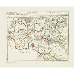
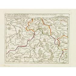
VII. Carte des Frontieres du Luxembourg.. Yvoix &c.
Detailed small map showing an area straddling the border between France and Belgium.From Atlas Portatif Universel, by Robert de Vaugondy. Edited by : "Au dépôt de ...
Place & Date: Paris, later than 1749
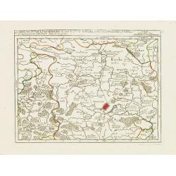
V. Carte du D.hé de Luxembourg.. dans le Lyegeois.
Charming small map representing part of Luxembourg, the southernmost province of Wallonia and of Belgium. Centered on Bastogne.From Atlas Portatif Universel, by Robert de...
Place & Date: Paris, later than 1749
IV. Carte du Duché de Luxembourg où sont les Seign.ries de Lompré..
Charming small map representing part of Luxembourg, the southernmost province of Wallonia and of Belgium.From Atlas Portatif Universel, by Robert de Vaugondy. Edited by :...
Place & Date: Paris, later than 1749
III. Carte du D.hé de Luxembourg.. Cronenburg &c.
Charming small map representing part of the Walloon Region, southeast to Limburg. From Atlas Portatif Universel, by Robert de Vaugondy.Edited by : "Au dépôt de Gé...
Place & Date: Paris, later than 1749
II. Carte du D.é de Luxembourg.. Seign.rie de Lyege &c.
Charming small map representing part of the Walloon Region, south to Liège. From Atlas Portatif Universel, by Robert de Vaugondy.Edited by : "Au dépôt de Géograp...
Place & Date: Paris, later than 1749
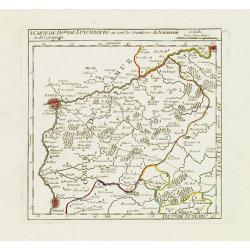
I. Carte du D.ché de Luxembourg ou sont les Frontieres du Namurois et du Lyegeois.
Charming small map representing part of the Walloon Region, delimited by the towns of Namur, Huy, Dinant and Ciney.From Atlas Portatif Universel, by Robert de Vaugondy. E...
Place & Date: Paris, later than 1749
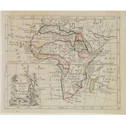
L'Afrique Divisée en ses Principaux Etats.
Map of Africa, from Atlas de la Géographie de toutes les parties du monde.. Ouvrage destiné pour l'education, et nécessaire aux négocians, aux voyageurs, aux fonction...
Place & Date: Paris, Prudhomme, Levrault, Debray, 1806
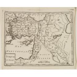
Turquie d'Asie.
Map of Turkey, including Cyprus and part of the Near East. From Atlas de la Géographie de toutes les parties du monde.. Ouvrage destiné pour l'education, et nécessaire...
Place & Date: Paris, Prudhomme, Levrault, Debray, 1806
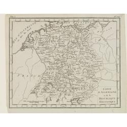
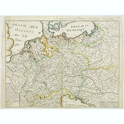
Carte d'Allemagne et de la Republique Helvetique.
Map of central Europe centered on Germany, extending southwards and eastwards to include Poland, the Czech Republic, Austria, Switzerland, Slovenia and part of Italy.From...
Place & Date: Paris, Prudhomme, Levrault, Debray, 1806
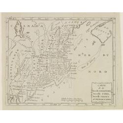
Carte de la Nouvelle Angleterre, Nouvelle York, Nouvelle Jersey, et Pensilvanie.
Map of the north eastern part of the United States, from Atlas de la Géographie de toutes les parties du monde .. Ouvrage destiné pour l'education, et nécessaire aux n...
Place & Date: Paris, Prudhomme, Levrault, Debray, 1806
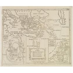
Carte des Régions et des Lieux dont il est parlé dans le Nouveau Testament.
Map of the eastern part of the Mediterranean with its hinterland. In the lower corners two inset maps: a plan of Jerusalem in the lower left, a map of Judea or Palestine ...
Place & Date: Paris, Prudhomme, Levrault, Debray, 1806
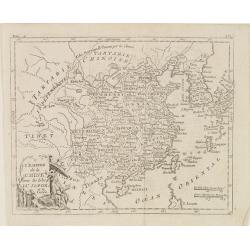
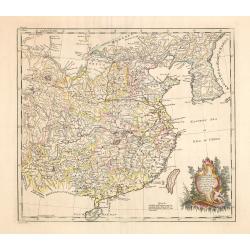
L'Empire de la Chine, avec les Isles du Japon, et la Corée.
Map of south eastern China, including Taiwan, Korea and Japan. From Atlas de la Géographie de toutes les parties du monde .. Ouvrage destiné pour l'education, et néces...
Place & Date: Paris, Prudhomme, Levrault, Debray, 1806
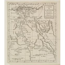
Carte de l'Egypte Ancienne et Moderne..
Map of Egypt illustrating part of the course of the river Nile. From Atlas de la Géographie de toutes les parties du monde .. Ouvrage destiné pour l'education, et néce...
Place & Date: Paris, Prudhomme, Levrault, Debray, 1806
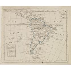
L'Amérique Méridionale, Divisée en ses Principaux Etats.
Map of South America, from Atlas de la Géographie de toutes les parties du monde .. Ouvrage destiné pour l'education, et nécessaire aux négocians, aux voyageurs, aux ...
Place & Date: Paris, Prudhomme, Levrault, Debray, 1806
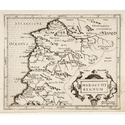
Marocchi Regnum.
From the Mercator/Hondius Atlas Minor. Early map of Morocco.
Place & Date: Amsterdam, 1645
China as surveyed by the Jesuit Misionaries between the years 1708 & 1717 with Korea & the adjoining parts of Tartary.
The map is of interest for the use of Eastern Sea or Sea of China, the sea south of Korea. In the sea along the coast line of Korea : "Kau-Li-Qua or King:m of Korea&...
Place & Date: London, c. 1760
Selling price: $500
Sold in 2014
![Sexta Etas Mundi. Bressla. [Breslau or Wrocław] CCXXXIIII.](/uploads/cache/33138-250x250.jpg)
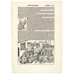
Sexta Etas Mundi. Bressla. [Breslau or Wrocław] CCXXXIIII.
A very fine presentation of the city of Bresslau / Wrocław (230 x 520mm.), in Poland, centered on the cathedral (Dim. : 232 mm W : 520 mm).Overleaf, the kings Wenceslaw ...
Place & Date: Nuremberg, 12 July 1493
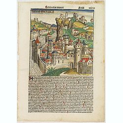
Tercia Etas Mundi. Folium.XLVI (A English town view)
Large woodcut depicting an imaginary English town (235x223mm.) and on verso the genealogy of King David.Page from the richest illustrated Incunable, the famous: Chronicle...
Place & Date: Nuremberg, 12 July 1493
Sexta Etas Mudi. Folio CCLV. (With portret of Johannes Müller alias Regiomontanus holding a Astrolabe.
A very fine presentation of the astronomer Johannes Müller alias Regiomontanus holding a Astrolabe. A village-scene (Dim. H : 150 mm W : 223 mm) is depicted on the lower...
Place & Date: Nuremberg, 12 July 1493
Magnae Britanniae pars meridionalis in qua regnum Angliae. . .
Johann Baptist Homann's well-engraved map has a large decorative cartouche at top right and a large scene at bottom center showing a throned ruler, presumably George I, h...
Place & Date: Nuremberg, 1740
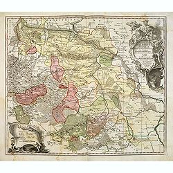
Principatus Halberstadiensis, abbat : Quedlinburgens cum Comitatu Wernigerodano, ad hodiernum verum statum ex acta prodiit ex officina geogr. . .
Detailed map showing principality Halberstadt, Abtei Quedlinburg and the county Wernigerode. Including the towns of Osterwieck, Stollberg, Aschersleben and Oschersleben.
Place & Date: Augsburg, 1750
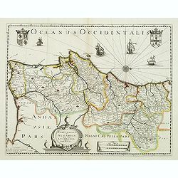
Portugallia et Algarbia quae olim Lusitania. . .
Rare map of Portugal with decorative title cartouche. Oriented to the west. Prepared by Fernando Alvares Seco.
Place & Date: Paris, c.1630
Carte generalle d'allemaigne nouvellement misse en françois et Ampliffiée de tous les Royaumes. . .
Attractive and rare map of Germany, the Low Countries, Austria, Switzerland and part of Poland.
Place & Date: Paris, 1632-1660
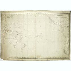
Carte générale de l'océan pacifique. . .
depicting the Pacific Ocean, with nice detail of Hawaii. With a complete outline for Australia and Tasmania. Shows the south east Asian region and South America.Mapping ...
Place & Date: Paris, 1833
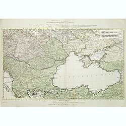
Kriegstheater oder Graenzkarte Oesterreichs, Russlands, und der Türkey. . .
Map of the theatre of war in the Balkans, Ukraine and around the Black Sea, indicating the Austrian, Russian and Turkish spheres of influence. Printed on two sheets and j...
Place & Date: Artaria und Compagnie, Vienna, 1788
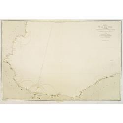
Carte de la Mer Noire. (1e Feuille). Du Bosphore à Mangalia et du Bosphore au Cap Kerempeh.
Very detailed chart of the Turkish part of the Black Sea including the towns of Constantinople (Istanbul) , Bourgas. Showing soundings in meters, lighthouses are marked w...
Place & Date: Paris, 1860, updated for 1870
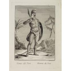
Uomo del Perù. / Homme du Perou.
Full portrait of a Peruvian warrior. From “Raccolta di … stampe.” a series of historically significant eighteenth-century copper plate engravings by Venetian engrav...
Place & Date: Venice, Antonio Zatta, c.1790
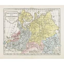
Partie Septentrionale de la Russie Européenne . . .
Detailed map of European part of Russia, including Finland and Lapland.
Place & Date: Paris, 1780
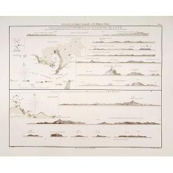
Küstenansichten von Japan bis Capstadt und St. Helena in 5 Blättern.
Prepared by Officer S.M.S. Arcona during the German expedition of 1860-1861 to South East Asia. Lithographed by Lippold and printed by C.Ulrich of Berlin. Sheet 2 from a ...
Place & Date: Berlin, 1863

Carte de l'Ile de Java. . .
An inset plan of Batavia and clearly indicated rice fields, mountains, forests, towns in profile, and even elephants, suggesting the wealth of detail found on this map. M...
Place & Date: Amsterdam, 1720

Carte d'Asie divisée en ses principaux Etats.
Uncommon and decorative "carte à figures" wall map, prepared by Clouet, with superb decoration including a wonderful rococo border with vignettes describing hi...
Place & Date: Paris, Mondhare, 1787
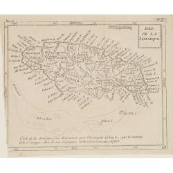
Isle de la Jamaïque.
Map of Jamaica, from Atlas de la Géographie de toutes les parties du monde.. Ouvrage destiné pour l'education, et nécessaire aux négocians, aux voyageurs, aux fonctio...
Place & Date: Paris, Prudhomme, Levrault, Debray, 1806
Selling price: $25
Sold in 2016
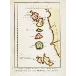
Carte Particuliere des Isles Moluques. . .
A very nice map centered on the island of the Moluccas.Title in French and in Dutch underneath the map.
Place & Date: Amsterdam, 1773
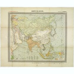
General Karte von Asien. Entworfen und gezeichnet von F. Handtke.
In upper left corner "Carl Flemmings Generalkarten No. / Nr. 37" in a 17th edition. Prepared by Friedrich Handtke (1815-1879). Scale 1: 18.886.000, with a key i...
Place & Date: Glogau, Carl Flemming, c.1910
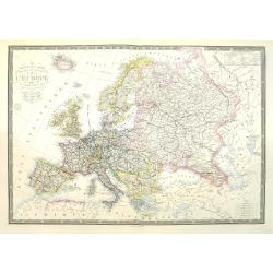
Nouvelle carte physique et politique de l'Europe. Les limites d'états.
Very large, uncommon updated version of the map of Europe prepared by H. Brué and updated by A. Vuillemin. In lower margin "Nouvelle edition" and a date (1875)...
Place & Date: Paris, 1875
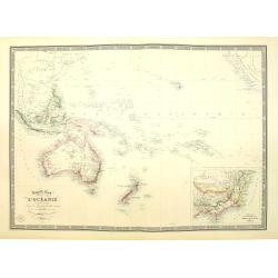
Nouvelle carte de l'Océanie dressée d'après les documents les plus récents par A. Vuillemin, géographe.
Very large, highly detailed and uncommon map of the Pacific with Australia and New Zealand, with inset map of "Partie de l'Australie (Nouvelle Galles du Sud) et Vict...
Place & Date: Paris, 1876
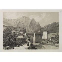
Pont du Crevola au pied de Simplon (Italie).
Uncommon and picturesque lithography of the Crevola Bridge at the foot of the Simplon Mountain in Italy. Published by Carl Johan Billmark and printed by Lemercier in Pari...
Place & Date: Paris, ca.1859
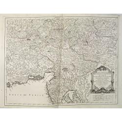
Partie Meridionale du Cercle d'Autriche qui comprend La basse partie du Duché de Strie, Le Duché de Carinthie, divisé en haute et basse, Le Duché de Carniole. . . Et l'Istrie Impériale. . .
Uncommon, finely and crisply engraved map with large decorative title cartouche.Very detailed sheet that is centered roughly on Trieste and extends in to the mouth of the...
Place & Date: Venice, 1784
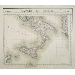
Europe. Naples et Sicile. N.26.
Detailed map including lower half of Italy with the island of Sicily.From his famous Atlas Universel . This atlas was one of the most remarkable world atlases ever produc...
Place & Date: Brussels, 1825-1827
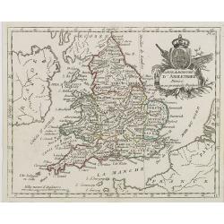
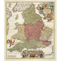
Carte du Royaume d' Angleterre . . .
Map of England and its counties, from Atlas moderne portatif composé de vingt-huit cartes sur toutes les parties du globe terrestre .. A l'usage des Colléges, des Pensi...
Place & Date: Paris, Prudhomme, Levrault, Debray, 1806
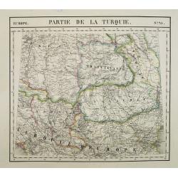
Europe. Partie de la Turquie. N°21.
Detailed map including Hungary and Romania.From his famous Atlas Universel . This atlas was one of the most remarkable world atlases ever produced, anticipating the Inter...
Place & Date: Brussels, 1825-1827
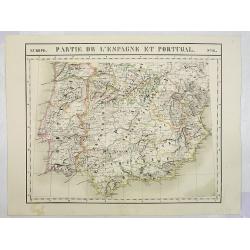
Europe. Partie de l'Espagne et Portugal. N°24.
Detailed map including Southern part of Spain and Portugal.From his famous Atlas Universel . This atlas was one of the most remarkable world atlases ever produced, antici...
Place & Date: Brussels, 1825-1827
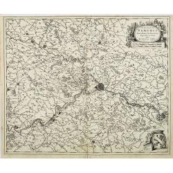
Comitatus Namurci Emendata Delineatio, Nuperrimè in lucem edita, per Nicolaum Visscher.
Detailed engraved map of the province of Namur (Namen), showing cities including Charleroi and Dinant., towns, rivers and lakes. Decorative cartouche with putti. Explanat...
Place & Date: Amsterdam, 1684
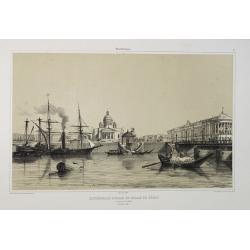
Cathédrale d'Isaac et Palais du Sénat. Vue prise de la Néva. (17 juillet 1839).
A view from the port of the Isaac Cathedral and the Senat Palace in Saint Petersburg on July 17 1839. Plate taken from the first illustrated account of Russian architectu...
Place & Date: Paris, 1845
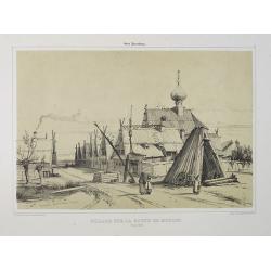
Village sur la route de Moscou. (9 Août 1839).
A view of a village on the way to Saint Petersburg on August 9 1839. Plate taken from the first illustrated account of Russian architecture. This publication was the proj...
Place & Date: Paris, 1842
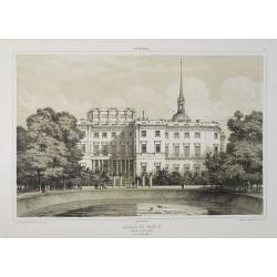
Palais de Paul 1er. Côté du Jardin d'Eté. (16 Juillet 1839).
A view of Paul the First Palace in Saint Petersburg on August 9 1839. Figures are lithographed by Raffet. Plate taken from the first illustrated account of Russian archit...
Place & Date: Paris, 1844
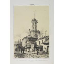
Tour d'Observation et siège de police dans la grande Morskoi. (2 Juillet 1839).
A view of Observation Tower and police headquarters in the Morskoi in Saint Petersburg on August 9 1839. Plate taken from the first illustrated account of Russian archite...
Place & Date: Paris, 1840
Selling price: $250
Sold in 2013
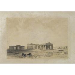
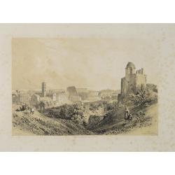
Les Trois Temples de Pestum. Royaume de Naples.
Uncommon and decorative lithography of the Temples of Paestum near Naples. Published by Carl Johan Billmark and printed by Lemercier in Paris, 55 rue de Seine, the leadin...
Place & Date: Paris, c.1859
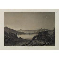
Lac de Nemi (environs de Rome).
Uncommon and picturesque lithography of Lake Nemi, a small circular volcanic lake in the Lazio region, 30 kilometers south of Rome. Published by Carl Johan Billmark and p...
Place & Date: Paris, c.1859
Rome. Vue prise du Mont Palatin.
Uncommon and picturesque lithography of Rome. View from Mount Palatin. Published by Carl Johan Billmark and printed by Lemercier in Paris, 55 rue de Seine, the leading fi...
Place & Date: Paris, c.1859
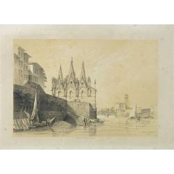
S. Maria della Spina (à Pise).
Uncommon lithography of the Church of S. Maria della Spina in Pisa. Published by Carl Johan Billmark and printed by Lemercier in Paris, 55 rue de Seine, the leading firm ...
Place & Date: Paris, c.1859
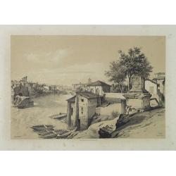
Rome (Ponte Rotto).
Uncommon and picturesque lithography of Rome with a view of the Rotto Bridge. Published by Carl Johan Billmark and printed by Lemercier in Paris, 55 rue de Seine, the lea...
Place & Date: Paris, c.1859
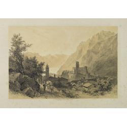
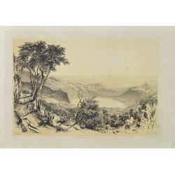
Lac de Garda Vue prise à Teno.
Uncommon and picturesque view of the Garda lake from the town of Teno. Published by Carl Johan Billmark and printed by Lemercier in Paris, 55 rue de Seine, the leading fi...
Place & Date: Paris, c.1859
Lac d'Averne (Roye. De Naples).
Uncommon and picturesque lithography of the Lake Avernus (Lago d'Averno). It was believed to be the entrance to the underworld, and is portrayed as such in the Aeneid of ...
Place & Date: Paris, c.1859
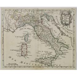
Carte d' Italie . . .
Map of Italy from Atlas moderne portatif composé de vingt-huit cartes sur toutes les parties du globe terrestre .. A l'usage des Colléges, des Pensions & des Maison...
Place & Date: Paris, Prudhomme, Levrault, Debray, 1806
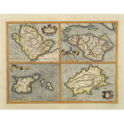
Anglesey. / Iarsay. / Carnesay. / Wight Vectis Olim.
Four maps on one sheet depicting the English islands Jersey, Guernsey, Wright and Alderney.
Place & Date: Amsterdam, 1629
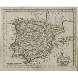
L' Espagne et le Portugal . . .
Map of Spain and Portugal, from Atlas moderne portatif composé de vingt-huit cartes sur toutes les parties du globe terrestre .. A l'usage des Colléges, des Pensions &a...
Place & Date: Paris, Prudhomme, Levrault, Debray, 1806