Browse Listings in Europe > Mediterranean & Islands > Mediterranean

Tafel der Lender darin der Apostel Paulus geprediget hat.
Rare wood block map depicting the Mediterranean, with an over-sized Cyprus from the final Dutch edition of Heinrich Bünting's famous Itinerarium Sacrae Scripturae, a boo...
Place & Date: Magdeburg, 1581

(Sea-chart of Catalunia, Languedoc, Provence, Cote d'Azur, Riviera, Corsica with Marseille, Cannes, Nice, Monaco.)
This very rare chart is important as the first printed sea chart of France's Mediterranean coast, also depicting Catalunya's northern coast, the Italian Cote d'Azur till ...
Place & Date: Amsterdam, 1607

Hydrograhica descriptio
This very rare chart is important as the first printed sea chart of the Mediterranean coast of Spain, Gibraltar, also depicting the northern coast of Marocco.Willem Bar...
Place & Date: Amsterdam, W.Blaeu, 1612

Sardinia / Sicilia.. / Corfu / Zerbi.. / Elba / Malta. . .
Six very fine and early maps on one sheet. Including the islands of Sicily, Corfu, Sardinia, Zerbi (Djerba), Elba and Malta.The map of Malta has a sinking ship at Cala di...
Place & Date: Antwerp, 1570-1612
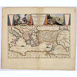
Descriptio Peregrinationis D. Pauli, Apostoli. . .
A striking map of the Mediterranean Sea and its surrounding areas. It depicts the travels of the Apostle St. Paul.The pair of decorative cartouches, presented in a curtai...
Place & Date: Amsterdam, 1650

.Pascaerte Van't Westelyckste der Middelandsche Zee. . .
An eye-catching chart of the western part of the Mediterranean Sea.Pieter Goos (ca. 1616-1675) was one of the most important cartographer, engraver, publisher and print s...
Place & Date: Amsterdam, 1666

Pascaerte Van't Westelyckste der Middelandsche Zee. . .
An eye-catching chart of the western part of the Mediterranean Sea.Pieter Goos (ca. 1616-1675) was one of the most important cartographer, engraver, publisher and print s...
Place & Date: Amsterdam, 1666
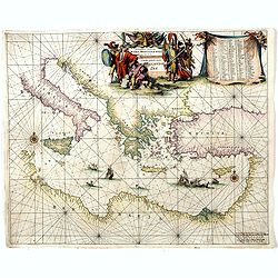
Orientalior districtus Maris Mediterranei.
Beautiful chart of the eastern part of the Mediterranean. Including Italy, the north coast of Africa and part of the Black Sea.The entire sheet is covered with rhumb line...
Place & Date: Amsterdam, 1675
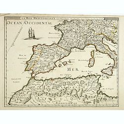
La mer mediterrannée, vers l'Occident. . .
Uncommon map of the western Mediterranean Sea, including France, Spain, Italy, Corsica Sardinia and North Africa. In upper left corner a large sailing vessel.
- $300 / ≈ €281
Place & Date: Paris, 1676
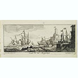
Canistro nel Arcipelago.
Magnificent view of Kanaestreo and its harbour front, decorated with ships and rowing boats in a rough sea. Engraved by Lucas Vostermans II, who was born in 1624, in the ...
- $100 / ≈ €94
Place & Date: Antwerp, c.1690