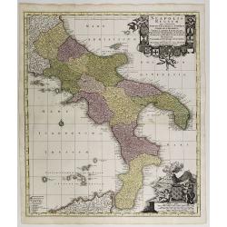
Neapolis Regnum . . .
Map of the region from Naples to Calabria. Cartouche representing Vesuvius erupting.Matthaus Seutter the elder first published his "Atlas Geographicus" in 1720 ...
Place & Date: Ausburg, 1730
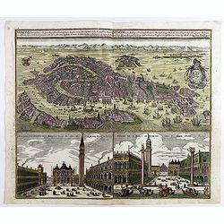
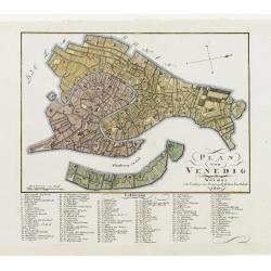
Venetia potentissima e la più magnifica fiorentissimae la più ricca città capitale della Serenissima repubblica . . .
Birds-eye plan view of Venice, depicting the city's architectural landmarks. Below Saint Marco square.Matthaus Seutter the elder first published his "Atlas Geographi...
Place & Date: Augsburg, 1730
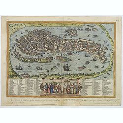
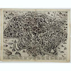
Venetia. (Venice)
Precise, beautiful bird's-eye town-view of Venice, clearly depicting the city's architectural landmark. The surrounding lagoon is animated with a great variety of sailing...
Place & Date: Cologne, 1590
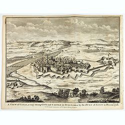
A view of Cassel, a very strong city in Italy, taken by the Duke of Savoy in Decem.r 1706
An interesting copper engraved plan of the Fortification of Cassel in Italy, with an attractive rococo cartouche, showing an overview of the battlefield and surrounding a...
Place & Date: London, 1743
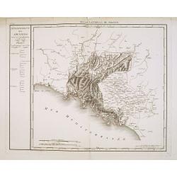
Département des Apennins Divisé en 3 Arrondissemens et en 18 cantons.
Published in the "Atlas National de France" at Chanlaire. Engraved by P.A.F. Tardieu. Represents the department of Apennines which was under French administrati...
Place & Date: Paris, 1790-1811
![Nova & exacta Chorographia Latii sive Territorii Romani iuxta veterem et novum situm parallela nomimu[m] comparatione elaborata.](/uploads/cache/44863-250x250.jpg)
Nova & exacta Chorographia Latii sive Territorii Romani iuxta veterem et novum situm parallela nomimu[m] comparatione elaborata.
Map of central Italy, centered on Rome from "Latium" by A. Kircher and designed by Innocenzo Mattei. The title cartouche in the lower right, small legend with 1...
Place & Date: Amsterdam, 1671
Plan von Venedig.
An uncommon and finely rendered town-plan of Venice. The work is highly detailed and provides a 133 point legend identifying the town's key sites and places of import.
Place & Date: Weimar, 1807

Quita Etas Mundi. Folium.LXVIII (Verona)
The Latin text page is illustrated with an imaginary of Verona, Italy. VERSO are portraits of poets and teachers.Page from the richest illustrated Incunable, the famous:...
Place & Date: Nuremberg, 12 July 1493
Antiquae urbis perfecta et Nova delineatio. [ Ancient Rome)
First state before imprint of Jacobus de Rubeis. A rare view of Ancient Rome from the Lafreri-School in the style of Ambrogio Brambilla's view of about 1575.
Place & Date: Rome, ca. 1600
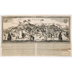
Naples. 1699. Nouvelle et exacte description de la tres-celebre & ancienne Ville de NAPLES
Only recorded broad sheet panoramic view of Naples with underneath in letter press a description of the town's history : "Nouvelle et exacte description de la tres-c...
Place & Date: Paris, 1699