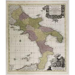
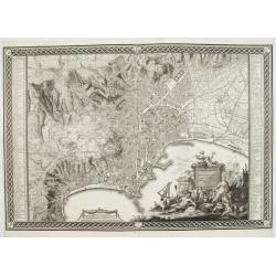
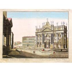
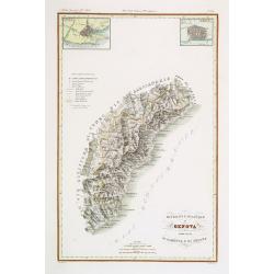
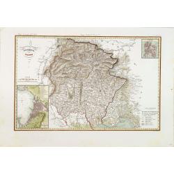
Neapolis Regnum . . .
Map of the region from Naples to Calabria. Cartouche representing Vesuvius erupting.Matthaus Seutter the elder first published his "Atlas Geographicus" in 1720 ...
Place & Date: Ausburg, 1730
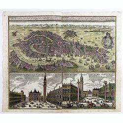
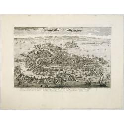
Venetia potentissima e la più magnifica fiorentissimae la più ricca città capitale della Serenissima repubblica . . .
Birds-eye plan view of Venice, depicting the city's architectural landmarks. Below Saint Marco square.Matthaus Seutter the elder first published his "Atlas Geographi...
Place & Date: Augsburg, 1730
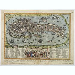
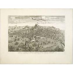
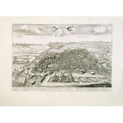
Venetia. (Venice)
Precise, beautiful bird's-eye town-view of Venice, clearly depicting the city's architectural landmark. The surrounding lagoon is animated with a great variety of sailing...
Place & Date: Cologne, 1590
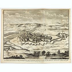
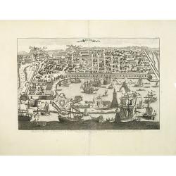
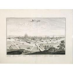
A view of Cassel, a very strong city in Italy, taken by the Duke of Savoy in Decem.r 1706
An interesting copper engraved plan of the Fortification of Cassel in Italy, with an attractive rococo cartouche, showing an overview of the battlefield and surrounding a...
Place & Date: London, 1743
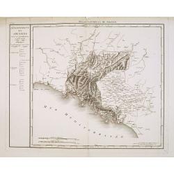
Département des Apennins Divisé en 3 Arrondissemens et en 18 cantons.
Published in the "Atlas National de France" at Chanlaire. Engraved by P.A.F. Tardieu. Represents the department of Apennines which was under French administrati...
Place & Date: Paris, 1790-1811
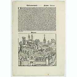
Quita Etas Mundi. Folium.LXVIII (Verona)
The Latin text page is illustrated with an imaginary of Verona, Italy. VERSO are portraits of poets and teachers.Page from the richest illustrated Incunable, the famous:...
Place & Date: Nuremberg, 12 July 1493
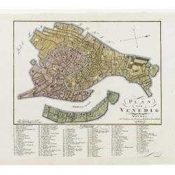
Plan von Venedig.
An uncommon and finely rendered town-plan of Venice. The work is highly detailed and provides a 133 point legend identifying the town's key sites and places of import.
Place & Date: Weimar, 1807
![Nova & exacta Chorographia Latii sive Territorii Romani iuxta veterem et novum situm parallela nomimu[m] comparatione elaborata.](/uploads/cache/44863-250x250.jpg)
Nova & exacta Chorographia Latii sive Territorii Romani iuxta veterem et novum situm parallela nomimu[m] comparatione elaborata.
Map of central Italy, centered on Rome from "Latium" by A. Kircher and designed by Innocenzo Mattei. The title cartouche in the lower right, small legend with 1...
Place & Date: Amsterdam, 1671
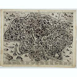
Antiquae urbis perfecta et Nova delineatio. [ Ancient Rome)
First state before imprint of Jacobus de Rubeis. A rare view of Ancient Rome from the Lafreri-School in the style of Ambrogio Brambilla's view of about 1575.
Place & Date: Rome, ca. 1600
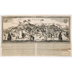
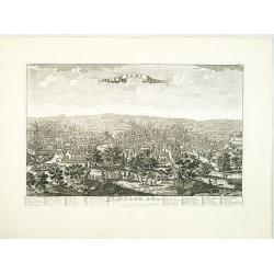
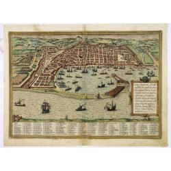
Naples. 1699. Nouvelle et exacte description de la tres-celebre & ancienne Ville de NAPLES
Only recorded broad sheet panoramic view of Naples with underneath in letter press a description of the town's history : "Nouvelle et exacte description de la tres-c...
Place & Date: Paris, 1699
Pianta Della Citta di Firenze nelle seu vere misure colla descrizione dei luoghi piu notabili di ciascun Quartiere.
A highly decorative plan of Florence by Ferdinando Ruggieri. In addition to the detailed plan of the City, it includes fine decorative embellishments and demonstrates the...
Place & Date: Florence, 1755
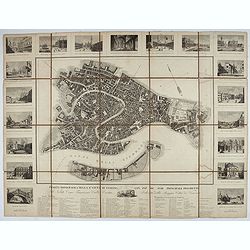
Pianta Topografica della R.a Città di Venezia con XIX de suoi principali prospetti.
A detailed town plan of Venice with an extensive key underneath and nineteen views of the important buildings among which : Piazza di S. Marco, Canal Grande, Tempio della...
Place & Date: Milan: Santo Vallardi, c.1840
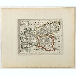
Le Royaume de Sicile.
Uncommon map Sicily and part of Palermo. Very good impression.Like Sanson, Briet was born in Abbeville and became a Jesuit at age 18. His "Parallela Geographiae Vete...
Place & Date: Paris, 1653
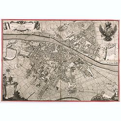
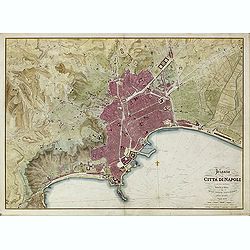
Planta della citta di Napoli come esifte nel prefeute Anno MDCCXC.
Stunning plan of Naples, prepared by Rizzi-Zannoni and engraved by Giuseppe Guerra from Naples. To the right and left a key to the important places of interest, among the...
- $2500 / ≈ €2339
Place & Date: Naples, 1790
Venise / Ville capitale de la République de même nom en Italie.
A very decorative and extremely rare of Venice, including a numbered legend in lower part. Published by Jacques Chéreau, (1688 - 1776). Engraved by Pierre-Alexandre Ave...
- $4000 / ≈ €3743
Place & Date: Paris, ca.1750
Naples, Ville de la Province de Labour, Archiépiscopale, et Capitale du Royaume de Naples.
A very decorative and extremely rare view of Naples, including a numbered (1-18) key in the lower part. Published by Jacques Chéreau, (1688 - 1776). Engraved by Aveline ...
- $3500 / ≈ €3275
Place & Date: Paris, ca.1750
Messine. Anciennement Messena Ville . . .
A very decorative and extremely rare view of Messina on Sicily, including a numbered (1-16) key in lower part. Published by Jacques Chéreau, (1688 - 1776). Engraved by A...
- $3000 / ≈ €2807
Place & Date: Paris, ca.1750
Rome. Profil de la Ville de Rome.
A very decorative and extremely rare town-view of Rome, including a numbered key ( 1-47 ), in lower part. The Vatican with St.Pierre in the left, with great detail. Publi...
- $3300 / ≈ €3088
Place & Date: Paris, ca.1750
Milan. Ville forte, Capitale du Duché de même nom, l'une des plus grandes des des plus considérables de l'Italie.
A very decorative and extremely rare of Milan, including a numbered key ( 1-35 ) in lower part. Published by Jacques Chéreau, (1688 - 1776). Engraved by Aveline and fir...
- $3500 / ≈ €3275
Place & Date: Paris, ca.1750
Turin. Ville Capitale du Piemont et Residence du Duc de Savoye Roy de Sardigne.
A very decorative and extremely rare town-view of Turin, including a numbered key ( 1- 28 ) in lower part. Published by Jacques Chéreau, (1688 - 1776). Engraved by Pierr...
- $2500 / ≈ €2339
Place & Date: Paris, ca.1750

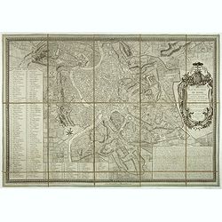
Carte du Gouvernement Civil et Politique de la République de Venise . . .
This impressive engraving provides a detailed description of the infrastructure of the Venetian government.Ornamented with numerous vignettes illustrating sessions of par...
- $100 / ≈ €94
Place & Date: Amsterdam, 1720
Pedemontanae Vicinorumque Regionum.
Fine map including the Italian coast from Monaco till Genoa. Milan in the upper righthand corner and Turin in the center of the map.
- $600 / ≈ €561
Place & Date: Antwerp, 1574-1575
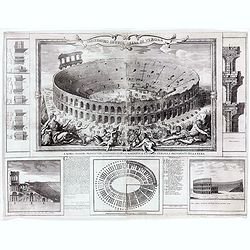
Anfiteatro detto l'Arena di Verona.
Large two sheet copper engraving of the Amphitheater of Verona after a design of Adriano Cristofali. On three sides it is surrounded by architectural details interspersed...
- $2200 / ≈ €2059
Place & Date: Verona, 1744
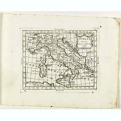
Italia divisa né suoi differenti stati.
Rare map of Italy, Sardinia and Corsica from "Atlante Novissimo ad uso Dei Giovani Studiosi Contenuto In Carte XXVII.", published by Giovanni Zempel in Rome, ca...
- $50 / ≈ €47
Place & Date: Rome, 1780
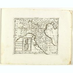
L'Italia Settentrionale presa da quella del Sig. Zannoni.
Rare map of Italy with inset map with Corsica and Sardinia, from "Atlante Novissimo ad uso Dei Giovani Studiosi Contenuto In Carte XXVII.", published by Giovann...
- $75 / ≈ €70
Place & Date: Rome, 1780
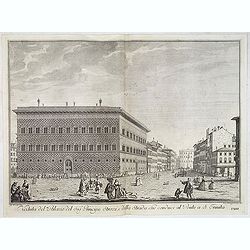
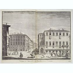
Veduta del Palazzo del Sig.re Principe Strozzi, e della strada che conduce al Ponte a S. Trinita.
Lively street scene with the palace of Mr. Strozzi in Florence after Giuseppe Zocchi (1711or 1717 - 1767) and engraved by Bal. Gabbuggiami from Rome. From "Scelta di...
- $750 / ≈ €702
Place & Date: Florence, Bouchard, 1754
Veduta de' Palazzi de' Sig. March. Corsi e Viviani.
Lively street scene with several palaces in Florence after Giuseppe Zocchi (1711or 1717 - 1767) and engraved by Mich. Mariesschi and Vincenzo Francesschini. From "Sc...
- $450 / ≈ €421
Place & Date: Florence, Bouchard, 1754
Parte Occidentale del Regno Italico, Il Piemonte e Genovestato.
Rare map of Piemonte region in Italy, centered on Piemonte region, Genova and Milan, from "Atlante Novissimo ad uso Dei Giovani Studiosi Contenuto In Carte XXVII.&qu...
- $75 / ≈ €70
Place & Date: Rome, 1780
Patavini territorii../ Tarvisini agri typus.. (2 maps on one sheet)
Two maps on one sheet. Map to the left is a detailed map including Venice and the area north of it, including Padua and Vincenza. Very fine map after Giacomo Gastaldi. Th...
- $300 / ≈ €281
Place & Date: Antwerp, 1598

Veduta della Chiesa e Piazza d'Ognissanti.
Lively view of Piazza Ognissanti in Florence after Giuseppe Zocchi (1711or 1717 - 1767) and engraved by Giuseppe Papini. From "Scelta di XXIV Vedute delle principali...
- $500 / ≈ €468
Place & Date: Florence, Bouchard, 1754
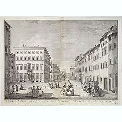
Veduta del Palazzo del Sig.re Marchese Strozzi, del Centauro e della Strada che conduce a S. Maria Novella.
Lively view of a square with the Palace of the Marquis Strozzi of Florence after Giuseppe Zocchi (1711or 1717 - 1767) and engraved by B.Sgrilli. From "Scelta di XXIV...
- $500 / ≈ €468
Place & Date: Florence, Bouchard, 1754
Pianta della Citta di Napoli e de' soui contorni.
Uncommon large scale town-plan of Naples. Drawn and engraved by the "Reale officio topografico".
- $1500 / ≈ €1404
Place & Date: Naples, 1828
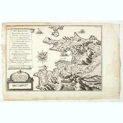
Hic Jacent Puteolorum Bajarum, Miseni Cumarium. . .
A bird's-eye view of Puzzoli and environs, depicting fascinating topographical and architectural features of interest. Title cartouche describes the map and area in Latin...
- $80 / ≈ €75
Place & Date: London, 1725-1744
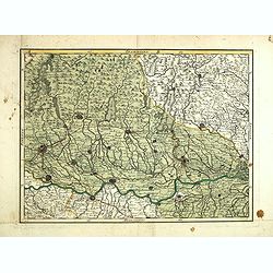
(Untitled map of northern Italy)
Including the towns of Milan, Bergamo, Mantova, Verona with the river Po in the bottom. One page from his multi sheet map "Carta del Territorio della Repubblica Casa...
- $250 / ≈ €234
Place & Date: Florence, 1797
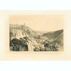
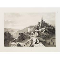
Cascatelles à Tivoli.
Uncommon and decorative lithography of the waterfalls near Tivoli.Published by Carl Johan Billmark and printed by Lemercier in Paris, 55 rue de Seine, the leading firm in...
- $100 / ≈ €94
Place & Date: Paris, c.1859
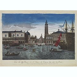
Vue de la Place de St Marc de Venise du côté du port.
Optical print showing the Doge's Palace (Palazzo Ducale), San Marco Square, and Saint Mark's Basilica (Basilica di San Marco in Venice, as seen from the waterside. The im...
- $150 / ≈ €140
Place & Date: Paris, ca. 1750
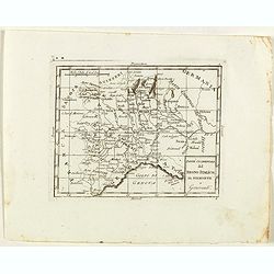
Divisione Militare di Alessandria. Provincie di Casale e di Asti.
"Published in ""Atlante Geografico dell' Italia"". With inset cartouche with detailed plans of the cities of Asti and Casale. Showing the river P...
- $200 / ≈ €187
Place & Date: Florence, 1845

Histoire de la République de Venise.
The History of the Republic of Venice Historia della Republica Veneta (dal 1613 al 1671), in Italian, which goes from 1613 to 1671, was translated by François Tallemant,...
- $1800 / ≈ €1684
Place & Date: Cologne, Pierre Marteau, 1682

Maison de plaisance près de Parme.
So-called optical print of a country house near Parma, by the well-known publisher of optical prints, Basset, established in rue St.Jacques in Paris.In the eighteenth and...
- $150 / ≈ €140
Place & Date: Paris, 1760
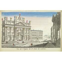
Vue de l'eglise de St Jean de Latran.
So-called optical print of the church Saint Jean de Latran, by Basset a well-known publisher of optical prints, established in rue St.Jacques in Paris. With brief key lis...
- $150 / ≈ €140
Place & Date: Paris, 1760
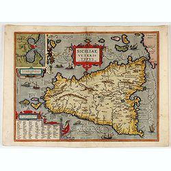
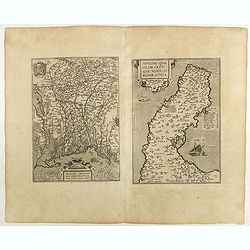
Siciliae Veteris Typus.
A very beautiful early map of ancient Sicily. Title cartouche centered on the upper part: includes also an inset map of Syracuse in the upper left, and a list of the town...
- $600 / ≈ €561
Place & Date: Antwerp, 1587

Vue de l'Entree de la Cour.. de la rue de l'Arno a Florence
So-called optical print of Arno Street in Florence, in Tuscany region.Probst was the best-known publishers of optical prints, established in Augsburg.In the eighteenth an...
- $250 / ≈ €234
Place & Date: Augsburg 1750
Tempum S.Joannis in Laterano Romae. . .
A so-called optical print. In the eighteenth and nineteenth centuries there were many popular specialty establishments in Paris, Augsburg and London which produced optica...
- $150 / ≈ €140
Place & Date: Italy, ca.1780
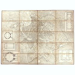
Plan de la ville de Rome, d'après celui publié par J.B. Nolli . . .
Beautiful town-plan of Rome, drawn up after the famous plan of Rome, executed by Giambattista Nolli in 1748. Decorated with a beautiful title cartouche topped by the coat...
- $1000 / ≈ €936
Place & Date: Paris, Jean, 1801
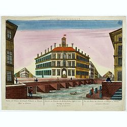
Prospect von Livorn. - Venduta del Palazo del Console D'Olanda in Venezia Nova in Livorne.
So called optical print published by Joseph Carmine showing the home of the Dutch consul in Livorno. Engraved after a design of Antonio Piemontesi. A well-known publisher...
- $100 / ≈ €94
Place & Date: Augsburg, ca. 1790
Plaisance ou Piacensa, ville de la Lombardie, capitale du duché de Plaisance.
Rare and beautiful bird's-eye plan of the town of Plaisance in Lombardy, accompanied by 120 key to the most important points in town. Second state with " XIX" i...
- $400 / ≈ €374
Place & Date: Amsterdam, 1704
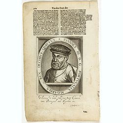
Ionnes III. D. G. Portugaliae Algarbiae etc. Rex. Decimus- Quintus / Fredeicus. II. Exul, Rex Neapolitanus XXI.
The engraving depicts a half length oval portrait of Naples King Fredericus. II and Portuguese King Iohannes III..Nicolaes de Clerck (de Klerc) was active as engraver and...
- $45 / ≈ €42
Place & Date: Amsterdam, Cloppenburch, 1621
Pianta topografica di Roma moderna estratta dalla grande del Nolli an 1829
Town plan of Rome based on map by Giovanni Battista Nolli, ( fl. 1692-1756). Engraved by Pietro Ruga. With a key (I - XIV), scale and text "Nuova pianta di Roma mode...
- $500 / ≈ €468
Place & Date: Rome, 1829
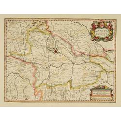
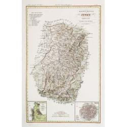
Mantua ducatus.
Important map of northern Italy centered on the dramatic fortress of Mantua.
- $300 / ≈ €281
Place & Date: Amsterdam, 1635

La Rue des Tombeaux à Pompeia.
Uncommon and decorative lithography published by Carl Johan Billmark and printed by Lemercier in Paris, 55 rue de Seine, the leading firm in Europe at that time. From: ...
- $80 / ≈ €75
Place & Date: Paris, c.1859
Sigmundskron (Tyrol, près de Bolzan).
Uncommon and decorative lithography published by Carl Johan Billmark and printed by Lemercier in Paris, 55 rue de Seine, the leading firm in Europe at that time. From: It...
- $60 / ≈ €56
Place & Date: Paris, c.1859
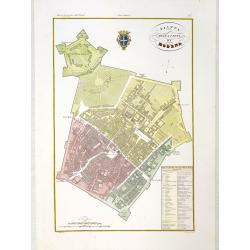
Pianta della citta di Modena.
Very finely engraved and detailed plan of Modena. Coat of arms of the town centred on the upper part. Engraved by V.Angeli and included in: Atlante Geografico dell Italia...
- $150 / ≈ €140
Place & Date: Rome, 1860
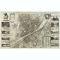
Florentia Pulcherrima et Ruriae Civitas.
Detailed bird's-eye view of the town of Florence in Tuscany region, first published in Frederick de Wit's rare town book. With two keys 1-17 and 1-228 to important spots ...
- $3750 / ≈ €3509
Place & Date: Amsterdam, Leiden, 1697 / 1729
L'alta Lombardia, Terzo Foglio Che comprende parte degli Stati del Re di Sardegna e parte della Repubblica di Genova.
Interesting map covering the border between France and Italy. In Nuovo Atlante Geografico Universale.
- $200 / ≈ €187
Place & Date: Rome, 1791
![[Toscana / Tuscany] En, candidi lectores, elegantioris Italiae partis, Tusciae scilicet, topographiam. aenis nris formis excussam in hac Tabella vobis denuo damus. . .](/uploads/cache/47717-250x250.jpg)
[Toscana / Tuscany] En, candidi lectores, elegantioris Italiae partis, Tusciae scilicet, topographiam. aenis nris formis excussam in hac Tabella vobis denuo damus. . .
A rare map of Tuscany, including the islands of Elba, Giglio, Giannutri and part of Corsica, and covering the whole of Tuscany, part of Liguria, Lombardy, Emilia, Umbria,...
- $6000 / ≈ €5614
Place & Date: Rome, ca 1557
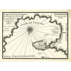
Plan de Porto Ferraro en l'isle de l'Elbe.
An attractive chart centered on the Mediterranean. With scale and large compass-rose. Dated 1727, with the privilege of the King. From : Recueil des Plusieurs plans des p...
- $200 / ≈ €187
Place & Date: Marseille, 1730
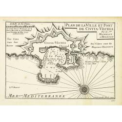
Plan de la Ville et Port de Civita-Vechia.
An attractive chart centered on Civitavecchia, a town and comune of the province of Rome in the central Italian region of Lazio.With scale and large compass-rose. Dated 1...
- $200 / ≈ €187
Place & Date: Marseille, 1730
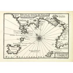
Plan du Golfe de Naples.
An attractive chart centered on the Gulf of Naples. Mount Vesuvius to the right. With scale and large compass-rose. Dated 1727, with the privilege of the King. From : Rec...
- $150 / ≈ €140
Place & Date: Marseille, 1730
Messana, Urbs est Sicilie maxima, situ, opulentia, & tuta navium statione.
Very desirable and early town-plan of Messina on Sicily, with a numbered key (1-167) in lower part. "Messina is shown from the east, in a view looking down upon the ...
- $500 / ≈ €468
Place & Date: Cologne, (1572) 1577
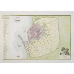
Pianta della citta di Livorno.
Very finely engraved and detailed plan of Livorno. Engraved by V.Angeli and included in: Atlante Geografico dell Italia . To the left, a key to the principal buildings a...
- $150 / ≈ €140
Place & Date: Rome, 1860
Divisione Militare di Genova. Albenga / Savona.
Very finely engraved and detailed map covering the Mediterranean coast from Oneglia, Albenga, Noli until Savona. Upper corners, two inset plans of Savona and Albenga. Key...
- $150 / ≈ €140
Place & Date: Rome, 1860
Governo di Milano / Provincia di Mantova e Cremona.
Very finely engraved and detailed map centered on Mantua, including Cremona. Lower corners two inset plans of Mantua and Cremona. Upper left corner, a key. Engraved by Ve...
- $150 / ≈ €140
Place & Date: Rome, 1860
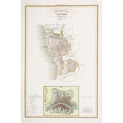
Compartimento Pisano.
Very finely engraved and detailed map centered on Pisa, including Livorno. Centered on the lower part, an inset plan of Pisa. Lower left corner, a key. Engraved by Vetto...
- $200 / ≈ €187
Place & Date: Rome, 1860
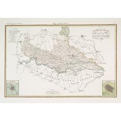
Divisione Militare di Cuneo. Mondovi / Alba.
Very finely engraved and detailed map of Cuneo, centered on the towns of Mondovi and Alba. Lower corners, two inset plans of Mondovi and Alba. Upper right corner, a key. ...
- $200 / ≈ €187
Place & Date: Rome, 1860
Governo di Venezia / Provincia di Udine.
Very finely engraved and detailed map of the area of Udine, with Trieste in lower right corner. Lower left corner an inset plan of Trieste : upper right corner, an inset ...
- $300 / ≈ €281
Place & Date: Rome, 1860
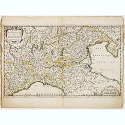
Carte Générale de Lombardie.
Fine map of Northern and middle part of Italy, engraved by A Peyrouin. According to the credit in the cartouche the map has been prepared by Pierre Duval.
- $300 / ≈ €281
Place & Date: Paris, ca. 1650
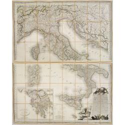
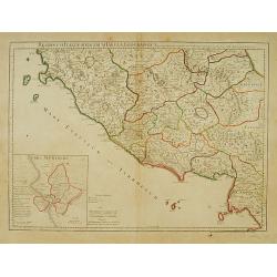
Carte Statistique, Politique, et Mineralogique de l'Italie o'u sont tracées toutes les routes, relais, et distances de postes. . .(2 Maps)
Folding map, extending west to east from Monaco to Otranto and north to south from The Alps to Malta, inset of Greece,. Cartouche depicting Rome and her classical past. P...
- $1000 / ≈ €936
Place & Date: Paris, 1816
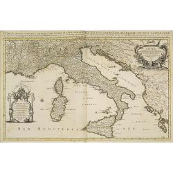
L'Italie distinguee suivant l'estendue de tous les estats. . .
Fine map of Italy with a decorative title and scale cartouche.Alexis-Hubert Jaillot (1632-1712), was a French cartographer. He joined the Sanson heirs and redrew Nicolas ...
- $500 / ≈ €468
Place & Date: Amsterdam, 1692
![[Lake Garda and its surroundings].](/uploads/cache/46166-250x250.jpg)
[Lake Garda and its surroundings].
Alexey Afinogenovich Ilyin was a lieutenant general and cartographer (1832-1889). In 1856, after graduating from the Academy of the General Staff, he was at the military ...
- $100 / ≈ €94
Place & Date: St. Petersburg, 1899
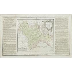
L'Etat de Venise et le Duché de Mantoue..
Attractive map covering the region centered on today region Veneto and its chief town Venice.Extending westwards to include part of Lombardy and eastward to Trieste and I...
- $100 / ≈ €94
Place & Date: Paris, 1790
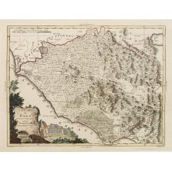
Partie de l' Italie, comprenant les Etats du Roy de Sardaigne. . .
Decorative map of northwest Italy and the Golfo di Genova. With ornamental title cartouche.Flanked by two columns of French text containing geographical information about...
- $100 / ≈ €94
Place & Date: Paris, 1790
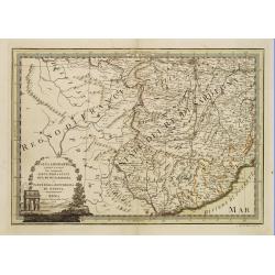
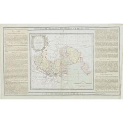
Regionum Italiae mediarum Tabula Geographica. . .
Fine historical map of central Italy with Tuscany, centered on Rome, in the south Pompeii, in the top the island of Giglio and the town Orbetello. Lower left inset plan o...
- $150 / ≈ €140
Place & Date: Paris, 1745
Campagna di Roma Di nuova Projezione. . .
A very striking map of the area south east of Rome, engraved by G.Pitteri embellished with an colored pictorial title cartouche.
Place & Date: Venice, 1798
Selling price: $200
Sold in 2015
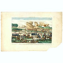
Bataille sur la rive droite de la Brenta. gagnée par les Francais de 22 fructidor an 4. Bonaparte Général en chef. . .
Uncommon print showing the siege of Bassano in 1795, during the French Revolutionary Wars, in the territory of the Republic of Venice, between a French army under Napoleo...
- $150 / ≈ €140
Place & Date: Paris, ca. 1795

Bataille sur la rive droite de la Brenta. gagnée par les Français de 22 fructidor an 4. Bonaparte Général en chef. . .
Uncommon optical print showing the siege of Bassano in 1795, during the French Revolutionary Wars, in the territory of the Republic of Venice, between a French army under...
- $150 / ≈ €140
Place & Date: Paris, ca. 1795

Combat de Palestro.
Showing the battle of Palestro lithographed by E.S. Walter and printed by De Becquet and published by Rousselot in Paris.The lithograph is part of a series of prints publ...
- $100 / ≈ €94
Place & Date: Paris, ca. 1860
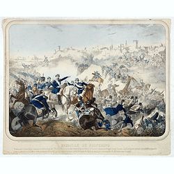
Bataille de Solferino. Pendant que ladivision Forey s'emparait du cimetiére et
Showing the battle of de Solfererino, in Italy. Lithographed by H.Jannin, rue des Bernardins, Paris.Underneath the print a explanation "Pendant que la division Forey...
- $100 / ≈ €94
Place & Date: Paris, ca. 1860
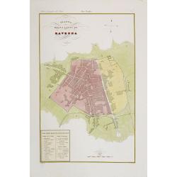
Pianta della citta di Ravenna.
Very finely engraved and detailed plan of Ravenna. Engraved by V.Angeli and included in: Atlante Geografico dell Italia. To the lower left a key to the principal building...
- $200 / ≈ €187
Place & Date: Rome, 1860
Compartimento Pisano.
Very finely engraved and detailed map of the territory of Pisa, including the region of Lucca and Estense. Lower left corner, an inset plan of Pontremoli. Lower right cor...
- $200 / ≈ €187
Place & Date: Rome, 1860
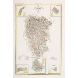
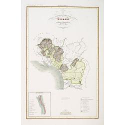
IV Compartimento Aretoni. . .
Very finely engraved and detailed map centered on Arezzo and Lago Trasimeno. Lower part three inset plans of Cortona, Arezzo and Chiusi. In upper corners plans of Montepu...
- $200 / ≈ €187
Place & Date: Rome, 1860