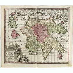
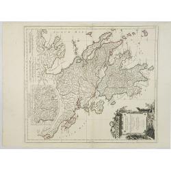
Peloponnesus Hodie Morea Ad Normam Veterum Et Recentiorum Mappa Accuratissime Adornata Aeri Incisa Et Venalis. . .
Decorative regional map of Morea and contiguous islands, with an ornate cartouche showing a lion bearing a sword defeating Turkish and other invaders.
- $450 / ≈ €421
Place & Date: Augsburg, 1740
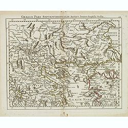
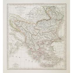
Graeciae pars septentrionalis. . .
Rare map of northern part of Greece and part of Turkey, prepared by Nolin and published by L.J. Mondhare for his Atlas Général a l'usage des colleges et maisons d'educa...
- $80 / ≈ €75
Place & Date: Paris, 1781
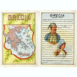
Grecia.
Unique manuscript map of Greece. Award-winning manuscript card, prepared by Antonio Raggio for the 11th Congreso de la Union Postal Universal (World Postal Congress) Expo...
- $250 / ≈ €234
Place & Date: Buenos Aires, 1939
![[Euboe].](/uploads/cache/41989-250x250.jpg)
[Euboe].
Woodcut Ptolemaic-style map by Sebastian Münster figuring Euboea Island, published in the edition of Strabo by Henri Petri in 1571."Strabonis rerum geographicarum&q...
- $100 / ≈ €94
Place & Date: Basle, Henri Petri, 1571
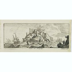
Camos nel Arcipelago. (Samos Island)
Magnificent shipping scene offshore of the island of Samos. Engraved by Lucas Vostermans II, who was born in 1624, in the same year when the family moved to England for s...
- $100 / ≈ €94
Place & Date: Antwerp, c.1690
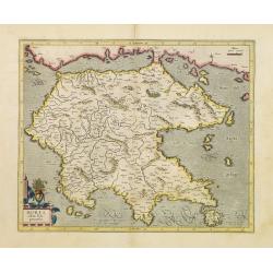
Graeciae Antiquae Specimen Geographicum..
A map of Greece in classical times, with an inset depicting northern Greece. Ornamental title cartouche in the lower left corner.Venetian edition of d'Anville's map, from...
- $250 / ≈ €234
Place & Date: Venice, 1776 - 1784
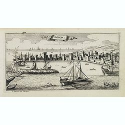
Modon. (Methoni)
Magnificent bird's eye-town-view of Methoni on Morée. Etched by Gaspar Bouttats (1640-1695).The Antwerp based publisher Jacques Peeters published ca. 1690 a series of pr...
- $150 / ≈ €140
Place & Date: Antwerp, c.1690
Turquie d'Europe . . .
Detailed map of Grrece, Marcedonia, Bulgaria, Servia, Roumania, prepared by A. H. Basset, rue Saint-Jacques, no. 64, Paris and published in Atlas classique et Universel d...
- $80 / ≈ €75
Place & Date: Paris, A.H. Basset, 1828
Morea olim Peloponnesus.
Gerard Mercator's map of the Greece's Peloponnesus peninsula called and labeled Morea. A few of the other smaller islands appear included the larger Cerigo (today's Cythe...
- $300 / ≈ €281
Place & Date: Amsterdam, 1630
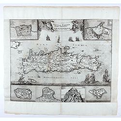
Insula Candia ejusque fortificatio.
An earlier and smaller version of De Wit's map of Candia. Richly engraved work, one of the most beautiful ever produced of Crete. There are insets of the fortifications a...
- $3000 / ≈ €2807
Place & Date: Nuremberg, 1680