
Candia cum Insulis.. Corfu Zante, Milo, Nicsia, Santorini.
Four views on one sheet: A large map of Crete, with three smaller views across the top showing the Ionian Islands of Kerkira (Corfu), Cephalonia and Zakinthos (Zante.) Th...
Place & Date: Amsterdam, 1630
![[56] I.Scio.](/uploads/cache/12828-250x250.jpg)
[56] I.Scio.
"Charming chart of the harbour of the Greek town of Chios. Showing town and harbour plan, with soundings, anchorages, rocks, shoals, fortifications and lighthouses.J...
- $80 / ≈ €75
Place & Date: Marseille, 1764
![[59] Svr I. De Paros.](/uploads/cache/12831-250x250.jpg)
[59] Svr I. De Paros.
Charming chart of the harbour of the Greek island of Paros. Showing town and harbour plan, with soundings, anchorages, rocks, shoals, fortifications and lighthouses.Josep...
- $50 / ≈ €47
Place & Date: Marseille, 1764
![[60] Porto de Ganea.](/uploads/cache/12832-250x250.jpg)
[60] Porto de Ganea.
Charming chart of the harbour of the Greek town of Ganea. Showing town and harbour plan, with soundings, anchorages, rocks, shoals, fortifications and lighthouses.Joseph ...
Place & Date: Marseille, 1764
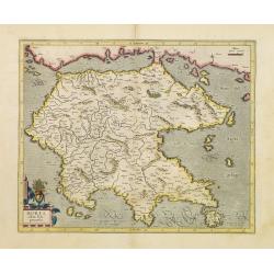
Morea olim Peloponnesus.
Gerard Mercator's map of the Greece's Peloponnesus peninsula called and labeled Morea. A few of the other smaller islands appear included the larger Cerigo (today's Cythe...
- $300 / ≈ €281
Place & Date: Amsterdam, 1630
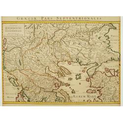
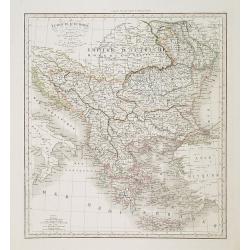
Graeciae Pars Septentrionalis..
Very decorative map illustrating the northern part of Greece and a small part of Turkey. Istanbul is represented on the right margin with its former names Byzantium and C...
Place & Date: Amsterdam, 1720
Graeciae Antiquae Specimen Geographicum..
A map of Greece in classical times, with an inset depicting northern Greece. Ornamental title cartouche in the lower left corner.Venetian edition of d'Anville's map, from...
- $250 / ≈ €234
Place & Date: Venice, 1776 - 1784
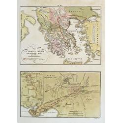
La Grecia Antica . . . / Atene e sue vicinanze . . .
Two rare maps, one of Greece map 175 x 240mm. and the other of Athens 140 x 240mm. with an inset map of Sparta.From l'Atlante Storico, Letterario, Biografico, Archeologic...
Place & Date: Venice, 1840
Turquie d'Europe . . .
Detailed map of Grrece, Marcedonia, Bulgaria, Servia, Roumania, prepared by A. H. Basset, rue Saint-Jacques, no. 64, Paris and published in Atlas classique et Universel d...
- $80 / ≈ €75
Place & Date: Paris, A.H. Basset, 1828
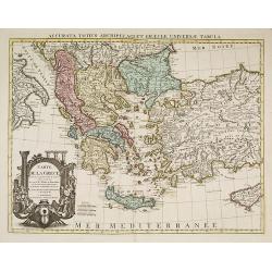
Carte de la Grece dressée sur un grand nombre de memoires. . .
Detailed copper-engraved map of Greece with its neighboring countries, including southern Italy and part of Cyprus. Relief shown pictorially. With large decorative title ...
- $400 / ≈ €374
Place & Date: Amsterdam c. 1745