Browse Listings in Europe > France > France Provinces
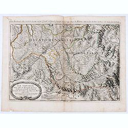
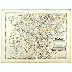
La Savoia divisa nelle sue Principali Provincie da Giacomo Cantelli da Vignola . . .
Late 17th century maps of the Savoy region, based on the reports of Giacomo Cantelli da Vignola and published in Roma in Giacomo de Rossi's world atlas Mercurio Geografic...
- $250 / ≈ €234
Place & Date: Rome, 1692
Disegno Idrografico del Canale Reale . . .
A decorative Coronelli map showing the Canal du Midi. It shows the extent of the canal from the Mediterranean sea at Narbonne to Toulouse. Featuring a pair of large coats...
- $300 / ≈ €281
Place & Date: Venice, 1695-1697
Contado DE Venassino, E prencipato d'Oranges . . .
A most attractive and decorative map centered on Avignon and Orange, by Vincenzo Coronelli. An elaborate title cartouche garlanded with intertwined flowers and dedicated ...
- $400 / ≈ €374
Place & Date: Venise 1690

Plan du Golfe et des Caps de St. Tropez. par Jacques Ayrouard . . .
Large plan of the harbour St. Tropez. Decorated with a large compass rose.From the rare chart book by Jacques Ayrouard: "Recueil de plusieurs plans des ports et rade...
- $300 / ≈ €281
Place & Date: Marseille, 1732-1746

Carte particuliere des costes de Poittou, Aunis et de la Rochelle.
Finely designed and rare map of Isle Ré and the French coast with La Rochelle.
- $1250 / ≈ €1170
Place & Date: Amsterdam, c. 1750

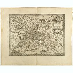
Regionis Biturigum... Per Ioannem Calamaeum. / Limaniae Topographia Gabriele Symeoneo Auct.
Two maps on one sheet. Biturigum. The Loire river is at the right in central France. Neuers (Nevers) is at the middle of the right margin. Bourges is near the center, an...
- $125 / ≈ €117
Place & Date: Antwerp, ca. 1598
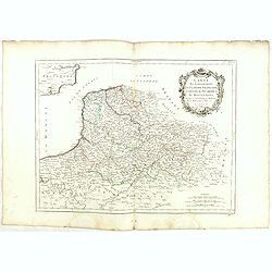
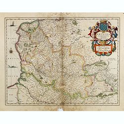
Flandria Gallica Continens Castellanias Insulense . . .
No text on verso. Map of northern part of France, centered on Lille and part of Belgium.
Place & Date: Amsterdam, c. 1660
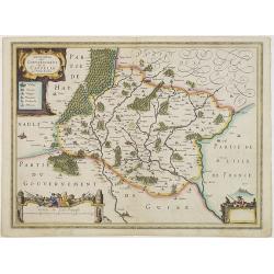
Anjou. Andegavensium Ditionis Vera et Integra Descriptio. Licimo Guijeto Andegavense auctore.
Beautiful map of the Anjou region of western France along the Loire River. Include the city of Angers in the center. Accompanying French text on verso. Dare to go in B...
Place & Date: Antwerp, 1598
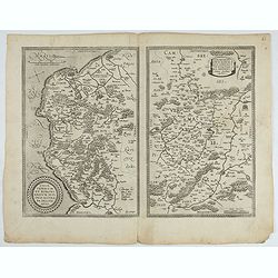
![Blaisois Blesiensis Territorii. . . [together with] - Lemovicum totius et confinium provinciarum. . .](/uploads/cache/40963-250x250.jpg)
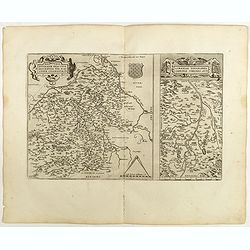
Blaisois Blesiensis Territorii. . . [together with] - Lemovicum totius et confinium provinciarum. . .
The map on the left is centered on the Loire with the town of Blois. The right-hand map is centered on Limoges. Dare to go in Black. All early maps were printed in bla...
Place & Date: Antwerp, 1598
Regionis Biturigum... Per Ioannem Calamaeum. / Limaniae Topographia Gabriele Symeoneo Auct.
Two maps on one sheet. Biturigum. The Loire river is on the right in central France. Neuers (Nevers) is at the middle of the right margin. Bourges is near the center, and...
Place & Date: Antwerp, 1598
![Dépt. du Morbihan. N°. 55. [ Morbihan, Belle-Ile ]](/uploads/cache/43041-250x250.jpg)
Dépt. du Morbihan. N°. 55. [ Morbihan, Belle-Ile ]
Map of the Morbihan region in Brittany. Including "Belle-Ile".Lovely map from one of the last decorative atlases of the nineteenth century.The rather simple map...
Place & Date: Paris, A. Combette, 1852
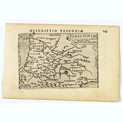
Gasconia.
A lovely miniature map of Gascony, in the S.W. region of France, published by Petrus Bertius, in Amsterdam at the beginning of the seventeenth century. There is a small s...
Place & Date: Amsterdam, 1606
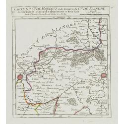
III. Carte du C.té de Haynaut et des Frontieres du C.té de Flandre..
Attractive small map encompassing part of the Nord, between Douai and Valenciennes.From Atlas Portatif Universel, by Robert de Vaugondy.Unrecorded state with erased date....
- $50 / ≈ €47
Place & Date: Paris, after 1748
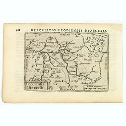
Descriptio Leodiensis Dioecesis.
A decorative map of the ancient Diocese of liege in Belgium, highlighting cities such as Huy, Liege, Tongeren (old capital), Namur and Maastricht. North is orientated to ...
- $100 / ≈ €94
Place & Date: Amsterdam, 1606
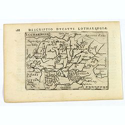
Lotharingia.
Lothringaria (Lorraine) is a historical province of N.E. France, it features the cities of Sarrebourg, Metz, Toul and Nancy. With excellent physical and topographical det...
- $100 / ≈ €94
Place & Date: Amsterdam, 1606
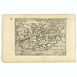
Caletensium et Bononiesium def.
An decorative miniature map of the N.W. France, including Calais and Boulogne. A map full of detail and attractive embelishments. North is orientated to the left. From th...
- $100 / ≈ €94
Place & Date: Amsterdam, 1606
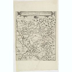
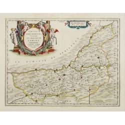
Comitatus Venayscinensis Nova Discriptio.
Rare map depicting part of Provence with Avignon, Cavaillon, Orange, Carpentras, etc.Gerard De Jode was the great rival of Ortelius, both made a living out of selling map...
- $400 / ≈ €374
Place & Date: Antwerp, 1593
Gouvernements de Flandre Françoise, d'Artois, de Picardie. . .
Detailed map encompassing northwestern part of France, with the Channel and tip of southern England. With ornamental title cartouche and noteworthy topographical detail.T...
- $100 / ≈ €94
Place & Date: Venice, 1776 - 1784
Gouvernement de l'Isle de France et de celui de l'Orléanois. . .
Detailed map encompassing present day north of France.Venetian edition of the map by Bellin, to whom Santini gives credit in the cartouche.From "Atlas Universel"...
- $100 / ≈ €94
Place & Date: Venice, 1776 - 1784
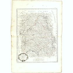
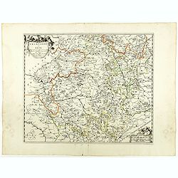
Gouvernements de Champagne et Brie.
Detailed map encompassing Champagne and Brie.Venetian edition of the map by Bonne, to whom Santini gives credit in the cartouche.From "Atlas Universel" publishe...
- $75 / ≈ €70
Place & Date: Venice, 1776 - 1784
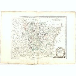
Gouvernements de Lorraine et d'Alsace.
Detailed map encompassing present day the east of France.Venetian edition of the map by Bonne, to whom Santini gives credit in the cartouche.From "Atlas Universel&qu...
- $100 / ≈ €94
Place & Date: Venice, 1776 - 1784
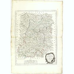
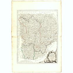
Gouvernements de Berri, du Nivernois,de la Marche, Limousin..
Detailed map encompassing Berri, Nivernois, Limousin and Auvergne.Venetian edition of the map by Bonne, to whom Santini gives credit in the cartouche.From "Atlas Uni...
- $75 / ≈ €70
Place & Date: Venice, 1776 - 1784
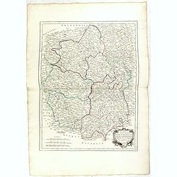
Gouvernements de Bourgogne, de Franche Comté et de Lyonnois.
Detailed map encompassing Bourgogne, Franche Comté and Lyonnois.Venetian edition of the map by Bonne, to whom Santini gives credit in the cartouche.From "Atlas Univ...
- $100 / ≈ €94
Place & Date: Venice, 1776 - 1784
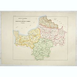
Province ecclesiastiche di Parigi, Rouen, Rheims, E Cambray in Francia (Tav LIV)
This large-format Paris, Rouen, Reims and Cambray map is finely engraved and beautifully colored and was prepared by Girolamo Petri, a lawyer who served as a senior offic...
- $400 / ≈ €374
Place & Date: Rome, 1858
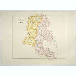
Province ecclesiastiche di Lione e Sens in Francia (Tav LV)
This large-format Lion and Sens map is finely engraved and beautifully colored and was prepared by Girolamo Petri, a lawyer who served as a senior official within the Vat...
- $400 / ≈ €374
Place & Date: Rome, 1858
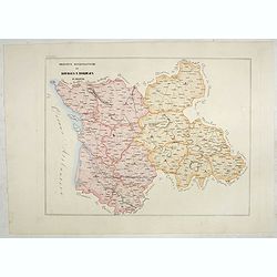
Province ecclesiastiche di Bourges e Bordeaux in Francia (Tav LVIII)
This large-format Bourges and Bordeaux map is finely engraved and beautifully colored and was prepared by Girolamo Petri, a lawyer who served as a senior official within ...
- $300 / ≈ €281
Place & Date: Rome, 1858
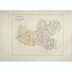
Province ecclesiastiche di Albi, Auche e Toulouse in Francia (Tav LIX)
This large-format Albi, Auch and Toulouse map is finely engraved and beautifully colored and was prepared by Girolamo Petri, a lawyer who served as a senior official with...
- $300 / ≈ €281
Place & Date: Rome, 1858
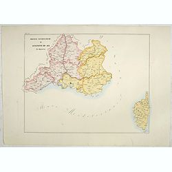
Province ecclesiastiche di Avignone ed Aix in Francia (Tav LX)
This large-format Avignon and Aix map is finely engraved and beautifully colored and was prepared by Girolamo Petri, a lawyer who served as a senior official within the V...
- $300 / ≈ €281
Place & Date: Rome, 1858
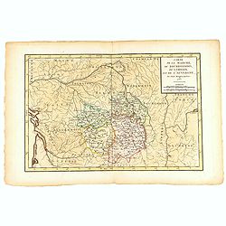
Carte de la Marche, du Bourbonnois, de Limousin, et de l'Auvergne.
Very fine map of Auvergne, Limousin, Bourbonnois and Marche regions in France. Engraved by Ballet and included in the rare atlas "Atlas Universelle" by Philippe...
- $150 / ≈ €140
Place & Date: Paris, 1787
Dioecesis Sarlatensis, vernacule... Sarlat.
Impressive title cartouche with four putti. Detailed map of the region south of the Dordogne River from Bergerac till Saint-Cirq. Including Le Buisson.
Place & Date: Amsterdam 1650
Selling price: $180
Sold in 2009
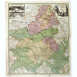
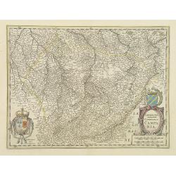
Tabula Geographica Campaniae. . .
Map of the Champagne region with Rheims, Châlons, Vitry in the center. In upper left corner two inset views with the towns of Reims et Troyes.
- $225 / ≈ €211
Place & Date: Nuremberg, ca. 1750
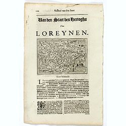
Lotaringia Ducatus.
Small map of Lorraine, oriented with West on top and surrounded by text in Dutch. Nicolaes de Clerck (de Klerc) was active as an engraver and publisher in Delft from 1599...
- $75 / ≈ €70
Place & Date: Amsterdam, Cloppenburch, 1621
Burgundiae inferioris quae Ducatus Nomine Censetur, Des.
Map centered on the province of Burgundy, from 'Theatrum Orbis Terrarum'.Dare to go in Black. All early maps were printed in black and white; many were kept that way for ...
- $100 / ≈ €94
Place & Date: Antwerp, 1598
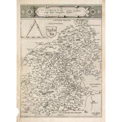
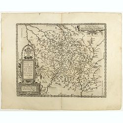
Bitvrigvm, provinciae que Berry.
A rare and beautifully engraved map from the second edition of De Jode's atlas "Speculum Orbis Terrarum". Includes the Loire Valley, centered on Bourges and Vie...
- $200 / ≈ €187
Place & Date: Antwerp, 1593
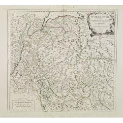
Duché de Savoye qui comprend..
Finely and crisply engraved map of Savoy. Venetian edition of de Vaugondy's map, from "Atlas Universel" printed in 1776-84.Large decorative title cartouche in t...
- $150 / ≈ €140
Place & Date: Venice, 1776 - 1784
![Blaisois Blesiensis Territorii. . . [together with] - Lemovicum totius et confinium provinciarum. . .](/uploads/cache/28865-250x250.jpg)
Blaisois Blesiensis Territorii. . . [together with] - Lemovicum totius et confinium provinciarum. . .
The map on the left is centered on the Loire with the town of Blois. The right hand map is centered on Limoges.
- $150 / ≈ €140
Place & Date: Antwerp, c. 1595
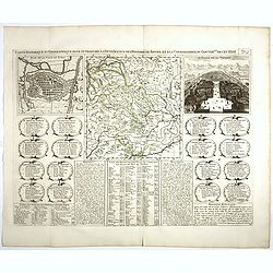
Carte Historique et Geographique pour Introduire a l' Intelligence de l'Histoire de Savoye . . .
Folio sheet with an attractive map of the border region of France, Switzerland and Italy. An inset map of the fortification of Torino and the Palace of Venerie. Cartouche...
- $30 / ≈ €28
Place & Date: Amsterdam, 1728
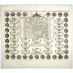
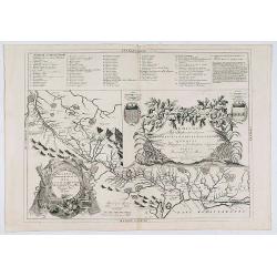
Carte Pour L'Intelligence De L'Histoire De Lorraine . . .
Map of Lorraine, surrounded by 34 portraits of the rulers of Lorraine and information concerning the present government structure of the Duchy. Surmounted by an elaborate...
- $50 / ≈ €47
Place & Date: Amsterdam, 1728
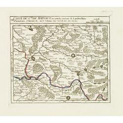
VIII. Carte du C.té de Haynaut où sont les environs de Landrechies..
Attractive small map showing an area straddling the regions Picardy and Nord. It shows the towns of La Capelle, Landrecies and Avesnes-sur-Helpe.From Atlas Portatif Unive...
- $30 / ≈ €28
Place & Date: Paris, 1799
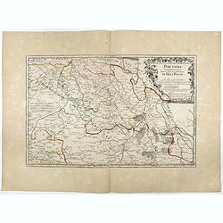
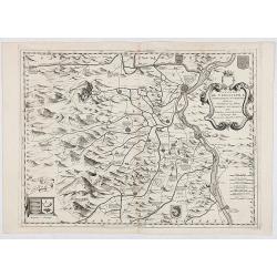
Partie Septentrionale de l'Evesché de Poictiers. Partie Septentrionale du Haut Poitou.
Rare map engraved by R. Michault and published "a Paris chez Greg. Mariette sur le quay de l'Horloge au dessus de la cour de Lamoignon". Dedicated to the Bishop...
- $125 / ≈ €117
Place & Date: Paris, 1690
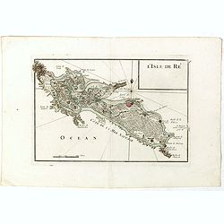
L'Isle de Ré.
Fine map of the French island called Île de Ré. George Louis Le Rouge was active from 1740- till 1780 as a publisher, and was appointed engineer for the King of France....
- $175 / ≈ €164
Place & Date: Paris, 1756
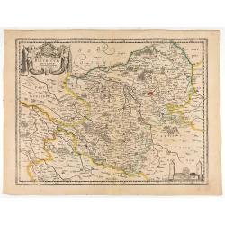
Bituricum Ducatus. Duche de Berri.
A very decorative map with beautiful cartouches of a province of France by one of the most famous map publishers. Berry is a region located in the center of France. It wa...
- $120 / ≈ €112
Place & Date: Amsterdam, 1640
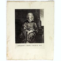
Theodorus Primus Corsicae Rex.
Portrait of Everard Jabach, three-quarter length, standing by the fragment of a column, facing left, wearing a cloak and doublet with plain collar, his left arm held behi...
- $40 / ≈ €37
Place & Date: Paris, 1652 - 1800
Champagne Comitatus Campania.
Map of French region of Champagne, including part of Lorraine. North to the east. The second state with the signature of J.Janssonius.
- $150 / ≈ €140
Place & Date: Amsterdam, 1630
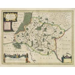
Description du Gouvernement de la CAPPELLE. Par P. Petit Bourbon.
RARE without text on verso. Decorative map of Cappellein the region of the Nord-Pas-de-Calais in France with three decorative cartouches.The map of Cappelle is by Pierre ...
- $150 / ≈ €140
Place & Date: Amsterdam, 1631
Dicecese de Rheims, et le païs de Rethel. . .
Centered on Rheims. A very decorative map with beautiful cartouches of a province of France by one of the most famous map publishers.
- $300 / ≈ €281
Place & Date: Amsterdam, 1658
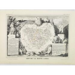
Dépt. De La Haute Loire. N°42.
Map of the Upper Loire region in France.Lovely map from one of the last decorative atlases of the nineteenth century.The rather simple map is framed by medallion portrait...
- $50 / ≈ €47
Place & Date: Paris, A. Combette, 1852
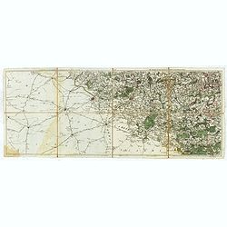
Carte particuliere semi-topographique de l'election de Paris. . .
Very decorative maps. Maps of the Parisian region. Map including Luzarches, Orgeval, Arpajon, Bussy saint georges.
- $300 / ≈ €281
Place & Date: Paris 1779
Dioecesis Sarlatensis, Vernacule.. Sarlat.
Detailed map of the region south of the Dordogne River, depicting Bergerac, Saint Cyprien, Montignac, Sarlat, Villefranche, etc.Embellished with an impressive title carto...
- $200 / ≈ €187
Place & Date: Amsterdam, 1658
Les environs de Mons, Beaumont, Chimay, Valenciennes, Condé, &c.
Detailed map of Northern France, centered on Valenciennes and Mons. The map was prepared by Jean Baptiste de Bouge (1757-1833), who prepared one of the first very detaile...
- $50 / ≈ €47
Place & Date: Bruxelles 1789 - 1793

Plan de St. Jean de Luz avec les différents projets d'agrandissem.t du port.
Very rare and beautiful plan of the city and bay of Saint-Jean-de-Luz, detailing the projects of expansion of the port undertaken in 1780.The plan indicates the Artha Roc...
- $2000 / ≈ €1871
Place & Date: Paris, 1784
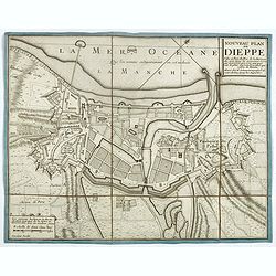
Nouveau plan de Dieppe, ville et port de mer de la Normandie.
Beautiful plan showing the fortified town of Dieppe and the suburbs of Barre and Pollet, engraved by Inselin. Beautiful example.
- $230 / ≈ €215
Place & Date: Paris, ca. 1730
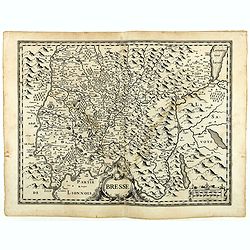
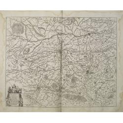
Bresse.
Early map of Eastern France with Lyon to the lower left corner and part of Switzerland. Geneva in upper right corner. Engraved by Hondius. From a French composite atlas.R...
- $150 / ≈ €140
Place & Date: Amsterdam, 1631
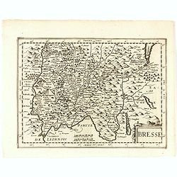
Bresse.
Early map of Eastern France and part of Switzerland. Geneva in upper right corner. With Latin text on verso. Engraved by Petrus Kaerius. Shortly after the publication of ...
- $50 / ≈ €47
Place & Date: Amsterdam, 1632
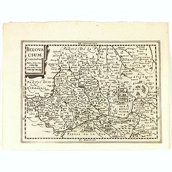
Belovacium comitatus.
Early map centered north of Paris. With Latin text on verso. Engraved by Petrus Kaerius. Shortly after the publication of big folio-atlases the need was apparently felt f...
- $75 / ≈ €70
Place & Date: Amsterdam, 1632
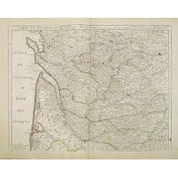
Carte du Bourdelois du Perigord et des provinces voisines..
Map covering the area from La Rochelle till the surrounding country of Bordeaux to the south and till Limoges and Cahors to the east.
- $120 / ≈ €112
Place & Date: Paris, c. 1780
Description du Gouvernement de la CAPPELLE. Par P. Petit Bourbon.
Decorative map of Cappellein the region of the Nord-Pas-de-Calais in France with three decorative cartouches.The map of Cappelle is by Pierre Petit Bourbon (1598-1667), m...
- $100 / ≈ €94
Place & Date: Amsterdam, 1631
Artesia Comitatus. Artois.
Very decorative map of north-western part of France.As Willem Blaeu died in 1638 most of his maps are actually published by his son Joan. This maps carries his (engraved)...
- $80 / ≈ €75
Place & Date: Amsterdam, 1638
(Clermont, Brioude, Le Puy, etc.)
Rare miniature map including the towns of Clermont, Brioude, Le Puy, etc. From "Le theatre De Bellone, Contenant 48. nouvelles Cartes Geographiques, Des Païs-Bas Es...
- $60 / ≈ €56
Place & Date: Amsterdam, 1710
Gouvernement General de l'Ile de France. . .
Fine map of Isle de France, centered on ParisThis edition carries the date 1651. Engraved by Jean Sommer.Nicolas Sanson was to bring about the rise of French cartography,...
- $200 / ≈ €187
Place & Date: Paris, 1651
Champaigne et Brie etc.
A good engraved map of Champagne-Ardenne area, embellished with decorative title cartouche and scale cartouche with putti and surveying instruments. Paris, Metz, Reims, a...
- $150 / ≈ €140
Place & Date: Paris, ca. 1660
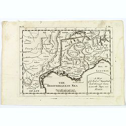
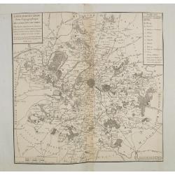
A Map of the Rout which Hannibal took through Gaul & over the Alpes into Italy.
A map showing the (clear) route the North African, Carthaginian General Hannibal took to get from Spain to northern Italy, via France and the Alps. Ancient, Latin names a...
- $40 / ≈ €37
Place & Date: London, 1747
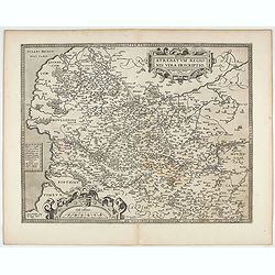
Artois. Atrebatum Regionis Vera Descripto.
Prepared by Jacob Surhon who made a manuscript map of Artois for which he received 36 Livres from Charles V in 1554. For security reasons the map was not published. Only ...
- $500 / ≈ €468
Place & Date: Antwerp, after 1612
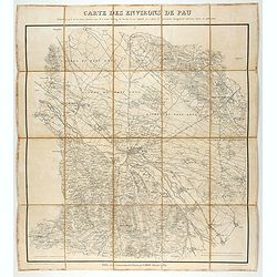
Carte des environs de Pau. . .
Folding map of Pau and its surroundings, being a reduced version of the map by Comte Dulong de Rosnay and engraved by Nicolas Delamare and published by Lafon.More about f...
- $90 / ≈ €84
Place & Date: Pau, Lafon, 1840-1850
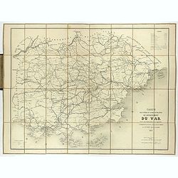
Carte routière et administrative du département du Var dressée sous l'administration et l'approbation de M. Montois, officier de la légion d'honneur, préfet , par J.B CHABET.
Folding-map of the Maritime Alps, and the Mediterranean coastline of Fréjus, Ramatuelle, St Tropez, Toulon. Engraved by Erhard, geographer and engraver (1821-1880) at th...
- $150 / ≈ €140
Place & Date: Paris, 1865
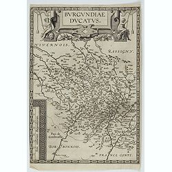
Burgundiae Ducatus.
Map of Burgundy region without text on the verso. Second state with the date 1597 removed from the title cartouche. This is the rarest Burgundy map of the four that Ortel...
- $500 / ≈ €468
Place & Date: Antwerp, after 1612
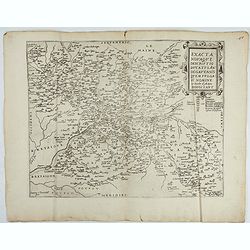
Exacta novaqve descriptio dvcatvs Andegravensis qvem vvlgari nomine Le Duche d'Aniou Indigitant.
Centered on the town of Angiers. From the first edition of De Jode's Speculum Orbis Terrarum, the second general atlas of the world, after Ortelius. Engraved by Ioannes V...
- $750 / ≈ €702
Place & Date: Antwerp, 1578
1) Caletensivm et Bononiensivm..2) Veromandvorvm eorvmque..
Prepared by Jean Surhon, cartographer, goldsmith and engraver. From 'Theatrum Orbis Terrarum [Atlas of the Whole World]': published in Antwerp.
- $200 / ≈ €187
Place & Date: Antwerp, 1580
Carte des Pais Bas contenant la Flandre, le Brabant, Pais de Liege. . .
Map sheet from a multi-sheet map of the Low Countries, showing a large title cartouche and part of the Northern French coast line around Calais, Duinkerken and Furnes. Th...
- $75 / ≈ €70
Place & Date: Paris, 1742

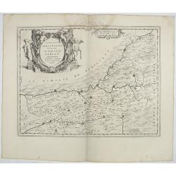
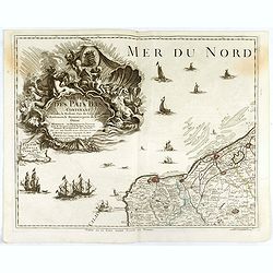
Beschrijvinge vande de zee Cuften va Vlanderen en Picardien. . .
A detailed description of the coast of Picardie and Normandy decorated by a large colored baroque title cartouche, and the coat of arms of Flanders with a colorful scale ...
- $1750 / ≈ €1638
Place & Date: Amsterdam, 1585
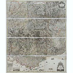
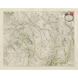
Theatre de la Guerre en Savoie et en Piémont - Le Dauphiné, La Bresse - Partie du Lionnois et de la Provence./ Theatre de la guerre en Dauphiné et en Provence…
Rare wall map of the Savoie/Piémont and Dauphiné/Provence region. Decorated with 2 title-cartouches, one at upper right part (Savoye/Piémont) and one at lower right pr...
- $3000 / ≈ €2807
Place & Date: Amsterdam, c.1735
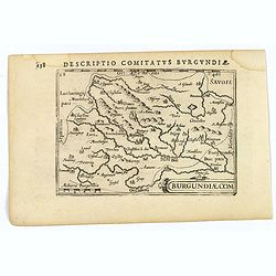
Descriptio Comitatus Burgundiae.
A decorative small map of region around Dijon, Halons and Dole in Burgundy. Features a nice strap-work title, shows rivers and settlements. From the Bertius atlas Tabular...
- $100 / ≈ €94
Place & Date: Amsterdam, 1606
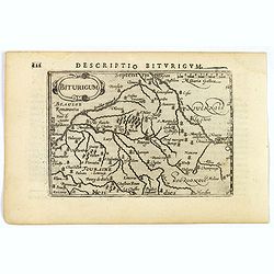
Descriptio Biturigum.
A charming small map of central France. Showing the areas around the rivers Loire, Auron, Allier and Yevre. Nevers and Bourges depicted. From the Bertius atlas Tabularum ...
- $100 / ≈ €94
Place & Date: Amsterdam, 1606
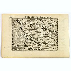
Descriptio Pictaviae.
A charming small map of Poitou in west central France. Showing Cognac, Limoges, Perigord, Poitiers and Angouleme. From the Bertius atlas Tabularum geographicarum contract...
- $100 / ≈ €94
Place & Date: Amsterdam, 1606
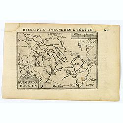
Descriptio Burgundiae Ducatus.
A decorative small map of region around Dijon, Chalons and Dole in Burgundy. Shows many rivers including the Seine, Saone and Brune. It features a nice strap-work title, ...
- $100 / ≈ €94
Place & Date: Amsterdam, 1606
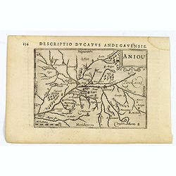
Aniou.
Anjou is a historical province of France, straddling the lower Loire River. Its capital was Angers. It bordered Brittany to the west, Maine to the north, Touraine to the ...
- $100 / ≈ €94
Place & Date: Amsterdam, 1606
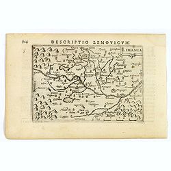
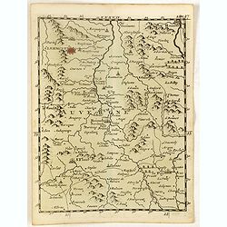
Limania.
A pleasant miniature map of the Limousin region of central France, the area surrounding Clermont Ferrand. Good map detail. From the Bertius atlas Tabularum geographicarum...
- $100 / ≈ €94
Place & Date: Amsterdam, 1606
![Venuxinus Comitatus. [Vaucluse]](/uploads/cache/43427-250x250.jpg)
Venuxinus Comitatus. [Vaucluse]
A pleasant miniature map of the Vaucluse region of S.E. France, as published by Petrus Bertius in Amsterdam at the beginning of the seventeenth century. Many mountains as...
- $100 / ≈ €94
Place & Date: Amsterdam, 1606
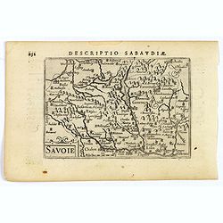
Savoie.
A decorative miniature map of Savoy - a cultural region in Central Europe that comprises roughly the territory of the Western Alps between Lake Geneva in the north and Da...
- $100 / ≈ €94
Place & Date: Amsterdam, 1606
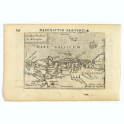
Descriptio Provinciae.
A decorative miniature map of Provence - a geographical region and historical province of south-eastern France, which extends from the left bank of the lower Rhône River...
- $100 / ≈ €94
Place & Date: Amsterdam, 1606