
Paris, Lutetia, Parisii, Ville Capitale du Royaume de France.
View of Paris seen from the hill "Belleville based on that of Merian (1616) but updated with the new gates Saint-Denis and Saint-Martin. With a key 1-78 and A-Z. Sur...
Place & Date: Paris, after 1676
![S. Laurens in Franckr. [France].](/uploads/cache/13810-250x250.jpg)
S. Laurens in Franckr. [France].
A very nice view of the town of Saint Laurens in Alsace, with a church. On the foreground, an elephant and a rhinoceros are depicted. With a verse in two languages undern...
- $40 / ≈ €37
Place & Date: Frankfurt, 1623-1678
![Cordelirs in Franckr. [France].](/uploads/cache/13812-250x250.jpg)
Cordelirs in Franckr. [France].
A panoramic view of the town of Cordeliers (probably imaginary) with in the center the church. In the foreground a man hunting a wolf. With a verse in two languages under...
- $50 / ≈ €47
Place & Date: Frankfurt 1623-1678
![Cordelirs in Franckr. [France].](/uploads/cache/13811-250x250.jpg)
Cordelirs in Franckr. [France].
A panoramic view of the town of Cordelirs (probably imaginary) with in center the church. On the foreground a man hunting a wolve. With a verse in two languages underneat...
- $35 / ≈ €33
Place & Date: Frankfurt 1623-1678
![Cordelirs in Franckr. [France].](/uploads/cache/13736-250x250.jpg)
Cordelirs in Franckr. [France].
A very nice view of a monastery. With a verse in two languages underneath the picture.The poet and topographer from Comothau, Daniel Meisner (1585-1625), started his firs...
- $40 / ≈ €37
Place & Date: Frankfurt, 1623-1678
![In einem Todt. . . [ Chateau Chenonceaux ]](/uploads/cache/13817-250x250.jpg)
In einem Todt. . . [ Chateau Chenonceaux ]
A very nice depiction of Chateau Chenonceaux near Tours, France within the foreground is a dead lion, surrounded by rabbits. With a verse in two languages underneath the ...
- $70 / ≈ €66
Place & Date: Frankfurt, 1623-1678
![Cordelirs in Franckr. [France].](/uploads/cache/13799-250x250.jpg)
Cordelirs in Franckr. [France].
A very nice view of the town of Cordeliers. On the foreground, a man hunting a wolf is depicted. With a verse in German and Latin underneath the picture.The poet and topo...
- $80 / ≈ €75
Place & Date: Frankfurt, 1623-1678
![S. Victor in Franckr. [The Abbey of St. Victor near Paris.].](/uploads/cache/13769-250x250.jpg)
S. Victor in Franckr. [The Abbey of St. Victor near Paris.].
A very nice view of the Abbey of St. Victor near Paris. On the foreground, a night watchman is depicted. With a verse in two languages underneath the picture.The poet Dan...
- $60 / ≈ €56
Place & Date: Frankfurt, 1623-1678
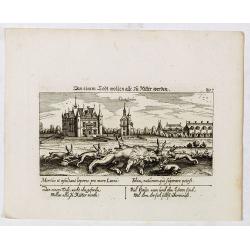
In einem Todt wollen alle zu Ritter werden.
A very nice view of a dead lion, surrounded by rabbits and in the background a French castle. With a verse in two languages underneath the picture. "In einem Todt, n...
- $70 / ≈ €66
Place & Date: Frankfurt, 1623-1678
![S. Victor in Franckr. [France].](/uploads/cache/13770-250x250.jpg)
S. Victor in Franckr. [France].
A very nice view of the church. On the foreground, a night watchman is depicted. With a verse in two languages underneath the picture.The poet and topographer from Comoth...
- $40 / ≈ €37
Place & Date: Frankfurt, 1623-1678
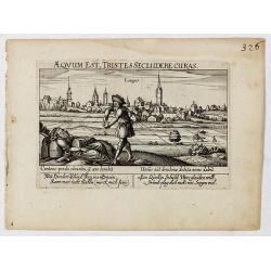
Aeqvum est, tristes secludere curas (Lianges.)
A very nice view of the city Lianges. With a verse in two languages underneath the picture.The poet and topographer from Comothau, Daniel Meisner (1585-1625), started his...
- $60 / ≈ €56
Place & Date: Frankfurt, 1623-1678
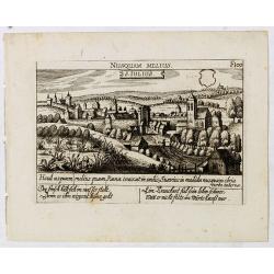
S. Iulius.
A very nice view of the castle of Saint Julius. On the foreground, several frogs are depicted. With a verse in two languages underneath the picture.The poet and topograph...
- $60 / ≈ €56
Place & Date: Frankfurt, 1623-1678
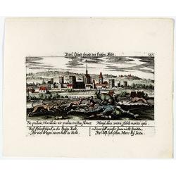
Vincennes - Viel hund Feind.des Hasen Todt.
A very nice picture representing Vincennes. With a verse in German and Latin. The German text reads : "Viel Hundt feind ja des Hasen Todr, Ihr viel bringn einen bald...
- $70 / ≈ €66
Place & Date: Frankfurt, 1623-1678
![S. Victor in Franckr. [Paris].](/uploads/cache/13781-250x250.jpg)
S. Victor in Franckr. [Paris].
A very nice view of St. Victor church in Paris. In the foreground, a night watchman is depicted. With a verse in Latin and German underneath the picture. The German text ...
- $60 / ≈ €56
Place & Date: Frankfurt, 1623-1678

Veue de la Ville, et du Port de Calais, di côte de la terre.
Showing the town of Calais; landscape with, in the left foreground, group of cavalrymen led by an officer and going to right, at right two soldiers walking alongside a ca...
Place & Date: Paris, ca. 1680
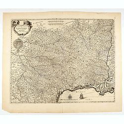
Gouvernement General de Languedoc. Divise en ses Vint Deux Diocesez.
A lovely late seventeenth century map of the central south French region of Languedoc, part of which borders the Mediterranean Sea by Dutch publisher and cartographer, Fr...
- $250 / ≈ €234
Place & Date: Amsterdam, ca 1680

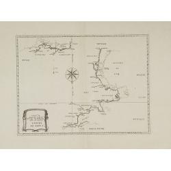
The Sea Coast of France from Ushent to Olone.
Chart showing the Brittany coast from Ushent to Ollone, with Belle-Ile. In insets : Rade de Brest and Mouth of the Loire between St. Nazaire and Nantes.Originally engrave...
Place & Date: London, ca. 1680

The Sea Coasts of France from Olone to Cape Machicaca in Biscay . . .
Detailed chart of Biscay Bay, showing the Coast of Brittany. The chart is oriented with north-east at the top and includes two large insets of the Loire River with Nantes...
Place & Date: London, ca. 1680
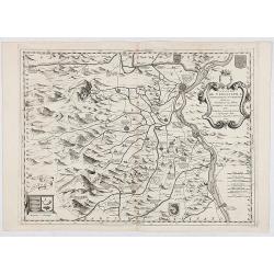
![Rumiliacum vulgo Rumilix. [Rumilly]](/uploads/cache/45513-250x250.jpg)
Rumiliacum vulgo Rumilix. [Rumilly]
Showing in great detail a bird's-eye view of the city of Rumilly in the Haute-Savoie, decorated with the coat of arms and a lettered key.From "Theatrum Sabaudiæ&quo...
- $150 / ≈ €140
Place & Date: Amsterdam, 1682
![Abbaye d'Hautecombe. [Hautecombe Abbey]](/uploads/cache/45512-250x250.jpg)
Abbaye d'Hautecombe. [Hautecombe Abbey]
Showing in great detail a bird's-eye view of the Hautecombe Abbey, a former Cistercian monastery, later a Benedictine monastery, in Saint-Pierre-de-Curtille near Aix-les-...
- $150 / ≈ €140
Place & Date: Amsterdam, 1682
![France en general. [de l'Europe / Figure LXVII] 147](/uploads/cache/38437-250x250.jpg)
France en general. [de l'Europe / Figure LXVII] 147
A fine and uncommon early 17th century map of France.From the French text edition of "Description d'Univers", 1683. by Allain Manneson Mallet (1630-1706), a wel...
- $30 / ≈ €28
Place & Date: Paris, 1683
![Carte generale de France. [de l'Europe]](/uploads/cache/38442-250x250.jpg)
Carte generale de France. [de l'Europe]
A fine and uncommon early 17th century map of France printed from two copper plates. Engraved by Liébaux.From the French text edition of "Description d'Univers"...
- $80 / ≈ €75
Place & Date: Paris, 1683
![De l'Europe. [ Figure LXXXV].](/uploads/cache/38452-250x250.jpg)
De l'Europe. [ Figure LXXXV].
Decorative engraving showing "Ludovicus Magnus" or Louis XIV King of France, Coin Portrait.From the French text edition of "Description d'Univers", 16...
- $50 / ≈ €47
Place & Date: Paris, 1683
![Ancienne Gavle. [de l'Europe]](/uploads/cache/38440-250x250.jpg)
Ancienne Gavle. [de l'Europe]
A fine and uncommon early 17th century map of France.From the French text edition of "Description d'Univers", 1683. by Allain Manneson Mallet (1630-1706), a wel...
- $50 / ≈ €47
Place & Date: Paris, 1683

Citta, porto, e rada di Brest, e . . . Nella Bretagna . . .
A beautiful and rare map of Bretagne. In top right an inset with the town of Brest.The remarkable Vincenzo Coronelli (1650-1718), encyclopaedist, geographer, inventor and...
Place & Date: Venice, 1690

Isola d'Oleron, nella piaggie occidentali della Francia.
A beautiful and rare map showing île d'Oleron.The remarkable Vincenzo Coronelli (1650-1718), encyclopaedist, geographer, inventor and Doctor of Theology, was citizen of ...
Place & Date: Venice, 1690
Le Coste della Francia sul Mare Oceano.
Uncommon map from "Mercurio Geografico", published in Rome by G. de Rossi. A decorative title and scale cartouches enriching the map. The Italian cartographer C...
- $375 / ≈ €351
Place & Date: Rome, 1690
Isola del Re Nel Mare di Guascogna . . .
A beautiful map showing Ile de Ré in Bretagne, located in the Bay of Biscay off the coast of France, from Vincenzo Coronelli's Corso Geografico Universale.Italian text o...
Place & Date: Venice, 1690
Isola d'Oleron, nella piaggie occidentali della Francia.
A beautiful and rare map showing île d'Oleron.The remarkable Vincenzo Coronelli (1650-1718), encyclopaedist, geographer, inventor and Doctor of Theology, was citizen of ...
Place & Date: Venice, 1690
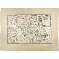
Partie Septentrionale de l'Evesché de Poictiers. Partie Septentrionale du Haut Poitou.
Rare map engraved by R. Michault and published "a Paris chez Greg. Mariette sur le quay de l'Horloge au dessus de la cour de Lamoignon". Dedicated to the Bishop...
- $125 / ≈ €117
Place & Date: Paris, 1690
Contado DE Venassino, E prencipato d'Oranges . . .
A most attractive and decorative map centered on Avignon and Orange, by Vincenzo Coronelli. An elaborate title cartouche garlanded with intertwined flowers and dedicated ...
- $400 / ≈ €374
Place & Date: Venise 1690

Gouvernement general de Champagne. . .
Fine map of Champagne with a decorative title and scale cartouche.Alexis-Hubert Jaillot (1632-1712), was a French cartographer. He joined the Sanson heirs and redrew Nico...
Place & Date: Amsterdam, 1692
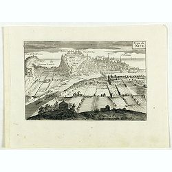
Veüe de Nice.
Engraved birds eye view of Nice. Shows rivers, canals, bridges, landmarks, farms and buildings. Relief shown pictorially.
Place & Date: Paris, 1692
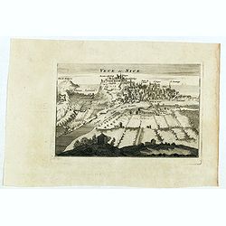
Veue de Nice.
Engraved birds eye view of Nice. Shows rivers, canals, bridges, landmarks, farms and buildings. Relief shown pictorially.
Place & Date: Paris, 1692
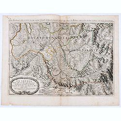
La Savoia divisa nelle sue Principali Provincie da Giacomo Cantelli da Vignola . . .
Late 17th century maps of the Savoy region, based on the reports of Giacomo Cantelli da Vignola and published in Roma in Giacomo de Rossi's world atlas Mercurio Geografic...
- $250 / ≈ €234
Place & Date: Rome, 1692
![[Lot of 15 maps/plans of northern France] Gouvernement d' Orleans et la Generalite divisee en ses Elections.](/uploads/cache/19853-250x250.jpg)
[Lot of 15 maps/plans of northern France] Gouvernement d' Orleans et la Generalite divisee en ses Elections.
Alexis-Hubert Jaillot (1632-1712), French cartographer. He joined the Sanson heirs and redrew Nicolas Sanson's maps on a larger scale. 'Atlas Nouveau' (1674), sea-atlas '...
- $500 / ≈ €468
Place & Date: Amsterdam, Paris, 1693

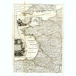
Le comte d'Artois dresse sur les memoires les plus nouveaux. . .
Map showing the north of France, showing St Omer, and Arras, etc. The map notes Nicolas Sanson as the mapmaker and claims that the map was published by Alexis-Hubert Jail...
Place & Date: Amsterdam, 1693

ANTIBES, Ville et Port de Mer de Provence, sur la Mer Mediterranée.
Early plan of Antibes. From his "Introduction à la fortification".
Place & Date: Paris, 1693

St Tropez.
Early plan of St.Tropez. From his "Introduction à la fortification".
Place & Date: Paris, 1693
Carte de France corrigée par ordre du Roy sur les observations de Messieurs de l'Académie des Sciences
Important map published by the Academy of Sciences. The new projection method was based on the necessary to define the exact contours of the country and to develop the me...
- $3000 / ≈ €2807
Place & Date: Paris, 1693