
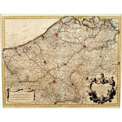
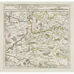
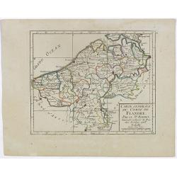
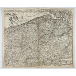
Comitatus Flandria.
A highly decorative map with in the left and right top corners the pictures of archduke Albert of Austria and Isabella, queen of Spain. In the left and right borders cost...
Place & Date: Amsterdam, 1648
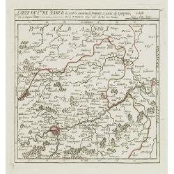
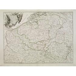
Comitatus Namurci Tabula in Lucem. . .
Centered on Namen, with decorative title cartouche upper right.
Place & Date: Amsterdam, 1680
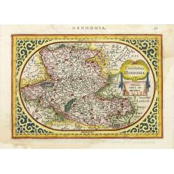
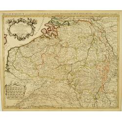
Comitatus Hannonia.
Detailed map of the Belgium province Hainault or Henegouwen. Including the towns of Mons, Geraadsbergen, etc.Uncommon and decorative oval map in a rectangular frame, the ...
- $100 / ≈ €94
Place & Date: Amsterdam, 1616
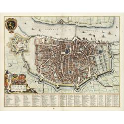
Antverpia, Gallis Anvers. Vernacule Antwerpen.
Detailed plan of the city of Antwerp with extensive key to principal buildings. Lower left title cartouche with two coats of arms and Mercurius.
Place & Date: Amsterdam, 1649
Des Hochstifts Luttich..
Uncommon map covering the area of Limburg in present day Belgium. Also including western borderline of the Dutch province of Limburg.
- $125 / ≈ €117
Place & Date: Vienna, 1791

Novissima Flandriae Comitatus tabula. . .
Rare issue of Theodorus Danckert's attractive map of eastern Belgium provinces, Flanders, with Brugge, Oostende, Gent, Mons, Antwerp, Cambray, etc..Decorative title carto...
Place & Date: Amsterdam, 1700
![No title. [Flanders]](/uploads/cache/12185-250x250.jpg)
No title. [Flanders]
Map depicting eastern part of Flemish Flanders.
- $200 / ≈ €187
Place & Date: Amsterdam, 1630
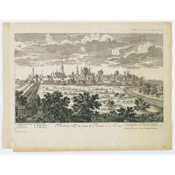
Namur.
A very RARE panoramic of the city of Namur, with a numbered legend in both lower corners.The plate is numbered in red pencil in upper right corner.Engraved by Pierre Avel...
- $150 / ≈ €140
Place & Date: Paris, 1690-1720
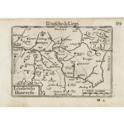
Leodiensis Dioecesis.
A miniature map of the southern part of Belgium centered on Liege. The title cartouche on the lower left corner.First published in 1598 in his Caert-Thresoor, the plates ...
- $75 / ≈ €70
Place & Date: Amsterdam / Frankfurt, 1609
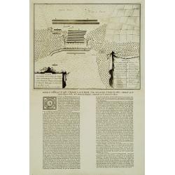
Plan De l'Action.. Auprès de Wynendale le 28 Sept. 1708.
Rare broadside sheet representing a conventional battle plan near the town of Torhout with the Castle Wynendale. The plan depicts the situation of 28 september 1708. Incl...
Place & Date: Bruxelles, c.1708
Carte du Comté de Flandre, Dressée sur differens. . .
Large, detailed map of the Flanders including the French Flemish-speaking area. Shows illustrated topography with notations about towns, roads, fortresses, abbeys, monast...
- $100 / ≈ €94
Place & Date: Amsterdam, c. 1745
Carte Des Pays Bas Catholiques Dressée. . .
Topographically detailed map that extends from Paris to Metz and north into Holland. Details include roads and scores of villages. Two decorative cartouches: one with fig...
- $150 / ≈ €140
Place & Date: Amsterdam, c. 1745
Il Paesi Bassi Austriaci, che comprendono parte delle Flandre, del Haynault, e del Brabante.
Uncommon map of Flanders and Brabant in present-day Belgium. Embellished with a nice title-cartouche. Engraved by G.Pitteri after G.Zuliani.From his Atlante Novissimo, il...
- $140 / ≈ €131
Place & Date: Venice, 1784
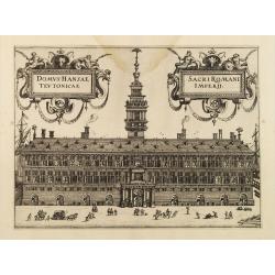
Domus Hansae Teutonicae / Sacri Romani Imperii. (Antwerp townhall)
From Ludovico Guicciardini.'s description of the Netherlands "Beschrijvinghe van alle de Nederlanden anderssins ghenoemt Neder-Duytslandt", published by Willem ...
- $100 / ≈ €94
Place & Date: Amsterdam, 1612
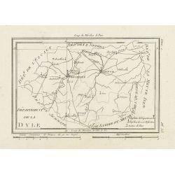
Département de la Dyle.
Map centered on Bruxelles with a short key list in the lower right corner. From Atlas de la Géographie de toutes les parties du monde .. Ouvrage destiné pour l'educatio...
- $40 / ≈ €37
Place & Date: Paris, Prudhomme, Levrault, Debray, 1806
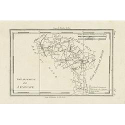
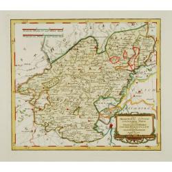
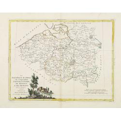
Département de Jemmape.
Map representing the area around Mons, with a short key list in the lower right corner.From Atlas de la Géographie de toutes les parties du monde .. Ouvrage destiné pou...
- $30 / ≈ €28
Place & Date: Paris, Prudhomme, Levrault, Debray, 1806
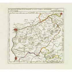
I. Carte du D.ché de Luxembourg ou sont les Frontieres du Namurois et du Lyegeois.
Charming small map representing part of the Walloon Region, delimited by the towns of Namur, Huy, Dinant and Ciney.From Atlas Portatif Universel, by Robert de Vaugondy. E...
Place & Date: Paris, later than 1749
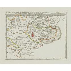
VI. Carte du Duché de Limbourg où sont les environs de Limbourg.
Attractive small map showing part of the Wallon region, centered on Limburg. Dated 1748. From Atlas Portatif Universel, by Robert de Vaugondy.Page 15f outside border top ...
- $45 / ≈ €42
Place & Date: Paris, 1748
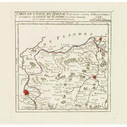
I. Carte du Comté du Haynaut.. Tournay.
Attractive small map encompassing part of Hainaut, between Tournai and Ath. From Atlas Portatif Universel, by Robert de Vaugondy.Edited by : "Au dépôt de Géograph...
- $40 / ≈ €37
Place & Date: Paris, 1799
V. Carte des C.tes de Haynaut et de Namur. . .
Attractive small map illustrating part of the Walloon Region, centered on Charleroi. From Atlas Portatif Universel, by Robert de Vaugondy.Unrecorded state with erased dat...
- $30 / ≈ €28
Place & Date: Paris, after 1748
VI. Carte du C.té de Namur où sont les environs de Namur.. Huy.
Attractive small map illustrating part of the Walloon Region, between Namur and Huy. From Atlas Portatif Universel, by Robert de Vaugondy.Unrecorded state with erased dat...
- $50 / ≈ €47
Place & Date: Paris, after 1748
X. Carte du Comté de Namur où se trouvent les environs de Dinant.
Attractive small map showing an area straddling the border between France and Belgium.It shows Dinant, Ciney, and the fort of Charlemont, built by Charles V on the French...
- $30 / ≈ €28
Place & Date: Paris, 1799
![[IV.] Carte du Brabant où se trouvét la Mairie de Santhoven.. Ryen.](/uploads/cache/24684-250x250.jpg)
[IV.] Carte du Brabant où se trouvét la Mairie de Santhoven.. Ryen.
Nice small map encompassing an area which straddles the border between Belgium and the Netherlands.Showing Antwerp in the central lower part. From Atlas Portatif Universe...
Place & Date: Paris, later than 1748
Selling price: $70
Sold in 2008
V. Carte du Brabant ou se trouvét les Mair.s d'Herentals.. Hochstraten.
Nice small map illustrating the northeastern part of the Flemish region. Centered on Turnhout.From Atlas Portatif Universel, by Robert de Vaugondy. Unrecorded state with ...
- $50 / ≈ €47
Place & Date: Paris, later than 1748
![[IX.] Carte du Brabant ou sont les Mairies de Roo, de Nivelle, de Hulpen, et de Geneppe.](/uploads/cache/24689-250x250.jpg)
[IX.] Carte du Brabant ou sont les Mairies de Roo, de Nivelle, de Hulpen, et de Geneppe.
Nice small map straddling the Flemish and the Walloon regions. It shows Halle, Nivelles, La Hulpe, Overijse, Genappe, etc.From Atlas Portatif Universel, by Robert de Vaug...
Place & Date: Paris, later than 1749
![[X.] Carte du Brabant où sont les environs de Tillemont, de Judoigne, de Gemblours &c.](/uploads/cache/24690-250x250.jpg)
[X.] Carte du Brabant où sont les environs de Tillemont, de Judoigne, de Gemblours &c.
Nice small map straddling the Flemish and the Walloon regions. Extending North to South from Tienen to Gembloux.From Atlas Portatif Universel, by Robert de Vaugondy. Unre...
- $30 / ≈ €28
Place & Date: Paris, later than 1748
I. Carte du Comté de Flandre où sont les env.s de l'Ecluse, d'Ardenburg.. &c.
Nice small map illustrating the southwestern most part of Zeeland. Centered on Sluis. Showing Aardenburg and Vlissingen. Dated 1768.From Atlas Portatif Universel, by Robe...
Place & Date: Paris, later than 1748
Selling price: $100
Sold in 2008
Partie meridionale des Pays Bas.. Cambrefis et Artois.
Finely and crisply engraved map of Belgium, including southern part of Netherlands and part of Germany.Venetian edition of Giles Didier Robert De Vaugondy's map from Atla...
Place & Date: Venice, 1776 - 1784
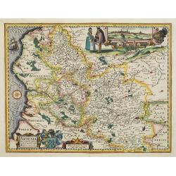
Artesia descriptio.
Very rare. The map is dated 1624 which is unknown to Van der Krogt. Très rare, Van der Krogt ne signale pas cette édition de 1624, qui est postérieure à la dernières...
Place & Date: Amsterdam, 1624
![Anverpia, nobile in Barbantia oppidum, parrim maritimum . . . [Antwerp]](/uploads/cache/26518-250x250.jpg)
Anverpia, nobile in Barbantia oppidum, parrim maritimum . . . [Antwerp]
The bird's-eye plan provides an excellent view of the citadel, city, docks and fortifications. The city was defended by a line of fortification and a moat constructed und...
Place & Date: Cologne, 1585
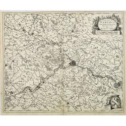
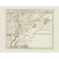
Comitatus Namurci Emendata Delineatio, Nuperrimè in lucem edita, per Nicolaum Visscher.
Detailed engraved map of the province of Namur (Namen), showing cities including Charleroi and Dinant., towns, rivers and lakes. Decorative cartouche with putti. Explanat...
Place & Date: Amsterdam, 1684
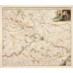
Comitatus Flandriae Tabula, In Lucem Edita A Frederico De Wit.
Double page map of Flanders, the whole Belgian region northwest of Brussels, confined by Antwerp, Brussels, valenciennes, Arras, St. Omer and the Channel. Title heading a...
- $100 / ≈ €94
Place & Date: Amsterdam, 1680
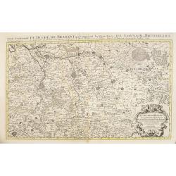
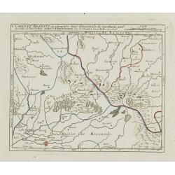
Partie meridionale du Duché de Brabant comprend les Quartiers de Louvain et Brusselles. . .
Fine map of the Duchy of Belgium Brabant with a figurative armorial cartouche and small scale of miles. Boundaries outlined in hand color. The map is fully and richly eng...
- $250 / ≈ €234
Place & Date: Amsterdam, 1692
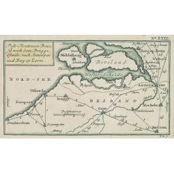
Post-Route von Brüssel nach Gent, Brügge, Ostende, nach Antwerpen und Bergen op Zoom. N°XXIII
Very rare post route maps map centered on Gent, and showing the postal routes in-between Oostende, Bruges, Gent, Brussels, Mechelen, Lier, Antwerp, Bergen op Zoom, etc. f...
- $250 / ≈ €234
Place & Date: Nürnberg, Weigel and Schneider, ca.1785
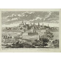
Mons ville capitale du Heynaut, prise sur les Espagnols par Louis le Grand Roy de France. . .
A very decorative and extremely raretown-viewof Mons. Engraved by Pierre-Alexandre Aveline. With "fait par Aveline avec privilege du Roy" in lower right margin....
- $150 / ≈ €140
Place & Date: Paris, ca.1692
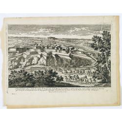
Charleroy place forte du Comte de Namur pres de la Riviere de Sambre. . .
A very decorative and extremely rare town-view of Charleroi. Engraved by Pierre-Alexandre Aveline. With "fait par Aveline avec privilege du Roy" in lower margin...
- $150 / ≈ €140
Place & Date: Paris, ca.1792
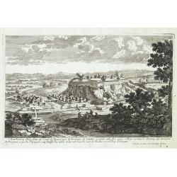
Charleroy place forte du Comte de Namur. . .
A very decorative and extremely rare town-view of Charleroi. Engraved by Pierre-Alexandre Aveline. With "Fait par Aveline avec privilege du Roy" in lower right ...
- $150 / ≈ €140
Place & Date: Paris, ca.1692
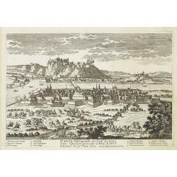
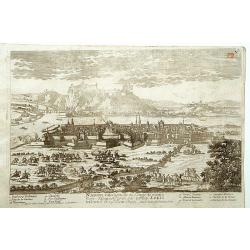
Namur Ville Capitale du Comté de même nom. Elle a este prise par le Roy LOUIS le Grand le 29e Juin 1692.
A very decorative and extremely rare town-view >of Namur, including a numbered key (1-12) in lower part. Engraved by Pierre-Alexandre Aveline. With "fait par Avel...
- $150 / ≈ €140
Place & Date: Paris, ca.1692
Furnes Ville du comté de Flandre à la France.
A very decorative and extremely raretown-viewof Veurne, including a numbered key (1-10) in lower part. Engraved by Pierre-Alexandre Aveline. With "fait par Aveline a...
- $220 / ≈ €206
Place & Date: Paris, ca.1692
![Flandra parte occidentale: dedicata all'illustrissimo et eccelententissimo S. Giorgio Cocco, senatore meritissimo. . . [together with] Zelanda e Parte Orientale della Flandra. . . .](/uploads/cache/31286-250x250.jpg)
Flandra parte occidentale: dedicata all'illustrissimo et eccelententissimo S. Giorgio Cocco, senatore meritissimo. . . [together with] Zelanda e Parte Orientale della Flandra. . . .
Wall sized map of two joined sheets of Flanders, the coastline running from Calais to Zeeland in the Netherlands. Including major cities along the coast such as Dunkerque...
Place & Date: Venice, 1696