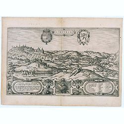
Lympurch. (Limburg)
Very desirable and early town-plan of the city of Limburg in Belgium with its fortifications at the end of the 16th century.From volume one of the greatest publication in...
- $250 / ≈ €234
Place & Date: Cologne, 1575
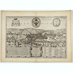
Leodium. (Luik or Liège)
Very desirable and early town-view of Liège, which shows the city with the Meuse flowing in its favorable location amongst gentle hills, sturdy trees and fertile fields....
- $300 / ≈ €281
Place & Date: Cologne, (1572) 1577
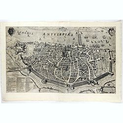
![Anverpia, nobile in Barbantia oppidum, parrim maritimum . . . [Antwerp]](/uploads/cache/26518-250x250.jpg)
Anverpia, nobile in Barbantia oppidum, parrim maritimum . . . [Antwerp]
The bird's-eye plan provides an excellent view of the citadel, city, docks and fortifications. The city was defended by a line of fortification and a moat constructed und...
Place & Date: Cologne, 1585
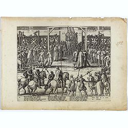
Wie ist das gluck so gar ungleich . . . Plate 18.
Early print showing a hanging in Brabant on 11 February 1620.Plate from the series about the " Eighty Years' War" or the independence war of Holland against Spa...
- $80 / ≈ €75
Place & Date: Cologne, ca. 1590
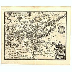
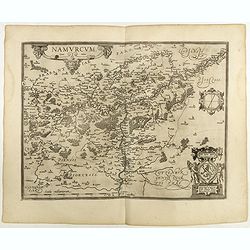
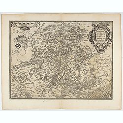
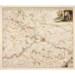
Namurcum Comitatus.
Prepared by Jacques Surhon in 1555. His manuscript map was for security reason not published. Only in 1579, when Antwerp was independent for a short time, Ortelius used a...
Place & Date: Antwerp, 1598
Namurcum Comitatus.
Prepared by Jacques Surhon in 1555. His manuscript map was, for security reasons not published. Only in 1579, when Antwerp was independent for a short time, Ortelius used...
Place & Date: Antwerp, 1598
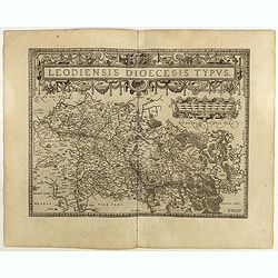
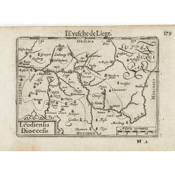
Leodiensis Diocesis Typus.
East to the top. Centered on Liege, including the southern part of Dutch Limburg. Prepared by Jan van Schille.Dare to go in Black. All early maps were printed in black an...
Place & Date: Antwerp, 1598
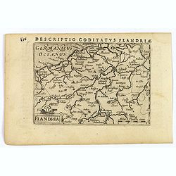
Flandria.
A lovely set of miniature map of Flanders. With an attractive strap-work title, and with detailed topography and information. Bertius (1565-1629) was a Flemish cartograph...
Place & Date: Amsterdam, 1606
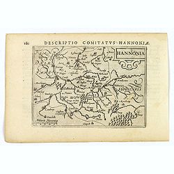
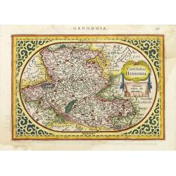
Hannonia.
An attractive miniature map of the Belgian, region of Hainaut, published by Petrus Bertius, in Amsterdam at the beginning of the seventeenth century. It features a small ...
Place & Date: Amsterdam, 1606
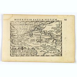
Descriptio Galliae Belgicae.
A decorative miniature map of a section of ancient France, and that of Belgium. Features a nice strap-work title, shows rivers and settlements. From the Bertius atlas Tab...
- $100 / ≈ €94
Place & Date: Amsterdam, 1606
Leodiensis Dioecesis.
A miniature map of the southern part of Belgium centered on Liege. The title cartouche on the lower left corner.First published in 1598 in his Caert-Thresoor, the plates ...
- $75 / ≈ €70
Place & Date: Amsterdam / Frankfurt, 1609
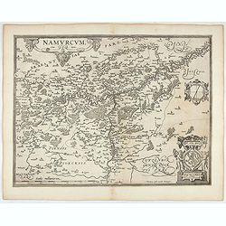
Namurcum Comitatus.
Prepared by Jacques Surhon in 1555. His manuscript map was for security reason not published. Only in 1579, when Antwerp was independent for a short time, Ortelius used a...
- $500 / ≈ €468
Place & Date: Antwerp, after 1612

Flandria.
Very decorative, egg-shaped map. This is the last and very rare third state with the signature Theodorus Galle. The fortifications along the Scheldt River are added and t...
- $1000 / ≈ €936
Place & Date: Antwerp, after 1612
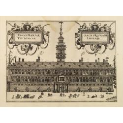
Domus Hansae Teutonicae / Sacri Romani Imperii. (Antwerp townhall)
From Ludovico Guicciardini.'s description of the Netherlands "Beschrijvinghe van alle de Nederlanden anderssins ghenoemt Neder-Duytslandt", published by Willem ...
- $100 / ≈ €94
Place & Date: Amsterdam, 1612
Comitatus Hannonia.
Detailed map of the Belgium province Hainault or Henegouwen. Including the towns of Mons, Geraadsbergen, etc.Uncommon and decorative oval map in a rectangular frame, the ...
- $100 / ≈ €94
Place & Date: Amsterdam, 1616

Marchionatus Sacri Romani Imperii.
A wonderfully decorative map showing in the middle of the image a town plan from Antwerp and in the lower part an inset with a panoramic view of the city and harbour of A...
Place & Date: Amsterdam, 1617- 1624
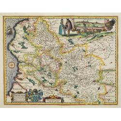
Artesia descriptio.
Very rare. The map is dated 1624 which is unknown to Van der Krogt. Très rare, Van der Krogt ne signale pas cette édition de 1624, qui est postérieure à la dernières...
Place & Date: Amsterdam, 1624
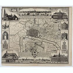
Marchionatus Sacri Romani Imperii.
Plan of the city of Antwerp in Belgium, by Claes Janszoon Visscher and first published by his son. The map is surrounded by 3 city views and 10 building vignettes and inc...
- $1750 / ≈ €1638
Place & Date: Amsterdam 1624

Kaerte van Bergen op Zoom, Steenbergen ende de nieuwe fortificatien gemaeckt tot bevrÿdinge van 't landt van ter Tolen in tjaar 1628.
Very detailed and scarce map showing Bergen Op Zoom, Steenbergen and its surrounding countryside. North to the left side.
- $400 / ≈ €374
Place & Date: Amsterdam, after 1628

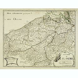
Comitatus Flandria.
First published by the van Langrens c.1595, after his acquisition of the plate, Visscher heavily re-engraved the map, inserting panelled borders on three sides (the lower...
Place & Date: Amsterdam, c. 1630
![No title. [Flanders]](/uploads/cache/12185-250x250.jpg)
No title. [Flanders]
Map depicting eastern part of Flemish Flanders.
- $200 / ≈ €187
Place & Date: Amsterdam, 1630
Nobilis Hannoniae Comitatus Descrip.
Fine map of Hannonia (Hainaut), with ornate cartouches, two coats of arms, etc. Showing the cities of Charleroi, Mons, Ath, Tournay, Valenciennes, Maubeuge, etc. in Belgi...
- $600 / ≈ €561
Place & Date: Antwerp, 1612-1641
Scaldis Antverpia - Locorum Insignium ac viae triumphalis qua ser.mus princeps, Ferdinandus Austriacus, Hispaniar, Infans. etc. Antverpiam est ingressus, designatio . . .
Bird's-eye view of the city of Antwerp and the River Schelde, numbered (1-59 ) with important sites along the entry of the Cardinal Infant Ferdinand of Austria into Antwe...
- $2000 / ≈ €1871
Place & Date: Antwerp, 1635-1641
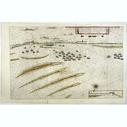
Afbeeldinge vande vermaerde seehaven .. Duynkerken..
Blaeu's map of the coast of the French coast from Duinkerk till Waldamme. In an inset, lower right the continuation till Calais. Many ships offshore Duinkerk, with soundi...
- $500 / ≈ €468
Place & Date: Amsterdam, 1645
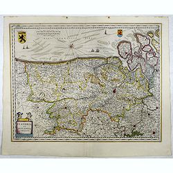
Flandria et Zeelandia Comitatus.
Includes Flanders and Zeeland. The map originally engraved in 1641 for Sanderus 'Flandria Illustrata', was used several times in Blaeu's atlases.More about maps by Willem...
- $250 / ≈ €234
Place & Date: Amsterdam, 1645

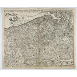
Comitatus Flandria.
A highly decorative map with in the left and right top corners the pictures of archduke Albert of Austria and Isabella, queen of Spain. In the left and right borders cost...
Place & Date: Amsterdam, 1648
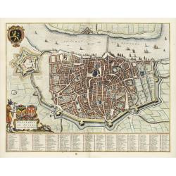
Antverpia, Gallis Anvers. Vernacule Antwerpen.
Detailed plan of the city of Antwerp with extensive key to principal buildings. Lower left title cartouche with two coats of arms and Mercurius.
Place & Date: Amsterdam, 1649
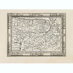
Carte du Comté de Flandre. . .
Decorative map of Flanders from Plans, et Profils des principales villes.. by Ch. De Beaulieu. Etched by mr. Romeijn de Hooghe.
- $80 / ≈ €75
Place & Date: Paris, 1668
Provinces meridionales des Pays-Bas connues sous le nom de Flandres, autrement les Pays-Bas Catholiques . . .
Detailed map of present day Belgium and Luxembourg, dated 1672.More about [+]
- $300 / ≈ €281
Place & Date: Paris, 1672
Le comté de Flandre . . .
Detailed scarce map of the Flanders with fine title cartouche lower right. The map is dated 1675. From a rare plano edition of "Cartes de géographie les plus nouvel...
- $200 / ≈ €187
Place & Date: Paris, 1675
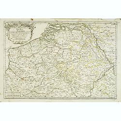
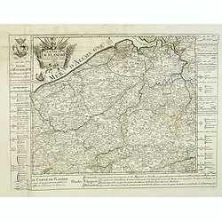
Comitatus Flandriae Tabula, In Lucem Edita A Frederico De Wit.
Double page map of Flanders, the whole Belgian region northwest of Brussels, confined by Antwerp, Brussels, valenciennes, Arras, St. Omer and the Channel. Title heading a...
- $100 / ≈ €94
Place & Date: Amsterdam, 1680
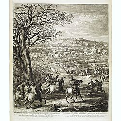
L'armée du Prince d'Orange deffaite devant Mont Cassel par l'armée du Roy, commandée par Monsieur Duc d'Orléans, en 1677.
Showing the town of Cassel. Etching by R. Bonnart after Adam Frans van der Meulen (1632-1690) who was a Flemish Baroque painter specializing in battle scenes. He was acti...
- $500 / ≈ €468
Place & Date: Paris, ca. 1680
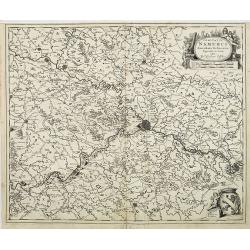
Comitatus Namurci Tabula in Lucem. . .
Centered on Namen, with decorative title cartouche upper right.
Place & Date: Amsterdam, 1680
Comitatus Namurci Emendata Delineatio, Nuperrimè in lucem edita, per Nicolaum Visscher.
Detailed engraved map of the province of Namur (Namen), showing cities including Charleroi and Dinant., towns, rivers and lakes. Decorative cartouche with putti. Explanat...
Place & Date: Amsterdam, 1684
Le Comté de Flandre par P. Placide Augustin. . .
Detailed map of Flanders prepared by P. Placide Augustin, with fine title cartouche and dedication to "Monseigneur Le Marquis de Torcy, Secretaire d'État" in u...
- $350 / ≈ €328
Place & Date: Paris, 1690

Le comte de Namur et partie des Duchez de Brabant. . .
Decorative map centered on Namen and including the towns of Liege, Leuven, Charleroi, Dinant, Luxemburg, etc. by François Jollain (ca. 1641 – 18 April 1704).Rare "...
Place & Date: Paris, c. 1692
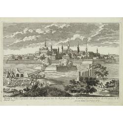
Mons ville capitale du Heynaut, prise sur les Espagnols par Louis le Grand Roy de France. . .
A very decorative and extremely raretown-viewof Mons. Engraved by Pierre-Alexandre Aveline. With "fait par Aveline avec privilege du Roy" in lower right margin....
- $150 / ≈ €140
Place & Date: Paris, ca.1692
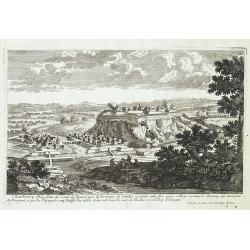
Charleroy place forte du Comte de Namur. . .
A very decorative and extremely rare town-view of Charleroi. Engraved by Pierre-Alexandre Aveline. With "Fait par Aveline avec privilege du Roy" in lower right ...
- $150 / ≈ €140
Place & Date: Paris, ca.1692
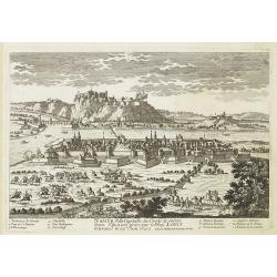
Namur Ville Capitale du Comté de même nom. Elle a este prise par le Roy LOUIS le Grand le 29e Juin 1692.
A very decorative and extremely rare town-view >of Namur, including a numbered key (1-12) in lower part. Engraved by Pierre-Alexandre Aveline. With "fait par Avel...
- $150 / ≈ €140
Place & Date: Paris, ca.1692
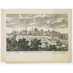
Furnes Ville du comté de Flandre à la France.
A very decorative and extremely raretown-viewof Veurne, including a numbered key (1-10) in lower part. Engraved by Pierre-Alexandre Aveline. With "fait par Aveline a...
- $220 / ≈ €206
Place & Date: Paris, ca.1692