Browse Listings
![Nova & exacta Chorographia Latii sive Territorii Romani iuxta veterem et novum situm parallela nomimu[m] comparatione elaborata.](/uploads/cache/44863-250x250.jpg)
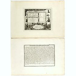
Nova & exacta Chorographia Latii sive Territorii Romani iuxta veterem et novum situm parallela nomimu[m] comparatione elaborata.
Map of central Italy, centered on Rome from "Latium" by A. Kircher and designed by Innocenzo Mattei. The title cartouche in the lower right, small legend with 1...
Place & Date: Amsterdam, 1671
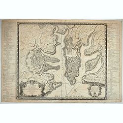
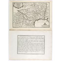
Plan général de la ville capitale de Malte dressé sur les memoires des grands officiers de l'Ordre, dédiée et présentée à S.A.S. Mgr le prince de Conty, prince du sang, grand prieur de France. . .
First edition of this attractive large scale plan of Valetta on Malta. To the left and right a numbered key 1 - 269. In lower left, a title cartouche with a dedication to...
Place & Date: Paris, 1751
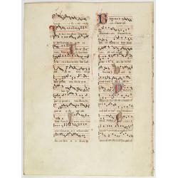
Leaf on vellum from a antiphonary.
A leaf from a Medieval Antiphonal or Choir Missal for Spanish use, in Latin on extremely heavy vellum. Justification: 370x250 mm. Text is in Spanish rounded gothic hand (...
Place & Date: Sevilla, ca.1520
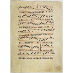
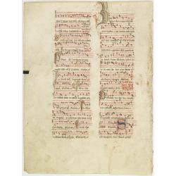
Leaf on vellum from an antiphonary.
A more than 600 years old antiphonary leaf, written in Besançon, in 1370. Musical notation on 4 bars, the staves are in red and the notes in black: numerous pen-flourish...
Place & Date: France, 1370
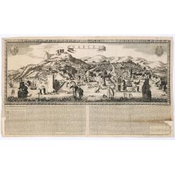
Naples. 1699. Nouvelle et exacte description de la tres-celebre & ancienne Ville de NAPLES
Only recorded broad sheet panoramic view of Naples with underneath in letter press a description of the town's history : "Nouvelle et exacte description de la tres-c...
Place & Date: Paris, 1699
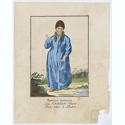
Femme tatares de Tchatsk.
Uncommon copper engraved costume plate from the French translation of Johann Gottlieb Georgi "Beschreibung aller Nationen des Russischen Reichs" (1776), the wor...
Place & Date: St. Petersbourg, C.G. Müller, 1776-1777
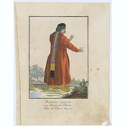
Femme de Tatares Nogais.
Uncommon copper engraved costume plate from the French translation of Johann Gottlieb Georgi "Beschreibung aller Nationen des Russischen Reichs" (1776), the wor...
Place & Date: St. Petersbourg, C.G. Müller, 1776-1777
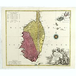
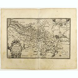
L'isle de Corse avec les différents districts, appartenante à la République de gênes . . .
Map published during the uprising of the Corsican people against the Republic of Genoa. It is decorated with a wind rose compass and a beautiful title cartouche decorated...
Place & Date: Augsburg, 1760
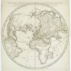
Hémisphère Supérieur de la Mappemonde projetée sur l'Horizon. . .
Hemisphere on a partial polar projection. The Northern Hemisphere (of 2) is centered on Paris emphasizing the continents. Hemisphere measures 24.5. Alaska is shown as an ...
Place & Date: Paris, 1774
-250x250.jpg)
Indian painting on paper.
Fine miniature, presenting a couple in love making position. The miniature has been painted in India in early 20th century. The miniature is 165 x 110 mm, painted in oil ...
Place & Date: India, ca. 1920
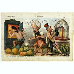
I tre diogene. Papagallo No. 43. Anno V.
Satirical lithographed plate published in the supplement to the political newspaper charivaric Papagallo / Le Perroquet N. 43, in the 5th year, published in Bologna. Sati...
Place & Date: Bologne, 1877
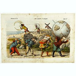
Pesi Graditi ee sgraditi. Papagallo No. 6. Anno VI.
Translation of the legend: "Several weights, each one has to carry its weight, the more serious it is, the longer the trip seems to be, and they will come sooner or ...
Place & Date: Bologne, 1878
Il Don Cihsciotte a complici. Papagallo No. 48. Anno VI.
Taken from the Italian satirical newspaper Il Papagallo, a satirical magazine founded in January 1873 by Augusto Grossi (1835-1919), which specialized in color-printed ca...
Place & Date: Bologne, 1878
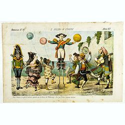
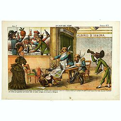
Il bolero in Ispagnia. Papagallo No. 42. Anno VI.
About Spanish expansion, with balloons symbolizing Cuba, Havana, Cortes. Taken from the Italian satirical newspaper Il Papagallo, a satirical magazine founded in January ...
Place & Date: Bologne, 1878
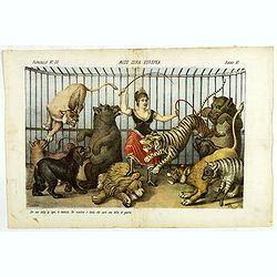
Miss Cora Europea. Papagallo No. 35. Anno VI.
Miss Europa taming the lion (Russia) with other nations shown as animals. Design by Augusto Grossi. Taken from the Italian satirical newspaper Il Papagallo, a satirical m...
Place & Date: Bologne, 1878
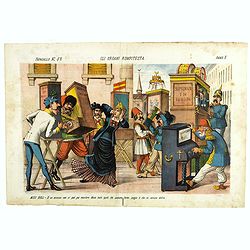
Gli organi rompitesta. Papagallo No. 52. Anno V.
Design by Augusto Grossi. Taken from the Italian satirical newspaper Il Papagallo, a satirical magazine founded in January 1873 by Augusto Grossi (1835-1919), which speci...
Place & Date: Bologne, 1877
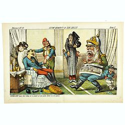
Ultimi momenti di Don Carlos. Papagallo No. 33. Anno II.
Design by Augusto Grossi. Taken from the Italian satirical newspaper Il Papagallo, a satirical magazine founded in January 1873 by Augusto Grossi (1835-1919), which speci...
Place & Date: Bologne, 1874
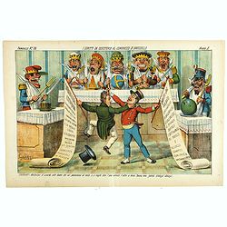
I diritti da discutersi al congresso di Brusselle. Papagallo No. 32. Anno II.
Design by Augusto Grossi. Taken from the Italian satirical newspaper Il Papagallo, a satirical magazine founded in January 1873 by Augusto Grossi (1835-1919), which speci...
Place & Date: Bologne, 1874
L'Orsa Balla. Papagallo No. 30. Anno II.
Design by Augusto Grossi. Taken from the Italian satirical newspaper Il Papagallo, a satirical magazine founded in January 1873 by Augusto Grossi (1835-1919), which speci...
Place & Date: Bologne, 1874
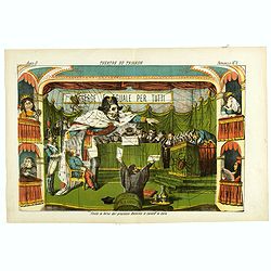
Theatre du Trianon. Papagallo No. 2. Anno II.
Design by Augusto Grossi. Taken from the Italian satirical newspaper Il Papagallo, a satirical magazine founded in January 1873 by Augusto Grossi (1835-1919), which speci...
Place & Date: Bologne, 1874
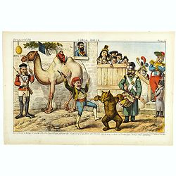
Un Posto mal fermo. Papagallo No. 5. Anno II.
Design by Augusto Grossi. Taken from the Italian satirical newspaper Il Papagallo, a satirical magazine founded in January 1873 by Augusto Grossi (1835-1919), which speci...
Place & Date: Bologne, 1874
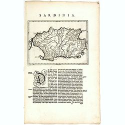
Sardinia Insula.
FIRST EDITION, FIRST ISSUE OF THIS MAP. Map of the Italian island of Sardinia in a copper engraving on a sheet with letterpress with German text description of the island...
Place & Date: Amsterdam, 1634
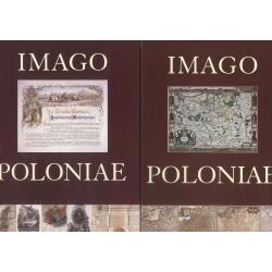
Imago Poloniae. Das Polnisch-Litauische Reich in Karten, Dokumenten und alten Drucken in der Sammlung von Tomasz Niewodniczanski. (2 volumes)
Catalog of an exhibition held Apr. 18-June 8, 2002 at the Staatsbibliothek zu Berlin--Preussischer Kulturbesitz, Berlin, Nov. 4-Dec. 31, 2002 at the Zamek Krótewski, War...
Place & Date: Warschau, Agenja Reklamowo-Wydawnicza Arkadiusz Grzegorczyk, 2002
Leaf on vellum from an antiphonary.
A more than 600 years old antiphonary leaf, written in Besancon, in 1370. Musical notation on 4 bars, the staves are in red and the notes in black: numerous pen-flourishe...
Place & Date: France, 1370
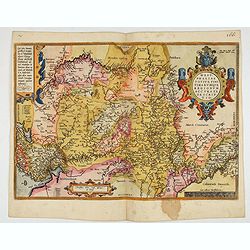
Westphaliae Totius, Finitimarumque Regionum Accurata Descriptio.
A very beautiful hand colored copper engraved map of North Rhein-Westphalia by A. Ortelius. This is a general map of Westphalia and the surrounding regions in northwest G...
Place & Date: Antwerp, ca 1584

Karte der Ukraina.
A large political, economical and transportation map of Ukraine, printed three months after the beginning of the WW II in Ukraine. Shows the newest borders, streets and r...
Place & Date: Vienna: Freytag u. Bernd u. Artaria August 1941
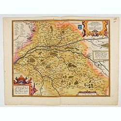
Touraine. Turonensis Ducatus.
Map of Touraine Duché in very fine original colours.
Place & Date: Antwerp, 1598
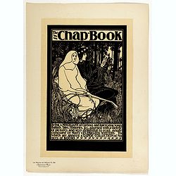
The Chap Book.
Chromo lithographed poster, "The Chap Book.", by BRADLEY, W. Plate 136, published in Maître 17, on April 1895. The "Les Maîtres de l'Affiche" contai...
Place & Date: Paris, Imprimerie Chaix, April 1895
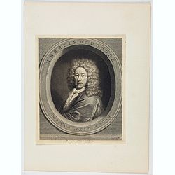
Mr. Romein De Hooghe.
Portrait of Romein De Hooghe, engraved by Jacobus Houbraken. De Hooghe is known as an engraver, draftsman, painter, sculptor and medalist. He is best known for his politi...
Place & Date: Amsterdam, 1733
![[Title page for] Partie des Forces de l'Europe. . .](/uploads/cache/47943-250x250.jpg)
[Title page for] Partie des Forces de l'Europe. . .
Very decorative title page from the rare Amsterdam edition of 1693 by Pieter Mortier (1661-1711) of de Fer's important work.Nicolas de Fer (1646-1720) was a cartographer,...
Place & Date: Amsterdam, 1693
![[Title page for] Galliae tabule geographicae . . .](/uploads/cache/47941-250x250.jpg)
[Title page for] Galliae tabule geographicae . . .
Very fine title page by Gerard Mercator, composed of an elaborate strapwork design with the portrait of a King at the top.
Place & Date: Amsterdam, 1613

Panache la nouvelle revue du Lido.
Very decorative poster designed by René Gruau for the Lido and its review Panache on the Champs Elysées, Paris. The bluebells are pictured for the 1985 show. René Grua...
Place & Date: Paris, ca. 1980
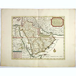
Nieuwe kaart van Arabia.
An attractive map of the Arabian Peninsula here called Gelukkig Arabia or Happy Arabia . The map has a great advance on other maps of the time by showing the true extent ...
Place & Date: Amsterdam, 1740
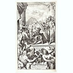
![[Title page for ] Atlas Novus Terrarum orbis Imperia.](/uploads/cache/47938-250x250.jpg)
[Title page for ] Atlas Novus Terrarum orbis Imperia.
Title page from Atlas Novus printed by Johann Ernst Udelbulner. Large elaborately engraved sheet with numerous allegorical figures. A large globe, showing the Eastern Hem...
Place & Date: Nuremberg, 1732
Nova et integra caenomaniae descriptio vulg. Le Mans.
Fine separately issued example of Gerard De Jode's map of Caenomaniae (Maine Province), from his Speculum Orbis Terrarum. Gérard de Jode (1508? -1590) published in Antwe...
Place & Date: Antwerp, ca. 1593
Plan general des chateaux et ville de St Germain en Laye.
City plan of St Germain en Laye, from Nicolas de Fer's "L'Atlas curieux ou le Monde réprésente dans des cartes. "The "Atlas Curieux" is a geographic...
Place & Date: Paris, 1705
![[Title page] Geographiae libri octo Graeco-Latini . . .](/uploads/cache/47936-250x250.jpg)
[Title page] Geographiae libri octo Graeco-Latini . . .
Fine decorative titlepage from the 1605 edition of Ptolemy. The plate is adorned with allegorical figures, fruits and architectural motifs. This 1605 edition was based on...
Place & Date: Amsterdam, 1605
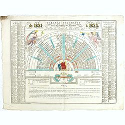
Tableau figuratif de la Chambre de Députés . . .
Figurative table of the Chamber of Deputies for the session of 1821. Showing as accurately as possible the place usually occupied by each of its members.
Place & Date: Paris, ca. 1821
Plan de la belle et magnifique Maison de Monsieur A St Cloud . . .
Plan of the city of Saint Cloud, from Nicolas de Fer's "L'Atlas curieux ou le Monde réprésente dans des cartes. "The "Atlas Curieux" is a geographic...
Place & Date: Paris, 1705
![[Title page] De Praecipuis, Totius Universi Urbibus, Liber Secundus.](/uploads/cache/47934-250x250.jpg)
[Title page] De Praecipuis, Totius Universi Urbibus, Liber Secundus.
Allegorical title page, from Volume 2 of Braun & Hogenberg's Civitatus Orbis Terrarum.At the top are figures representing Religion and Politics, placed on either side...
Place & Date: Cologne, 1582
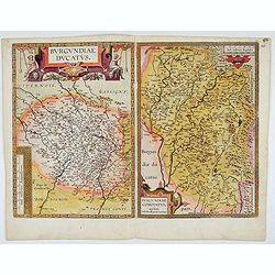
Burgundiae Ducatus. Burgundiae Comitatus.
Separately issued map of Burgundy area. Two maps of Burgundy region on a plate. Separately published map, without text on the verso. Second state with the date 1597 remov...
Place & Date: Antwerp, after 1612
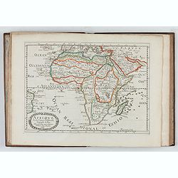
L'Affrique En Plusieurs Cartes Nouvelles, et exactes, &c.
Edition illustrated with 18 maps in original outline colors dated 1656. No date and title page and maps not numbered (according to Pastoureau 1 C, maps are numbered).Nico...
Place & Date: Paris, l'Auteur, after 1662
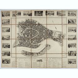
Pianta Topografica della R.a Città di Venezia con XIX de suoi principali prospetti.
A detailed town plan of Venice with an extensive key underneath and nineteen views of the important buildings among which : Piazza di S. Marco, Canal Grande, Tempio della...
Place & Date: Milan: Santo Vallardi, c.1840
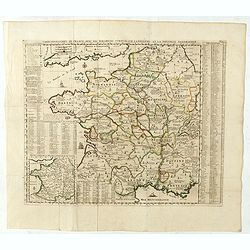
Carte Geographique du Royaume de France, avec des remarques curieuses sur l'ancienne, et la nouvelle geographie.
Map of France with a key table to the towns on both sides.Zacharie Chatelain (d.1723) was the father of Henri Abraham (1684-1743) and Zacharie Junior (1690-1754).They wor...
Place & Date: Amsterdam, ca. 1720
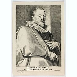
Theodorus Galle, Calcographus Anterpiæ.
Portrait of Theodorus Galle engraved by Lucas Vorsterman. Lucas Vorsterman was a Baroque engraver. He worked with the artists Peter Paul Rubens and Anthony van Dyck, as w...
Place & Date: Antwerp, ca. 1645

Beautemps-Beaupré (Charles-François).
Portrait of Charles-François Beautemps-Beaupré, engraved by Boilly.Charles-François Beautemps-Beaupré (6 August 1766 in La Neuville-au-Pont – 16 March 1854 in Paris...
Place & Date: Paris, 1822
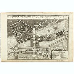
Plan general de Chantilly . . .
Plan of the city of Chantilly, from Nicolas de Fer's "L'Atlas curieux ou le Monde réprésente dans des cartes. "The "Atlas Curieux" is a geographic e...
Place & Date: Paris, 1705
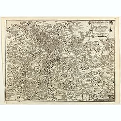
Le Païs Messin, ses dependances, et Terre Adiacentes.
Map of the Messin region, from Nicolas de Fer's "L'Atlas curieux ou le Monde réprésente dans des cartes. "The "Atlas Curieux" is a geographic encycl...
Place & Date: Paris, 1705
![[Title page] AtlasGeneral Méthodique et Elémentaire . . .](/uploads/cache/48054-250x250.jpg)
[Title page] AtlasGeneral Méthodique et Elémentaire . . .
Title page from Atlas general Méthodique et Elémentaire. Very fine, typical French title page, published with Desnos.
Place & Date: Paris, 1800
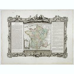
La France Divisée en ses quarante gouvernemens . . .
Map of France surrounded by a decorative frame.
Place & Date: Paris, 1770
![[Title page from ] Le Theatre du Monde ou le nouvel atlas mis en lumière par Guillaume et Jean Blaeu. Troisieme partie.](/uploads/cache/47942-250x250.jpg)
[Title page from ] Le Theatre du Monde ou le nouvel atlas mis en lumière par Guillaume et Jean Blaeu. Troisieme partie.
Frontispiece of " Le Theatre du Monde ou le nouvel atlas mis en lumière par Guillaume et Jean Blaeu. Troisieme partie." Very clear print with nice cartouches a...
Place & Date: Amsterdam, 1640
Isola del Re Nel Mare di Guascogna . . .
A beautiful map showing Ile de Ré in Bretagne, located in the Bay of Biscay off the coast of France, from Vincenzo Coronelli's Corso Geografico Universale.Italian text o...
Place & Date: Venice, 1690
![[Title page] Atlas Universel. . .](/uploads/cache/48053-250x250.jpg)
[Title page] Atlas Universel. . .
Beautiful title-frontispiece from the famous universal atlas initiated by geographers Gilles Robert and his son Didier Robert de Vaugondy, revised, corrected and enhanced...
Place & Date: Paris, 1806
![[Title page] Atlas François contenant les Cartes Géographiques dans lesquelles sont très exactement remarquez les Empires, Monarchies, Royaumes et Estats de l'Europe, de l'Asie; de l'Afrique et de l'Amérique.](/uploads/cache/48052-250x250.jpg)
[Title page] Atlas François contenant les Cartes Géographiques dans lesquelles sont très exactement remarquez les Empires, Monarchies, Royaumes et Estats de l'Europe, de l'Asie; de l'Afrique et de l'Amérique.
Decorative title page with a certain holding the title : Atlas François contenant les cartes géographiques . . . les Empires, Monarchies, Royaumes et Estats de l'Europe...
Place & Date: Paris, 1695
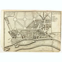
Plan d'un marais salant . . .
Aerial view of a salt marsh, with depiction of working scenes and a nice cartouche, from Nicolas de Fer's "L'Atlas curieux ou le Monde réprésente dans des cartes. ...
Place & Date: Paris, 1705
Gouvernement general de Languedoc . . .
Map of the Languedoc region, from Nicolas de Fer's "L'Atlas curieux ou le Monde réprésente dans des cartes. "The "Atlas Curieux" is a geographic enc...
Place & Date: Paris, 1705
Souveraineté de Neuchatel et de Vallangin.
Map of the Neuchatel region, from Nicolas de Fer's "L'Atlas curieux ou le Monde réprésente dans des cartes. "The "Atlas Curieux" is a geographic enc...
Place & Date: Paris, 1705
![[Title page] Le Neptune Francois. Quo ego. Sed moto praestat componere fluctus.](/uploads/cache/48058-250x250.jpg)
[Title page] Le Neptune Francois. Quo ego. Sed moto praestat componere fluctus.
Restrike of the title page featuring Neptune in a sea-chariot drawn by white horses, fleets of ships and allegorical figures of winged gods, all within an ornate border. ...
Place & Date: Paris, 1798 but ca. 1920
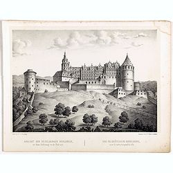
Ansicht der Heidelberger Schlosses. . .
Early lithograph published by Louis Charles François de Graimberg-Belleau. Lithographed by C.F Müller.French artist. Son of Gilles-François Belleau Graimberg. Louis Ch...
Place & Date: Graimberg, Heidelberg, ca. 1840
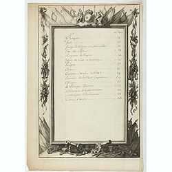
Table.
Index table page recto and verso of a world atlas.
Place & Date: Paris, 1700
![[Title page] Le Nouveau Theatre du Monde Nouvel Atlas Tome Troisieme.](/uploads/cache/47946-250x250.jpg)
[Title page] Le Nouveau Theatre du Monde Nouvel Atlas Tome Troisieme.
A very attractive title page from Le Nouveau Theatre du Monde Nouvel Atlas Tome Troisieme. .
Place & Date: Amsterdam, 1641
Atlas Novus ad Usum Serenissimi Burgundiae Ducis.
Title page of the homonymous atlas by Jean Covens and Corneille Mortier. Blank verso. Soldiers, savages and other individuals are shown approaching a queen seated on her ...
Place & Date: Amsterdam, 1730
![[Title page] Theatre Geographique du Royaume de France. . . .](/uploads/cache/48050-250x250.jpg)
[Title page] Theatre Geographique du Royaume de France. . . .
Title page by Nicolas de Clerc of ' Theatre Geographique du Royaume de France ". Joined page of " Table de toutes les cartes des provinces contenues", with...
Place & Date: Paris, 1619
Les Provinces, ou Gouvernement de Poictou, d'Anjou, du Maine, De Touraine . . .
Map centered on Loire region, with Blois, Saumur, Sancerre and Orleans, from Nicolas de Fer's "L'Atlas curieux ou le Monde réprésente dans des cartes. "The &q...
Place & Date: Paris, 1705
![[Title page] Le Nouveau & Grand Illuminant Flambeau de la Mer. La troisième partie. …Par Nicolas Jans Vooght.](/uploads/cache/47950-250x250.jpg)
[Title page] Le Nouveau & Grand Illuminant Flambeau de la Mer. La troisième partie. …Par Nicolas Jans Vooght.
Allegoric frontispiece of the third edition of the "Zee-Fakkel" with French text. The "4" from the date 16"89" is in manuscript.
Place & Date: Amsterdam, 1689
![[Title page] Le Nouveau Theatre du Monde.](/uploads/cache/47951-250x250.jpg)
[Title page] Le Nouveau Theatre du Monde.
The fine engraved frontispiece by F. Bleiswyk entitled "Le Nouveau Theatre du Monde" for Pieter van der AA. Shows Atlas carrying the world on his shoulders acco...
Place & Date: Leiden, 1713
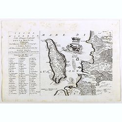
Isola d'Oleron, nella piaggie occidentali della Francia.
A beautiful and rare map showing île d'Oleron.The remarkable Vincenzo Coronelli (1650-1718), encyclopaedist, geographer, inventor and Doctor of Theology, was citizen of ...
Place & Date: Venice, 1690
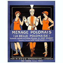
Ménage Polonais (La belle Polonaise) - Vaudeville opérette en 3 actes. Musique de Jean Gilbert.
Original advertising poster for the operetta " Ménage Polonais ". Title translation " Polish household " Ménage Polonais (The beautiful Polish) - Va...
Place & Date: Paris, 1914
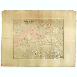
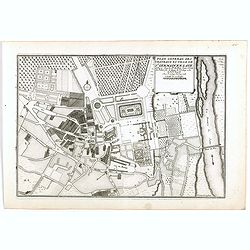
Quartier de Tivoli Nouveaux pereements de Rues.
Plan of the center of Paris showing Tivoli district with Madalene and Clichy. Lithography and pen and ink. Drawn in are the planned workshop of Serrurerie Théophile Mign...
Place & Date: Paris, ca.1835
![[Title page] Cartes particulières des costes de France de la mer mediterrannée . . .](/uploads/cache/48048-250x250.jpg)
[Title page] Cartes particulières des costes de France de la mer mediterrannée . . .
Title page by Tassin for the atlas " Cartes particulières des costes de France de la mer mediterrannée. . .".
Place & Date: Paris, 1633
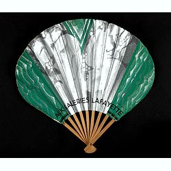
Le prestige des Galeries Lafayette rayonne sur le monde entier.
Decorative fan for Galeries Lafayette department store in Paris. Recto and verso illustrations. Printed by Georges Lang Paris.Read more about folding fans. [+]
Place & Date: Paris, ca. 1930

Carte générale de l' Amérique divisée en ses principaux états . . .
Map of North and South America. By C. F. Delamarche, successor of Robert de Vaugondy, Geographer. Descriptive text to the left.
Place & Date: Paris, 1820
![[Title page] Provincia di Bertagna.](/uploads/cache/48043-250x250.jpg)
[Title page] Provincia di Bertagna.
Title page by N.Tassin.
Place & Date: Paris, 1643
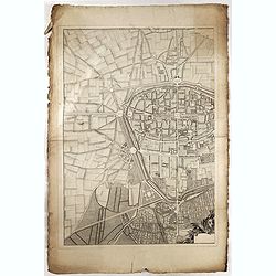
(Rheims)
Finely engraved plan of Rheims.
Place & Date: ca. 1750
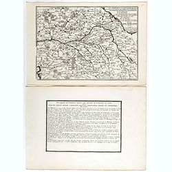
Picardiae Belgicae regionis descriptio
From Theatrum Orbis Terrarum [Atlas of the Whole World]. Prepared by Jean Surhon.Dare to go in Black. All early maps were printed in black and white, and many were kept t...
Place & Date: Antwerp, 1590
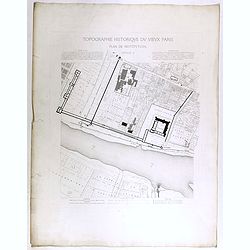
Topographie historique du vieux Paris / Plan de restitution Feuille V.
Copper engraved plan centered on Louvre by Jean-Joseph Sulpis (1826–1911) after a model by Adolphe Berty. Plate 5 from "Topographie historique du vieux Paris"...
Place & Date: Paris, 1866-1897

Artois. Atrebatum Regionis Vera Descripto.
Prepared by Jacob Surhon, who made a manuscript map of Artois for which he received 36 Livres from Charles V in 1554. For security reasons, the map was not published. Onl...
Place & Date: Antwerp, 1598
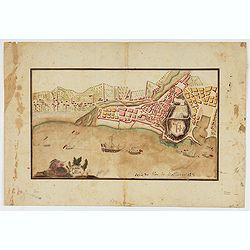
Piano di Nizza.
Rare 1797 manuscript map of Nice, with the French navy attacking from the sea. Unknown author, Italian, but map attributed to an original, probably broadsheet map by Moll...
Place & Date: Italy, after 1797
![[Title page] Figura di tutta la francia.](/uploads/cache/48046-250x250.jpg)
[Title page] Figura di tutta la francia.
Title page by Tassin.
Place & Date: Paris, 1643
![[Title page] Figura Universale](/uploads/cache/48045-250x250.jpg)
[Title page] Figura Universale
Title page by N.Tassin.
Place & Date: Paris, 1643