Browse Listings in Australia & Oceania > Pacific
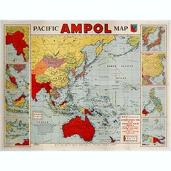
Pacific AMPOL Map
A large and very colorful World War II era map of the Pacific Ocean produced with the complements of the Australian Motorists Petrol Co. Ltd. The map itself shows the Pac...
- $1000 / ≈ €936
Place & Date: Australia, ca 1942
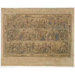
Tableau des Decouvertes du Cap.ne Cook, & de la Pérouse.
Three series of figures of natives with key below, surrounded by narrow pictorial border.Grasset de Saint Sauveur skillfully wove together two dozen individual scenes fro...
- $2200 / ≈ €2059
Place & Date: Paris, 1798

Océanie.
A very decorative 19th century map of the Pacific Ocean, with hand colored lines indicating the extent of Polynesia, Mirconesia, Melanesia, and Malaysia (or Southeast Asi...
Place & Date: Paris, 1850
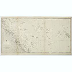
Australia, Coral Sea and Great Barrier Reefs shewing the inner and outer routes to Torres Strait. Sheet 1. . .
Large scale chart representing the Great Barrier Reef and the Coral Sea showing routes to the Torres Strait. Sheet 1.First published at the Admiralty 1860 with new editio...
- $150 / ≈ €140
Place & Date: London, 1869-1943
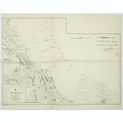
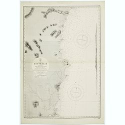
Sheet XI East coast of Australia - Sandy Cape to Keppel isles surveyed by Staff Commr. E.P. Bedwell, Navg. Lieutt. E.H.S. Bray, and Navg. Sub. Lieutt. E.R. Connor, 1870
Large chart representing East coast of Australia from Sandy Cape to Keppel isles surveyed by Staff Commr. E.P. Bedwell. With two inset charts of Pancake Creek. Scale 1:24...
- $150 / ≈ €140
Place & Date: London, 1883-1944
![[Lot of Five Pacific Brand crate labels]](/uploads/cache/45706-250x250.jpg)
[Lot of Five Pacific Brand crate labels]
Five fruit crate label for Pacific Brand, showing a lemon and a map of the Pacific Ocean, centered on Hawaii and including a part of California and Asia, with also Austra...
Place & Date: Santa Barbara, 1917
![Australia, E. coast - Queensland Percy isles to Whitsunday I. chiefly from a joint Admiralty & Colonial survey by Staff Commander Bedwell, R.N. 1873 to 1879 [1945]](/uploads/cache/36212-250x250.jpg)
Australia, E. coast - Queensland Percy isles to Whitsunday I. chiefly from a joint Admiralty & Colonial survey by Staff Commander Bedwell, R.N. 1873 to 1879 [1945]
Large chart representing East coast of Australia with Queensland from Percy isles to Whitsunday Island, with inset of Beverley Islands Anchorage. Scale 1:74,000. in lower...
- $150 / ≈ €140
Place & Date: London, 1882-1945
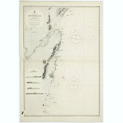
East coast of Australia. New South Wales. Sheet VII, Coffs Islands to Evans Head surveyed by Comr. Fredk. W. Sidney R.N. assisted by E.P. Bedwell & J.T. Gowlland, Masters & S. Guy, 2nd Master R.N. 1864-5
Large chart representing East coast of Australia with New South Wales including Coffs Islands to Evans Head surveyed by Comr. Fredk. W. Sidney R.N. First published at the...
- $150 / ≈ €140
Place & Date: London, 1907-1943
Sheet VI East coast of Australia. New South Wales Tacking Point to Coffs Islands surveyed by Comr. Fredk. W. Sidney R.N. . . 1862 - 1864. . .
Large chart representing East coast of Australia with New South Wales including Tacking Point to Coffs Islands surveyed by Comr. Fredk. W. Sidney R.N. from 1862 - 1864. F...
- $150 / ≈ €140
Place & Date: London, 1939-1942
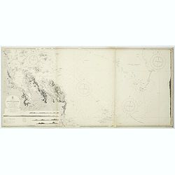
Sheet XII East coast of Australia Queensland Keppel Isles to Percy Isles. . .
Large chart representing east coast of Australia's Queensland showing Keppel Isles to Percy Isles with relief shown by hachures, spot heights and bathymetric soundings. S...
- $150 / ≈ €140
Place & Date: London, 1932-1944