Browse Listings in Atlases
Introductio in universam geographiam tam veterem, quám novam... et tabulis geographicis aucta studio & operâ Johannis Bunonis. . .
Engraved title with minor ink dash, title with former owner's signatures Joannes Steuchig, (could be the Swedish archbishop Johannes Steuchius (1676-1742). D. Hildebrand ...
- $3000 / ≈ €2807
Place & Date: Amsterdam, 1676
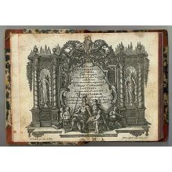
Atlas Geographicus portatilis XXIX mappis orbis habitabilis
Fine pocket atlas containing a world and celestial map, further maps of the four continents and of European countries. The map of America has a blank coastline north to C...
- $2750 / ≈ €2573
Place & Date: Augsburg 1762
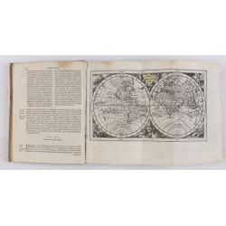
Almanach géographique ou petit atlas élémentaire composé de Cartes générales et particulières des différens Empires, Royaumes et Républiques de l'Europe. . .
Charming almanac with two engraved dedication and title page, portrait of Christian VII. Roy de Dannemarck et de Norvège.The map of Asia is of interest for the use of Ko...
- $3000 / ≈ €2807
Place & Date: Paris, 1770
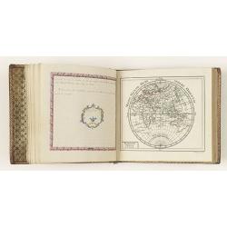
Etrennes interessantes des quartre parties du monde..
A charming almanac for the year 1778. The maps are engraved by Durand et Le Roy, and each map has the name of the author Giovanni Antonio Battista Rizzi-Zannoni. This cha...
- $2500 / ≈ €2339
Place & Date: Paris, 1760
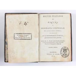
Breves tratados de esfera y geografía universal, con algunas noticias históricas, en especial en lo perteneciente a España, para instruccion de la juventud.
Third edition of this popular Spanish Atlas for children, illustrated with 6 folding engraved "blind" maps, all finely colored by hand, in the main part in orig...
- $750 / ≈ €702
Place & Date: Madrid, Impreta de Collado, 1814
![[12 volumes] Recueil des voyages qui ont servi à l'établissement et aux progrez de la Compagnie des Indes Orientales, forméedans les Provinces-Unies des Païs-Bas...](/uploads/cache/43700-250x250.jpg)
[12 volumes] Recueil des voyages qui ont servi à l'établissement et aux progrez de la Compagnie des Indes Orientales, forméedans les Provinces-Unies des Païs-Bas...
An important richly illustrated compendium of the first Dutch voyages to East India, of great interest for the history and establisment of the Dutch global trade, particu...
- $5000 / ≈ €4679
Place & Date: Rouen, Pierre Le Boucher, 1725
![[Atlas] Images du Monde. Atlas Illustré.](/uploads/cache/44610-250x250.jpg)
[Atlas] Images du Monde. Atlas Illustré.
In original green publishers green covered cloth covers, complete with a contents table and 33 pictorial maps of countries of the world (including continents and a world ...
- $200 / ≈ €187
Place & Date: Paris, 1942
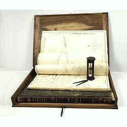
J.Horsburgh/ R.H.Bate / G.H.Stapleton. The two chart books are bound in contemp. half calf, and include together 57 of the most up-to-date French (Depot général de la marine) and English (Hydrographic Office) charts available in 1847 for sailing t
BOOK 1 : Mainly charts by "Dépôt Général de la Marine" including 20 folding charts. The binding measuring 665x275mm, the charts mostly 595x910mm.1. Dépôt ...
- $50000 / ≈ €46786
Place & Date: Paris, London, Hong Kong, 1835 - 1849
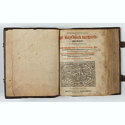
Itinerarium Sacrae Scripturae, dat is, Het Reysboeck der heyligher Schrift
This is a scarce 1648 Dutch edition of Büntings "Itinerarium Sacrae Scripturae" printed in Leeuwarden. The book includes 6 folding maps and 2 plates. The book ...
- $3000 / ≈ €2807
Place & Date: Leeuwarden, de Vries, Jan Jansz., 1648
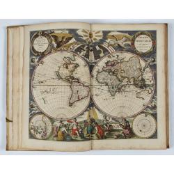
L’Atlas de la Mer ou Monde aquaticque.
Original blind-stamped vellum binding ; attractive ORIGINAL HAND-COLOR in outline with cartouches, windroses and decoration in full orginal color ; internally some usual ...
- $75000 / ≈ €70179
Place & Date: Amsterdam, sur le Cay de Teexel, prez du Rams-Koy, au miroir de la Mer, 1670