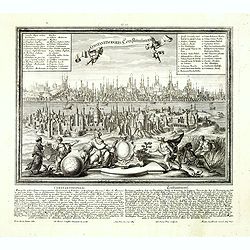
Constantinopolis Constantinopel.
Very rare and decorative panoramic view of Istanbul prepared by Friedrich Berhard Werner and published by Martin Engelbrecht. The engraving is done by Johann Georg Ringli...
- $3500 / ≈ €3275
Place & Date: Augsburg, M.Engelbrecht, ca.1730-1740

(Untitled view from Scutari with a view of Constantinople)
Panoramic view from Scutari with a view of Constantinople in the distance, after a design by Johann Schranz. Published by J. Missiriè.
Place & Date: Paris, 1860
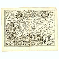
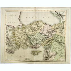
Natoliae Sive Asia Minor.
From the first edition. Map of Turkey, also depicting Cyprus.
- $350 / ≈ €328
Place & Date: Amsterdam, 1606

A Map of the Environs of Constantinople Drawn from a great number of accurate astronomical & geographical manuscripts and printed documents, by A. Arrowsmith 1801 and 1804.
Arrowsmith’s large and detailed map of the Ottoman Empire and the Black Sea, with Cyprus, Crete and the Greek Islands in the Mediterranean Sea, Albania, Bosnia and Herz...
Place & Date: London, No.10 Soho Square, 4th September 1804
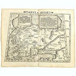
Tabula Asiae I (Turkey)
The first edition of Munster's map of Turkey, based upon Claudius Ptolemy which appeared in his "Geographia Universalis", first published in 1540. The Geographi...
- $500 / ≈ €468
Place & Date: Basel, Heinrich Petri, 1545
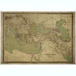
Carte général de L'Empire Ottoman en Europe et en Asie. . . dressée par Henri Kiepert.
Large School wall map of Turkish Empire printed in chromo-lithography. Published by Dieter Reimer and printed by Ferdind Barth in Berlin.This rare map has two insets in l...
- $700 / ≈ €655
Place & Date: Berlin, Dieter Reimer, 1867
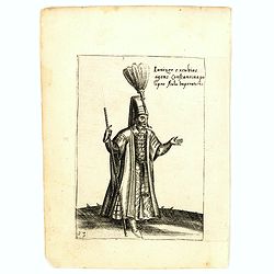
Ianizer excubias agens constantinapo lipro Aulu Imperatoris.
Costume plate published by Pietro Bertelli in his "Diversarum nationum habitus", a sixteenth-century Italian costume book. The work was published with fold-out ...
- $60 / ≈ €56
Place & Date: Padua, 1589
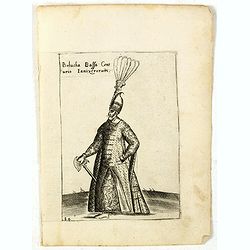
Bolucha Bassa Centurio Ianizerorum.
Costume plate published by Pietro Bertelli in his "Diversarum nationum habitus", a sixteenth-century Italian costume book. The work was published with fold-out ...
- $60 / ≈ €56
Place & Date: Padua, 1589
![[Asia Minor]](/uploads/cache/35958-250x250.jpg)
[Asia Minor]
Early, attractive woodcut map of Turkey, with Cyprus shown in the lower right corner. On the full sheet with German text beneath and verso. From the German edition of Seb...
- $50 / ≈ €47
Place & Date: Basle, 1584
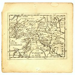
Turkey in Asia.
An attractive map covering Asia Minor, Syria, Armenia, Georgia, Kurdistan, Iraq, Syria, Cyprus and the Black Sea. Shows towns, rivers, mountains, lakes, etc. In pretty or...
- $65 / ≈ €61
Place & Date: London, 1794
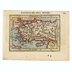
Natolia olim Asia Minor.
Genuine antique map "Natolia" by Abraham Ortelius from Epitome Theatri Orbis Terrarum, published in Antwerp in 1609. This charming 400-year-old miniature copper...
- $200 / ≈ €187
Place & Date: Antwerp, 1609
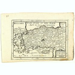
Die Asiatische Turkey begreift in sich Natolien, Georgien, Armenien, Mesopotamien Syrien, und Arabien. . .
Map of Turkey bordered by the Black Sea to the north, Syria and Sinai Peninsula to the south, Turkey in Europe to the west, with a small title cartouche. Explanatory text...
- $200 / ≈ €187
Place & Date: Augsburg, 1789
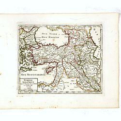
La Turquie en Asie.
Uncommon miniature map of Turkey, Cyprus, Palestine, Iran, Iraq. From Pierre Duval's "La Geographie Universeille" dated 1676. Following his "Cartes de geog...
- $100 / ≈ €94
Place & Date: Paris,1676
![[Asia Minor]](/uploads/cache/35969-250x250.jpg)
[Asia Minor]
Sebastien Münster's small map of Asia Minor, complete with a sea monster, bold rivers, mountains, forests and prominent cities of the region. German text below and to ve...
- $75 / ≈ €70
Place & Date: Basle, 1588
Die Asiatische Turkey 1854.
Steel engraved map, hand colored in outline when it was published. The detailed map shows the Asian part of Turkey, most of Syria, Iraq, Cyprus and the southern reaches o...
- $70 / ≈ €66
Place & Date: Hildburghausen, Bibliograph Institut,1854
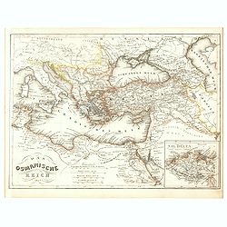
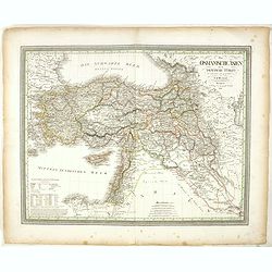
Das Osmanische Reich 1854.
From Meyer's Neuester Zeitungs Atlas. The map is well engraved in the German style with plenty of detail but minimal decoration. Inset map of the Nile Delta.
- $40 / ≈ €37
Place & Date: Heidelberg, 1854
Modern Asia Minor. Drawn & Engraved for Dr. Playfair's Geography.
Detailed map of Black Sea, Cyprus and Turkey engraved by Samuel John Neele (1758-1824) and published by Alexander Macredie. Originally engraved for James Playfair's "...
- $175 / ≈ €164
Place & Date: London / Edinburgh, 1824
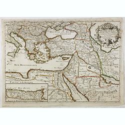
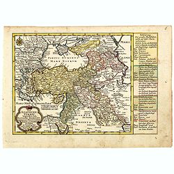
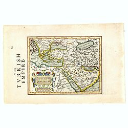
L'Empire des Turcs en Europe, en Asie et en Afrique.
A nice map showing the Turkish Empire, including an inset map of kingdom of Alger. Extending from Italy and the Eastern Mediterranean in the west to the Caspian Sea and P...
- $550 / ≈ €515
Place & Date: Paris, 1686
![Femme de la Carie [together with] Pretre Indous.](/uploads/cache/36926-250x250.jpg)
Femme de la Carie [together with] Pretre Indous.
Set of two originally hand-colored mezzotints of a woman from the region of Bodrum in Turkey and an Hindu Priest engraved by Félix Mixelle and Lachaussée Jeune after Ja...
- $50 / ≈ €47
Place & Date: Paris,1801-1806
Das Osmanische asien oder die Asiatische Türkey. . .
Decorative map showing 'Asia Minor' with its neighboring countries. Prepared by Karl Ferdinand Weiland The eastern part of the Mediterranean Sea with Cyprus is as well sh...
- $200 / ≈ €187
Place & Date: Weimar, 1836-1838
Carte physique et politique de la Turquie d'Europe et d'Asie contenant la Syrie, une partie de l'Egypte . . .
A detailed map including Turkey, Greece, Black Sea, Holy Land, Georgie, Iran, Iraq, Armenia.
Place & Date: Brussels, 1840
Turcicum Imperium.
Early map of Turkey, the Arabian peninsula and eastern part of the Mediterranean.From the English edition of Mercator's Atlas Minor. This edition 1635. English text on ve...
- $400 / ≈ €374
Place & Date: Amsterdam, 1635
Turquie Asiatique. Par le Sr. Robert Geog. Ord du Roi avec Privilege 1748.
Small detailed map of Turkey. From Atlas Portatif Universel, by Robert de Vaugondy.Page 161 outside border top right. First and only state.
- $80 / ≈ €75
Place & Date: Paris, 1754
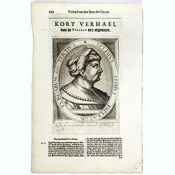
Selimus Primus Imperator Turcarum decimus Tertius.
The engraving depicts a half length oval portrait of Selim I, who was the Sultan of the Ottoman Empire from 1512 to 1520. His reign is notable for the enormous expansion ...
- $30 / ≈ €28
Place & Date: Amsterdam, Cloppenburch, 1621
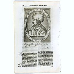
Solimannus Turcarum Imperator X. Ex Stirpe Ottomannicae.
The engraving depicts a half length oval portrait of "Solimannus Turcarum Imperator X", signed lower right corner N. de Cleck". Nicolaes de Clerck (de kler...
Place & Date: Amsterdam, Cloppenburch, 1621
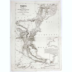
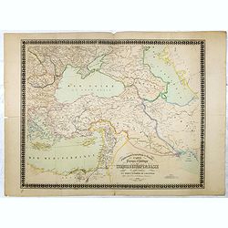
Karte der Hauptstraßen von der niederen Donau bis Constantinopel … / Spezialkarte des Meerbusens von Burgas . ..
Uncommon map of the routes of the eastern part of the Balkan Peninsula. prepared by C. Zirbeck The map has two insets "Meerbusen von Burgas oder Mesambri" (Bay ...
- $550 / ≈ €515
Place & Date: 1820
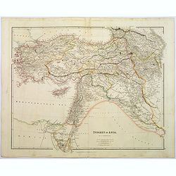
Turkey in Asia.
A lovely looking steel engraved map of Turkey in Asia. Map extent is Asia Minor, Syria, Holy Land, across to the Caucasian peoples that inhabit the lands between the Blac...
Place & Date: London, 1839
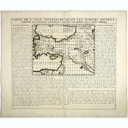
Carte De L'Asie Inferieure Selon Les Auteurs Anciens, Enrichie de Remarques Historiques sur les Changemens qui y sont arrivez.
Text page with inset map (220x269.mm.) of Turkey, including Cyprus from Chatelain's monumental 7 volume "Atlas Historique". Henri Abraham Chatelain (1684 – 17...
- $200 / ≈ €187
Place & Date: Amsterdam, 1720
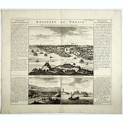
Bosphore de Thrace.
This handsome folio sheet present three views of the strategically important Bosporus. At top is a large decorative bird's-eye view of Istanbul as viewed from across the ...
Place & Date: Amsterdam, 1720
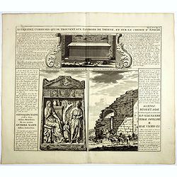
Antiquez curieuses qui se trouvent aux environs de Smyrne, et sur le chemin d'Ephese.
Folio sheet describing and depicting ancient Greek monuments and ruins in Smyrna (Izmir). From Chatelain's monumental 7 volume "Atlas Historique". Henri Abraham...
- $75 / ≈ €70
Place & Date: Amsterdam, 1720
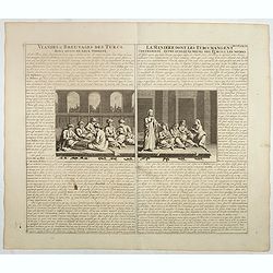
Viandes & breuvages des Turcs . . . / La manière dont les Turcs mangent . . .
Interesting sheet with a detailed views illustrating the lunch time in turkey, with descriptive French text, from Chatelain's monumental 7 volume Atlas Historique. In upp...
- $55 / ≈ €51
Place & Date: Amsterdam, ca. 1720
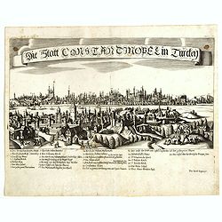
Constantinopolitanae urbis effigies ad vivum expressa.
Extremely rare panoramic view of Istanbul published by Jacob Koppmayr. With a numbered key (1-29) to principal places in town. Jacob Koppmayr was a printer and publisher ...
- $900 / ≈ €842
Place & Date: Augsburg, 1689
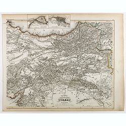
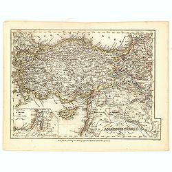
Specialkarte der Asiatischen Turkey : 1. Blatt Anadoli (Klein - Asien)
Steel engraved map of western part of Turkey, engraved by Ifslieb and J. Grassl.
- $75 / ≈ €70
Place & Date: Hildburghausen, 1860
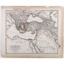
Das osmannische Reich und dessen Schutz-Staaten, nach seiner grossten Ausdehnung im XVIIten Jahrhundert.
Karl von Spruner's historical map of the Ottoman empire at the end of the 17th century. Showing Bosnia to Egypt and as far east as Persia. Including northern part of the ...
- $175 / ≈ €164
Place & Date: Gotha, J.Perthes, ca. 1854
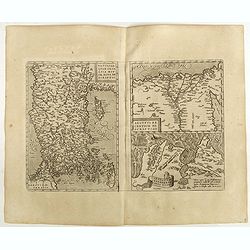
Natoliae Quae Olim Asia Minor, Nova de Scriptio / Carthaginis Celeberrimi Sinus Typus / Aegypti re Centior de Scriptio
Three detailed regional maps by Ortelius from his "Theatrum Orbis Terrarum", the world's first modern atlas.The first map covers Asia Minor, Cyprus and the East...
Place & Date: Antwerp, 1598
Natolie ou Asie mineur, Lieües d'Alemag.
Rare map of Turkey and Cyprus published by Jollain in 1667. Published in "Trésor Des Cartes Geographiques Des Principaux Estats de Lunivers".This atlas is base...
- $250 / ≈ €234
Place & Date: Paris, 1667
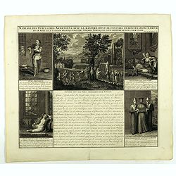
Mariage des Turcs & des Armeniens, avec la ma niere dont se font les demonstrations d'amour . . .
Showing the marriage rituals and lives of Turks and Armenians. Five engravings set round a text panel in French. From Chatelain's monumental 7 volume "Atlas Historiq...
- $150 / ≈ €140
Place & Date: Amsterdam, 1720
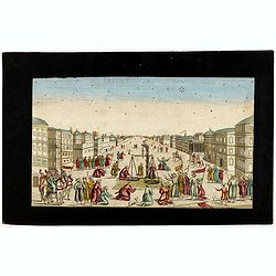
Imaginary view of a square with Muslims festival.
Imaginary view of a square with Muslims festival. A so called optical print.
- $200 / ≈ €187
Place & Date: Paris, ca. 1750

Anamu Buru to Latakia including Iskenderun Körfezi.
A highly corrected version of Admiralty chart 2632 originally published 25 November 1955 under the Superintendence of Captain K.SB. Collins. Edition Date 1984 Detailed ch...
- $100 / ≈ €94
Place & Date: London, 1955 - 1984
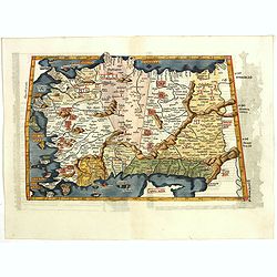
Tabula I Asiae.
Ptolemaic map of Turkey.From Lorenz Fries' edition of Ptolemy's Geographia, largely based on the 1513 map by Waldseemuller. "The elaborate Renaissance woodcut panels...
- $750 / ≈ €702
Place & Date: Vienna, 1490, 1535