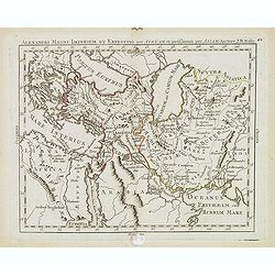
Alexandri magni imperium et expeditio per Africam. . .
Scarce map of Imperium of Alexandre the Great, centered on Turkey, Armenia, etc. prepared by Nolin and published by L.J. Mondhare for his Atlas Général a l'usage des co...
- $75 / ≈ €70
Place & Date: Paris, 1781
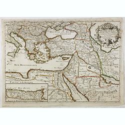
L'Empire des Turcs en Europe, en Asie et en Afrique.
A nice map showing the Turkish Empire, including an inset map of kingdom of Alger. Extending from Italy and the Eastern Mediterranean in the west to the Caspian Sea and P...
- $550 / ≈ €515
Place & Date: Paris, 1686
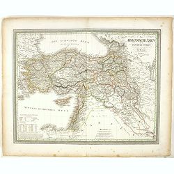
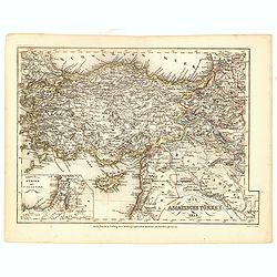
Das Osmanische asien oder die Asiatische Türkey. . .
Decorative map showing 'Asia Minor' with its neighboring countries. Prepared by Karl Ferdinand Weiland The eastern part of the Mediterranean Sea with Cyprus is as well sh...
- $200 / ≈ €187
Place & Date: Weimar, 1836-1838
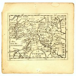
La Turquie en Asie.
Uncommon miniature map of Turkey, Cyprus, Palestine, Iran, Iraq. From Pierre Duval's "La Geographie Universeille" dated 1676. Following his "Cartes de geog...
- $100 / ≈ €94
Place & Date: Paris,1676
![[Asia Minor]](/uploads/cache/35969-250x250.jpg)
[Asia Minor]
Sebastien Münster's small map of Asia Minor, complete with a sea monster, bold rivers, mountains, forests and prominent cities of the region. German text below and to ve...
- $75 / ≈ €70
Place & Date: Basle, 1588
Die Asiatische Turkey 1854.
Steel engraved map, hand colored in outline when it was published. The detailed map shows the Asian part of Turkey, most of Syria, Iraq, Cyprus and the southern reaches o...
- $70 / ≈ €66
Place & Date: Hildburghausen, Bibliograph Institut,1854
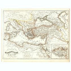
Das Osmanische Reich 1854.
From Meyer's Neuester Zeitungs Atlas. The map is well engraved in the German style with plenty of detail but minimal decoration. Inset map of the Nile Delta.
- $40 / ≈ €37
Place & Date: Heidelberg, 1854
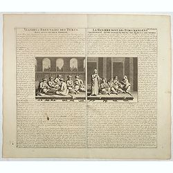
Viandes & breuvages des Turcs . . . / La manière dont les Turcs mangent . . .
Interesting sheet with a detailed views illustrating the lunch time in turkey, with descriptive French text, from Chatelain's monumental 7 volume Atlas Historique. In upp...
- $55 / ≈ €51
Place & Date: Amsterdam, ca. 1720
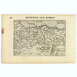
Natolia.
A miniature map of Turkish Natolia, published by Petrus Bertius in Amsterdam, at the beginning of the seventeenth century. This attractive small map features hatching in ...
- $150 / ≈ €140
Place & Date: Amsterdam, 1606
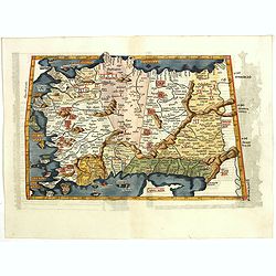
Tabula I Asiae.
Ptolemaic map of Turkey.From Lorenz Fries' edition of Ptolemy's Geographia, largely based on the 1513 map by Waldseemuller. "The elaborate Renaissance woodcut panels...
- $750 / ≈ €702
Place & Date: Vienna, 1490, 1535