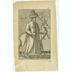
Religieux Turc. (26)
Sought-after copper engraved plate taken from Laonikos Chalcocondyle’s "L'histoire de la décadence de l'empire grec et establissement de celuy des Turcs." by...
Place & Date: Paris, Mathieu Guillemot, 1650
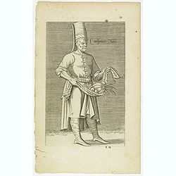
Cuisinier Turc. (19)
Sought-after copper engraved plate taken from Laonikos Chalcocondyle’s "L'histoire de la décadence de l'empire grec et establissement de celuy des Turcs." by...
Place & Date: Paris, Mathieu Guillemot, 1650
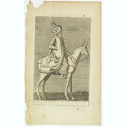
Calidesquer. (5)
Sought-after copper engraved plate from Laonikos Chalcocondyle’s "L'histoire de la décadence de l'empire grec et establissement de celuy des Turcs." by Thoma...
Place & Date: Paris, Mathieu Guillemot, 1650
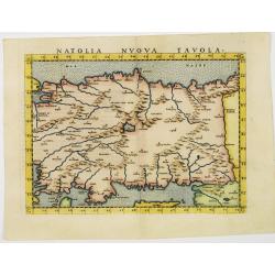
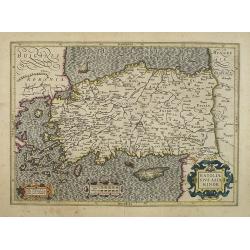
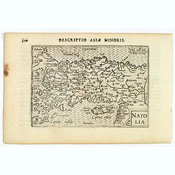
Natolia nuova tavola.
Uncommon first edition of this early map of Turkey.Girolamo Ruscelli's edition of Ptolemy's Geographia included newly engraved copperplates by Giulio and Livio Sanuto. Th...
- $375 / ≈ €351
Place & Date: Venice, 1561
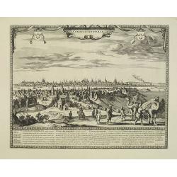
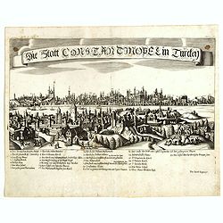
Constantinopolis.
Extremely rare panoramic town-view of Istanbul published by Frederick de Wit. With a numbered key (1-17) to principal places in town and a poem in Latin, Dutch, English a...
- $4000 / ≈ €3743
Place & Date: Amsterdam, 1680
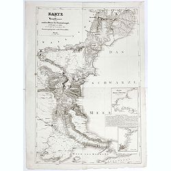
Karte der Hauptstraßen von der niederen Donau bis Constantinopel … / Spezialkarte des Meerbusens von Burgas . ..
Uncommon map of the routes of the eastern part of the Balkan Peninsula. prepared by C. Zirbeck The map has two insets "Meerbusen von Burgas oder Mesambri" (Bay ...
- $550 / ≈ €515
Place & Date: 1820
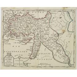
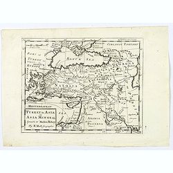
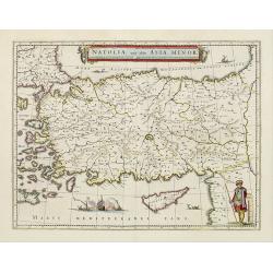
Natoliae Sive Asia Minor.
Map of Turkey, also depicting Cyprus.
- $750 / ≈ €702
Place & Date: Amsterdam, 1610
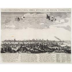
Constantinopolitanae urbis effigies ad vivum expressa.
Extremely rare panoramic view of Istanbul published by Rombout van den Hoeye. With a numbered key (1-29) to principal places in town and a Latin, Dutch, and French poem. ...
- $3500 / ≈ €3275
Place & Date: Amsterdam, 1650
Constantinopolis Constantinopel.
Very rare and decorative panoramic view of Istanbul prepared by Friedrich Berhard Werner and published by Martin Engelbrecht. The engraving is done by Johann Georg Ringli...
- $3500 / ≈ €3275
Place & Date: Augsburg, M.Engelbrecht, ca.1730-1740
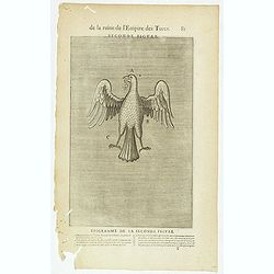
De la Ruine de l'Empire des Turcs Seconde figure / Epigramme de la Seconde figure. (81)
Sought-after copper engraved plate taken from Laonikos Chalcocondyle’s "L'histoire de la décadence de l'empire grec et establissement de celuy des Turcs", th...
- $50 / ≈ €47
Place & Date: Paris, Mathieu Guillemot, 1650
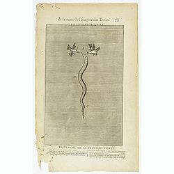
De la Ruine de l'Empire des Turcs Première figure / Epigramme de la première figure. (79)
Sought-after copper engraved plate taken from Laonikos Chalcocondyle’s "L'histoire de la décadence de l'empire grec et establissement de celuy des Turcs", th...
- $50 / ≈ €47
Place & Date: Paris, Mathieu Guillemot, 1650
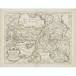
Turquie d'Asie . . .
Map of Turkey, including Cyprus, Palestine, etc. , from Atlas moderne portatif composé de vingt-huit cartes sur toutes les parties du globe terrestre .. A l'usage des Co...
- $100 / ≈ €94
Place & Date: Paris, Prudhomme, Levrault, Debray, 1806
![Constatinopolis. [Istanbul]](/uploads/cache/26996-250x250.jpg)
Constatinopolis. [Istanbul]
Panoramic town-view of Constantinople (Istanbul). Woodcut published in the so-called pirate edition of the "small Schedel" in Augsburg, 1497, Latin edition. Ori...
Place & Date: Augsburg, Johann Schönsperger, 1497
Selling price: $500
Sold in 2009
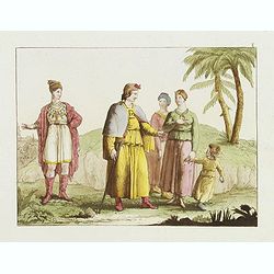
[Gyap, father of the young Teschou Lama
Aquatint print with Gyap, father of the young Teschou Lama "and his wife and the" portrait of the Grand Lama. - Tibet. Plate N° 8. From Giulio Ferrario's work ...
- $80 / ≈ €75
Place & Date: Milan, 1827
Turkey in Asia: or Asia Minor &c.
Herman Moll's map of the Turkish Empire in Asia, published in London during the first half of the eighteenth century. It shows the eastern Mediterranean, including Crete ...
- $150 / ≈ €140
Place & Date: London, ca 1729
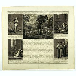
Mariage des Turcs & des Armeniens, avec la ma niere dont se font les demonstrations d'amour . . .
Showing the marriage rituals and lives of Turks and Armenians. Five engravings set round a text panel in French. From Chatelain's monumental 7 volume "Atlas Historiq...
- $150 / ≈ €140
Place & Date: Amsterdam, 1720
Natolie ou Asie mineur, Lieües d'Alemag.
Rare map of Turkey and Cyprus published by Jollain in 1667. Published in "Trésor Des Cartes Geographiques Des Principaux Estats de Lunivers".This atlas is base...
- $250 / ≈ €234
Place & Date: Paris, 1667
![[Map of Turkey]](/uploads/cache/31502-250x250.jpg)
[Map of Turkey]
Page with an early representation of Turkey with Cyprus and Syria. This text page with a fine wood block printed map is from the rare work "C. Iulii Solini Polyhisto...
- $275 / ≈ €257
Place & Date: Basle, Michael Isengrin, 1544
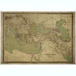
Carte général de L'Empire Ottoman en Europe et en Asie. . . dressée par Henri Kiepert.
Large School wall map of Turkish Empire printed in chromo-lithography. Published by Dieter Reimer and printed by Ferdind Barth in Berlin.This rare map has two insets in l...
- $700 / ≈ €655
Place & Date: Berlin, Dieter Reimer, 1867
Turquie Asiatique. . .
Scarce map of Turkey prepared by Nolin and published by L.J. Mondhare for his Atlas Général a l'usage des colleges et maisons d'education.. Louis Joseph Mondhare was ac...
- $100 / ≈ €94
Place & Date: Paris, 1783
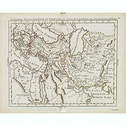
Alexandri magni imperium et expeditio per Africam. . .
Scarce map of Imperium of Alexandre the Great, centered on Turkey, Armenia, etc. prepared by Nolin and published by L.J. Mondhare for his Atlas Général a l'usage des co...
- $75 / ≈ €70
Place & Date: Paris, 1781
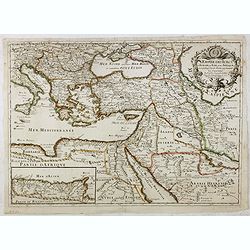
L'Empire des Turcs en Europe, en Asie et en Afrique.
A nice map showing the Turkish Empire, including an inset map of kingdom of Alger. Extending from Italy and the Eastern Mediterranean in the west to the Caspian Sea and P...
- $550 / ≈ €515
Place & Date: Paris, 1686
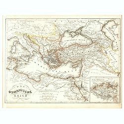
Das Osmanische asien oder die Asiatische Türkey. . .
Decorative map showing 'Asia Minor' with its neighboring countries. Prepared by Karl Ferdinand Weiland The eastern part of the Mediterranean Sea with Cyprus is as well sh...
- $200 / ≈ €187
Place & Date: Weimar, 1836-1838
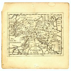
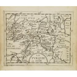
La Turquie en Asie.
Uncommon miniature map of Turkey, Cyprus, Palestine, Iran, Iraq. From Pierre Duval's "La Geographie Universeille" dated 1676. Following his "Cartes de geog...
- $100 / ≈ €94
Place & Date: Paris,1676
![[Asia Minor]](/uploads/cache/35969-250x250.jpg)
[Asia Minor]
Sebastien Münster's small map of Asia Minor, complete with a sea monster, bold rivers, mountains, forests and prominent cities of the region. German text below and to ve...
- $75 / ≈ €70
Place & Date: Basle, 1588
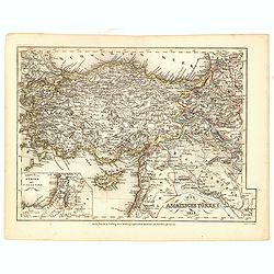
Die Asiatische Turkey 1854.
Steel engraved map, hand colored in outline when it was published. The detailed map shows the Asian part of Turkey, most of Syria, Iraq, Cyprus and the southern reaches o...
- $70 / ≈ €66
Place & Date: Hildburghausen, Bibliograph Institut,1854
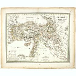
Das Osmanische Reich 1854.
From Meyer's Neuester Zeitungs Atlas. The map is well engraved in the German style with plenty of detail but minimal decoration. Inset map of the Nile Delta.
- $40 / ≈ €37
Place & Date: Heidelberg, 1854
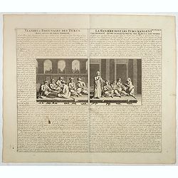
Viandes & breuvages des Turcs . . . / La manière dont les Turcs mangent . . .
Interesting sheet with a detailed views illustrating the lunch time in turkey, with descriptive French text, from Chatelain's monumental 7 volume Atlas Historique. In upp...
- $55 / ≈ €51
Place & Date: Amsterdam, ca. 1720
Natolia, quae olim Asia minor.
A finely designed map of Turkey and Cyprus from the great Blaeu family of Amsterdam. The decoration consist of a colored title cartouche, sea monsters, a naval engagement...
- $450 / ≈ €421
Place & Date: Amsterdam, 1658

Natoliae.. Aegypti recentior.. Carthaginis ( 3 maps on 1 sheet)
Three maps on one sheet. Map to the left east to the top. Detailed map Turkey, including Cyprus and Crete. Also map of the Nile delta and another map of Tunis. From "...
- $750 / ≈ €702
Place & Date: Antwerp, 1587
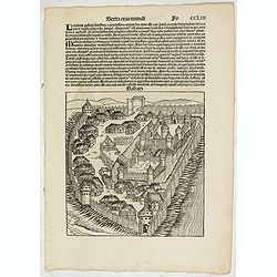
Sexta Etas Mudi. (With view of Sabatz.) Folio CCLIII
A imaginary view of Sabatz, Turkey: however the earliest obtainable view of this period.Further including presentations of the popes Sixtus IV and Innocentius VIII. Pag...
- $200 / ≈ €187
Place & Date: Nuremberg, 12 July 1493
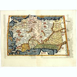
Tabula I Asiae.
Ptolemaic map of Turkey.From Lorenz Fries' edition of Ptolemy's Geographia, largely based on the 1513 map by Waldseemuller. "The elaborate Renaissance woodcut panels...
- $750 / ≈ €702
Place & Date: Vienna, 1490, 1535
Natolia.
A miniature map of Turkish Natolia, published by Petrus Bertius in Amsterdam, at the beginning of the seventeenth century. This attractive small map features hatching in ...
- $150 / ≈ €140
Place & Date: Amsterdam, 1606
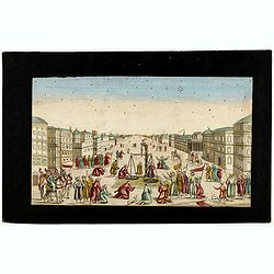
Imaginary view of a square with Muslims festival.
Imaginary view of a square with Muslims festival. A so called optical print.
- $200 / ≈ €187
Place & Date: Paris, ca. 1750
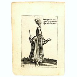
Ianizer excubias agens constantinapo lipro Aulu Imperatoris.
Costume plate published by Pietro Bertelli in his "Diversarum nationum habitus", a sixteenth-century Italian costume book. The work was published with fold-out ...
- $60 / ≈ €56
Place & Date: Padua, 1589
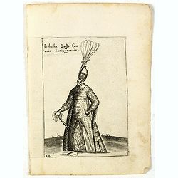
Bolucha Bassa Centurio Ianizerorum.
Costume plate published by Pietro Bertelli in his "Diversarum nationum habitus", a sixteenth-century Italian costume book. The work was published with fold-out ...
- $60 / ≈ €56
Place & Date: Padua, 1589
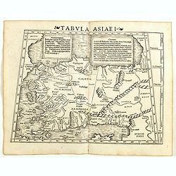
Tabula Asiae I (Turkey)
The first edition of Munster's map of Turkey, based upon Claudius Ptolemy which appeared in his "Geographia Universalis", first published in 1540. The Geographi...
- $500 / ≈ €468
Place & Date: Basel, Heinrich Petri, 1545
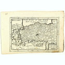
La Turquie en Asie.
Uncommon miniature map of Turkey, Cyprus, Palestine, Armenia, Iran and Iraq. From Pierre Duval's La Geographie Universeille dated 1676. Following his Cartes de geographie...
- $90 / ≈ €84
Place & Date: Paris, 1676
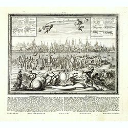
Constantinopolitanae urbis effigies ad vivum expressa.
Extremely rare panoramic view of Istanbul published by Jacob Koppmayr. With a numbered key (1-29) to principal places in town. Jacob Koppmayr was a printer and publisher ...
- $900 / ≈ €842
Place & Date: Augsburg, 1689
Ladimistri nel arcipelago. (Edremit)
Magnificent bird's eye-town-view of Edremit on the west coast of Turkey, not far from the Greek island Lesbos. It is situated at the tip of the gulf with the same name (G...
- $150 / ≈ €140
Place & Date: Antwerp, c.1690