Browse Listings in Asia > South East Asia
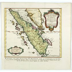
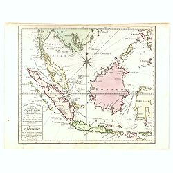
Carte de l'Isle de Sumatra. . . / Kaart van het Eiland Sumatra. . .
Map of Sumatra, also showing the tip of the Malay Peninsula and the Straits of Singapore. An unusually detailed map of the area, showing many coastal features, shoals, ba...
Place & Date: The Hague, Pierre d'Hondt, 1753
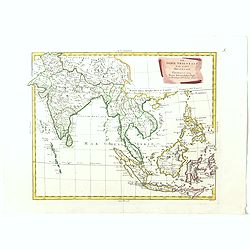
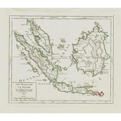
Le Indie Orientali E Il Loro Arcipelago . . .
Striking map of the region from the Gulf of Bengal to Hainan, centered on the Malay Peninsula, Straits of Malacca, Sumatra, Java and Philippines.This is the uncommon edit...
- $500 / ≈ €468
Place & Date: Venise, 1794-1796

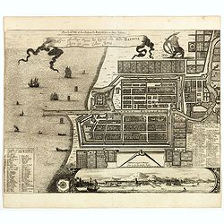
Vue et Description de Quelques-Uns des Principaux Forts des Hollandois dans les Indes .
Interesting sheet with seven detailed views illustrating the most important Dutch V.O.C. trading outposts and fortified colonial possessions in the East Indies, including...
Place & Date: Amsterdam, 1720
Plan de la Ville et du Chateau de Batavia en l'Isle de Iava / Ware affbeeldinge wegens het Casteel ende Stadt Batavia gelegen opt groot Eylant Java.
Detailed East-oriented plan of Jakarta former Batavia on Java / Indonesia. With bird's-eye view from sea side, various ships and a lion. Two inset keys with detailed desc...
Place & Date: Leiden, 1730
Selling price: $300
Sold in 2019
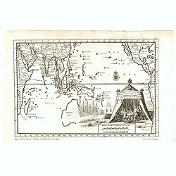
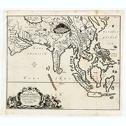
Indien onder den Heer Lopo Vaz De Sampayo, als Gouverneur Generaal tot aan Nieuw-Spanje in American on Kusten van Peru en Chili bevaaren.
Most decorative and scarce item, centred on Indonesia, including an incomplete coast of Australia, and west coast of America. The South Pacific is occupied by a large tit...
- $500 / ≈ €468
Place & Date: Leiden, 1707
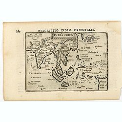
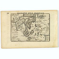
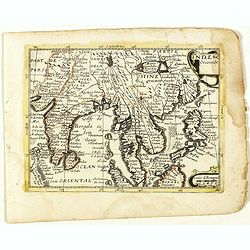
India Orien.
A miniature map showing India and the islands of Borneo, New Guinea, Sumatra, Java, etc.Korea as an enlonged peninsular and one town marked.First published in 1598 in his...
- $400 / ≈ €374
Place & Date: Amsterdam, Cornelis Claes, 1606
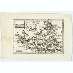
The Philippine Islands and others of the East Indies. . .
Herman Moll's 'busy' map of South East Asia and the Philippines, published in the middle of the eighteenth century in London. The map includes numerous small islands, Sum...
- $280 / ≈ €262
Place & Date: London, ca 1750
Les Indes Orientales.. tirées du Neptune Oriental..
Finely and crisply engraved map centered on the Bay of Bengal, encompassing the Indian subcontinent and the Indochinese Peninsula.Venetian edition of Giles Didier Robert ...
- $450 / ≈ €421
Place & Date: Venice, 1779 - 1784
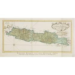
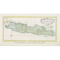
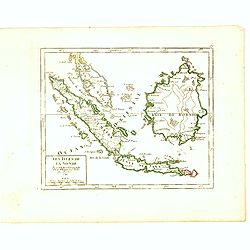
Nouvelle carte de l'Isle de Java.
A very nice map centred on the island of Java.With French text in title cartouche and an additional title in Dutch underneath the map.Read more Early maps of South East A...
Place & Date: Amsterdam, 1773
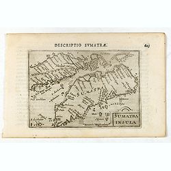
Sumatra Insula.
A miniature map of Sumatra containing detailed geography and nomenclature around the entire island. The neighbouring coast of the Malay Peninsula is shown, including Sing...
- $450 / ≈ €421
Place & Date: Amsterdam/Frankfurt 1609
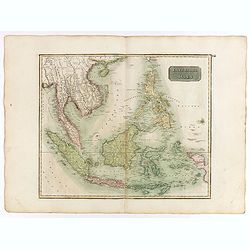
East India Isles.
Somewhat later but very finely engraved and detailed map of the Indonesian archipelago, including Thailand, Philippines and southern part of Taiwan.
Place & Date: Edinburgh, 1817
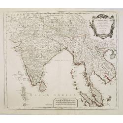
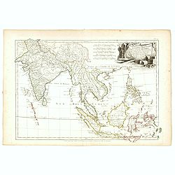
D'Indize kusten van Bengale, Pegu, Malacca en Siam Tot in China. . .
Map of Indonesia, Malacca with Singapore (Cingapura) and Taiwan in upper right corner. In lower left a fine title cartouche showing Duarte de Menezes.Although not renowne...
- $450 / ≈ €421
Place & Date: Leiden, 1707
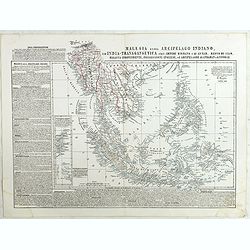
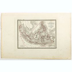
Malesia ossia Arcipelago Indiano, ed India-Transgangetica . . .
Attractive map of the Southeast Asia by a cartographer from Naples, listing his cartographic sources and giving political and statistical information on the areas covered...
- $450 / ≈ €421
Place & Date: Naples, 1848
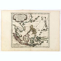
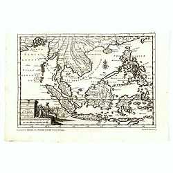
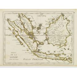
Les Isles de la Sonde, Moluques, Philippines, Carolines, et Marlannes.
Nice detailed map of southeast Asia, showing the Malay Peninsula, Sumatra, Java and the island of Borneo. Engraved by E. Dussy and the title cartouche by Arrivet. From hi...
- $275 / ≈ €257
Place & Date: Paris, ca. 1762
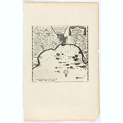
La Rade de Batavia . . .
Beautifully engraved map with elaborate cartouche of present-day Jakarta. From van der Aa's very rare work "La galerie agreable du Monde".
- $300 / ≈ €281
Place & Date: Leiden, 1719
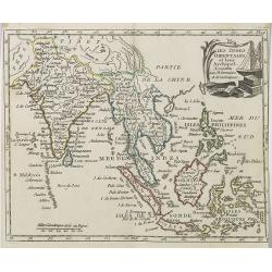
Les Indes Orientales et leur Archipel . . .
Map of India, the Maldive Islands, the Indonesian and Philippine Islands, from Atlas moderne portatif composé de vingt-huit cartes sur toutes les parties du globe terres...
- $300 / ≈ €281
Place & Date: Paris, Prudhomme, Levrault, Debray, 1806
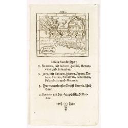
Insulae Sondae.
Rare small map of South East Asia, from "Kurtze bundige abbild und vorstellung der gantzen welt." by Johann Ulrich Muller. A second edition was published in Fra...
- $300 / ≈ €281
Place & Date: Ulm, 1692
India Orientalis.
This lovely miniature map shows the East Indies, stretching from Persia to China and Japan, down to Java, and part of Papua new Guinea. Published by Petrus Bertius, in Am...
Place & Date: Amsterdam, 1606
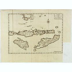
Kaart van de Zuyd-Wester Eylanden van Banda.
Map of the Banda islands.François Valentijn (1666-1727), a missionary, worked at Amboina from 1684 to 1694 and 1705 to 1713 and travelled extensively in the VOC's lands....
- $400 / ≈ €374
Place & Date: Amsterdam, 1726
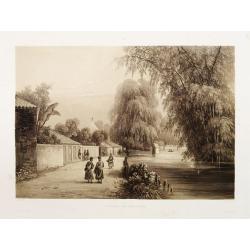
Rivière de Sourabaya.
Early view of Surabaya on the island of Java after Paris and engraved in aquatint technique by Sigismond Himely (1801-1872). Published as plate 61 in Voyage autour du mon...
- $300 / ≈ €281
Place & Date: Paris, Finot, 1835
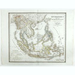
Hinter Indien nebst den Hinterindischen Inseln entwrfen und Gezeichnet von C.F. Weiland . . . 1828
Scarce map of Southeast Asia, including southern China, the Philippines, the Malaysian Peninsula and extending south to Java, Timor and the northern tip of Australia.The ...
- $300 / ≈ €281
Place & Date: Weimar, 1829
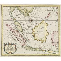
Carte des Isles de Java, Sumatra, Borneo. . . Malaca et Banca. . . / Kaart van de Eilanden van Java. . .
Dutch edition of this map of Indonesia prepared by N. Bellin and published by Pierre d'Hondt in Amsterdam. Jaques Nicolas Bellin (1703-1772) was one of the most important...
- $400 / ≈ €374
Place & Date: Amsterdam, 1747
Les Isles de la Sonde.
Small detailed map of southeast Asia, showing the Malay Peninsula, Sumatra, Java and the island of Borneo. Dated 1769.From Atlas Portatif Universel, by Robert de Vaugondy...
- $200 / ≈ €187
Place & Date: Paris, later than 1769
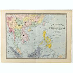
Carte de l'Asie orientale comprenant l'empire chinois le Japon les états de l'Indo-Chine et le grand archipel d'Asie ou Malaisie.
Detailed map of Malaysia, Thailand, China, Taiwan, and good detail in Philippines. Lower part of a 2-sheet map.
Place & Date: Paris, 1862
Les Indes Orientales et leur Archipel. . .
General map of Indonesia, extending from India to the Philippines and New Guinea.Ornated with a decorative title cartouche. Boundaries outlined in hand color.From theAtla...
- $250 / ≈ €234
Place & Date: Paris, ca 1783

Du sang à l'aube.
Original lithographed poster for the Spanish movie "Blood at dawn" (1948) directed by Rafael Gil, based on the novel by Blasco Ibanez. Poster designed by Duccio...
Place & Date: Paris, 1948
Nouvelle carte de l'Isle de Java.
A very nice map centered on the island of Java. With French text in title cartouche and an additional title in Dutch underneath the map.Read more Early maps of South East...
Place & Date: Amsterdam, 1773
Tabula Geographica Hydrophylacium Asiae Majoris exhibens, quo Omnia Flumina sive proxime sive remote per occultos maeandros Originem suam Sortiuntur.
Rare and Interesting map showing Asia from Arabia in the west until China, Japan, Korea and Philippines with Indonesia. From Kircher's "Mundus Subterranaeus". ...
- $300 / ≈ €281
Place & Date: Amsterdam, 1665
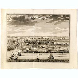
Astjien.
Nice bird's eye-view of the Town of Atjien on the northernmost point of Sumatra by François Valentijn (1666-1727), a missionary, who worked at Amboina from 1684 to 1694 ...
- $225 / ≈ €211
Place & Date: Amsterdam, 1726
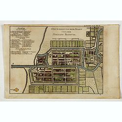
Grundriss von der Stadt und dem Schlosse Batavia.
Uncommon plan of the town and fortress of Batavia. The plan is based on the earlier, much larger map of Batavia published by Clement de Jonghe in 1650. From 'Algemeine We...
- $175 / ≈ €164
Place & Date: Halle, 1763-1792
![[View of the arrival of Cornelis de Houtman's fleet at Bantam, Java.].](/uploads/cache/37937-250x250.jpg)
[View of the arrival of Cornelis de Houtman's fleet at Bantam, Java.].
Engraved map of Bantam on Java with a lettered key (A-N) showing the arrival of Cornelis de Houtman’s fleet at Bantam, Java in 1596. Houtman’s four vessels, the Amste...
- $200 / ≈ €187
Place & Date: Amsterdam, Cornille Nicolas, 1609
Inde Orientale. (22).
Scarce map of India, the East Indies, Philippines and Malaysia published by Antoine de Fer in 1661 or 1662 in "Cartes de géographie revues et augmentées". Wit...
- $250 / ≈ €234
Place & Date: Paris, Antoine de Fer, 1657 but 1661 or 1662
Carte Des Isles de Java, Sumatra, Borneo.. Malaca et Banca..
Jacques Nicolas Bellin (1703-1772) was one of the most important and proficient French cartographers of the mid-eighteenth century. He was appointed the first Ingenieur H...
- $300 / ≈ €281
Place & Date: Paris, 1752
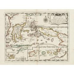
Les Iles Molvcques, Celebes, Gilolo. . .
Map of the Indian Ocean Islands of the Moluccas Islands prepared by N.Sanson and published by Pierre Mariette.Published in an early edition of the small Sanson atlas L'Eu...
Place & Date: Paris, P. Mariette, 1667
Selling price: $150
Sold in 2009
Les Isles de la Sonde Par le Sr. Robert de Vaugondy fils de Mr. Robert Geog. Ord du Roi avec Privilege 1749.
Small detailed map of of South East Asia, including Malaysian Peninsular with Singapore. From Atlas Portatif Universel, by Robert de Vaugondy.Page 170 outside border top...
- $200 / ≈ €187
Place & Date: Paris, 1749
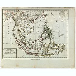
Presqu'Île au dela du Gange et Archipel de l'Inde.
Detailed map of Indonesia with Philippines and Taiwan. Engraved by P.F.Tardieu. From "Mentelle's Atlas Universe".
- $150 / ≈ €140
Place & Date: Paris, ca 1784 / 1806
Isles de la Sonde.
Fine map of the islands of Java, Sumatra, Borneo, Bali and part of the Malay peninsular. George Louis Le Rouge was active from 1740- till 1780 as a publisher, and was app...
- $200 / ≈ €187
Place & Date: Paris, 1756
Carte de la Malaisie ou Grand archipel d'Asie.
Nice map of Indonesia, Philippines, Malacca with Singapore and tip of Northern Australia. Engraved by Thierry. Countries and regions in delicate out line color. Includes ...
Place & Date: Paris, 1835
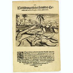
Plants, including the canior, diringuo, pucho and chiabe.
In the Indies there are many delightful plants, which include the ‘costus indicus’ (named by the Malays 'pucho') that has a wonderful aroma. Then there is the ‘cala...
Place & Date: Frankfurt, 1598
![[Bantam].](/uploads/cache/37970-250x250.jpg)
[Bantam].
Text engravings from "Premier livre de l'histoire de la navigation aux Indes Orientales, par les hollandois, et des choses a eux advenues . . . ", being the cla...
Place & Date: Amsterdam, Cornille Nicolas, 1609