Search Listings matching "philippines" in Asia > South East Asia
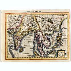
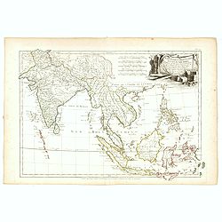
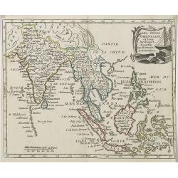
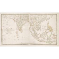
India Orientalis.
Map covering India, Thailand, Philippines, Northern Borneo and the coast of Southern China. From the rare Cloppenburg edition "Atlas Sive Cosmographicae Meditationes...
- $550 / ≈ €470
Place & Date: Amsterdam, 1630
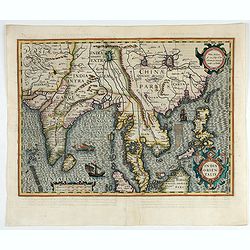
India Orientalis.
Published in Hondius' editions of the Mercator Atlas from 1606 onwards, showing the Indian subcontinent, the Malay Peninsula, Siam and Cambodia, China and the Philippines...
- $2000 / ≈ €1710
Place & Date: Amsterdam, 1630

India Orientalis.
Published in Hondius' editions of the Mercator Atlas from 1606 onwards, showing the Indian subcontinent, the Malay Peninsula, Siam and Cambodia, China and the Philippines...
Place & Date: Amsterdam, 1630
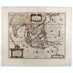
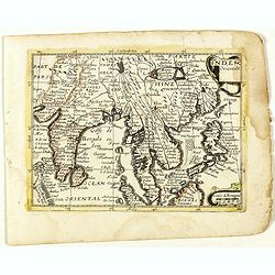
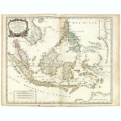
India quae Orientalis dicitur, et Insulae Adiacentes.
Map of South East Asia, noteworthy for being one of the first maps to include, albeit incompletely, the discoveries made by the Dutch vessel Duyfken in 1605-1606 in the G...
- $1750 / ≈ €1496
Place & Date: Amsterdam, 1638
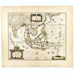
India quae Orientalis dicitur, et Insulae adiacentes.
A fine map of South East Asia, extending from India to Tibet to Japan to New Guinea. Formosa appears on this map, and even parts of Japan and Australia are seen. A handso...
- $1850 / ≈ €1582
Place & Date: Amsterdam, 1640

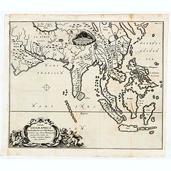
Carta prima Generale dell' Asia.
FIRST STATE of Robert Dudley's general chart of the Persian Gulf, going east through India to the southeastern coast of China showing Macau and the area of present-day Ho...
Place & Date: Florence, 1646
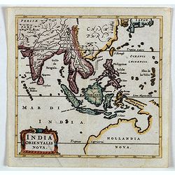
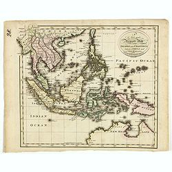
India Orientalis Nova.
Charming uncommon miniature map showing the northern two-thirds of Australia pre-discoveries by Captain Cook, but showing discoveries by Abel Tasman in 1642. The map show...
- $750 / ≈ €641
Place & Date: Amsterdam, 1659
Inde Orientale. (22).
Scarce map of India, the East Indies, Philippines and Malaysia published by Antoine de Fer in 1661 or 1662 in "Cartes de géographie revues et augmentées". Wit...
- $250 / ≈ €214
Place & Date: Paris, Antoine de Fer, 1657 but 1661 or 1662
Tabula Geographica Hydrophylacium Asiae Majoris exhibens, quo Omnia Flumina sive proxime sive remote per occultos maeandros Originem suam Sortiuntur.
Rare and Interesting map showing Asia from Arabia in the west until China, Japan, Korea and Philippines with Indonesia. From Kircher's "Mundus Subterranaeus". ...
- $300 / ≈ €256
Place & Date: Amsterdam, 1665
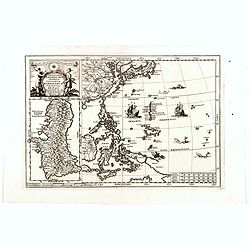
![Isole dell 'India cioè le Molucche le Filippine e della Sonda . . . [East Indies].](/uploads/cache/39593-250x250.jpg)
Isole dell 'India cioè le Molucche le Filippine e della Sonda . . . [East Indies].
In lower left hand corner a large title cartouche, decorated with mermaids, mermen and playful putti. A scarce, uncommon, late 17th century map of South East Asia, based ...
- $1800 / ≈ €1539
Place & Date: Rome, 1683
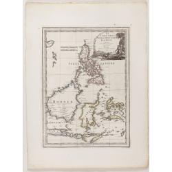
Nova Et Vera Exhibitio Gerographica Insularum Marianarum . . .
Attractive map of the Philippines, Japan, Korea and Indonesia with an inset of the island Guam, by the Jesuit Heinrich Scherer, printed in for Scherer's 'Atlas Novus'. Se...
- $1200 / ≈ €1026
Place & Date: Munich, c.1702
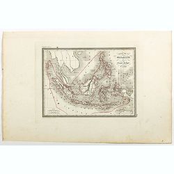
Archipel des indes Orientales
A finely engraved map depicting South East Asia with very good detail on the Philippines. Decorative title cartouche. From Atlas Universel of Gilles and Didier Robert de ...
Place & Date: Paris, 1750
The Philippine Islands and others of the East Indies. . .
Herman Moll's 'busy' map of South East Asia and the Philippines, published in the middle of the eighteenth century in London. The map includes numerous small islands, Sum...
- $280 / ≈ €239
Place & Date: London, ca 1750
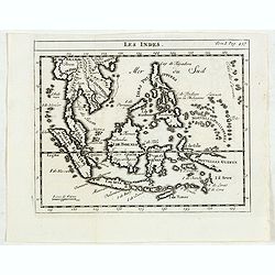
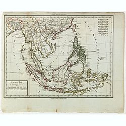
Les Indes.
Scarce small map of South East Asia with Indonesia, Thailand, Philippines and including New Guinee, based on cartography of Guillaume Delisle. Published in "Nouveau ...
- $125 / ≈ €107
Place & Date: Paris, La veuve Lottin & Butard, P.G. Le Mercier, Rollin, 1751
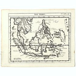
Les Indes.
A scarce small map of South East Asia with Indonesia, Thailand, Philippines and including New Guinee, based on cartography of Guillaume Delisle. Published in "Nouvea...
- $200 / ≈ €171
Place & Date: Paris, ca. 1752
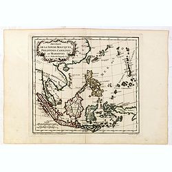
Les Isles de la Sonde, Moluques, Philippines, Carolines, et Marlannes.
Nice detailed map of southeast Asia, showing the Malay Peninsula, Sumatra, Java and the island of Borneo. Engraved by E. Dussy and the title cartouche by Arrivet. From hi...
- $275 / ≈ €235
Place & Date: Paris, ca. 1762
Histoire universelle depuis le commmencement du monde jusqu'a present. Tome Vingt-unieme. Portugais, Espagnols, Hollanois etc
Volume 21 of this informative publication with a description of the discoveries, conquests, and settlements by the Portuguese, Spaniards, English, and Dutch in Southeast ...
- $1200 / ≈ €1026
Place & Date: Amsterdam, Leipzig, 1763
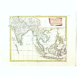
Les Indes Orientales et leur Archipel. . .
General map of Indonesia, extending from India to the Philippines and New Guinea.Ornated with a decorative title cartouche. Boundaries outlined in hand color.From theAtla...
- $250 / ≈ €214
Place & Date: Paris, ca 1783
Le Indie Orientali E Il Loro Arcipelago . . .
Striking map of the region from the Gulf of Bengal to Hainan, centered on the Malay Peninsula, Straits of Malacca, Sumatra, Java and Philippines.This is the uncommon edit...
- $500 / ≈ €427
Place & Date: Venise, 1794-1796
A new and Accurate map of the islands and Channels between China and New Holland.
Highly detailed map of Southeast Asia, covering the region between Formosa and Hainan islands in the North and Australia in the South.Including Burma to Taiwan with parts...
- $600 / ≈ €513
Place & Date: Edinburgh, 1801
Presqu'Île au dela du Gange et Archipel de l'Inde.
Detailed map of Indonesia with Philippines and Taiwan. Engraved by P.F.Tardieu. From "Mentelle's Atlas Universe".
- $150 / ≈ €128
Place & Date: Paris, ca 1784 / 1806
Les Indes Orientales et leur Archipel . . .
Map of India, the Maldive Islands, the Indonesian and Philippine Islands, from Atlas moderne portatif composé de vingt-huit cartes sur toutes les parties du globe terres...
- $300 / ≈ €256
Place & Date: Paris, Prudhomme, Levrault, Debray, 1806
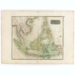
East India Isles.
Somewhat later but very finely engraved and detailed map of the Indonesian archipelago, including Thailand, Philippines and southern part of Taiwan.
Place & Date: Edinburgh, 1817
Charte von Ostindien Diesseits Und Jenseits Des Ganges / nach den neuesten astronomischen Beobachtungen auch andern sichern Hülfsmitteln neu entworfen. . .
Prepared by I.C.M.Reinecke giving good detail in India, Indonesia and the Philippines.
- $800 / ≈ €684
Place & Date: Weimar, 1822
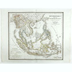
Hinter Indien nebst den Hinterindischen Inseln entwrfen und Gezeichnet von C.F. Weiland . . . 1828
Scarce map of Southeast Asia, including southern China, the Philippines, the Malaysian Peninsula and extending south to Java, Timor and the northern tip of Australia.The ...
- $300 / ≈ €256
Place & Date: Weimar, 1829
Carte de la Malaisie ou Grand archipel d'Asie.
Nice map of Indonesia, Philippines, Malacca with Singapore and tip of Northern Australia. Engraved by Thierry. Countries and regions in delicate out line color. Includes ...
Place & Date: Paris, 1835
Le Insole della Sonda
Cassini’s splendid early map of Philippines, and Indonesia..Taken from the ""Nuovo Atlante Geografico Universale delineato sulle ultime osservazioni", pu...
Place & Date: Rome, Calcography, 1797-before 1839
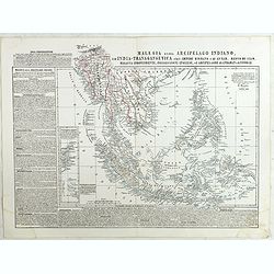
Malesia ossia Arcipelago Indiano, ed India-Transgangetica . . .
Attractive map of the Southeast Asia by a cartographer from Naples, listing his cartographic sources and giving political and statistical information on the areas covered...
- $450 / ≈ €385
Place & Date: Naples, 1848
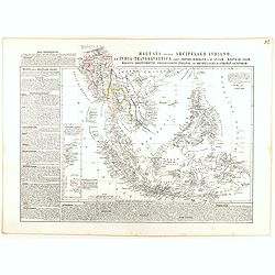
Malesia ossia Arcipelago Indiano, ed India-Transgangetica.
Attractive map of the Southeast Asia by a cartographer from Naples, listing his cartographic sources and giving political and statistical information on the areas covered...
- $500 / ≈ €427
Place & Date: Naples, 1848
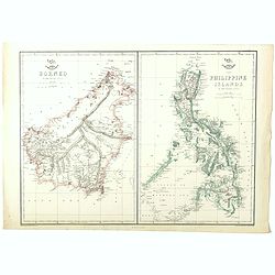
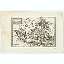
Borneo (together with) The Philippine Islands.
Two maps on one sheet. Both maps are highly detailed, filled with place names. The Philippines are shown from the Bashee Islands in the north to the Sooloo Archipelago in...
Place & Date: London, ca. 1858
Vicariato aplico di Bataviaa E prefettura di Labuan nella Oceania.
Map showing the boundaries of Catholic dioceses in Southeast Asia in 1850s, with some detail of Java, Borneo, Sumatra. Including the Philippines, but without detail. This...
- $1000 / ≈ €855
Place & Date: Rome, 1858-1859
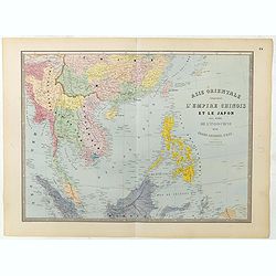
Carte de l'Asie orientale comprenant l'empire chinois le Japon les états de l'Indo-Chine et le grand archipel d'Asie ou Malaisie.
Detailed map of Malaysia, Thailand, China, Taiwan, and good detail in Philippines. Lower part of a 2-sheet map.
Place & Date: Paris, 1862
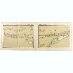
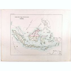
De kleine Soenda-Eilanden. Schaal van 1:800000.
Very detailed two sheet map of Soenda Islands, taken from "Atlas van Nederlandsch Oost- en West-Indie", prepared by doctor I. Dornseiffen, and published by publ...
- $30 / ≈ €26
Place & Date: Amsterdam, Seyffardt, 1884
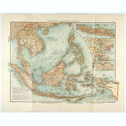
Hinterindien und Malayischer Archipel.
Map of South East Asia with four insets. Shows settlements, roads, railways, telegraph cables, etc. A color key to Dutch, French, British, and Portuguese occupations. Inc...
Place & Date: Leipzig, 1905

Ce que les Anglo-Saxons ont perdu en Extrême-Orient.
Illustrated Vichy propaganda War & Propaganda poster showing a map of South East Asia, with Indonesia, Philippines, Thailand, etc., among photos and explanations abou...
Place & Date: Paris, 1943

![[Title page for ] Atlas de la Terre ou Monde Terrestre - Tome premier]](/uploads/cache/47761-250x250.jpg)