Browse Listings in Asia > Malaysia / Singapore

Nouvelle carte des mers comprises entre le détroit de Banca et P°. Timon avec la partie orientale du détroit de Malacca.
Important French chart of the tip of Malaysia with Singapore. Latitude and longitude scales, compass rose and system of rhumb lines, soundings near coast and in bay areas...
Place & Date: Paris, 1745

Mer de Chine - Detroit De Singapour Partie Comprise Entre Singaour et Le Dett. De Malacca d'apres les travaux du Commr. J.W. Reed de la Marine Royale d'Angleterr, ...
A detailed chart of Singapore Strait, drawn from an English Chart by J.W. Reed, who surveyed Singapore and environs between 1865 and 1869, aboard the H.M.S. Rifleman.The ...
Place & Date: Paris, 1873
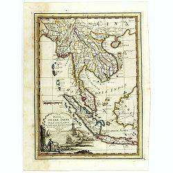
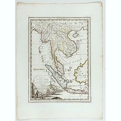
La Penisola delle Indie di la' dal Gange con parte delle Isole della Sonda delineate sulle ultima osservazioni.
First edition on laid paper. Cassini’s splendid early map of Indochina, from Bangladesh in the west to central Borneo in the east, and southern China in the north, to B...
Place & Date: Rome, 1797
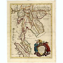
Penisola Dell India di la dal Gange Diusa ne i Regni, che in essasi contengono et accresciuta di varie notizie. Da Giacomo Cantelli da Vignola e conforme le Relationi di alcuni Padri della Compa di Giesu di Monsu Tavernier . . . 1683
Giacomo Rossi's fine late 17th century map of Malaysia, Thailand, Cambodia and part of Sumatra.. Engraved by Franciscus Donia. Issued in Il Mercurio geografico In lower r...
Place & Date: Rome, 1683-1688

Mer de Chine - Detroit De Singapour Partie Comprise Entre Singaour et Le Dett. De Malacca d'apres les travaux du Commr. J.W. Reed de la Marine Royale d'Angleterr...
Mer de Chine - Detroit De Singapour Partie Comprise Entre Singaour et Le Dett. De Malacca d'apres les travaux du Commr. J.W. Reed de la Marine Royale d'Angleterr, execute...
- $2500 / ≈ €2339
Place & Date: London, 1871

Sincapour.
Early view of Singapore after Paris and engraved in aquatint technique by Sigismond Himely (1801-1872). Published as plate 28 in Voyage autour du monde par les mers de l'...
Place & Date: Paris, Finot, 1835
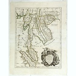
Penisola dell India di là dal Gange. . .
Giacomo Rossi's fine late 17th-century map of Malaysia, Thailand, Cambodia and part of Sumatra. Issued in Il Mercurio geografico In the lower right-hand corner a large ti...
- $2500 / ≈ €2339
Place & Date: Rome, 1683-1688
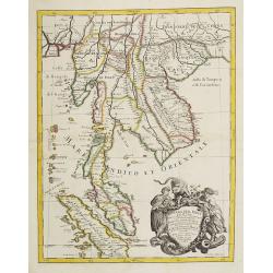
Penisola Dell India di la dal Gange Diusa ne i Regni, che in essasi contengono et accresciuta di varie notizie. Da Giacomo Cantelli da Vignola e conforme le Relationi di alcuni Padri della Compa di Giesu di Monsu Tavernier . . .
Giacomo Rossi's fine late 17th-century map of Malaysia, Thailand, Cambodia and part of Sumatra. The region is shown divided into kingdoms, including Tonkin, Cochinchina, ...
- $2200 / ≈ €2059
Place & Date: Rome, 1683-1688
La Penisola delle Indie di la' dal Gange con parte delle Isole della Sonda delineate sulle ultima osservazioni.
Cassini’s splendid early map of Indochina, from Bangladesh in the west to central Borneo in the east, and southern China in the north, to Bali in the south. Good detail...
Place & Date: Rome, Calcography, 1797-before 1839
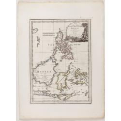
Le Insole della Sonda
Cassini’s splendid early map of Philippines, and Indonesia..Taken from the ""Nuovo Atlante Geografico Universale delineato sulle ultime osservazioni", pu...
Place & Date: Rome, Calcography, 1797-before 1839