Browse Listings in Asia > Malaysia / Singapore
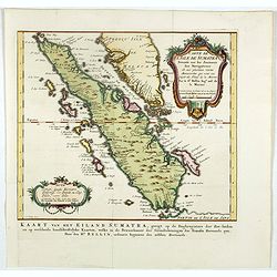
Carte de l'Isle de Sumatra. . . / Kaart van het Eiland Sumatra. . .
Map of Sumatra, also showing the tip of the Malay Peninsula and the Straits of Singapore. An unusually detailed map of the area, showing many coastal features, shoals, ba...
Place & Date: The Hague, Pierre d'Hondt, 1753
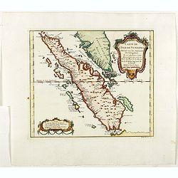
Carte de L'Isle de Sumatra Dressee sur les Journaux des Navigateurs . . .
Detailed map of Sumatra and Malacca, centered on Singapore and including the southern portion of the Malaysian peninsula. With "Detroit de Sincapour" and severa...
- $350 / ≈ €328
Place & Date: Paris, ca. 1750
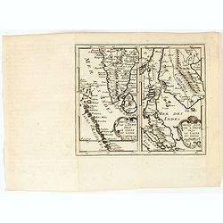
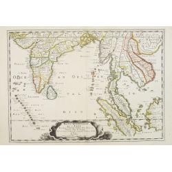
Presqu'Isle de l'inde deça le Golfe du Gange/Presqu'Isle de l'Inde dela le Golfe du Gange.
Two maps on one sheet, one depicting India, Sri Lanka and the Maldives Islands (13,5 x 8 cm) and the otherone Cambodia, Thailand, Singapore and Malaysia (13,5 x 8 cm). F...
- $300 / ≈ €281
Place & Date: Leon de Francia (Lyon), Jaime Certa, 1739
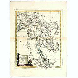
Regni D'Aracan Del Pegu Di Siam Di Camboge E Di Laos . . . 1785
Striking regional map centered on Thailand and Vietnam, extending from the Singapore to India, and north to Tibet. Decorative scroll title cartouche.
- $500 / ≈ €468
Place & Date: Venise, 1785
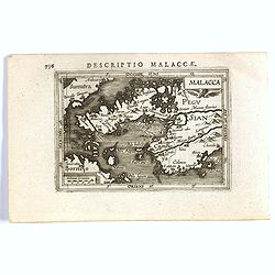
Malacca.
A nice miniature map of Malacca, A Malaysian state on the southern Malay peninsular, next to the Strait of Malacca. North is orientated to the left Published by Petrus B...
- $300 / ≈ €281
Place & Date: Amsterdam, 1606
Partie Meridionale de l'Inde en deux presqu'isles. . .
Sanson's important mid-seventeenth century map of India and Southeast Asia, with the engraved date 1686, with the address "Aux Galleries du Louvre" added in bro...
- $800 / ≈ €749
Place & Date: Paris, 1686
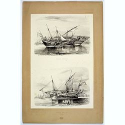
Praos Malais.
A pair of attractive Malay fishing boats. Plate 133 taken from the 'Voyage au Pole et dans L'Oceanie…' Departing in late 1837 in the Astrolabe and Zélée, Dumont D'Urv...
- $50 / ≈ €47
Place & Date: Paris, 1842
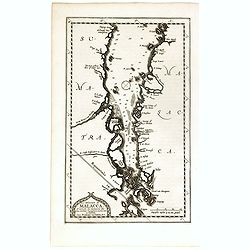
Le détroit de Malacca . . .
Map of Malacca. The map details the Strait of Malacca from P. Peru and Tanjong Goeree to Lingen and Pulu Panjang. Malacca and Ihor (Johore), along with numerous other coa...
- $500 / ≈ €468
Place & Date: Leiden, 1712
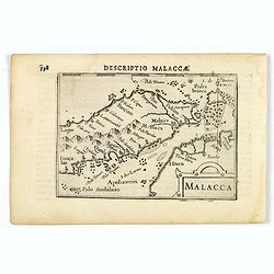
Malacca.
FIRST IMPRINT FROM THE NEWLY ENGRAVED PLATES IN 1616. - A rare miniature map of Malacca, Borneo, part of Sumatra . Latin text on verso.First published in 1598 in his Caer...
- $500 / ≈ €468
Place & Date: Amsterdam, J. Hondius, 1616
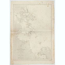
Mer de Chine - Carte des Iles et Détroits entre Singapoure et le Détroit de Banca. Dréssée d'après le stravaux Anglais et Hollandais plus récents, par Mr. L. Manen . . . 1866
A nautical chart of Singapore and neighboring islands. The first edition of the chart was published in 1866 from French and English sources, this is the corrected version...
- $2000 / ≈ €1871
Place & Date: London, 1866-1871