Browse Listings in Asia > Korea (and Japan)
![CH'ONHA CHIDO [Atlas of all under Heaven]](/uploads/cache/33625-250x250.jpg)
CH'ONHA CHIDO [Atlas of all under Heaven]
The Ch’onha chido [Atlas of all under Heaven] is a late 18th century copy of the traditional Korean atlas produced in the early Choson dynasty (1392-1910). One of the m...
Place & Date: Korea, ca. 1790
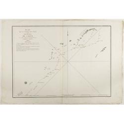
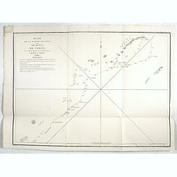
Plan de la partie des Isles ou Archipel de Corée.
Showing the track of La Perouse along the southern most tip of Korea, with Quelpaerts Islands (now-a-days called Jeju, with the volcano Halla-san (Halla Mountain) clearly...
- $750 / ≈ €702
Place & Date: Paris, 1797
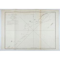
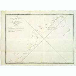
Plan de la partie des Isles ou Archipel de Coree.
Showing the track of La Perouse along the southernmost tip of Korea, with Quelpaerts Islands (nowadays called Jeju, with the vulcano Halla-san (Halla Mountain) is clearly...
- $350 / ≈ €328
Place & Date: Paris, 1797
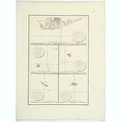
Plan de la partie de l'ile de quelpaert. . . / Plan de l'ile Hoapinsu. . . / Plan de l'ile Dagelet. . . / Plan de la partie de l'ile de Botol. . . / Plan de l'ile de Kumi. . .
Five plans on a folio sheet. These charts include Cheju Do, Korea (Quelpaert Is.), Kume-Shiwa, Okinawa (Kumi), and Ullung Do (Dagelet).Including one of the earliest maps ...
- $750 / ≈ €702
Place & Date: Paris, 1797
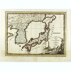
Le Isole del Giappone e la Corea delineate sulle ultima osservazioni.
First edition on laid paper. Cassini’s splendid early map of Japan and Korea, with large decorative title cartouche. The map has a very unusual, almost triangular, repr...
Place & Date: Rome, 1797
Plan de la partie des iles, ou archipel de Coree, vue au mois de Mai 1787 par les Fregates Francaises la Boussole et l'Astrolabe. . . .
Showing the track of La Perouse along the southernmost tip of Korea, with Quelpaerts Islands (nowadays called Jeju, with the volcano Halla-san (Halla Mountain) clearly no...
- $450 / ≈ €421
Place & Date: L'Imprimerie de la Republique, An V, 1797

Carte des découvertes fautes en 1787 dans les Mers de Chine et de Tartarie par les Frégates Françaises la Boussole et l'Astrolabe. . . ée. Feille.
La Pérouse's important large-scale of Northern Japan, Hokkaido, the Kuriles, the tip of Kamschatka, and the northern part of Korea.Showing the track of Perouse from 27 ...
Place & Date: Paris, 1797
Plan de la partie des iles, ou archipel de Coree, vue au mois de Mai 1787 par les Fregates Francaises la Boussole et l'Astrolabe. . . .
Showing the track of La Pérouse along the southern most tip of Korea, with Quelpaerts Islands (now-a-days called Jeju, with the vulcano Halla-san (Halla Mountain) clearl...
- $400 / ≈ €374
Place & Date: L'Imprimerie de la Republique, An V, 1797
![Part of the island of Quelpart seen 21 may 1787. . . [5 maps on one sheet]](/uploads/cache/29902-250x250.jpg)
Part of the island of Quelpart seen 21 may 1787. . . [5 maps on one sheet]
Detailed maps of islands south of Korea. Of interest is the inset map of L'ile Dagelet (The Isle of Dagelet), the note in French says "Discovered by the French friga...
- $300 / ≈ €281
Place & Date: London, G. G. & J. Robinson, Paternoster Row, London, 1798

Plan of part of the islands or archipellago of Corea seen in May 1787 by the Boufsole and Astrolabe.
This is a representing the visit of the French Admiral and explorer, le Comte de La Pérouse to Korea in 1786. The tracks of La Perouse are shown.From 'Atlas du Voyage d...
Place & Date: London, 1798