Browse Listings in Asia > Korea (and Japan)
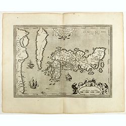
IAPONIAE INSULAE DESCRIPTIO.Ludoico Teisera auctore.
The map was based upon the manuscript draft supplied to Ortelius in about 1592 by the famous official Portuguese chart maker, Luis Teixeira , who was the cartographer t...
Place & Date: Antwerp, 1598

Asia carta di ciasete piu moderna. (Japan)
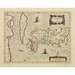
Rare FIRST STATE of this important map for Korea and Japan map of the Blancus/Moreira type, but adds a huge 'Jesso' filling the top of this old map. The map is of interes...
Place & Date: Florence, 1646-1647
Japoniae Nova Descriptio.
The map is identical in cartographic detail to the Hondius map of 1606 but newly designed ornate cartouches have been added. The three main islands of Japan are shown wit...
- $1800 / ≈ €1684
Place & Date: Amsterdam 1650

Isola del Giapone e penisola di Corea.
A most attractive and decorative map by Vincenzo Coronelli. An elaborate central title cartouche garlanded with intertwined flowers and dedicated to the Rev.de Fontaine o...
Place & Date: Venice, 1692

Paldobundo Province.
Woodblock printed map of Jeolla Province which was one of the historical Eight Provinces of Korea during the Kingdom of The map is drawn in "Paldo Bundo," styl...
Place & Date: 1710-1718

Japonia Regnum.
It is the first map to correctly show Korea as a peninsula. The rare Covens and Mortier issue of this important map of Japan and Korea, originally published by Blaeu. Thi...
Place & Date: Amsterdam, 1655 - 1720

Description geographique, historique, chronologique, politique, et physique de l'empire de la Chine et de la Tartarie chinoise.
First edition of this cornerstone of any collection of books on China, which is also among the rarest and most desirable of important Americana, included in Rare American...
Place & Date: Paris, P. G. Le Mercier, 1735

The Empire of China and Island of Japan. . .
The map is of interest for the use of East Sea, the sea between Korea and Japan, here called "Sea of Corea". Some interesting notations are made. From his atlas...
Place & Date: London, 1736

Description geographique, historique, chronologique, politique, et physique de l'empire de la Chine et de la Tartarie chinoise . . . du Thibet, & de la Coree. . .
Without the separately published atlas. Lacking 2 plates in vol.2 (Obseques at p.149 and Gin seng at p.180), one plate torn without a loss (vol.1, p.230), d4 vol.1 with a...
Place & Date: The Hague, H. Scheurleer, 1736

Nouvel atlas de la Chine, de la Tartarie chinoise, et du Thibet.
First edition of "the principal cartographic authority on China during the 18th century". It was the second major atlas of China produced in Europe following th...
Place & Date: The Hague, H. Scheurleer, 1737