
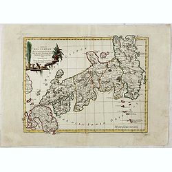
Carte des Isles du Japon Sequels est remarque la Route..
This uncommon map of Japan, a reduced version of his larger map, contains comments about the nature of the country. For instance, Ocsaqui (Okazaki, near Nagoya) is said t...
Place & Date: Paris / Amsterdam, 1679
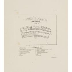
Nederlandsche Factory DEZIMA 1828.
Bird's-eye view of the manmade island of Deshima, a trading post of the V.O.C. from 1641 onward.Underneath the map a legend in Dutch and German with names of all the buil...
Place & Date: Leiden, 1832-1852
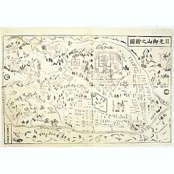
Nikko oyama no ezu (Pictorial Illustration of the Nikko mountains).
Fine map of the famous and well known pilgrimage site with pictorial temples and shrine labeled, and woods. Woodblock printed map, Edo Period (1615-1868), with publisher ...
Place & Date: Japan, c.1860
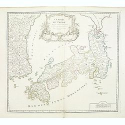
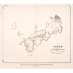
L'Empire du Japon divisé en sept principales parties. . .
Large map of Japan and Korea with a distinctively French style title cartouche containing two small landscapes.The map draws heavily on the previous work of Bellin, but i...
- $1000 / ≈ €936
Place & Date: Paris, 1750
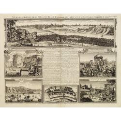
Vue et description de la Ville de Meaco Capitale du Japon. . .
The top part of the print shows a panoramic view of Meaco (Kyoto) at that time the capital of Japan, with a coach and horses in the foreground. Other parts show among oth...
- $750 / ≈ €702
Place & Date: Amsterdam, 1720
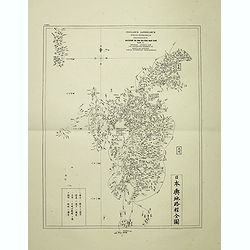
Insularum Japonicarum tabulae geographicae secundum opus NIPPON JO TSI RO TEI SEN TSU Tab. I Kiusui Insularum. . .
Fine map of the island if Kyushu, together with Tsushima Island with the bay of Nagasaki where in 1641 the man-made island of Deshima, trading post of the V.O.C. was est...
- $1000 / ≈ €936
Place & Date: Leiden, 1832-1852
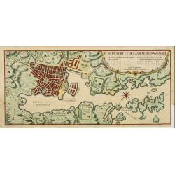
Plan du port et de la ville de Nangasaki.
This plan originates from Charlevoix's work Histoire et description Générele du Japon . His first in 1715 published work was the Histoire de l'etablissement du christia...
- $600 / ≈ €561
Place & Date: Paris, 1760
Japan ten tyde van Zin-mu-ten-won 660 v.c.
Showing Japan 660 B.C. Japan was known as "Jama-to v. Aki-Tsu-Sima". The southern tip of Korea is shown and labeled "Kan", the island of Tsushima is l...
- $500 / ≈ €468
Place & Date: Leiden, 1832-1852
L'Impero del Giapon diviso in sette principali parti cive..
The map of the Japanese Empire published by Antonio Zatta (1757-97) continued to show most of the inaccuracies of earlier eighteenth-century maps.
- $550 / ≈ €515
Place & Date: Venice, 1785

'T Eilandje Desima verblyf plaats der Hollanders in Japan.
Bird's-eye view of Dejima copied from a manuscript by Voogt, who was second-in-command on Deshima in 1713. The island is viewed from the landside, depicting the developme...
Place & Date: Amsterdam, 1739