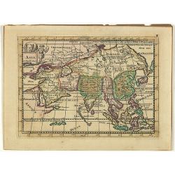
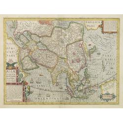
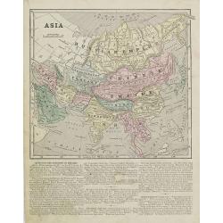
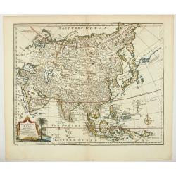
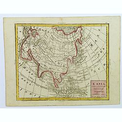
Asia.
Uncommon map of Asia, with a curious shape for Korea. Nice title cartouche in upper left corner with an elephant and a warrior. From his atlas Oorlogs tablessen, Oft uytg...
- $300 / ≈ €281
Place & Date: Amsterdam, 1706
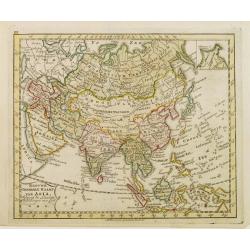
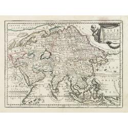
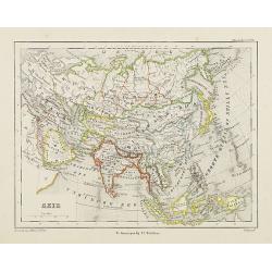
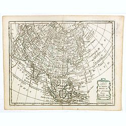
Nieuwe Generale Kaart van Asia.
Uncommon map of Asia, engraved by A.Krevelt. In upper right hand corner inset map of Siberia.
- $120 / ≈ €112
Place & Date: Amsterdam, 1792
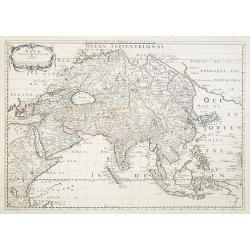
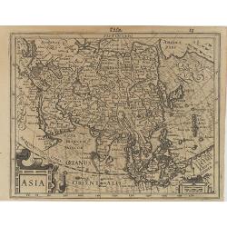
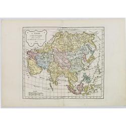
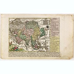
Asie.
Map of Asia still showing Corey as an island. Including Americas West coast.More about Western mapping of Korea maps. [+]
- $500 / ≈ €468
Place & Date: Paris, 1650
![[East coast of Africa, Arabia and west coast of India.]](/uploads/cache/04762-250x250.jpg)
[East coast of Africa, Arabia and west coast of India.]
Rare. Map of the east coast of Africa, Including Madagascar, the Arabian Peninsular, coast of Pakistan and west coast of India.Prepared by Joao Teixeira in 1649, this cha...
Place & Date: Paris, 1664-1696
Encyclopedie des Voyages. Tom 3 ASIE.
There are in this volume as many as 89 color plates, all done by the author himself. Containing dresses of people of China, Persia, Armenia, Philippines, Java, India, Tar...
Place & Date: Paris, 1796

Karte von Asien.
An attractive map of Asia. With a decorative title cartouche in the upper left-hand corner. Engraved by Aarons.Franz Johann Josef von Reilly (Vienna 18 august 1766 - 6 ju...
Place & Date: Vienna 1795
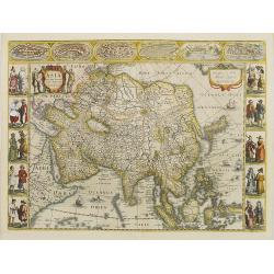
Asiae Nova Descriptio. . .
Several sources appear to have been used in the compilation of this map, including the Portuguese Jesuits Luis Teixeira (1595) for Japan, and Luis Jorgede Barbuda (1584) ...
- $3000 / ≈ €2807
Place & Date: Amsterdam, 1613
L' Asie Dressée Selon les Observations de Mrs. De l' Academie Royale des Sciences..
Delightful little map of Asia that conforms to the standard French model of the period. Hokkaido is attached to the mainland and Terre de Iesso is off the coast partially...
- $300 / ≈ €281
Place & Date: Paris, 1719
Asia.
Map of Asia with an oversized Korea and a curious shape for Japan, from the first French-text edition of Jodocus Hondius' Atlas Minor.Shortly after the publication of the...
Place & Date: Amsterdam, 1608
Asia recens summa cura delineata.
This is the rare early issue with decorative paneled borders. In upper border views and plans of Famagusta, Rhodos, Damascus, Jerusalem, Aden and Ormus. Originally engrav...
Place & Date: Amsterdam, 1632
Asia.
Map of Asia encompassing the Russian Empire, the Chinese Empire, India Persia, Tartary, Turkey, and Arabia. From Sidney E. Morse''s: System of Geography for the use of sc...
Place & Date: New York, 1855
Azie.
Uncommon map of Asia. Lithography by J.H. van Weijer, published in Atlas der geheele Aarde [...] in 24 kaarten.
Place & Date: Groningen, ca. 1860
L'Asie.
Map of Asia. By C. F. Delamarche, successor of Robert de Vaugondy, Geographer.
Place & Date: Paris, 1804
Selling price: $85
Sold in 2016
![[Asia and part of Australia]](/uploads/cache/26453-250x250.jpg)
[Asia and part of Australia]
Engraved map of Asia, with an oversized Japan and part of Australia, called Neu Holland.. Hokaido is called "Sagalien" and the western outlines of "Compagn...
- $400 / ≈ €374
Place & Date: Tübingen, Heerbrandt, 1790
Carte d'Asie.
Fine map of Asia, with an interesting representations of Japan, Hokkaido, Sakhalin Island, Kamchatka and Korea. Engraved by Alexandre Blondeau, who also worked for Depot ...
- $150 / ≈ €140
Place & Date: Paris, c. 1810

Femina indica Orientalis - Indus Africanus - Singava vulgo dicta sive erratica femina Ori.
Beautiful engraving by Abraham de Bruyn showing inhabitants of Asian and African people with captions in Latin, French and German.Abraham de Bruyn, a Flemish engraver and...
Place & Date: Cologne, c.1577
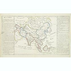
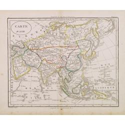
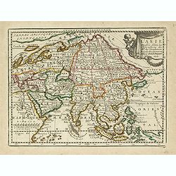
De l'Asie. . .
On the left and on the right two explication cartouche. The text is in French, interesting for its documentation of contemporary European attitudes and preconceptions reg...
- $300 / ≈ €281
Place & Date: Paris, ca. 1767
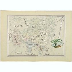
Asie.
Manuscript map made by miss Marie Demeule, dated Elbeuf 1879. Elbeuf is a town within the Upper Normandy region in France.In the 19th century many students, and quite oft...
Place & Date: France, Elbeuf, 1879
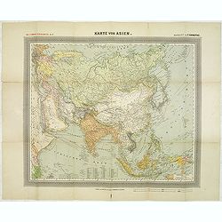
General Karte von Asien. Entworfen und gezeichnet von F. Handtke.
In upper left corner "Carl Flemmings Generalkarten No. / Nr. 37" in a 17th edition. Prepared by Friedrich Handtke (1815-1879). Scale 1: 18.886.000, with a key i...
Place & Date: Glogau, Carl Flemming, c.1910
L' Asie Dressée Selon les Observations de Mrs. De l' Academie Royale des Sciences..
Delightful little map of Asia that conforms to the standard French model of the period. Hokkaido is attached to the mainland and Terre de Iesso is off the coast partially...
- $400 / ≈ €374
Place & Date: Paris, 1719
A new & accurate map of Asia drawn from actual surveys. . .
An excellent early engraving of Asia. Curious shape for Japan, with a large island north called Yeso and a coastline marked De Gamma's Land. Numbered "No 52."; ...
Place & Date: London, 1747
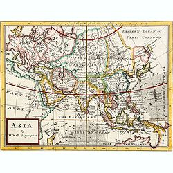
Asia By H.Moll Geographer.
Detailed map of Asia. From his "Atlas minor: or a new and curious set of sixty-two maps. . .", which was first published in 1729 and reprinted in 1732, 1736.The...
Place & Date: London, 1736
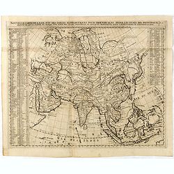
Nouvelle Carte De L'Asie Avec Des Tables Alphabetiques Pour Trouver Sans Peine Les Etats Des Principaux Princes De Cette Partie Du . . .
Chatelain's map of Asia. The title is in two lines across the map. On each side border appears an index to the map's contents.The map is of interest for the use of Mer Or...
Place & Date: Amsterdam, 1719

Asia.
Uncommon map of Asia. Engraved by Marco di Pietro.The map is of interest for the use of G. di Corea, for the sea between Korea and Japan.Published by Carlo Antonio Barbie...
Place & Date: Milan, 1807

L'Asie divisée en ses principaux Etats..
Finely and crisply engraved map of Asia, decorated with an ornamental title cartouche in the lower-left corner. The map is of interest for the use of Mer de Corée for th...
Place & Date: Venice, 1776 - 1784
Carte d'Asie.
Fine map of Asia, with an interesting representations of Japan, Hokkaido, Sakhalin Island, Kamchatka and Korea. Engraved by Alexandre Blondeau, who also worked for Depôt...
- $150 / ≈ €140
Place & Date: Paris, c. 1810
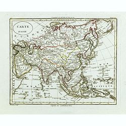
Carte d'Asie.
Fine map of Asia, with an interesting representations of Japan, Hokkaido, Sakhalin Island, Kamchatka and Korea. Engraved by Alexandre Blondeau, who also worked for Depôt...
- $150 / ≈ €140
Place & Date: Paris, c. 1810
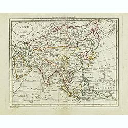
Carte d'Asie.
Fine map of Asia, with an interesting representations of Japan, Hokkaido, Sakhalin Island, Kamchatka and Korea. Engraved by Alexandre Blondeau, who also worked for Depôt...
- $150 / ≈ €140
Place & Date: Paris, c. 1810
![A New and Correct Map of Asia Laid down from the latest and best Observations Humbly Inscribed to his Royal Highness George, Prince of Wales. . . [2 subtitles:] Several Representations of the Customs Manners etc. of Divers Parts of Asia. . .](/uploads/cache/35765-250x250.jpg)
A New and Correct Map of Asia Laid down from the latest and best Observations Humbly Inscribed to his Royal Highness George, Prince of Wales. . . [2 subtitles:] Several Representations of the Customs Manners etc. of Divers Parts of Asia. . .
A large, attractive and rare, separately issued map of Asia with figured side borders. With large decorative title cartouche ad address "By Thomas Kitchin. London, p...
- $5500 / ≈ €5146
Place & Date: London, 1787
A new & accurate map of Asia, Drawn from the most approved modern maps & charts / by Thos. Bowen.
The map is of interest for the use of Sea of Korea for the sea between Korea and Japan.Detailed map of Asia from Saudi Arabia, Persia, Russia, India, China, Japan to Sout...
- $900 / ≈ €842
Place & Date: London, J.Cooke, 1777-1778

Kaartje van Asia. . .
Attractive and rare map of Asia. From Atlas Portatif . With a curious and oversized Hokkaido. The map is of interest for the use of Corease Zee for the sea between Korea ...
Place & Date: Deventer, 1742
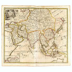
A New Map of Asia from the latest Observations Most Humbly Inscrib'd to the Right Honbl. George Earl of Warrington &c.
Fine map of Asia, with decorative title cartouche flanked by two figures in Asian dress, along with flora and fauna of the continent., based on the work of Guillaume De L...
- $1500 / ≈ €1404
Place & Date: London, 1721
L'Asia...
A small, uncomplicated map of Asia with outline coloring. Map extends down from the Arctic Circle to Java and New Guinea. From Arabia in the west to Japan in the east.Sma...
- $175 / ≈ €164
Place & Date: Venezia, 1810

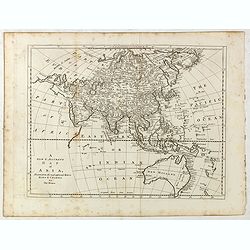
Asia secundum legitimas projectionis stereographicae.
Highlighted area covers part of Spain, eastern coast of Ireland to western part of Papua New Guinea and the Asian continent from the Northern Polar Sea to the Indian Ocea...
Place & Date: Nurenberg, 1744

Kaartje van Asia. . .
Attractive and rare map of Asia. From Atlas Portatif . With a curious and oversized Hokkaido. The map is of interest for the use of Coreanse Zee for the sea between Korea...
Place & Date: Deventer 1742

Oro-Hydrographische Kaart van Azië.
One of the earliest thematic maps of Asia published in the Netherlands from "Atlas der natuurkundige aardrijkskunde. . .". prepared by Nicolaas Wilhelmus Posthu...
- $35 / ≈ €33
Place & Date: Amsterdam, C.L. Brinkman, 1883
Asia verlegt von Ioh Mich Probst.
Uncommon map of Asia, with an explanatory text and directory on the right and the bottom of the map from the "Atlas Minor ex Tabulis Geographicis ".The map is o...
- $300 / ≈ €281
Place & Date: Augsburg, 1789
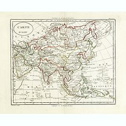
Carte d'Asie . . .
Map of the Asian continent, from Atlas moderne portatif composé de vingt-huit cartes sur toutes les parties du globe terrestre .. A l'usage des Colléges, des Pensions &...
- $230 / ≈ €215
Place & Date: Paris, Prudhomme, Levrault, Debray, 1806
II Pars Indiae Orientalis in qua Johan. Hugonis Linschotani. . .
De Bry's Part II of his "Les Petit Voyages", containing "Pars Indiae Orientalis, in qua Johan. Hugonis Linscotani navagatio in Orientem, 1609", being ...
Place & Date: Frankfurt, Wolffgang Richter, 1609
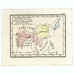
Missions en Asie Contenant les Provinces Françaises de la Chine et des Indes avec le Malabar Province des Portuguais. 7 Jésuits a la Chine et 57 au Japon.
Rare map of Far East from India until Japan from "Atlas Universel indiquant les établissemens des Jésuites: avec la manière dont ils divisent la terre, suivi des�...
- $200 / ≈ €187
Place & Date: Paris, Ambroise Dupont , 1826