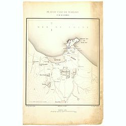
Browse Listings in Asia > China > China Provinces
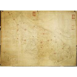
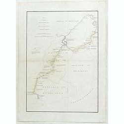
Militairy manuscript map of the end of Yangzi River across Shanghai, Jiangsu, and Zhejiang areas, with 3 red seals of the Ever-Victorious Army.
In lower left corner an inset plan of Songjiang District with Shanghai with a grid and the area is divided with red doted border lines.The map has three red seals of the ...
Place & Date: China, ca 1862
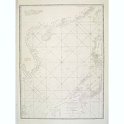
A chart of the China Sea inscribed to Monsr. D'APRES de MANNEVILLETTE .. To A.Dalrymple.
Most important milestone sea chart is based upon the surveys made from navigational surveys by Alexander Dalrymple (1737-1808]. He was the first Hydrographer of the Briti...
Place & Date: Paris, ca. 1775
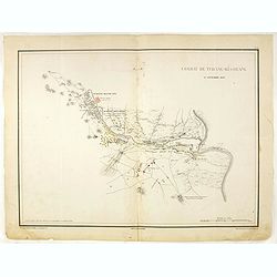
Combat de Tchang-Ki-Ouang 18 septembre 1860.
Plate VI from "Atlas de l'expédition de Chine en 1860: rédigé au dépôt de la guerre d'après les documents officiels, étant directeur le général Blondel, sou...
Place & Date: Paris, 1862

China Southeast Coast.
A very large US Army and Naval map of the south east coast of China, published during the second world war. Map extent is from Kweichow Province in the west, to Kwangsi P...
- $1250 / ≈ €1170
Place & Date: [New York], 1944
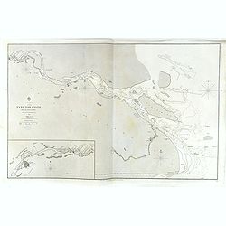
China, Sheet IX, Yang-Tse-Kiang from the sea to Nanking . . .
A fine, large-scale chart. This chart depicts the last stretch of the Yangtse River before it meets the sea. It gives soundings and notes on the tides, and includes an in...
- $750 / ≈ €702
Place & Date: London, 1843-1859
Plan de Camp de Tché-Fou et de ses environs.
A rare and detailed plan of Chefoo, which was a treaty port in Shantung province, near today's Yantai. Plate IV from "Atlas de l'expédition de Chine en 1860: rédig...
- $300 / ≈ €281
Place & Date: Paris, 1862
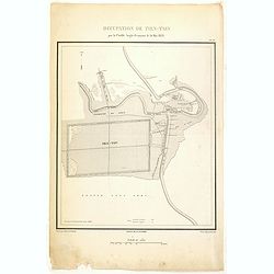
Occupation de Tien-Tsin par la Flottille Anglo-Française le 26 Mai 1859.
Plate III from "Atlas de l'expédition de Chine en 1860: rédigé au dépôt de la guerre d'après les documents officiels, étant directeur le général Blondel, so...
- $250 / ≈ €234
Place & Date: Paris, 1862
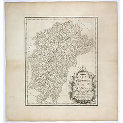
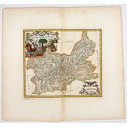
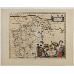
Province de Kiang-Si. Jiangxi 江西 province.
An important map of Jiangxi 江西 province. With a quite elaborately pictorial cartouche featuring a rococo chinoiserie ornamentation, engraved by Guélard. The map itse...
- $200 / ≈ €187
Place & Date: Paris, P.G. Le Mercier, 1735
![Province de Koei-Tcheou. [Koei-tcheou 贵州 [Guizhou] province.]](/uploads/cache/39688-250x250.jpg)
Province de Koei-Tcheou. [Koei-tcheou 贵州 [Guizhou] province.]
Important map of Koei-tcheou 贵州 [Guizhou]. With a quite elaborately pictorial cartouche featuring a rococo chinoiserie ornamentation, engraved by Guélard, the map by...
- $300 / ≈ €281
Place & Date: Paris, P.G. Le Mercier, 1735
![Province de Pe-Tche-Li. Pe-tche-li [Beizhili] 北直隶 [= 河北]. province.]](/uploads/cache/39689-250x250.jpg)
Province de Pe-Tche-Li. Pe-tche-li [Beizhili] 北直隶 [= 河北]. province.]
Important map of Pe-tche-li [Beizhili] 北直隶 [= 河北]. With a quite elaborately pictorial cartouche featuring a rococo chinoiserie ornamentation, engraved by Guéla...
- $300 / ≈ €281
Place & Date: Paris, P.G. Le Mercier, 1735
![Province de Tche Kiang. [Tche kiang 浙江 [Zhejiang] province]](/uploads/cache/39693-250x250.jpg)
Province de Tche Kiang. [Tche kiang 浙江 [Zhejiang] province]
D'Anville's highly detailed map of Tche kiang 浙江 [Zhejiang] province from du Halde's "Description geographique historique...de l'Empire de la Chine et de la Tart...
- $400 / ≈ €374
Place & Date: Paris, P.G. Le Mercier, 1735
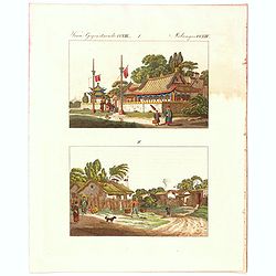
Verm Gegenstaende. CXIII. 1 Melandes CCXIII.
A Chinese Mandarin house and below a Chinese village scene with farmers.
- $50 / ≈ €47
Place & Date: Germany, 1812
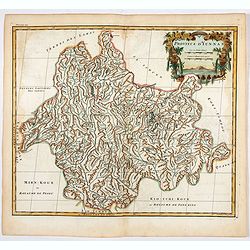
![Province de Hou-Quang. [Hou-quang 湖广 [Huguang] province.]](/uploads/cache/39694-250x250.jpg)
Province de Hou-Quang. [Hou-quang 湖广 [Huguang] province.]
Important map of Hou-quang 湖广 [Huguang] province. With a quite elaborately pictorial cartouche, engraved by Guélard, the map engraved by F.Baillieul Lainé, featurin...
- $250 / ≈ €234
Place & Date: Paris, P.G. Le Mercier, 1735
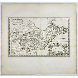
Province de Chan-Tong.
Detailed map of Shandong Province. With a quite elaborately pictorial cartouche, engraved by Guélard, the map by Delahaye, featuring a rabbit and rococo chinoiserie orna...
- $300 / ≈ €281
Place & Date: Paris, P.G. Le Mercier, 1735
![Province de Chan-Si. [Chan-s 山西i [Shanxi] province. ]](/uploads/cache/39697-250x250.jpg)
Province de Chan-Si. [Chan-s 山西i [Shanxi] province. ]
An important map of Chan-s 山西i [Shanxi] province. With a quite elaborately pictorial cartouche, engraved by Guélard, the map by Delahaye. Jean Baptiste Bourguignon d...
- $200 / ≈ €187
Place & Date: Paris, P.G. Le Mercier, 1735
![Province de Se-Tchuen. [ Se-tchuen 四川 [Sichuan] province.]](/uploads/cache/39699-250x250.jpg)
Province de Se-Tchuen. [ Se-tchuen 四川 [Sichuan] province.]
Important map of Se-tchuen 四川 [Sichuan] province. With a quite elaborately pictorial cartouche, engraved by Guélard, the map by Delahaye, features animals, birds, a ...
- $450 / ≈ €421
Place & Date: Paris, P.G. Le Mercier, 1735
![Province de Ho-nan. [Honan 河南 (Hénán) province]](/uploads/cache/39696-250x250.jpg)
Province de Ho-nan. [Honan 河南 (Hénán) province]
An important map of Honan 河南 (Hénán) province. With a quite elaborately pictorial cartouche, engraved by F.Baillieul Lainé. Jean Baptiste Bourguignon d' Anville (1...
- $200 / ≈ €187
Place & Date: Paris, P.G. Le Mercier, 1735
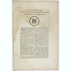
Carte du ciel et de la terre qui commencent à se former / Figure du ciel fluide & pur & de la terre fixe & ferme.
Recto and verso text page with two illustrations of the grounding of the sky and earth according to a Chinese philosopher. Jean Baptiste Bourguignon d' Anville (1697-178...
- $75 / ≈ €70
Place & Date: Paris, P.G. Le Mercier, 1735
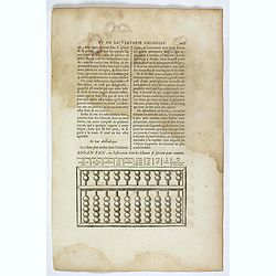
Souan pan, ou instrument dont les chinois se servent pour compter.
Text page with a wood block illustration of a souan-pan [suan-p'an] the calculation table used by the Chinese. Jean Baptiste Bourguignon d' Anville (1697-1782), French c...
- $20 / ≈ €19
Place & Date: Paris, P.G. Le Mercier, 1735
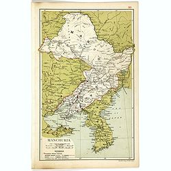
Manchuria.
Map of Manchuria and Korea. With in lower left corner scales in miles and kilometers, Protestant Mission Stations, railways both opened and in progress, canals and telegr...
- $75 / ≈ €70
Place & Date: London, 1910
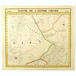
Partie de L'Empire Chinois - No.47.
One of Vandermaelen's 378 conjoined maps on a uniform scale to made up the total globe. This map features the Eastern Mongolia portion of China with Oloa Baytin. Interest...
- $75 / ≈ €70
Place & Date: Brussels, 1825-1827
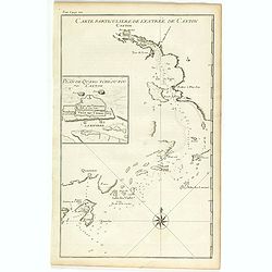
Carte particulière de l'entrée de Canton - Plan de Quang-tcheou-fou vulgo Canton .
Beautiful detailed map of the entrance to the city of Canton, showing also the cities of Macao and Quanghai, as well as the islands of the bay, including the island of Sh...
- $450 / ≈ €421
Place & Date: Paris, P.G. Le Mercier, 1735
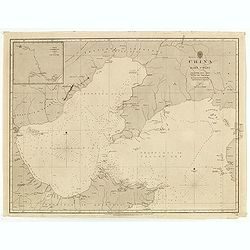
China east coast Yellow Sea and Gulf of Pechili
Very detailed chart of China's east coast with the Yellow Sea and Gulf of Pechili. Scale: circa 1:1m. Inscription: J & C Walker sculpt. One inset: Pekin to the Gulf o...
- $450 / ≈ €421
Place & Date: London, 1840 - 1859
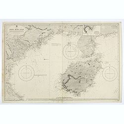
China sea. Tong King Gulf Compiled from the latest British and Foreign Government surveys to 1886. . .
Detailed Map of Chart of Annam Gulf or Tong King Gulf, in the China Sea. Chart with legend and scale. British Admiralty chart No. 2062, published June 1881, large correct...
- $400 / ≈ €374
Place & Date: London, 1881 updated to 1957
![Carte de la province de Tche kiang 浙江 [Zhejiang]](/uploads/cache/30923-250x250.jpg)
Carte de la province de Tche kiang 浙江 [Zhejiang]
D'Anville's highly detailed map of Tche Kiang (Zhejiang) province from du Halde's "Description geographique historique...de l'Empire de la Chine et de la Tartarie Ch...
- $250 / ≈ €234
Place & Date: Paris, P.G. Le Mercier, 1735
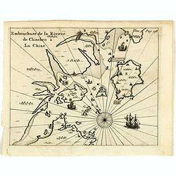
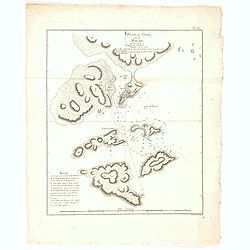
Embouchure de la rivière de Chincheo à la Chine.
This map is a view of Quanzhou Bay. Quanzhou was established in 718 during the Tang Dynasty (618–907). In those days, Guangzhou was China's greatest seaport, but this s...
Place & Date: Amsterdam, F. Bernard, 1725
Selling price: $110
Sold in 2014
Xantung, e Peking provincie della china. . .
A beautiful map depicting the area of Beijing with decorative title cartouche and scale cartouche. Information about the area at the top of the map.To the right the west ...
- $350 / ≈ €328
Place & Date: Venice, 1698
Boucle du Pei-Ho.
Manuscript map of Boucle du Pei-Ho (Taku Forts) showing the river Pei-ho, along with the projected railway lines were to be built, including bridges, installations, villa...
- $750 / ≈ €702
Place & Date: China ?, ca.1910
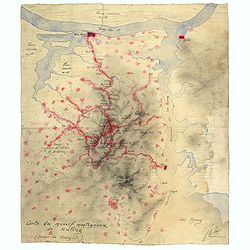
Carte du massif montagneux de Kuling (Province de Kiand-Si).
Manuscript map of the Kuling mountain range, showing the YangTze River, Lake Poyang, villages, etc. in French. Signed J.Volaz (?).Guling (or Kuling), is a resort town in ...
- $1500 / ≈ €1404
Place & Date: China ?, ca.1930
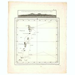
Plan du Typa, ou de Macao.
A pleasant copper engraving of Typa, Macao. By Rigobert Bonne from his ATLAS ENCYCLOPEDIQUE published in 1780. Engraved by Andre.Rigobert Bonne (1727-1795) was one of the...
- $100 / ≈ €94
Place & Date: Paris, 1780
Vue de la Côte du Japon lorsque nous la vimespour la 1ere fois La Coline A restant dans l'O à 3 Millerc.
A pleasant copper engraving of Japan coasts. By Rigobert Bonne from his ATLAS ENCYCLOPEDIQUE published in 1780. Engraved by Andre.Rigobert Bonne (1727-1795) was one of th...
- $100 / ≈ €94
Place & Date: Paris, 1780
Province de Koei-Tcheou.
An important map of Koei-tcheou 贵州 [Guizhou]. With a quite elaborately pictorial cartouche featuring a rococo chinoiserie ornamentation engraved by Guélard, the map ...
- $100 / ≈ €94
Place & Date: Paris, P.G. Le Mercier, 1735
Province d'Yun-Nan.
Important map of Yun-nan 云南 [Yunnan] province. With a quite elaborately pictorial cartouche featuring a rococo chinoiserie ornamentation, engraved by Delahaye. Jean B...
- $75 / ≈ €70
Place & Date: Paris, P.G. Le Mercier, 1735
Sketch of A Journey from Hang-Tchoo-Foo To Quang-Tchoo-Foo or Canton in China.
A detailed map taken from, from Staunton's 'An Authentic Account of an Embassy from the King of Great Britain to the Emperor of China'.The map shows the second part of Ma...
Place & Date: London, 1796
Pecheli sive Peking imperii sinarum provincia prima.
The map of the province of Peking from Joan Blaeu's Novus Atlas Sinensis , the first atlas of China with maps by the hand of the Italian Jesuit Martino Martini. A beautif...
Place & Date: Amsterdam, 1640
![[Lot of 6] Carte de la Baye d'Hocsieu. Fukin. (3 Maps + 3 Gravure of China)](/uploads/cache/IMG_2524-250x250.jpg)
[Lot of 6] Carte de la Baye d'Hocsieu. Fukin. (3 Maps + 3 Gravure of China)
[Lot of 6 items]. (3 Maps +3 gravure )- Carte de la Baye d'Hocsieu et des Entrees de la Riviere de Chang Situees dans la Province de Fokyen. J.N.Berlin 1748- Carte de l�...
Place & Date: Amsterdam, 1759

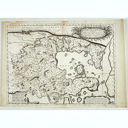
Iunan, Queichev, e Quangsi Provincie della Cina. . .
A beautiful map depicting the area of Beijing with decorative title cartouche and scale cartouche. Information about the area at the top of the map.The remarkable Vincenz...
Place & Date: Venice, 1690

Huquang, Kiangsi, Chekiang ac Fokien.
A reissue of Janssonius' map of south east China, with wash color and uncolored cartouches.The map is based on the maps of Martin Martini, themselves based on Chinese sou...
Place & Date: Amsterdam, 1720

A chart of the China Sea inscribed to Monsr. D'APRES de MANNEVILLETTE .. To A.Dalrymple.
Most important milestone chart is based upon the surveys made from navigational surveys by Alexander Dalrymple (1737-1808]. He was the first hydrographer of the British A...
Place & Date: Paris, ca 1775

Reis-kaart van het Britsche gezantschap van Hang-choe-foe naar Quang-choe-foe of Kanton in China.
Uncommon map of eastern part of China, showing a journey of the English Embassy from Hangzhou (south of Shanghai) to Guangzhou (Canton). The maps is giving a wealth of in...
Place & Date: Netherlands, c.1800

Xantung, sinarum imperii provincia quatra.
A map of the northern province ‘Xantung’ of China after the Jesuit Martino Martini.Shows the Great Wall and is centered on the Bohai Sea, and the Shandong and Liaonin...
Place & Date: Amsterdam, ca 1660
![Nankin [Nanjing, Jiangsu]](/uploads/cache/30031-250x250.jpg)
Nankin [Nanjing, Jiangsu]
Very detailed (1:1.000.000) map showing the area north of Nanjing, Jiangsu. The French Service géographique des armées was founded in 1887 and provided the French milit...
Place & Date: Paris, 1900

Carte du Kouy-Tchéou.
Detailed map of Guizhou Province prepared by Mgr. Faurie and other sources supplied by missionaries. Published in "Les Missions Catholique". Engraved by P. Méa...
Place & Date: Lyon, c.1874
![Carte du Tche-Kiang. [ Zhejiang province ]](/uploads/cache/30921-250x250.jpg)
Carte du Tche-Kiang. [ Zhejiang province ]
Map of Tche Kiang, prepared by Bishop Edmond-François Guierry, C.M. (Vicar Apostolic of Zhejiang, China) after sources supplied by missionaries. Published in "Les M...
Place & Date: Paris, 1874

Pecheli, Xansi, Xantung, Honan, Nanking, In plaga Regni Sinensis. . .
A map of the northern provinces of China after the Jesuit Martino Martini, depicting of Hebei (Pecheli), Shanxi (Xansi), Shandong (Xantung), Henan (Honan), and Jangsu (Na...
Place & Date: Amsterdam, ca 1660
![Carte de la coste orientale de la Chine depuis Amoy, jusqu'à Chusan avec une partie de l'Isle Formose [with] Plan du port d'Amoy ou Emouy.](/uploads/cache/33583-250x250.jpg)
Carte de la coste orientale de la Chine depuis Amoy, jusqu'à Chusan avec une partie de l'Isle Formose [with] Plan du port d'Amoy ou Emouy.
Important French chart of the China Sea with the coast of Northern China, including a large depiction of Formosa.Latitude and longitude scales, compass rose and system of...
Place & Date: Paris, Jean-François Robustel, 1745

Partie de la Chine. N°.74 (Including South Korea)
Covering the Mouth of the Yangtze area in Jiangsu and Zhejiang, and southwestern Korea with the island of Quelpart (Jeju-do). Shows explorers' routes, including La Perou...
Place & Date: Brussels, 1825-1827

Partie de la Chine N°87. (Covers Jiangxi, Fujian and parts of Zhejiang, Guangdong, Hunan and Hubei.)
Covers Jiangxi, Fujian and parts of Zhejiang, Guangdong, Hunan and Hubei.From his famous Atlas Universel . This atlas was one of the most remarkable world atlases ever pr...
Place & Date: Brussels, 1825-1827

Partie de la Chine N°86. (Covers Guizhou and parts of Yunnan, Guangxi, Hunan, Hubei and Sichuan.)
Covers Guizhou and parts of Yunnan, Guangxi, Hunan, Hubei and Sichuan.From his famous Atlas Universel . This atlas was one of the most remarkable world atlases ever produ...
Place & Date: Brussels, 1825-1827
![[India and China]](/uploads/cache/33875-250x250.jpg)
[India and China]
Wood block printed map and one of earliest printed representation of India and China prepared Martin Waldseemüller. Based on the slightly larger map from 1513 published ...
Place & Date: Vienna, 1525 -1541

Xantung, sinarum imperii provincia quatra.
A map of the northern province ‘Xantung’ of China after the Jesuit Martino Martini.Shows the Great Wall and is centered on the Bohai Sea, and the Shandong and Liaonin...
Place & Date: Amsterdam, ca 1660

Fokien Imperii Sinarum Provincia undecima.
The province of Fokien lies opposite Taiwan and south of the region described in the above map. The coast is shown from Wen-zhou in the north to Fu-zhou and as far south ...
Place & Date: Amsterdam, 1660