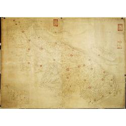
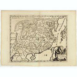
Militairy manuscript map of the end of Yangzi River across Shanghai, Jiangsu, and Zhejiang areas, with 3 red seals of the Ever-Victorious Army.
In lower left corner an inset plan of Songjiang District with Shanghai with a grid and the area is divided with red doted border lines.The map has three red seals of the ...
Place & Date: China, ca 1862
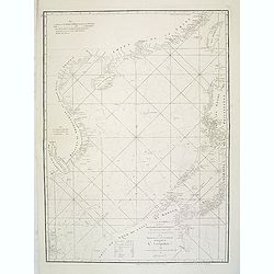
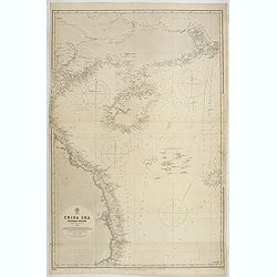
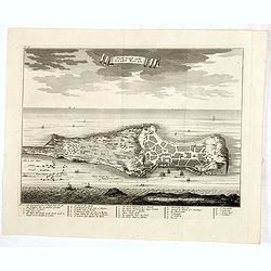
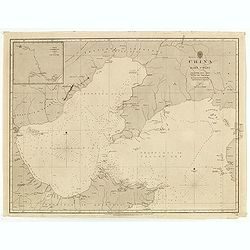
A chart of the China Sea inscribed to Monsr. D'APRES de MANNEVILLETTE .. To A.Dalrymple.
Most important milestone sea chart is based upon the surveys made from navigational surveys by Alexander Dalrymple (1737-1808]. He was the first Hydrographer of the Briti...
Place & Date: Paris, ca. 1775
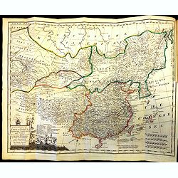
The Modern History, by way of sequel to Mr. Rollin's ancient history. Vol. I. Containing the history of China.
A rare book translated from French and printed for J.& P. Knapton. The volume is divided into a number of parts, covering a general history of China, a description of...
Place & Date: London, 1704
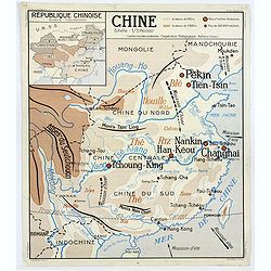
Chine - Angleterre.
A large, vintage French school poster map from the 1950s, showing China on one side and the United Kingdom on the reverse. As you would expect content and detail and basi...
Place & Date: Nalliers, ca 1955
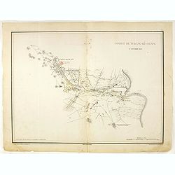
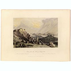
Combat de Tchang-Ki-Ouang 18 septembre 1860.
Plate VI from "Atlas de l'expédition de Chine en 1860: rédigé au dépôt de la guerre d'après les documents officiels, étant directeur le général Blondel, sou...
Place & Date: Paris, 1862
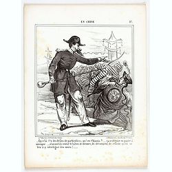
En Chine.
From the series "Caricatures du Prussien - Guerre des Duchés". Lithographed by Julés Pelcoq.
Place & Date: Paris, 1864
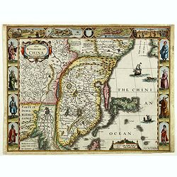
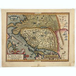
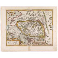
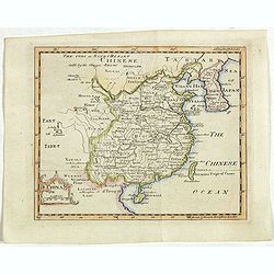
The Kingdome of China.
A most sought-after map of China. Decorative border vignettes including views of the cities of Quinzay and Macao along the top border with the wheeled wind machines and p...
Place & Date: London, G. Humble, 1626
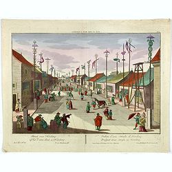
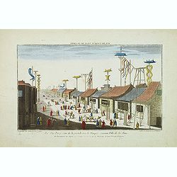
Vue d'une Rue Nanking.
A well-known publisher of optical prints, established in Augsburg. After a design by P.van Blankaert.In the eighteenth and nineteenth centuries, there were many popular s...
Place & Date: Augsburg 1760

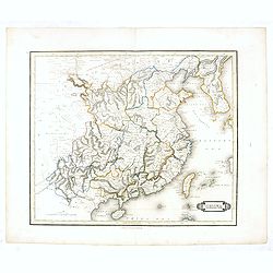
China Southeast Coast.
A very large US Army and Naval map of the south east coast of China, published during the second world war. Map extent is from Kweichow Province in the west, to Kwangsi P...
- $1250 / ≈ €1170
Place & Date: [New York], 1944

Paradigma XV Provinciarum et CLV Urbium Capitalium Sinensis Imperij Cum Templis quae Cruce X Signatur Et Domiciliis S.I.
First edition of this rare Jesuit map of China, published by Jean Baptiste Nolin in Paris and based on Philippe Couplet's map of 1686. The map shows China's 15 provinces ...
- $2400 / ≈ €2246
Place & Date: Paris, 1686
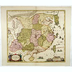
Chinae, olim Sinarum Regionis, nova descriptio. Auctore Ludovico Georgio.
The first map of China ever to appear in a Western atlas, west to the top. When this map appeared, it was by far the most accurate one of China.The map is based on a manu...
- $5500 / ≈ €5146
Place & Date: Antwerp, 1608 /1612
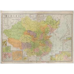
New China Map.
Very large and detailed map of China (1:6,000,000) printed in Shanghai, June 27th 1938 by JIN-SHIN GEOGRAPHICAL INSTITUTE.The title and place names in Chinese and Engli...
- $900 / ≈ €842
Place & Date: Shanghai, June 27th 1938
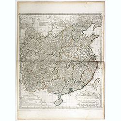
Carte Generale de la Chine Dressée sur les Cartes Particulieres Que l' Empereur Chang-Hi a fait lever sur les lieux. . . .
With a quite elaborately pictorial cartouche, engraved by the master engraver Guillaume-Nicolas de la Haye (1727 -1802). Large map showing the traditional limits of China...
- $750 / ≈ €702
Place & Date: Paris, Dezauche, 1789–1799
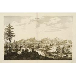
Peking.
Fine panoramic view of Peking. From Olfert Dapper mission to China, 1662-1663. Printed by Jacob van Meurs, title of the book: Gedenckwaerdig bedrijf der Nederlandsche Oos...
- $200 / ≈ €187
Place & Date: Amsterdam, 1670
![Wusung River or Hwang Pu. / Wusung River Entrance [With Shanhhai]](/uploads/cache/48595-250x250.jpg)
Wusung River or Hwang Pu. / Wusung River Entrance [With Shanhhai]
A fine Survey chart no. 1601 showing Wusung River or Hwang Pu. / Wusung River Entrance [With Shanghai]
- $800 / ≈ €749
Place & Date: London, 1887 - 190, updated to 1903
China Sea Nothern Porton compiled from the latest survey to 1884
A fine Survey chart no. 2680 showing Tong King Gulf, Hanan Island up to Hong Kong, Macao and Canto River up to Canton (Being)
- $800 / ≈ €749
Place & Date: London, 1887, updated to 1897
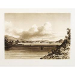
Macao.
Early view of Macao after Barthelemy Lauvergne (1805-1875) and engraved in aquatint technique by Sigismond Himely (1801-1872). Published as plate 28 in Voyage autour du m...
- $600 / ≈ €561
Place & Date: Paris, Finot, 1835
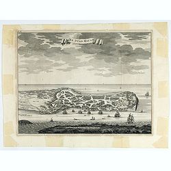
De Stad Macao.
A fine view of the city of Macao from Lappa Island showing the defenses, the forts, churches and convents: including Fort de Baare, Bon Parto, Fort St Paulo (Monte Fort)....
- $750 / ≈ €702
Place & Date: Amsterdam, 1724
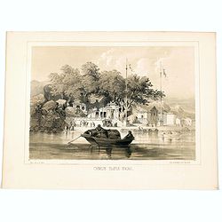
Chinese Temple, Macao.
A pleasant view of the important Chinese Temple in Macao, taken from the water with a junk in the foreground and many sampans and junks moored in front of it, with visito...
- $75 / ≈ €70
Place & Date: Philadelphia, 1856
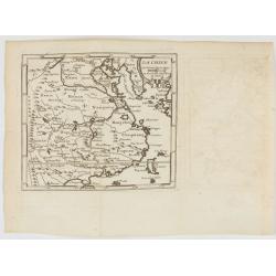
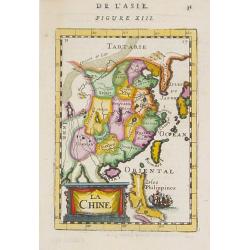
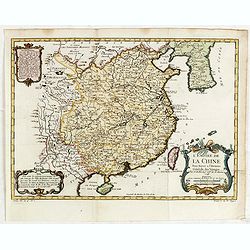
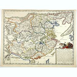
La Chine.
With decorative title cartouche lower right. Good detail of China's mainland with Taiwan and Hainan Province.
- $300 / ≈ €281
Place & Date: Paris, 1767
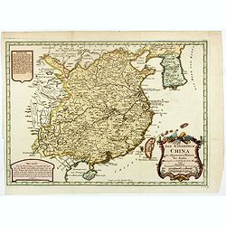
La Chine.
A very nice map of China, including Korea and Taiwan. From Francisco Giustiniani for El Atlas abreviado o el nuevo compendio de la Geografia universal, politica, historic...
- $300 / ≈ €281
Place & Date: Leon de Francia (Lyon), Jaime Certa, 1739
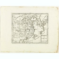
La China e Giapone.
Rare map of China, Korea and Japan, from "Atlante Novissimo ad uso Dei Giovani Studiosi Contenuto In Carte XXVII.", published by Giovanni Zempel in Rome, ca. 17...
- $300 / ≈ €281
Place & Date: Rome, 1780

La Chine.
Rare map of China, Korea (as an island) and Japan, published by Jollain in 1667. In upper right corner part of North America. Published in "Trésor Des Cartes Geogra...
- $350 / ≈ €328
Place & Date: Paris, 1667
Attaque & prise des forts du Pei-Ho Le 21 Août 1860, par les troupes Françaises et Anglaises.
In 1860, an Anglo-French force gathered at Hong Kong and then carried out a landing at Pei Tang on August 1, and a successful assault on the Taku Forts on August 21.This ...
- $500 / ≈ €468
Place & Date: Paris, ca.1865
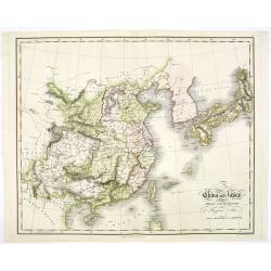
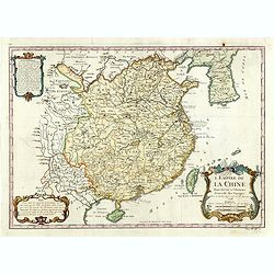
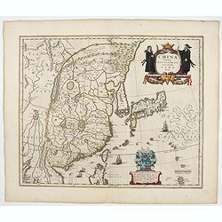
Imperii Sinarum nova descriptio.
Schenk and Valk's rare early 18th century issue of Janssonius milestone map of China, Korea and Japan after Martino Martini. Engraved by Johannes van Loon. The overall ba...
- $1600 / ≈ €1497
Place & Date: Amsterdam, ca. 1660
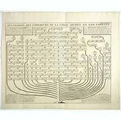
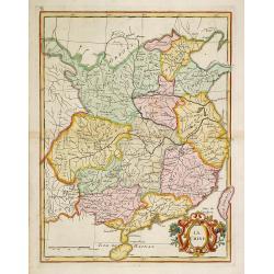
Succession Des Empereurs De la Chine divisée en XXII. Familles.
Showing successions of the Emperors of China divided into 22 families, copper engraved plate from "Atlas Historique". Zacharie Chatelain (d.1723) was the father...
- $100 / ≈ €94
Place & Date: Amsterdam, 1720
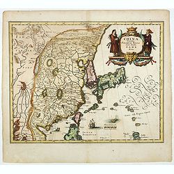
China Veteribus Sinarum Regio nunc Incolis Tame dicta.
Fine map of China, based on the first of Blaeu's maps of China. In the west by the Great Wall is shown, among Taiwan is named Pakan al I. Formosa, although Tayoan is name...
- $950 / ≈ €889
Place & Date: Frankfurt am Main, 1638
La Chine.
A charming small map of China, Taiwan, Philippines, Korea and Kyushu (Japan). By Allain Manneson Mallet (1630-1706), a well traveled military engineer and geographer who ...
- $300 / ≈ €281
Place & Date: Paris, 1720
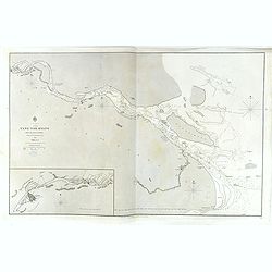
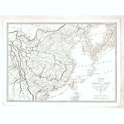
China, Sheet IX, Yang-Tse-Kiang from the sea to Nanking . . .
A fine, large-scale chart. This chart depicts the last stretch of the Yangtse River before it meets the sea. It gives soundings and notes on the tides, and includes an in...
- $750 / ≈ €702
Place & Date: London, 1843-1859
L'Empire de la Chine. . .
A fine map of China, Korea and Taiwan.Jacques Nicholas Bellin (1703-1772) was one of the most important and proficient French cartographers of the mid-eighteenth century....
- $450 / ≈ €421
Place & Date: Paris, 1748
Das Kaiserthum China zur allgemeinen Historie der Reisen - entworfen von N. Bellin Ing. De la Mar. 1748.
Attractive and detailed map of China and Korea. The map is of interest for the use of Das Meer von Korea for the coast along the east coast of Korea. The composition is n...
- $500 / ≈ €468
Place & Date: Leipzig, Arkstee & Merkus, 1746
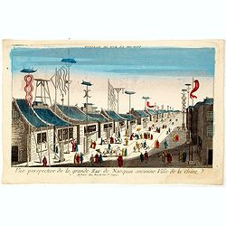
Vue perspective de la grande Rue de Nanquin ancienne Ville de la Chine.
So-called optical print of a street in Nanking. The wide boulevard is lined with merchants displaying their wares with colorful flags and signs. The street is filled with...
- $600 / ≈ €561
Place & Date: Paris, c.1780
Imperii Sinarum Nova Descriptio.
Interesting map of China, shows the Great Wall, Macao and the Island of Formosa. From Philipp Clüver's famous Introductionis in Universam geographicam, first published i...
- $300 / ≈ €281
Place & Date: Amsterdam, 1697
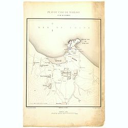
Occupation de Tien-Tsin par la Flottille Anglo-Française le 26 Mai 1859.
Plate III from "Atlas de l'expédition de Chine en 1860: rédigé au dépôt de la guerre d'après les documents officiels, étant directeur le général Blondel, so...
- $250 / ≈ €234
Place & Date: Paris, 1862
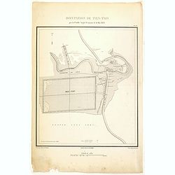
Plan de Camp de Tché-Fou et de ses environs.
A rare and detailed plan of Chefoo, which was a treaty port in Shantung province, near today's Yantai. Plate IV from "Atlas de l'expédition de Chine en 1860: rédig...
- $300 / ≈ €281
Place & Date: Paris, 1862
![[View of Castle and Bridge Vandipore - Bhutan - Tibet ]](/uploads/cache/34997-250x250.jpg)
[View of Castle and Bridge Vandipore - Bhutan - Tibet ]
Aquatint print with view of Castle and Bridge Vandipore - Bhutan - Tibet engraved by G. Castellini. Plate N°7.From Giulio Ferrario's work Le Costume Ancien et Moderne ou...
- $75 / ≈ €70
Place & Date: Milan, 1827
Charte von China nach Murdochischer Projection entworfen. ... Berichtiget, und gezeichnet von H.F.A. Stieler. . .
Uncommon map of China prepared by H.F.A.Stieler, with parts of Taiwan, Tibet, Mongolia and the Korean peninsula, with a great many place names, a key to (and brief explan...
- $600 / ≈ €561
Place & Date: Weimar, 1804
China and Japan drawn and engraved for Dr. Playfairs Atlas.
Detailed map of China, Korea, Japan and Taiwan engraved by H. Cooper and published by Alexander Macredie. Originally engraved for James Playfair's " A New General At...
- $900 / ≈ €842
Place & Date: Edinburgh, 1824
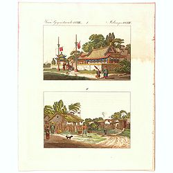
Verm Gegenstaende. CXIII. 1 Melandes CCXIII.
A Chinese Mandarin house and below a Chinese village scene with farmers.
- $50 / ≈ €47
Place & Date: Germany, 1812
![Province de Ho-nan. [Honan 河南 (Hénán) province]](/uploads/cache/39696-250x250.jpg)
Province de Ho-nan. [Honan 河南 (Hénán) province]
An important map of Honan 河南 (Hénán) province. With a quite elaborately pictorial cartouche, engraved by F.Baillieul Lainé. Jean Baptiste Bourguignon d' Anville (1...
- $200 / ≈ €187
Place & Date: Paris, P.G. Le Mercier, 1735
![Province de Se-Tchuen. [ Se-tchuen 四川 [Sichuan] province.]](/uploads/cache/39699-250x250.jpg)
Province de Se-Tchuen. [ Se-tchuen 四川 [Sichuan] province.]
Important map of Se-tchuen 四川 [Sichuan] province. With a quite elaborately pictorial cartouche, engraved by Guélard, the map by Delahaye, features animals, birds, a ...
- $450 / ≈ €421
Place & Date: Paris, P.G. Le Mercier, 1735
![Province de Chan-Si. [Chan-s 山西i [Shanxi] province. ]](/uploads/cache/39697-250x250.jpg)
Province de Chan-Si. [Chan-s 山西i [Shanxi] province. ]
An important map of Chan-s 山西i [Shanxi] province. With a quite elaborately pictorial cartouche, engraved by Guélard, the map by Delahaye. Jean Baptiste Bourguignon d...
- $200 / ≈ €187
Place & Date: Paris, P.G. Le Mercier, 1735
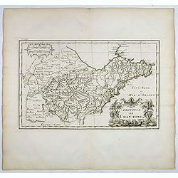
Province de Chan-Tong.
Detailed map of Shandong Province. With a quite elaborately pictorial cartouche, engraved by Guélard, the map by Delahaye, featuring a rabbit and rococo chinoiserie orna...
- $300 / ≈ €281
Place & Date: Paris, P.G. Le Mercier, 1735
![Province de Hou-Quang. [Hou-quang 湖广 [Huguang] province.]](/uploads/cache/39694-250x250.jpg)
Province de Hou-Quang. [Hou-quang 湖广 [Huguang] province.]
Important map of Hou-quang 湖广 [Huguang] province. With a quite elaborately pictorial cartouche, engraved by Guélard, the map engraved by F.Baillieul Lainé, featurin...
- $250 / ≈ €234
Place & Date: Paris, P.G. Le Mercier, 1735
![Province de Tche Kiang. [Tche kiang 浙江 [Zhejiang] province]](/uploads/cache/39693-250x250.jpg)
Province de Tche Kiang. [Tche kiang 浙江 [Zhejiang] province]
D'Anville's highly detailed map of Tche kiang 浙江 [Zhejiang] province from du Halde's "Description geographique historique...de l'Empire de la Chine et de la Tart...
- $400 / ≈ €374
Place & Date: Paris, P.G. Le Mercier, 1735
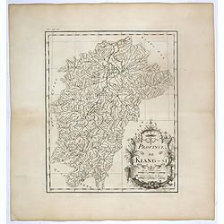
Province de Kiang-Si. Jiangxi 江西 province.
An important map of Jiangxi 江西 province. With a quite elaborately pictorial cartouche featuring a rococo chinoiserie ornamentation, engraved by Guélard. The map itse...
- $200 / ≈ €187
Place & Date: Paris, P.G. Le Mercier, 1735
![Province de Pe-Tche-Li. Pe-tche-li [Beizhili] 北直隶 [= 河北]. province.]](/uploads/cache/39689-250x250.jpg)
Province de Pe-Tche-Li. Pe-tche-li [Beizhili] 北直隶 [= 河北]. province.]
Important map of Pe-tche-li [Beizhili] 北直隶 [= 河北]. With a quite elaborately pictorial cartouche featuring a rococo chinoiserie ornamentation, engraved by Guéla...
- $300 / ≈ €281
Place & Date: Paris, P.G. Le Mercier, 1735
![Province de Koei-Tcheou. [Koei-tcheou 贵州 [Guizhou] province.]](/uploads/cache/39688-250x250.jpg)
Province de Koei-Tcheou. [Koei-tcheou 贵州 [Guizhou] province.]
Important map of Koei-tcheou 贵州 [Guizhou]. With a quite elaborately pictorial cartouche featuring a rococo chinoiserie ornamentation, engraved by Guélard, the map by...
- $300 / ≈ €281
Place & Date: Paris, P.G. Le Mercier, 1735
Macao from the Forts of Heang-shan.
A finely delineated view of the city of Macao as seen from one of its fortification areas. The foreground contains a group of religious worshipers. Engraved by S. Fisher....
- $150 / ≈ €140
Place & Date: London, ca. 1840
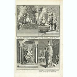
Idole que les chinois appellant, le dieu de l´immortalité, et qu´ils disent presider a leur Fortune. . .
Four fascinating engraving on one sheet depicting Chinese gods. "Idole que les chinois appellant, le dieu de l´immortalité, et qu´ils disent presider a leur Fortu...
- $150 / ≈ €140
Place & Date: Amsterdam, J.F. Bernard c.1736
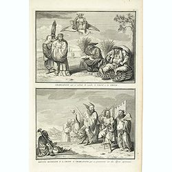
Charlatans qui se mêlent de vendre le vent de la Chine. Dévots mendiants de la Chine et charlatans qui se promènent sur des tigres apprivoisés, . . .
Two fascinating engraving on one sheet depicting Chinese charlatans. Engraved by Bernard Picart. Published in Jean Frederic Bernard's monumental "Cérémonies et cou...
- $150 / ≈ €140
Place & Date: Amsterdam, J.F. Bernard c.1736
L'Empire de la Chine.
A fine map of China, Korea and Taiwan.Jacques Nicholas Bellin (1703-1772) was one of the most important and proficient French cartographers of the mid-eighteenth century....
- $450 / ≈ €421
Place & Date: Paris, 1748
China.
This detailed map of China includes text giving measurements of "The Great Chinese Wall".The map was published in "Lizars' Edinburgh Geographical General A...
- $300 / ≈ €281
Place & Date: Edinburg, 1842

Collection of rubbings with portraits and biographies of famous Chinese philosophers, poets and legendary wise old men.
Collection of portraits and biographies of famous Chinese philosophers, poets and legendary wise old men. All portraits and text are original rubbings from stone tables d...
- $15000 / ≈ €14036
Place & Date: China or Korea, c. 1701
Tabula chronologica historiae Sinicae connexa cum cyclo qui vulgo Kia Tse dictur.
A set of two sheets of colored copper engravings. First published in 1729 in Rome in three sheets. Timeline of China's history with a chronological overview of the dynast...
- $1200 / ≈ €1123
Place & Date: Augsburg, 1746
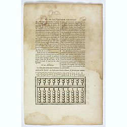
Souan pan, ou instrument dont les chinois se servent pour compter.
Text page with a wood block illustration of a souan-pan [suan-p'an] the calculation table used by the Chinese. Jean Baptiste Bourguignon d' Anville (1697-1782), French c...
- $20 / ≈ €19
Place & Date: Paris, P.G. Le Mercier, 1735
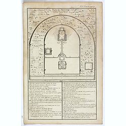
Plan du Tien-tang ou du temple, où l'empereur sacrifie à Chang-ti sous le titre de souverain seigneur de la terre.
Nice example of d'Anville's plan of Tien-tang 天堂 [Tiantang] temple, from "Atlas général de la Chine..."" prepared by Jesuit mission...
Place & Date: Paris, P.G. Le Mercier, 1735
Selling price: $8
Sold in 2017
Plan du Ti-tang ou du temple, où l'empereur sacrifie à Chang-ti sous le titre de souverain seigneur de la terre
Nice example of d'Anville's plan of Tien-tang 天堂 [Tiantang] temple, from "Atlas général de la Chine..." prepared by Jesuit missionaries ...
Place & Date: Paris, P.G. Le Mercier, 1735
Selling price: $14
Sold in 2017
Carte du ciel et de la terre qui commencent à se former / Figure du ciel fluide & pur & de la terre fixe & ferme.
Recto and verso text page with two illustrations of the grounding of the sky and earth according to a Chinese philosopher. Jean Baptiste Bourguignon d' Anville (1697-178...
- $75 / ≈ €70
Place & Date: Paris, P.G. Le Mercier, 1735
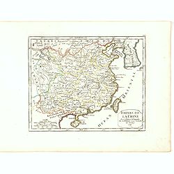
Empire de la Chine Par le Sr. Robert de Vaugondy fils de Mr. Robert Geog. Ord du Roi avec Privilege 1749.
Small detailed map of China, and Corea, including Taiwan. From Atlas Portatif Universel, by Robert de Vaugondy.Page 165 outside border top right. First and only state.The...
- $150 / ≈ €140
Place & Date: Paris, 1749
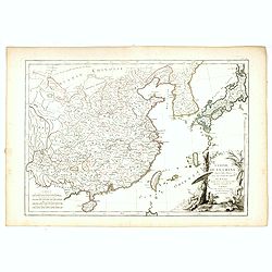
L'Empire de la Chine d'après l'Atlas Chinois, avec les Isles du Japon..
Attractive map of eastern part of China, including Taiwan, Korea and Japan. With ornamental title cartouche. Boundaries outlined in hand color.From theAtlas moderne ou co...
- $300 / ≈ €281
Place & Date: Paris, ca 1783
Carte de la Chine et du Japon. Dressée pour l'intelligence de l'histoire général des voyages de Laharpe. . .
Engraved by Tardieu for L'Intelligence de l'histoire generale des Voyages de Laharpe .Rare and detailed map of China, Korea, Japan and Taiwan (I.Formose ou Pekan).
- $275 / ≈ €257
Place & Date: Paris, 1821
Chinae, olim Sinarum regionis. . .
The first printed map of China. It is signed by Ludovico Georgio, whose real name was Luis Jorge de Barbuda. He was a Portuguese Jesuit cartographer and besides that a sp...
- $6000 / ≈ €5614
Place & Date: Antwerp, 1608
Vue perspective de la grande Rue de Nanquin ancienne Ville de la Chine.
So-called optical print of a street in Nanking. The wide boulevard is lined with merchants displaying their wares with colorful flags and signs. The street is filled with...
- $500 / ≈ €468
Place & Date: Paris, c.1780
La Chine Royaume. . .
An important and attractive French map of the whole of China, the northern tip of the Philippines, with a strangely curved Korea and an under-sized Taiwan here called &qu...
- $2600 / ≈ €2433
Place & Date: Paris, 1656
Platte Grond vande Stadt Macao.
A fine view of the city of Macao from Lappa Island showing in schematic blocks the structure of the town. With European vessels and junks in the surrounding water. With n...
- $750 / ≈ €702
Place & Date: Amsterdam, 1724
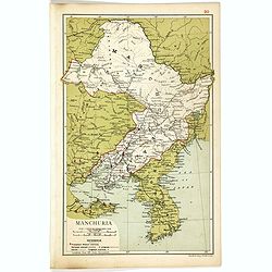
Manchuria.
Map of Manchuria and Korea. With in lower left corner scales in miles and kilometers, Protestant Mission Stations, railways both opened and in progress, canals and telegr...
- $75 / ≈ €70
Place & Date: London, 1910
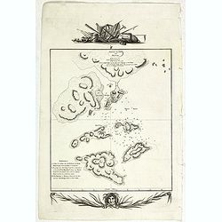
Sketch of the Typa and Macao.
A map of the environs of the Portuguese settlement of Macao in the Far East. The map shows a small town plan of Macao, nearby rocks, shoals depth soundings, and a few nav...
- $150 / ≈ €140
Place & Date: London, 1785
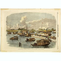
Sick and wounded embarking at Hong-Kong on Board the Steamer.
Large view of the harbour with numerous ships and people. From the Illustrated London News, October 23, 1858.
- $75 / ≈ €70
Place & Date: London, October 1858
China.
A nice mid-eighteenth-century map of China, extending from the island of Hainan in the south, to the Kobi Desert in the north, from Lake Puka in Tibet in the west to Kore...
- $150 / ≈ €140
Place & Date: Edinburgh, 1778
Chine et Japon.
Detailed map of China, Korea, Taiwan and Japan, prepared by Charles V. Monin (fl.1830-1880) a French cartographer of Caen and Paris. Published in Atlas Universel de Géog...
- $75 / ≈ €70
Place & Date: Paris, 1845
China Veteribus Sinarum Regio.
This was the first of Blaeu's maps of China. In 1655 he was to publish the famous map of Father Martini, with many of the earlier inaccuracies present on this map correct...
- $2200 / ≈ €2059
Place & Date: Amsterdam, 1644
China sea. Tong King Gulf Compiled from the latest British and Foreign Government surveys to 1886. . .
Detailed Map of Chart of Annam Gulf or Tong King Gulf, in the China Sea. Chart with legend and scale. British Admiralty chart No. 2062, published June 1881, large correct...
- $400 / ≈ €374
Place & Date: London, 1881 updated to 1957
China east coast Yellow Sea and Gulf of Pechili
Very detailed chart of China's east coast with the Yellow Sea and Gulf of Pechili. Scale: circa 1:1m. Inscription: J & C Walker sculpt. One inset: Pekin to the Gulf o...
- $450 / ≈ €421
Place & Date: London, 1840 - 1859
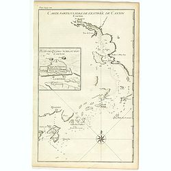
Carte particulière de l'entrée de Canton - Plan de Quang-tcheou-fou vulgo Canton .
Beautiful detailed map of the entrance to the city of Canton, showing also the cities of Macao and Quanghai, as well as the islands of the bay, including the island of Sh...
- $450 / ≈ €421
Place & Date: Paris, P.G. Le Mercier, 1735
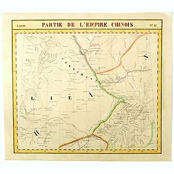
Partie de L'Empire Chinois - No.47.
One of Vandermaelen's 378 conjoined maps on a uniform scale to made up the total globe. This map features the Eastern Mongolia portion of China with Oloa Baytin. Interest...
- $75 / ≈ €70
Place & Date: Brussels, 1825-1827
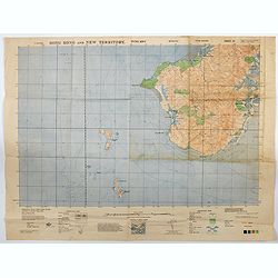
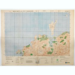
Hong Kong and New Territory - Tung Kwu.
A third edition air survey map of this portion of Lantau Island, to the west of Hong Kong, performed by the RAF. Originally published in 1931, then with minor corrections...
- $300 / ≈ €281
Place & Date: London, 1945
Hong Kong and New Territory - Tai O.
A third edition air survey map of this mainland portion of north west Hong Kong and New Territory, performed by the RAF. Originally published in 1931, then with minor cor...
- $400 / ≈ €374
Place & Date: London, 1945
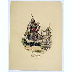
Garde Imperiale. Cavalier et Fantassin.
A decorative, colored lithograph of a Guard in the Chinese Imperial Army, and that of a Cavalier. From the work by Malpiere titled: " La Chine, Moeurs, Usages, Arts ...
- $50 / ≈ €47
Place & Date: Paris, ca. 1825
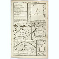
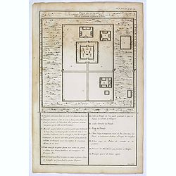
Villes de la province de Petche-li.
Five town plans : Peking (with forbidden town), Yung-ping-fou, Long-men-hien, Yuen-keou/Tching-sse-yu/Si-yang-keou/Hoang-tou-in, Tchin-ting-fou. From "Description ge...
- $150 / ≈ €140
Place & Date: Paris, P.G. Le Mercier, 1735