Search Listings matching "hondius" in Asia

Ormus
A lovely map of miniature map the Kingdom of Ormus, published by Petrus Bertius, and published in Amsterdam at the beginning of the seventeenth century. With an attractiv...
Place & Date: Amsterdam, 1606
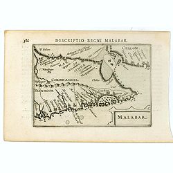
Malabar.
Very fine early miniature map of southern part of India and a part of Ceylon island. Title cartouche on the lower right corner.First published in 1598 in his Caert-Threso...
- $200 / ≈ €171
Place & Date: Amsterdam, Cornelis Claes, 1606

Iava Maior.
Very fine miniature map of Java, engraved by Benjamin Wright (1575-1613). This early map contains detailed geography and nomenclature around the northern coastline of the...
Place & Date: Amsterdam, Cornelis Claes, 1606
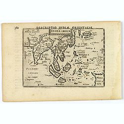
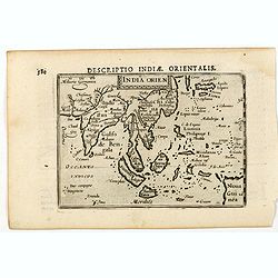
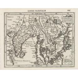
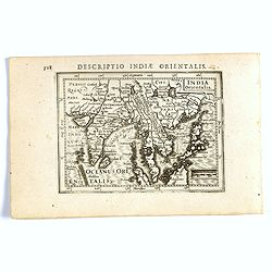
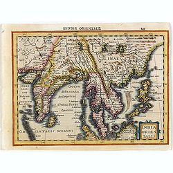
India Orientalis.
This lovely miniature map shows the East Indies, stretching from Persia to China and Japan, down to Java, and part of Papua new Guinea. Published by Petrus Bertius, in Am...
Place & Date: Amsterdam, 1606
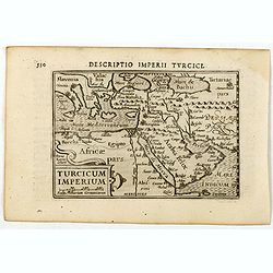
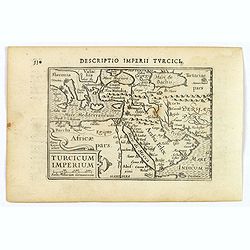
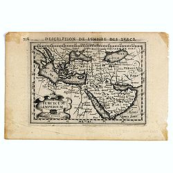
Descriptio Imperii Turcici / Turcicum Imperium.
A rare miniature map of the Arabian Peninsular. Title cartouche on the lower right corner.First published in 1598 in his Caert-Thresoor, the plates were executed by the m...
- $300 / ≈ €256
Place & Date: Amsterdam, Cornelis Claes, 1606
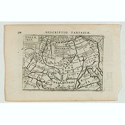
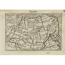
Descriptio Tartariae / Tartaria.
A rare miniature map of Tartary and China, showing the Great Wall. Title cartouche on the upper left corner.First published in 1598 in his Caert-Thresoor, the plates were...
- $300 / ≈ €256
Place & Date: Amsterdam, Cornelis Claes, 1606

Descriptio Arabie / Arabia.
A rare miniature map of the Arabian Peninsular. The title cartouche on the lower right corner.First published in 1598 in his Caert-Thresoor, the plates were executed by t...
Place & Date: Amsterdam, Cornelis Claes, 1606
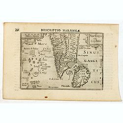
Descriptio Narsingae / Narsinga et Ceylon.
A rare miniature map of the southern part of India with Sri Lanka. The title cartouche on the upper right corner.First published in 1598 in his Caert-Thresoor, the plates...
- $350 / ≈ €299
Place & Date: Amsterdam, Cornelis Claes, 1606
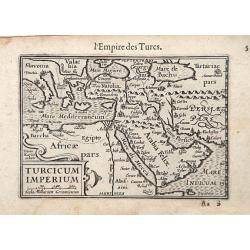
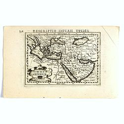
Turcicum Imperium.
A really attractive miniature map of The Turkish Empire, as it was at the beginning of the seventeenth century. Published by Petrus Bertius in Amsterdam. The map stretche...
Place & Date: Amsterdam, 1606
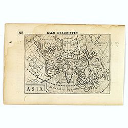
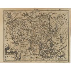
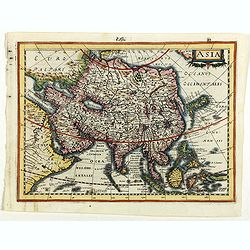
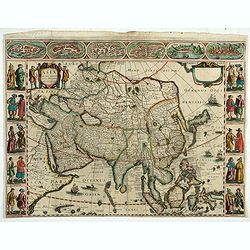
Asia.
A miniature map of the continent of Asia, published by Petrus Bertius in Amsterdam, at the beginning of the seventeenth century. An attractive small map featuring hatchin...
- $250 / ≈ €214
Place & Date: Amsterdam, 1606
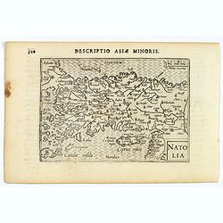
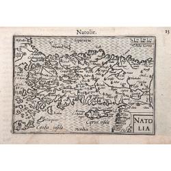
Natolia.
A miniature map of Turkish Natolia, published by Petrus Bertius in Amsterdam, at the beginning of the seventeenth century. This attractive small map features hatching in ...
- $150 / ≈ €128
Place & Date: Amsterdam, 1606
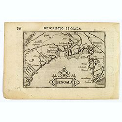
Bengala.
A lovely miniature map of a section of the Bay of Begal, published by Petrus Bertius, in Amsterdam at the beginning of the seventeenth century. There is a decorative stra...
Place & Date: Amsterdam, 1606

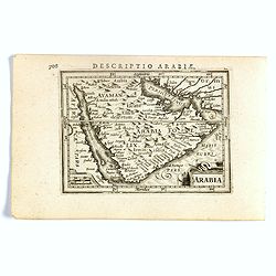
Arabia
A lovely miniature map the Arabian Peninsular, published by Petrus Bertius, and published in Amsterdam at the beginning of the seventeenth century. With an attractive s...
Place & Date: Amsterdam, 1606
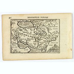
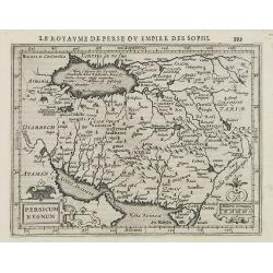
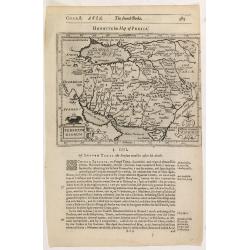
Persia.
A decorative miniature map of Persia, stretching from the Tigris River in the west to the Indus River in the east. As far north as the Caspian Sea. Published by Petrus B...
- $175 / ≈ €150
Place & Date: Amsterdam, 1606
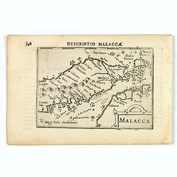
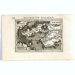
Malacca.
A nice miniature map of Malacca, A Malaysian state on the southern Malay peninsular, next to the Strait of Malacca. North is orientated to the left Published by Petrus B...
- $300 / ≈ €256
Place & Date: Amsterdam, 1606
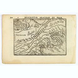
Aracam.
A rare miniature map of Thailand and Burma. Title cartouche on the upper left corner. First published in 1598 in his 'Caert-Thresoor', the plates were executed by the mos...
Place & Date: Amsterdam, 1606
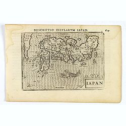
Iapon.
An attractive miniature map of Japan, published by Petrus Bertius, in Amsterdam at the beginning of the seventeenth century.The quirky map is shows the country in a disto...
- $250 / ≈ €214
Place & Date: Amsterdam, 1606
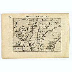
Descriptio Cambaiae.
A very decorative little map of northern India with Gujarat and the Indus river, bordering Pakistan. Naming major towns represented by symbols, major rivers, mountains, a...
- $100 / ≈ €85
Place & Date: Amsterdam, 1606
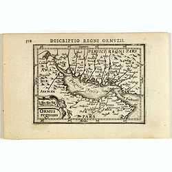
Descriptio Regni Ormuzii / Ormus.
A rare miniature map of the Street of Ormus. Title cartouche on the lower left corner.First published in 1598 in his Caert-Thresoor, the plates were executed by the most ...
- $450 / ≈ €385
Place & Date: Amsterdam, 1606
India Orien.
A miniature map showing India and the islands of Borneo, New Guinea, Sumatra, Java, etc.Korea as an enlonged peninsular and one town marked.First published in 1598 in his...
- $400 / ≈ €342
Place & Date: Amsterdam, Cornelis Claes, 1606
Asia.
Map of Asia with an oversized Korea and a curious shape for Japan, from the first French-text edition of Jodocus Hondius' Atlas Minor.Shortly after the publication of the...
Place & Date: Amsterdam, 1608
Indiae Orientalis.
This map covers an area including India, part of Malaysia, Borneo and China.From the first French-text edition of Jodocus Hondius' Atlas Minor.Shortly after the publicati...
Place & Date: Amsterdam, 1608
Persicum Regnum.
Early map of Persia, from the first French-text edition of Jodocus Hondius' Atlas Minor.Shortly after the publication of the big folio-atlases the need was apparently fel...
- $100 / ≈ €85
Place & Date: Amsterdam, 1608

Maldivae Insulae.
Very fine early miniature map of Maldives Islands. East is at the top. Title cartouche on the lower right corner. A dolphin and two ships are depicted.First published in ...
Place & Date: Amsterdam / Frankfurt, 1609

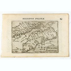
Sumatra Insula.
A miniature map of Sumatra and the Malay Peninsula, including Singapore and the various islands directly south of it. Containing detailed geography and nomenclature aroun...
Place & Date: Amsterdam, 1609
Sumatra Insula.
A miniature map of Sumatra containing detailed geography and nomenclature around the entire island. The neighbouring coast of the Malay Peninsula is shown, including Sing...
- $450 / ≈ €385
Place & Date: Amsterdam/Frankfurt 1609
Natolia.
A miniature map of the Arabian peninsula, including Cyprus. The title cartouche on the lower right corner.First published in 1598 in his Caert-Thresoor, the plates were e...
- $200 / ≈ €171
Place & Date: Amsterdam / Frankfurt, 1609
Turcicum Imperium / Empire Turc.
A miniature map of the Arabian peninsula, centered on Jerusalem. Title cartouche on the lower left corner.First published in 1598 in his Caert-Thresoor, the plates were e...
Place & Date: Amsterdam/Frankfurt 1609
Tartaria.
A miniature map showing China, Korea and Russia. Title cartouche on the upper left corner.First published in 1598 in his Caert-Thresoor, the plates were executed by the m...
Place & Date: Amsterdam, 1609
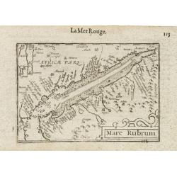
Mare Rubrum / Mer Rouge.
Wonderful miniature map includes the Red Sea, Yemen, and the east coast of the Arabian peninsula. One of the early maps to focus on this area. The title cartouche on the ...
Place & Date: Amsterdam / Frankfurt, 1609
Malacca.
FIRST IMPRINT FROM THE NEWLY ENGRAVED PLATES IN 1616. - A rare miniature map of Malacca, Borneo, part of Sumatra . Latin text on verso.First published in 1598 in his Caer...
Place & Date: Amsterdam, J. Hondius, 1616
Arabia.
FIRST IMPRINT FROM THE NEWLY ENGRAVED PLATES IN 1616. - A rare miniature map of the Arabian Peninsular. Title cartouche on the lower left corner.First published in 1598 i...
Place & Date: Amsterdam, J. Hondius, 1616
India Orientalis.
FIRST IMPRINT FROM THE NEWLY ENGRAVED PLATES IN 1616. - A rare miniature map of the East Indies.First published in 1598 in his Caert-Thresoor, the plates were executed by...
Place & Date: Amsterdam, J. Hondius, 1616
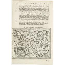
Turicum imperium.
FIRST IMPRINT FROM THE NEWLY ENGRAVED PLATES IN 1616. - A rare miniature map of the Ottoman empire with Turkey and the Arabian Peninsular. Title cartouche on the lower le...
Place & Date: Amsterdam, J. Hondius, 1616
Turcicum Imperium.
FIRST IMPRINT FROM THE NEWLY ENGRAVED PLATES IN 1616. - A rare miniature map of the Arabian Peninsular. Title cartouche on the lower left corner.First published in 1598 i...
- $500 / ≈ €427
Place & Date: Amsterdam, J. Hondius, 1616
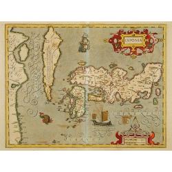
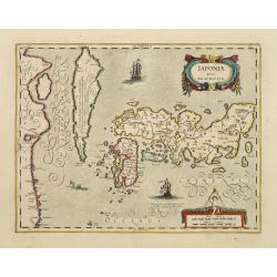
Japonia.
Jodocus Hondius' fine map early 17th-century map of the islands of Japan, was first issued as one of the new maps in the expended Mercator Hondius Atlas of 1606.The map i...
Place & Date: Amsterdam, 1606-1620
![Narsinga. [India]](/uploads/cache/38123-250x250.jpg)
Narsinga. [India]
Small map illustrating the Indian peninsular. Oriented with East on top, surrounded by text in Dutch.Nicolaes de Clerck (de Klerc) was active as engraver and publisher in...
- $225 / ≈ €192
Place & Date: Amsterdam, Cloppenburch, 1621
Malabar.
Small map illustrating the southwestern sea coast of India. Oriented with East on top, surrounded by text in Dutch.Included in the rare book : Wereld Spiegel, waer in ver...
- $200 / ≈ €171
Place & Date: Amsterdam, Cloppenburch, 1621
Bengala.
Small map centered on the Bay of Bengal, surrounded by text in Dutch. Nicolaes de Clerck (de Klerc) was active as engraver and publisher in Delft from 1599-1621.Included ...
- $150 / ≈ €128
Place & Date: Amsterdam, Cloppenburch, 1621
Malabar.
Small map illustrating the south western seacoast of India. Oriented with East on top, surrounded by text in Dutch.Nicolaes de Clerck (de Klerc) was active as engraver an...
- $175 / ≈ €150
Place & Date: Amsterdam, Cloppenburch, 1621
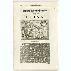
China.
Small map illustrating China with the Great Wall and Korea as an island, surrounded by text in Dutch.Nicolaes de Clerck (de Klerc) was active as engraver and publisher in...
- $200 / ≈ €171
Place & Date: Amsterdam, Cloppenburch, 1621
Turcicum Imperium.
The rare Samuel Purchas' edition of the Mercator / Hondius "Atlas Minor" atlas map. Early map of Turkey, the Arabian pen insular and eastern part of the Mediter...
Place & Date: London, 1625
India Orientalis.
The rare Samuel Purchas' edition of the Mercator/Hondius Atlas Minor atlas map. Thisearly map of the East Indies was published in his famous collection of voyages His Pil...
- $300 / ≈ €256
Place & Date: London, 1625
Persicum Regnum.
The rare Samuel Purchas' edition of the Mercator/Hondius Atlas Minor atlas map. Early map of Turkey, including Cyprus published in his famous collection of voyages His Pi...
- $115 / ≈ €98
Place & Date: London, 1625
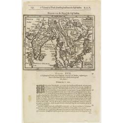
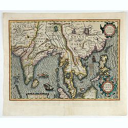
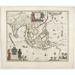
India Orientalis.
Map covering India, Thailand, Philippines, Northern Borneo and the coast of Southern China. From the rare Cloppenburg edition "Atlas Sive Cosmographicae Meditationes...
- $550 / ≈ €470
Place & Date: Amsterdam, 1630

India Orientalis.
Published in Hondius' editions of the Mercator Atlas from 1606 onwards, showing the Indian subcontinent, the Malay Peninsula, Siam and Cambodia, China and the Philippines...
Place & Date: Amsterdam, 1630
Asia.
Asia map from the rare Cloppenburg edition slightly larger format and more scarce edition of the Mercator/Hondius "Atlas Minor". Engraved by Pieter Van Den Keer...
Place & Date: Amsterdam, 1630
India Orientalis.
Published in Hondius' editions of the Mercator Atlas from 1606 onwards, showing the Indian subcontinent, the Malay Peninsula, Siam and Cambodia, China and the Philippines...
- $2000 / ≈ €1710
Place & Date: Amsterdam, 1630
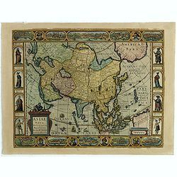
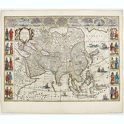
Asia recens summa cura delineata.
This is the rare early issue with decorative paneled borders. In upper border views and plans of Famagusta, Rhodos, Damascus, Jerusalem, Aden and Ormus. Originally engrav...
Place & Date: Amsterdam, 1632

Tartaria.
Published in Hondius' editions of the Mercator Atlas from 1606 onwards, China, Korea, and the northern Pacific coast of America are shown as two continents separated by t...
Place & Date: Amsterdam, 1633
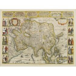
Asiae Nova Descriptio.
Final State of Pieter Van Den Keere's Rare Map of Asia--The first map of Asia to include decorative panels.The map has an interesting south positioning of the Caspian Sea...
Place & Date: Amsterdam, 1636
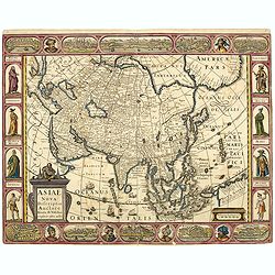
Asiae Nova Descriptio.
Final State of Pieter Van Den Keere's Rare Map of Asia -- The first map of Asia to include decorative panels. Published by N.J.Visscher and engraved by Abraham Goos, embe...
Place & Date: Amsterdam, 1636
Tartaria sive Magni Chami imperium.
Detailed and decorative map of Tartary and Northern part of China. Northern tip of Korea included. The Chinese Great Wall is depicted, with Central Asia, extending from M...
- $500 / ≈ €427
Place & Date: Amsterdam, 1638

Carte de l'Asie, corrigée et augmentée, dessus toutes les aultres Faict L année 1640.
Map of Asia with a dedication to Pierre Petit. The map bears a very close resemblance to the Asia maps of the Hondius family. Michael Van Lochom (1601-1647) was a Calvini...
Place & Date: [Paris], 1640
Asia noviter delineata. . .
From 1633 the members of the Blaeu family were official cartographers to the United East India Company and, as such, had access to the most up-to-date cartographic inform...
Place & Date: Amsterdam, 1644
India quae Orientalis dicitur, et insulae adiacentes.
Extending from India to Japan and showing parts of Australia. It is indeed one of the first printed maps to show identifiable parts of Australia. It was not revised until...
Place & Date: Amsterdam, 1644
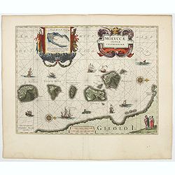
Moluccae Insulae Celeberrimae.
Showing the geographical features of the islands, and decorated with ships, sea monsters and a handsome cartouche. With an inset of Bachian island. From early on Willem ...
- $750 / ≈ €641
Place & Date: Amsterdam, 1644
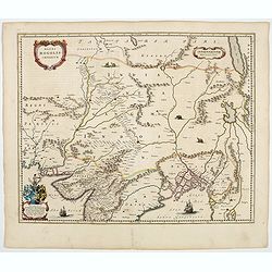
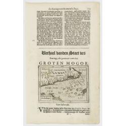
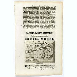
Magni Mogolis Imperium.
An attractive map of the region from Iran through Afghanistan, Tibet, and northern India across to Burma. The travel route from Kabul to Surat is the most prominent featu...
- $350 / ≈ €299
Place & Date: Amsterdam, 1644
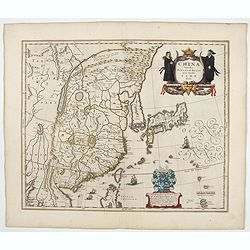
China Veteribus Sinarum Regio.
This was the first of Blaeu's maps of China. In 1655 he was to publish the famous map of Father Martini, with many of the earlier inaccuracies present on this map correct...
- $2200 / ≈ €1881
Place & Date: Amsterdam, 1644
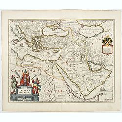
Turcicum Imperium.
A very handsome map with a particularly fine cartouche showing the Turkish Sultan on his throne and allegorical figures at either side brandishing weapons. At the right i...
- $1800 / ≈ €1539
Place & Date: Amsterdam, 1644
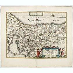
TERRA SANCTA quae in Sacris Terra Promissionis...
The Holy Land, Promised Land or Palestine. Oriented to the west. Shows the entire Palestine on both sides of the Jordan, the shore line running from Tripoli as far as the...
- $1000 / ≈ €855
Place & Date: Amsterdam, 1644
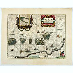
Moluccae Insulae Celeberrimae.
Showing the geographical features of the islands and decorated with ships, sea monsters and a handsome cartouche. With an inset of Bachian island. From early on Willem J...
- $750 / ≈ €641
Place & Date: Amsterdam, ca.1645
Japoniae Nova Descriptio.
The map is identical in cartographic detail to the Hondius map of 1606 but newly designed ornate cartouches have been added. The three main islands of Japan are shown wit...
Place & Date: Amsterdam 1650
Asia recens Summa cura delineata.
Rare map of Asia published in Pierre d'Avity's "Les Estats Empires, Royaumes, Et Principautez Du Monde". Derivative map of Hondius' rare separately issued map o...
- $3000 / ≈ €2565
Place & Date: Paris, ca. 1659

Arabia.
A handsome map of the Arabian Peninsula drawn on a large scale on which the three classical divisions are shown with some urban centers and topographical features. A cert...
Place & Date: Amsterdam, 1662

Insularum Moluccarum Nova description.
Exquisite map of the famous Spice Islands based on the islands described by Jan Huyghen van Linschoten. This map was the first large-scale map of the region and depicts t...
Place & Date: Amsterdam, 1730