Search Listings matching "anville" in Asia
![[East coast of Africa, Arabia and west coast of India.]](/uploads/cache/04762-250x250.jpg)
[East coast of Africa, Arabia and west coast of India.]
Rare. Map of the east coast of Africa, Including Madagascar, the Arabian Peninsular, coast of Pakistan and west coast of India.Prepared by Joao Teixeira in 1649, this cha...
Place & Date: Paris, 1664-1696
![Province de Ho-nan. [Honan 河南 (Hénán) province]](/uploads/cache/39696-250x250.jpg)
Province de Ho-nan. [Honan 河南 (Hénán) province]
An important map of Honan 河南 (Hénán) province. With a quite elaborately pictorial cartouche, engraved by F.Baillieul Lainé. Jean Baptiste Bourguignon d' Anville (1...
- $200 / ≈ €175
Place & Date: Paris, P.G. Le Mercier, 1735
Description geographique, historique, chronologique, politique, et physique de l'empire de la Chine et de la Tartarie chinoise.
Cornerstone of any collection of books on China, which is also among the rarest and most desirable of important Americana.This, "the first definitive European work o...
Place & Date: Paris, P. G. Le Mercier, (vol. 1-3) 1770 / (vol.4),1735
Province d'Yun-Nan.
Important map of Yun-nan 云南 [Yunnan] province. With a quite elaborately pictorial cartouche featuring a rococo chinoiserie ornamentation, engraved by Delahaye. Jean B...
- $100 / ≈ €88
Place & Date: Paris, P.G. Le Mercier, 1735
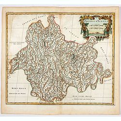
Province de Koei-Tcheou.
An important map of Koei-tcheou 贵州 [Guizhou]. With a quite elaborately pictorial cartouche featuring a rococo chinoiserie ornamentation engraved by Guélard, the map ...
- $100 / ≈ €88
Place & Date: Paris, P.G. Le Mercier, 1735
Description geographique, historique, chronologique, politique, et physique de l'empire de la Chine et de la Tartarie chinoise.
First edition of this cornerstone of any collection of books on China, which is also among the rarest and most desirable of important Americana, included in Rare American...
- $30000 / ≈ €26282
Place & Date: Paris, P. G. Le Mercier, 1735
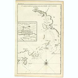
Carte particulière de l'entrée de Canton - Plan de Quang-tcheou-fou vulgo Canton .
Beautiful detailed map of the entrance to the city of Canton, showing also the cities of Macao and Quanghai, as well as the islands of the bay, including the island of Sh...
- $450 / ≈ €394
Place & Date: Paris, P.G. Le Mercier, 1735
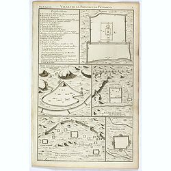
Villes de la province de Petche-li.
Five town plans : Peking (with forbidden town), Yung-ping-fou, Long-men-hien, Yuen-keou/Tching-sse-yu/Si-yang-keou/Hoang-tou-in, Tchin-ting-fou. From "Description ge...
- $150 / ≈ €131
Place & Date: Paris, P.G. Le Mercier, 1735
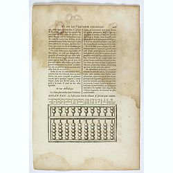
Souan pan, ou instrument dont les chinois se servent pour compter.
Text page with a wood block illustration of a souan-pan [suan-p'an] the calculation table used by the Chinese. Jean Baptiste Bourguignon d' Anville (1697-1782), French c...
- $20 / ≈ €18
Place & Date: Paris, P.G. Le Mercier, 1735
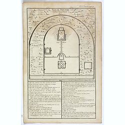
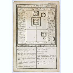
Plan du Tien-tang ou du temple, où l'empereur sacrifie à Chang-ti sous le titre de souverain seigneur de la terre.
Nice example of d'Anville's plan of Tien-tang 天堂 [Tiantang] temple, from "Atlas général de la Chine..."" prepared by Jesuit mission...
Place & Date: Paris, P.G. Le Mercier, 1735
Selling price: $8
Sold in 2017
Plan du Ti-tang ou du temple, où l'empereur sacrifie à Chang-ti sous le titre de souverain seigneur de la terre
A plan of the temple of the soil god (社稷壇, Shèjìtán, "Altar of Soil and Grain")—under the name "Titang" (地堂, dìtáng, "Hall of Di...
- $50 / ≈ €44
Place & Date: Paris, P.G. Le Mercier, 1735
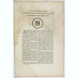
Carte du ciel et de la terre qui commencent à se former / Figure du ciel fluide & pur & de la terre fixe & ferme.
Recto and verso text page with two illustrations of the grounding of the sky and earth according to a Chinese philosopher. Jean Baptiste Bourguignon d' Anville (1697-178...
- $75 / ≈ €66
Place & Date: Paris, P.G. Le Mercier, 1735
![Province de Se-Tchuen. [ Se-tchuen 四川 [Sichuan] province.]](/uploads/cache/39699-250x250.jpg)
Province de Se-Tchuen. [ Se-tchuen 四川 [Sichuan] province.]
Important map of Se-tchuen 四川 [Sichuan] province. With a quite elaborately pictorial cartouche, engraved by Guélard, the map by Delahaye, features animals, birds, a ...
- $450 / ≈ €394
Place & Date: Paris, P.G. Le Mercier, 1735
![Province de Chan-Si. [Chan-s 山西i [Shanxi] province. ]](/uploads/cache/39697-250x250.jpg)
Province de Chan-Si. [Chan-s 山西i [Shanxi] province. ]
An important map of Chan-s 山西i [Shanxi] province. With a quite elaborately pictorial cartouche, engraved by Guélard, the map by Delahaye. Jean Baptiste Bourguignon d...
- $200 / ≈ €175
Place & Date: Paris, P.G. Le Mercier, 1735
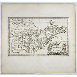
Province de Chan-Tong.
Detailed map of Shandong Province. With a quite elaborately pictorial cartouche, engraved by Guélard, the map by Delahaye, featuring a rabbit and rococo chinoiserie orna...
- $300 / ≈ €263
Place & Date: Paris, P.G. Le Mercier, 1735
![Province de Tche Kiang. [Tche kiang 浙江 [Zhejiang] province]](/uploads/cache/39693-250x250.jpg)
Province de Tche Kiang. [Tche kiang 浙江 [Zhejiang] province]
D'Anville's highly detailed map of Tche kiang 浙江 [Zhejiang] province from du Halde's "Description geographique historique...de l'Empire de la Chine et de la Tart...
- $400 / ≈ €350
Place & Date: Paris, P.G. Le Mercier, 1735
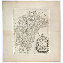
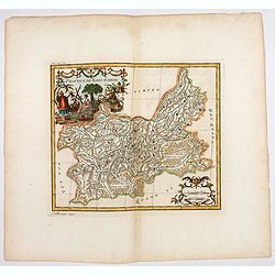
Province de Kiang-Si. Jiangxi 江西 province.
An important map of Jiangxi 江西 province. With a quite elaborately pictorial cartouche featuring a rococo chinoiserie ornamentation, engraved by Guélard. The map itse...
- $200 / ≈ €175
Place & Date: Paris, P.G. Le Mercier, 1735
![Province de Pe-Tche-Li. Pe-tche-li [Beizhili] 北直隶 [= 河北]. province.]](/uploads/cache/39689-250x250.jpg)
Province de Pe-Tche-Li. Pe-tche-li [Beizhili] 北直隶 [= 河北]. province.]
Important map of Pe-tche-li [Beizhili] 北直隶 [= 河北]. With a quite elaborately pictorial cartouche featuring a rococo chinoiserie ornamentation, engraved by Guéla...
- $300 / ≈ €263
Place & Date: Paris, P.G. Le Mercier, 1735
![Province de Koei-Tcheou. [Koei-tcheou 贵州 [Guizhou] province.]](/uploads/cache/39688-250x250.jpg)
Province de Koei-Tcheou. [Koei-tcheou 贵州 [Guizhou] province.]
Important map of Koei-tcheou 贵州 [Guizhou]. With a quite elaborately pictorial cartouche featuring a rococo chinoiserie ornamentation, engraved by Guélard, the map by...
- $300 / ≈ €263
Place & Date: Paris, P.G. Le Mercier, 1735
![Carte de la province de Tche kiang 浙江 [Zhejiang]](/uploads/cache/30923-250x250.jpg)
Carte de la province de Tche kiang 浙江 [Zhejiang]
D'Anville's highly detailed map of Tche Kiang (Zhejiang) province from du Halde's "Description geographique historique...de l'Empire de la Chine et de la Tartarie Ch...
- $250 / ≈ €219
Place & Date: Paris, P.G. Le Mercier, 1735
![Province de Hou-Quang. [Hou-quang 湖广 [Huguang] province.]](/uploads/cache/39694-250x250.jpg)
Province de Hou-Quang. [Hou-quang 湖广 [Huguang] province.]
Important map of Hou-quang 湖广 [Huguang] province. With a quite elaborately pictorial cartouche, engraved by Guélard, the map engraved by F.Baillieul Lainé, featurin...
- $250 / ≈ €219
Place & Date: Paris, P.G. Le Mercier, 1735

Description geographique, historique, chronologique, politique, et physique de l'empire de la Chine et de la Tartarie chinoise . . . du Thibet, & de la Coree. . .
Without the separately published atlas. Lacking 2 plates in vol.2 (Obseques at p.149 and Gin seng at p.180), one plate torn without a loss (vol.1, p.230), d4 vol.1 with a...
Place & Date: The Hague, H. Scheurleer, 1736

Carte la plus generale et qui comprend la Chine, la Tartarie chinoise et le Thibet. . .
It has a quite elaborate pictorial cartouche engraved by G. Kondet. It is a very detailed map of China, Tibet, and Korea.In the upper left corner is very good details of ...
Place & Date: The Hague, 1737

Nouvel atlas de la Chine, de la Tartarie chinoise, et du Thibet.
First edition of "the principal cartographic authority on China during the 18th century". It was the second major atlas of China produced in Europe following th...
Place & Date: The Hague, H. Scheurleer, 1737
![Province de Fo-Kien. [Includes West Coast of Taiwan]](/uploads/cache/43503-250x250.jpg)
Province de Fo-Kien. [Includes West Coast of Taiwan]
An important map of Fujian Province shows the East Coast of China and the West Coast of Taiwan. It shows that for the Manchu Qing, only the western half of Formosa was co...
Place & Date: The Hague, H. Scheurleer, 1737
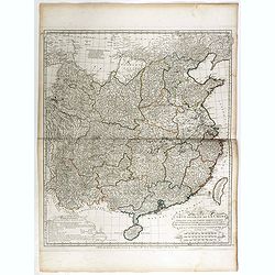
Carte générale de la Chine Dressée sur les Cartes particulières que l'Empereur Cang-hi a fait lever sur les lieux par les RR. PP. Jésuites missionaires dans cet empire / Par le Sr d'Anville.
Important and very detailed map of Southern part of China, including a detailed Taiwan. Jean Baptiste Bourguignon d' Anville (1697-1782) was a French cartographer and com...
- $1000 / ≈ €876
Place & Date: The Hague, H. Scheurleer, 1737

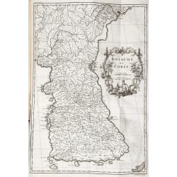
Royaume de Corée.
With a quite elaborately pictorial cartouche, engraved by G.Kondet. One of the earliest separate maps of Korea. Jean Baptiste Bourguignon d' Anville (1697-1782), French c...
Place & Date: The Hague, 1737

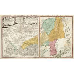
A map of Quan-Tong or Lyau-Tong province, and the kingdom of Kau-Li or Korea . . .
Detailed map of Korea, Liaodong, and the tip of Shandong Province prepared by Thomas Kitchin for Thomas Salmon's Universal Traveller, based on D'Anville's landmark map of...
- $600 / ≈ €526
Place & Date: London, 1747
Tartariae Sinensis mappa geographica ex Tabulis specialibus RRPP Iesuitarun nec non Relationibus R.P. Gerbillon / per Dom d'Anville, . . . primum A° 1732 nunc se Nunc secundum LL. projectionis . . . descripta per Tobiam Mayer
A very attractive map of Korea and Manchuria on the mainland and two islands of 'Ezo' and Sakhalin, prepared by Jean-Baptiste Bourguignon d'Anville (1697-1782) and Johann...
- $750 / ≈ €657
Place & Date: Nuremberg, 1749
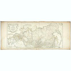
Troisième partie de la carte d'Asie, contenant la Sibérie, et quelques autres parties de la Tartarie. . .
Engraved map of Tartary on two sheets, with country boundaries in outline color. Includes geographic notes and ornamental cartouche by "H. Gravelot, invenit., DeLafo...
Place & Date: Paris, 1753
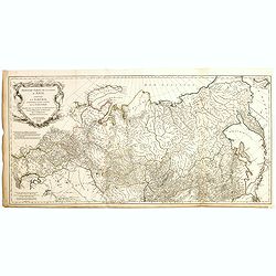
Troisième partie de la carte d'Asie, contenant la Sibérie, et quelques autres parties de la Tartarie. . .
Engraved map of Tartary on two sheets, with country boundaries in out line color. Includes geographic notes and ornamental cartouche by "H. Gravelot, invenit., DeLaf...
- $750 / ≈ €657
Place & Date: Paris, 1754
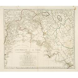
L'Euphrate et Le Tigre.
A detailed map prepared by D'Anville. Covering the Syrian Desert, Lebanon, and the mouth of the Tigris in the Persian Gulf. Including Babylon, Tripoli, etc.
- $150 / ≈ €131
Place & Date: Nuremberg, 1783
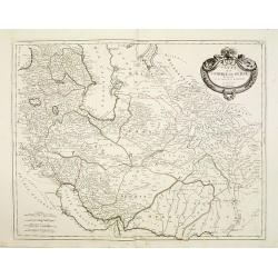
Carte de l'Empire de Perse...
Finely and crisply engraved map of the Persian Empire during the 18th century. It shows the Caspian Sea in the north to the Persian Gulf in the south, and from Armenia in...
Place & Date: Venice, 1779 - 1784
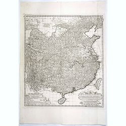
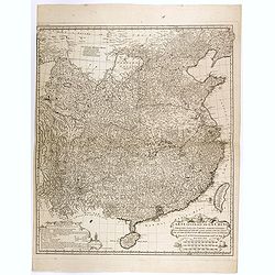
Carte Generale de la Chine Dressée sur les Cartes Particulieres Que l' Empereur Chang-Hi a fait lever sur les lieux..
Large map showing the traditional limits of China, including Hainan and Formosa in the South, and Quantong and parts of the Gobi Desert in the North.As the title notes, t...
Place & Date: Paris, Ph.-D. Pierres, Clousier [- Moutard], 1785
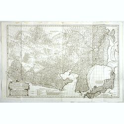
Carte Generale De La Tartarie Chinoise Dressee sur les Cartes Particulieres Faits Sur Les Lieux Par Les R.R. P.P. Jesuites . . . .MDCCXXXII
This is a very detailed map of the region from Japan to the Gobi Desert, centered on Mongolia and Korea, from D'Anville's Atlas of China. Jean Baptiste Bourguignon d' Anv...
Place & Date: Paris, Ph.-D. Pierres, Clousier [- Moutard], 1785

Carte d'Asie divisée en ses principaux Etats.
Uncommon and decorative "carte à figures" - wall map, prepared by Clouet, with superb decoration, including a wonderful rococo border with 20 decorative vignet...
Place & Date: Paris, Mondhare, 1787
Carte Generale de la Chine Dressée sur les Cartes Particulieres Que l' Empereur Chang-Hi a fait lever sur les lieux. . . .
With a quite elaborately pictorial cartouche, engraved by the master engraver Guillaume-Nicolas de la Haye (1727 -1802). Large map showing the traditional limits of China...
- $750 / ≈ €657
Place & Date: Paris, Dezauche, 1789–1799
Carte la plus generale et qui comprend la Chine, la Tartarie chinoise et le Thibet. . .
With a quite elaborately pictorial cartouche, engraved by G.Kondet. Very detailed map of China, Tibet and Korea. Jean Baptiste Bourguignon d' Anville (1697-1782), French ...
- $2700 / ≈ €2365
Place & Date: Paris, Dezauche, 1789–1799