Browse Listings in America > South America

Nieuwe gemeten kaart van de colonie de Berbice : met der zelver plantagien en de namen der bezitters in het ligt gebragt door Reiner & Iosua Ottens kaartverkopers te Amsterdam 1740.
Rare separately published map of the colony of Berbice in present-day Guyana showing the Berbice River Valley and the plantations along the river. North on map of the col...
Place & Date: Amsterdam, 1740
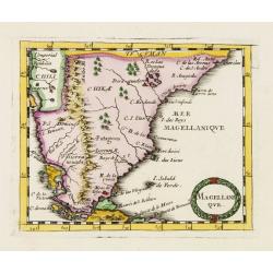
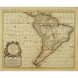
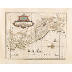
Magellani Que.
Uncommon miniature map of Argentina and Strait of Magellan from Pierre Duval's La Geographie Universeille dated 1676. Following his Cartes de geographie in 1657, Pierre D...
- $200 / ≈ €187
Place & Date: Paris, 1676

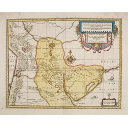
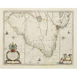
Paraquaria vulgo Paraguay cum adjacentibus.
Rare map only included in Joan Blaeu's Atlas major. Detailed map of Uruguay, Paraguay, Northern part of Argentina and northern part of Chili. Engraved by Gerard Coeck. Tw...
- $800 / ≈ €749
Place & Date: Amsterdam, 1660
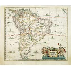
Americae pars meridionalis.
Decorated with several ships and sea monsters, and a cartouche flanked by engravings of six Indians, netted hammocks and South American fauna.
- $1500 / ≈ €1404
Place & Date: Amsterdam, 1650

Nuevo plano de la ciudad de Buenos Aires y parte del partido de avellaneda . . .
A rare detailed city plan of Buenos Aires prepared in 1912 by Ernesto Escalante. The plan depicts the city from the Partido de Avellaneda and the Villa Riachuelo to the R...
Place & Date: Buenos Aires, 1912

Guyana, Surinam, Amapa.
Very rare Ottoman printed map of Guyana, Suriname and Amapa. With Trinidad, an inset map of the mouth of the Rivers Essequibo, Courantyne, Suriname with Paramaribo.From C...
Place & Date: Üsküdar (Istanbul), 1803
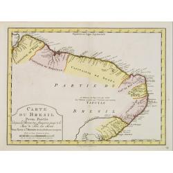
Carte du Bresil Prem.Partie...
Uncommon edition of this accurate map of the eastern part of Brazil.From Atlas Portatif pour servir a l'intelligence de l'Histoire Philosophique et Politique des etabliss...
- $100 / ≈ €94
Place & Date: Amsterdam, 1773
Paraguay o Prov. De Rio De La Plata cum regionibus adiacentibus Tucuman et Sta. Cruz De la Sierra.
An attractive map centered on Paraguay. Title cartouche on the upper right-hand corner, on the ocean a ship and a sea monster are depicted.
- $300 / ≈ €281
Place & Date: Amsterdam, 1708
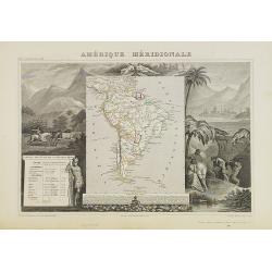
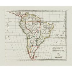
Amérique Méridionale.
A very decorative 19th century map of the continent colored to show political divisions. The map is surrounded by steel engraved scenes including horses, Indians, mining ...
Place & Date: Paris, c. 1850
![Hanc Tabulam continens Laetam Pharnambuci.. . [Brazil].](/uploads/cache/16521-250x250.jpg)
Hanc Tabulam continens Laetam Pharnambuci.. . [Brazil].
An extremely rare and decorative map of coast-line of Pernambuco. With one inset: In the upper left corner a map of Brazil, with title in five lines Dutch and five lines ...
Place & Date: Amsterdam, 1630
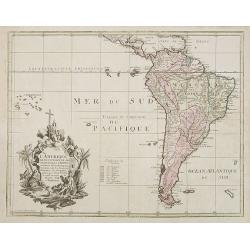
L'Amerique Meridionale Dressée sur les Observations..
Detailed map of South America prepared by De L'Isle, with fine title cartouche.The map is from a Dutch edition of De L'Isle's work entitled, Atlas Nouveau, Contenant Tout...
- $500 / ≈ €468
Place & Date: Amsterdam c. 1745
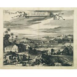
Serinhaim.
Fine view of a fort in Serinhaim, Brazil, with numbered key at the base. A procession of Portuguese or Dutch soldiers advance along the road carrying a litter. To the lef...
Place & Date: London, 1671
Carte de la Guyane Françoise et l'Isle de Cayenne..
A well engraved and highly detailed chart of French Guiana and the island of Cayenne. Made in 1763 by Jacques Bellin (1703-72), a prolific cartographer assigned the Minis...
- $500 / ≈ €468
Place & Date: Paris, 1763
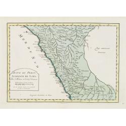
Suite de Perou Audience de Lima.
Uncommon edition of this accurate map showing the southern Peruvian coast, the ranges and villages of numerous Indian tribes are shown.FromAtlas Portatif pour servir a l'...
- $100 / ≈ €94
Place & Date: Amsterdam, 1756
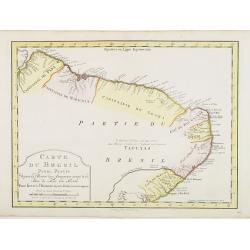
Carte du Bresil Prem. Partie..
Uncommon edition of this accurate map of eastern part of Brazil. In lower right engraved 29a.From Atlas Portatif pour servir a l''''intelligence de l''''Histoire Philosop...
Place & Date: Amsterdam, 1773
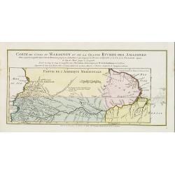
Carte du Cours du Maragnon ou .. Amazones..
Uncommon edition of this map of the river Amazon. In lower right engraved "30."From Atlas Portatif pour servir a l'intelligence de l'Histoire Philosophique et P...
- $75 / ≈ €70
Place & Date: Amsterdam, 1773
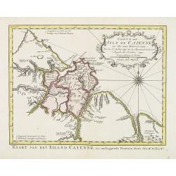
Carte de L'Isle de Caiene et de ses environs.
Uncommon edition of this accurate map of Cayenne. In lower right engraved "31."From Atlas Portatif pour servir a l'intelligence de l'Histoire Philosophique et P...
Place & Date: Amsterdam, 1773
Peru.
Decorated with ships and monsters on the sea. Orientated with east at the top. Shows the Pacific coast of South America from Ecuador (at the left-hand side) as far south ...
- $400 / ≈ €374
Place & Date: Amsterdam, 1658

Tabula Magellanica.
A map with Willem Blaeu's signature, but published by his son Joan, of South America's extremity with the Strait of Magellan and Le Maire Strait.The coastlines are depict...
Place & Date: Amsterdam, 1658
Brasilia.
A mint example of this map is by Krystof Arciszewski, a Polish general who worked for the Dutch West Indian Company. The map perpetuates various myths including the Parim...
- $1250 / ≈ €1170
Place & Date: Amsterdam, 1658
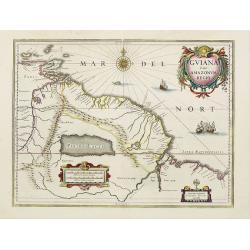
Guiana sive Amazonum Regio.
A very decorative map of Suriname which extends from the Isla Margarita in the northwest to the coast of northern Brazil near Sao Luis east of the Amazon delta. The map l...
- $450 / ≈ €421
Place & Date: Amsterdam, 1658
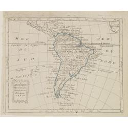
L'Amérique Méridionale, Divisée en ses Principaux Etats.
Map of South America, from Atlas de la Géographie de toutes les parties du monde .. Ouvrage destiné pour l'education, et nécessaire aux négocians, aux voyageurs, aux ...
Place & Date: Paris, Prudhomme, Levrault, Debray, 1806
Amérique Méridionale.
Nice small map of South America. Dated 1748. From Atlas Portatif Universel, by Robert de Vaugondy.Page 105 outside border top right. Mary Sponberg Pedley does not mention...
- $75 / ≈ €70
Place & Date: Paris, later than 1748
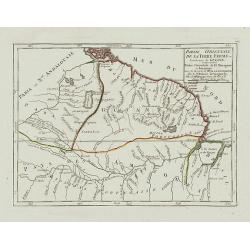
Partie Orientale de la Terre Ferme ou l'on trouve la Guiane.
Nice small map encompassing a large area between the Orinoco and the River Amazon.From Atlas Portatif Universel, by Robert de Vaugondy.Page 107 outside border top right. ...
- $75 / ≈ €70
Place & Date: Paris, later than 1749
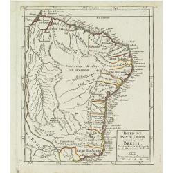
Terre de Sainte Croix, nommée à présent Bresil.
Detailed small map showing most part of the Brazilian seacoasts, from the mouth of the Amazon River as far as the island of Sao Sebastiao.From Atlas Portatif Universel, b...
- $75 / ≈ €70
Place & Date: Paris, later than 1749
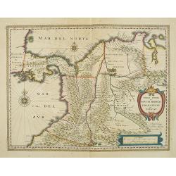
Terra Firma et Novum regnum Granatense et Propayan.
Fine copy, with wide margins of this handsome map of the Isthmus of Panama and northwestern South America including most of present day Columbia and part of Venezuela. Te...
- $400 / ≈ €374
Place & Date: Amsterdam, 1640
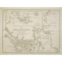
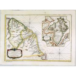
Karte der Magellanischen-Strasse. . .
Very detailed map of Strait of Magellan, with in top inset map of Southern tip of South America with the Falklands. Prepared by Don Juan de La Cruz of Spain.Engraved by J...
- $600 / ≈ €561
Place & Date: Vienna, 1789

Paraguay, Chili, Terre Magellan ?
Map of Paraguay, Chili, and Argentina . By C. F. Delamarche, successor of Robert de Vaugondy, Geographer.
Place & Date: Paris, 1794 -1806
L'Amerique selon l'Etendue de Ses Principales Parties et don't les Points Principaux. . .
Uncommon map of South America, decorated with an elaborate cartouche referring to the conversion of the natives to Christianity, with natives bowing to a figure holding a...
- $600 / ≈ €561
Place & Date: Augsburg, ca. 1790

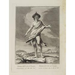
Uomo del Paraguai nell' America Meridionalle. / Homme du Paraguai dans l'Amerique Meridionalle.
Full portrait of a Paraguayan hunter. From "Raccolta di ? stampe." a series of historically significant eighteenth-century copper plate engravings by Venetian e...
- $250 / ≈ €234
Place & Date: Venice, Antonio Zatta, c.1790

Indiana del Perù. / Indienne du Perou.
Portrait of a Peruvian Indian woman holding a fruit basket and a lama in background. From "Raccolta di ? stampe." a series of historically significant eighteent...
- $300 / ≈ €281
Place & Date: Venice, Antonio Zatta, c.1790
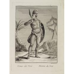
Uomo del Perù. / Homme du Perou.
Full portrait of a Peruvian warrior. From “Raccolta di … stampe.” a series of historically significant eighteenth-century copper plate engravings by Venetian engrav...
Place & Date: Venice, Antonio Zatta, c.1790
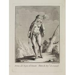
Dona del Regno di Granata. / Femme du Roy.me de Granade.
Full portrait of a woman from Grenada region is situated on Lake Nicaragua. From "Raccolta di ? stampe." a series of historically significant eighteenth-century...
- $250 / ≈ €234
Place & Date: Venice, Antonio Zatta, c.1790
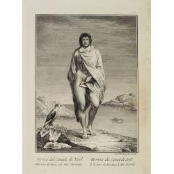
Uomo del Canale di Noël della terra del Fuoco, nel Mar Australe. / Homme du Canal de Noël de la terre de Feu dans la Mer Australe.
Full portrait of a man from the Tierra del Fuego. From "Raccolta di ? stampe." a series of historically significant eighteenth-century copper plate engravings b...
- $250 / ≈ €234
Place & Date: Venice, Antonio Zatta, c.1790
Donna dell' Isola di Pasqua, o terra di Davis nel Mar del Sud. / Femme de l' Isle de Pâques ou terre de Davis dans la Mer du Sud.
Full portrait of a woman, a native of the Easter Island. From "Raccolta di ? stampe." a series of historically significant eighteenth-century copper plate engra...
- $350 / ≈ €328
Place & Date: Venice, Antonio Zatta, c.1790
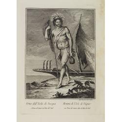
Uomo dell' Isola di Pasqua o Terra di Davis nel Mar del Sud. / Homme de l' Isle de Pâquesou Terra de Davis dans la Mer du Sud.
Full portrait of a native from the Easter Island. From "Raccolta di ? stampe." a series of historically significant eighteenth-century copper plate engravings b...
- $300 / ≈ €281
Place & Date: Venice, Antonio Zatta, c.1790
L'America Meridionale . . .
The second edition of Rossi's map of South America, based upon Sanson's map, but with revised Italian nomenclature. From his 'Mercurio Geografico...'. The engraver was G...
- $900 / ≈ €842
Place & Date: Rome, 1687
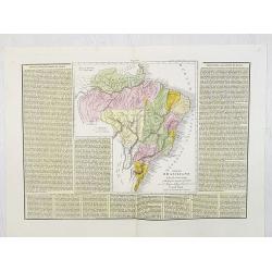
Impero Brasiliano . . .
A rare and detailed double-page map of Brazil. Map is surrounded by an explanatory historical text about the countries in a yellow background color.According to the title...
- $100 / ≈ €94
Place & Date: Venice, 1840
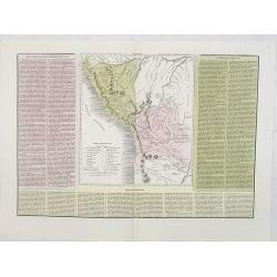
Le due Repubbliche . . . la Confederazione Peruviana . . . Bolivia . . .
A rare and detailed double-page map of Peru and Bolivia. Map is surrounded by an explanatory historical text about the countries in pink, yellow and green background colo...
- $100 / ≈ €94
Place & Date: Venice, 1840
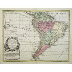
America Meridionalis.
This is the more scarce edition with the title cartouche lower left surrounded by Neptune and a native Indian.A rather accurate depiction and descriptions of South Americ...
- $550 / ≈ €515
Place & Date: Augsburg, c. 1760