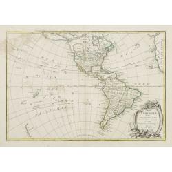
L' Amerique divisée par Grands Etats. . .
Attractive map of America, ornated with a decorative title cartouche. Boundaries outlined in hand color.Prepared by Le Sieur Janvier, Jean denis [Robert], French geograph...
- $450 / ≈ €421
Place & Date: Paris, ca 1783
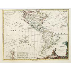
L'America divisa ne suoi principali Stati..
Attractive map of The Americas, with the first voyage of Capt. Cook (1768) depicted around South America and across the Pacific to New Zealand, which is well charted. Nor...
Place & Date: Venice, 1776
Selling price: $500
Sold in 2017
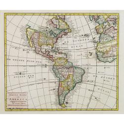
Nieuwe kaart van America.
An attractive map of both the Americas, by one of the leading mapmakers in 18th century Amsterdam. Isaak Tirion (d. 1769) was a Amsterdam publisher. His "Nieuwe en b...
- $400 / ≈ €374
Place & Date: Amsterdam, 1765
Carte du gouvernement de l'Amerique.
A double page sheet including a fine map of America, with California with indented northern coastline (130x92mm.) and New Mexico extending across most of western North Am...
- $300 / ≈ €281
Place & Date: Amsterdam, 1705
![[Printed on silk] Nova Totius Americae Sive Novi Orbis Tabula, Auct. Hugo Allardt.](/uploads/cache/48420-250x250.jpg)
[Printed on silk] Nova Totius Americae Sive Novi Orbis Tabula, Auct. Hugo Allardt.
Hugo Allard’s ca. 1661 map of the Americas, showing California as an island printed on silk. This separately issued map printed on paper is quite rare on the market. T...
Place & Date: Amsterdam, 1661
![Westelijk Halfrond. [Western hemisphere]](/uploads/cache/25524-250x250.jpg)
Westelijk Halfrond. [Western hemisphere]
Uncommon world map view of the western and eastern hemispheres of North and South America, Asia. Lithography by J.H. van Weijer, published in Atlas der geheele Aarde [?] ...
- $50 / ≈ €47
Place & Date: Groningen, ca. 1860

Carte générale de l' Amérique divisée en ses principaux états . . .
Map of North and South America. By C. F. Delamarche, successor of Robert de Vaugondy, Geographer. Descriptive text to the left.
Place & Date: Paris, 1820

Rooseveld rekende verkeerd ! De vangarmen van De Dollarpoliep worden afgesneden. . .
An remarkable Anti-American Dutch World War II propaganda poster by Lou Manche, showing an pink octopus, representing the United States, with its tentacles being cut from...
Place & Date: The Netherlands, 1942

Americae Sive Novi Orbis, Nova Descriptio.
This is the second copperplate of Ortelius' map showing the western hemisphere, showing the prominent bulge in the South American coastline. An important map because of i...
Place & Date: Antwerp, 1579

(Totius Americae nova et exacta tabula ex) optimis tum geographorum tum aliorum scriptis collecta et ad hodiernam regnorum principatuum et maiorum partium distinctionem accomodata.
Eastern part of a two-sheet map of America, with attribution to Willem Blaeu. According to Philip Burden, the map was derived from Cornelius Danckert's 1647 map of the sa...
Place & Date: Rome, 1679

Americae Pars Magis Cognita. Chorographia nobilis & opulentae Peruanae Provinciae, atque Brasiliae, . . . MDXCII
First state. Although a map of South America it does include much of what is now the southern United States. There are two elaborate, strap-work cartouches with the one a...
Place & Date: Frankfurt, 1592

Americae Nova Descriptio.
Final state. According to Philip Burden, "this scarce map is America's first single-sheet map with decorative borders." A re-issue of the 1614 plate by Pieter v...
Place & Date: Amsterdam, 1652

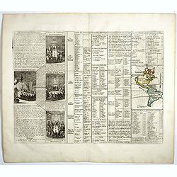
North and South America At-A-Glance.
A clever device for demonstrating the statistics of each country, the Area, Population, Population per Sq. Mile, Highest Elevation, Principal River, Currency, Capital, Fo...
Place & Date: New York & London: International At-A-Glance Chart Co. 1931

Novissima et Accuratissima Totius Americae Descriptio.
Second state of Visscher's map of the Americas, this decorative map greatly influenced the cartography of the Americas both geographically and artistically.Although it di...
Place & Date: Amsterdam, 1677

Carte D'Amerique Divisée en ses Principaux Pays. . .
Rare. Uncommon and decorative wall map of America, prepared by Clouet. With superb decorative borders, 170mm wide at the sides and 150mm at the bottom, containing twenty ...
Place & Date: Paris, Cadiz, 1785

L'Amérique divisée en ses principaux Etats Dressée d'après les Cartes de Mr. Bonne?
Rare, wall map of America in 2 sheets, after R. Bonne. With 3 inset maps of Hispaniola, Martinique and Hudson Bay. Beautiful title cartouche depicting a Native American l...
Place & Date: Paris, 1788