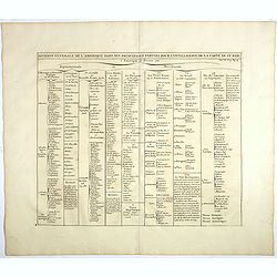
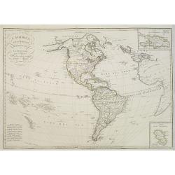
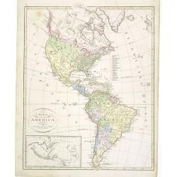
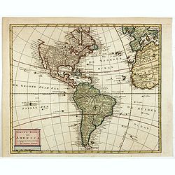
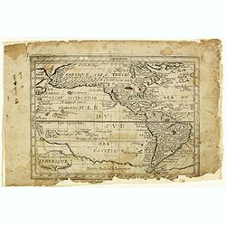
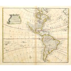
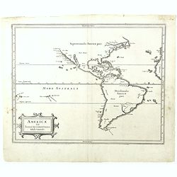
Division generale de l'Amerique dans ses principales parties pour l'intelligence de la carte de ce païs.
This folio sheet gives a breakdown of America into the northern and southern regions. These are further subdivided into the various countries and provinces.Henri Abraham ...
- $25 / ≈ €23
Place & Date: Amsterdam, 1728
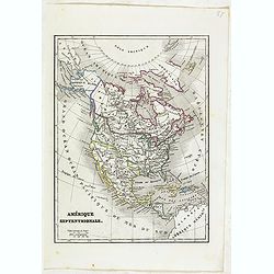
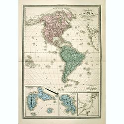
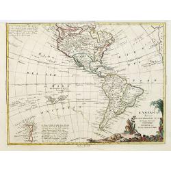
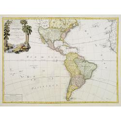
Amérique Septentrionale.
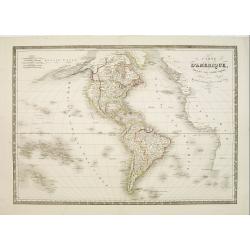
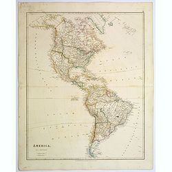
Detailed map of America, prepared by Charles V. Monin (fl.1830-1880) a French cartographer of Caen and Paris. Published in Atlas Universel de Géographie Ancienne &c ...
- $50 / ≈ €47
Place & Date: Paris, 1845
![Westelijk Halfrond. [Western hemisphere]](/uploads/cache/25524-250x250.jpg)
Westelijk Halfrond. [Western hemisphere]
Uncommon world map view of the western and eastern hemispheres of North and South America, Asia. Lithography by J.H. van Weijer, published in Atlas der geheele Aarde [?] ...
- $50 / ≈ €47
Place & Date: Groningen, ca. 1860
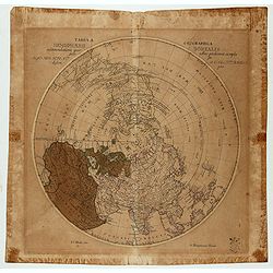
Tabula Geographica Hemisphaerii Borealis…
Polar map with a diameter of 30cm which shows the fictitious Mer de L’Ouest prominently with an extensive river system connecting it with the Great Lakes and thus formi...
- $150 / ≈ €140
Place & Date: Berlin c.1753
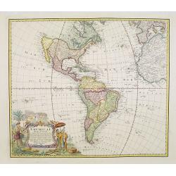
L' Amerique dressée pour l'étude de la géographie . . .
Map showing the American continent. California with a large inlet. Some major cities, bodies of water, and geographic features are marked. There are illustrations of ship...
- $200 / ≈ €187
Place & Date: Paris, 1790
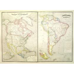
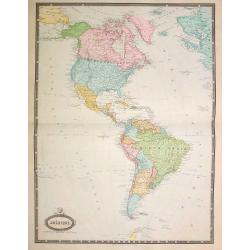
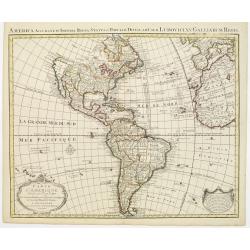
Amérique septentrionale dressée par C.V. Monin. . . / Amérique méridionale. . .
Two maps on one sheet. North America to the left, shows major cities, political divisions, and areas of Indian habitation for North America and the West Indies and state ...
- $300 / ≈ €281
Place & Date: Paris, c.1876
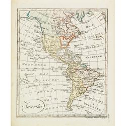
Amerika
Scarce miniature map of the Western Hemisphere.
- $200 / ≈ €187
Place & Date: Augsburg, 1824
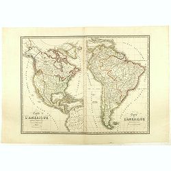
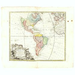
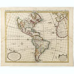
Carte de l'Amerique Septentrionale . . . / Carte de l'Amerique Méridionale . ..
Two maps of America on one sheet, by Nicolas Maire, a French geographer and published by Langlumé et Peltier.
- $250 / ≈ €234
Place & Date: Paris, 1834
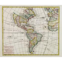
Carte du gouvernement de l'Amerique.
A double page sheet including a fine map of America, with California with indented northern coastline (130x92mm.) and New Mexico extending across most of western North Am...
- $300 / ≈ €281
Place & Date: Amsterdam, 1705
L'America Settentrionale e Meridionale . . .
Map depicting the Americas with two inset maps of the Dominican Republic and Martinique.From Giulio Ferrario's work Le Costume Ancien et Moderne ou Histoire du gouverneme...
- $250 / ≈ €234
Place & Date: Milan, 1827
Carte du gouvernement de l'Amerique.
A double page sheet including a fine map of America, with California with indented northern coastline (130x92mm.) and New Mexico extending across most of western North Am...
- $300 / ≈ €281
Place & Date: Amsterdam, 1705
Amérique..
Very detailed map from Atlas Sphéroïdal & Universel de géographie. Prepared by F.A.Garnier and edited by Jules Renouard, rue de Tournon, Paris. With decorative tit...
- $175 / ≈ €164
Place & Date: Paris, 1861
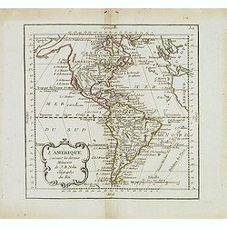
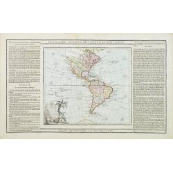
L'Amérique suivant les dernier. . .
Scarce map of America, prepared by Nolin and published by L.J. Mondhare for his Atlas Général a l'usage des colleges et maisons d'education.. Louis Joseph Mondhare was ...
- $200 / ≈ €187
Place & Date: Paris, 1783

Carte générale de l' Amérique divisée en ses principaux états . . .
Map of North and South America. By C. F. Delamarche, successor of Robert de Vaugondy, Geographer. Descriptive text to the left.
Place & Date: Paris, 1820
![[ North and South America with telegraph cables, with Ottoman script]](/uploads/cache/44330-250x250.jpg)
[ North and South America with telegraph cables, with Ottoman script]
Postcard size map showing North and South America with telegraph cables. The map is in Ottoman Arabic-script prepared by Mehmet EŞREF in a small atlas : عمومولا�...
- $190 / ≈ €178
Place & Date: Istanbul, 1325 or 1909
Karta öfver America.
An very rare map of the continent of America with Swedish text. This is an heavenly updated version of his map of 1818 and is now dated 1832.From his atlas "Geograph...
- $300 / ≈ €281
Place & Date: A. Wiborgs förlag, Stockholm, ca. 1848
Carte d'Amerique dressée par Pierre Tardieu. . .
Detailed map prepared by Pierre Tardieu. With good detail on Alaska. Including New Zealand.
- $450 / ≈ €421
Place & Date: Paris, 1831
America.
A very nice map of the American continent with California as an island and an adorned title cartouche.From Francisco Giustiniani for El Atlas abreviado o el nuevo compend...
- $300 / ≈ €281
Place & Date: Leon de Francia (Lyon), Jaime Certa, 1739
Amérique. . .
Very detailed map from Atlas Sphérodidal & Universel de géographie , Prepared by F.A.Garnier and edited by Jules Renouard, rue de Tournon, Paris. With decorative ti...
- $300 / ≈ €281
Place & Date: Paris, 1861
America.
A beautiful, large scale map of the Americas. Alaska is named as 'Russian America', Texas is still a part of Mexico, yet to become a republic (1836), before finally becom...
Place & Date: London, 1839
Nieuwe kaart van America.
An attractive map of both the Americas, by one of the leading mapmakers in 18th century Amsterdam. Isaak Tirion (d. 1769) was a Amsterdam publisher. His "Nieuwe en b...
- $350 / ≈ €328
Place & Date: Amsterdam, 1765
Nieuwe kaart van America.
An attractive map of both the Americas, by one of the leading mapmakers in 18th century Amsterdam. Isaak Tirion (d. 1769) was a Amsterdam publisher. His "Nieuwe en b...
- $400 / ≈ €374
Place & Date: Amsterdam, 1765
L' Amerique divisée par Grands Etats. . .
Attractive map of America, ornated with a decorative title cartouche. Boundaries outlined in hand color.Prepared by Le Sieur Janvier, Jean denis [Robert], French geograph...
- $450 / ≈ €421
Place & Date: Paris, ca 1783
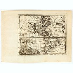
Nouvelle description de lamerique.
Jollain published this rare map of America in 1667. State 3, with the scale, erased, as it fictitious strait on the west coast of North America which Le Royaume de Quiuer...
- $450 / ≈ €421
Place & Date: Paris, 1667
Nouvelle Carte des Amériques Septentrionale et Meridionale avec les Plans des Possessions Françaises en ces Pays, Rédigée et presentée à l'Académie des Sciences. . .
Large, skillfully engraved, and quite scarce map of North and South America, with insets at bottom of Guadeloupe, Martinique, and Plan de Cayenne. In California, the Sier...
- $450 / ≈ €421
Place & Date: Paris, Garnier Fréres, 1832
Americae Mappa generalis Secundum legimitas projectionis Stereiographiae regulas. . . MDCCXXXXVI
Johann Baptist Homann's well-engraved second map of America has a large decorative cartouche. Detailed map of the western hemisphere.The interior of North America has new...
- $600 / ≈ €561
Place & Date: Nuremberg, 1746
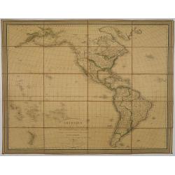
Amérique, réduite d'après celles d'Arrowsmith en 4 flles Par J.N.Champion, Ingénieur-Geographe et . . . Nouvelles découvertes de Clacke et du Major Pike . . .
A charming folding-map of America, drawn by J.N. Champion. The title explains that the map used the latest information by Alexander Humboldt and Clarck and Pike. Dated 18...
- $500 / ≈ €468
Place & Date: Paris, 1815
![Mappa Mondo tagliato sulpiano di unmeridiano Emisfero Occidentale. [togther with] … Orientale.](/uploads/cache/48543-250x250.jpg)
Mappa Mondo tagliato sulpiano di unmeridiano Emisfero Occidentale. [togther with] … Orientale.
World map on two sheets - Western Hemisphere (North and South America, Oceania, Greenland) and Eastern Hemisphere (Europe, Africa, Asia, Australia). Published by Pazzini,...
- $500 / ≈ €468
Place & Date: Siena, 1796

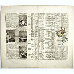
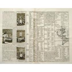
North and South America At-A-Glance.
A clever device for demonstrating the statistics of each country, the Area, Population, Population per Sq. Mile, Highest Elevation, Principal River, Currency, Capital, Fo...
Place & Date: New York & London: International At-A-Glance Chart Co. 1931
A new general map of America drawn from several..
Extremely faint strip of age toning on part of the centerfold, otherwise fine condition. The Pacific Northwest is left open with the note Parts Undiscovered. The coastlin...
- $500 / ≈ €468
Place & Date: London, 1747
L'America divisa ne suoi principali Stati..
Attractive map of The Americas, with the first voyage of Capt. Cook (1768) depicted around South America and across the Pacific to New Zealand, which is well charted. Nor...
Place & Date: Venice, 1776
Selling price: $500
Sold in 2017
![[Columbus is standing in the bow of his ship]](/uploads/cache/48524-250x250.jpg)
[Columbus is standing in the bow of his ship]
Columbus is standing in the bow of his ship, which is near the shore. He is clad in a long mantle and undercoat, while his armor lies at his feet, and his standard is flo...
- $750 / ≈ €702
Place & Date: Frankfurt, 1594
Carte d'Amerique dressée par l'usage du Roy..
Fine map prepared by G.d'Isle depicting North and south America, the west coast taken north to Cap Mendocin and Cap Blanc with a note Entrée decouverte par Martin d'Agui...
Place & Date: Amsterdam, 1739
Americae Mappa generalis.
Johann Baptist Homann's well-engraved second map of America has a large decorative cartouche. Detailed map of the western hemisphere.The interior of North America has new...
- $700 / ≈ €655
Place & Date: Nuremberg, 1746
Americae sive Indiae Occidentalis.
Hessel Gerritsz. the author and probable engraver of the map had seen maps of California as an island, but he relies on the more trustworthy accounts, such as Herrera, in...
- $1000 / ≈ €936
Place & Date: Leiden, 1625
L'Amerique divisée en ses principaux Etats..
Uncommon map published by Lattré. This map is most notable for its depiction of "Mer de L'Ouest" or "Sea of the West". A great sea, easily the size o...
- $900 / ≈ €842
Place & Date: Paris, 1760
Carte d' Amerique Dressee pour l'Usage Du Roy. . .
Detailed copper-engraved map of the American continent. Decorative title cartouche with foliate garland, and embellished lettering of d' Amerique. The western parts of Af...
- $1000 / ≈ €936
Place & Date: Amsterdam c. 1745
Americae Sive Novi Orbis, Nova Descriptio
Woodcut map by based on Abraham Ortelius' classic map of 1570, with the huge bulge in the southwest coastline of South America, the Ortelian western coastline of North Am...
Place & Date: Basel, ca. 1588
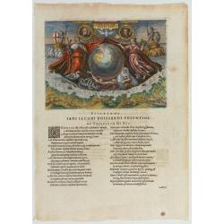
Americae Retectio (Allegory of the Discovery of America)
Allegorical scene commemorating the discovery of America. The main image shows Neptune, supporting a Globe, flanked by Flora-representing Florence, and Janus-representin...
- $1000 / ≈ €936
Place & Date: Frankfurt, 1594
L'Amerique ou le Nouvelle Continent.. Dedieé et presenteé a monseigneur Law.
State one. The map has been prepared by Jean Baptiste Nolin (the elder) has a dedication to Monseigneur LAW controlleur general des finances .Rare general map of the Amer...
- $2200 / ≈ €2059
Place & Date: Paris, 1720