Browse Listings in America > Caribbean & Atlantic Ocean

Nieuwe Wassende Graade Zee Kaart over de Spaanse Zee Vant Kanaal tot 't Eyland Cuba in Westindia. . .
¤ Engraved by I.van Anse. A very representative example of a Dutch chart of the Atlantic, showing the north-east coast of America, the coasts of Africa and Europe and So...
Place & Date: Amsterdam, 1728

Pascaerte vande Vlaemsche, Soute, en Caribesche Eylanden, als mede Terra Nova,. . .
This fine and scarce sea chart covers the central Atlantic and extends to include the Maritime Provinces, Antilles and the northwest coast of South America, east to the A...
Place & Date: Amsterdam, 1672

Pas kaart Van Rio Oronoque Golfo De Paria met d'Eylanden Trinidad, Tabago, Granada, Granadillos, en Bequia . . .
A highly detailed and rare sea chart of the mouth of the Orinoco River, Trinidad, Tabago, St.Vincent and neighboring islands. Oriented with north to the right by two comp...
- $900 / ≈ €842
Place & Date: Amsterdam, 1684
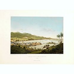
Christianssted. (St.Croix).
A beautiful view of the small town of Christiansted on the island of St. Croix. This view shows much of the harbour and a portion of the town's waterfront. one of a serie...
- $900 / ≈ €842
Place & Date: Copenhagen, Baerentzen & Co, 1856
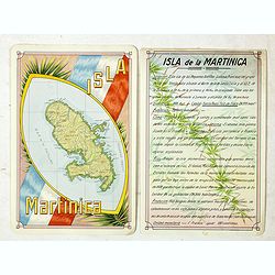
Isla Martinica.
A beautiful hand colored, hand drawn map of the French Caribbean island of Martinique, prepared for the Buenos Aires 1939 Philatelic Exhibition, with separate text with d...
- $100 / ≈ €94
Place & Date: Buenos Aires, 1939
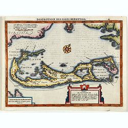
Description des Isles Bermudas.
Map of Bermuda from the rare Cloppenburg edition slightly larger format and more scarce edition of the Mercator/Hondius "Atlas Minor". Engraved by Pieter Van De...
- $800 / ≈ €749
Place & Date: Amsterdam, 1630
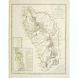
Carte de la Dominique Prise par les Francois le 7 Septembre 1778. Avec le Plan du Debarquement et de l'Attaque des Forts et Batteries par les Troupes et Les Fregates de sa Majeste
A rare map of St. Dominica, with insets of Charlotteville with its attack by the French on 7 September 1778 on the British. Also small inset map of the Caribbean islands ...
- $500 / ≈ €468
Place & Date: Paris, 1778
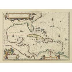
Insulae Americanae in Oceano Septentrionali cum Terris adiacentibus.
General map of the West Indies extending from Virginia to the mouth of the Orinoco, and destined to be copied in various shapes by many other publishers.Title cartouche t...
- $1800 / ≈ €1684
Place & Date: Amsterdam, 1638
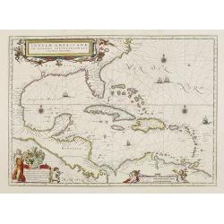
Insulae Americanae in Oceano Septentrionali cum Terris adiacentibus.
General map of the West Indies extending from Virginia to the mouth of the Orinoco, and destined to be copied in various shapes by many other publishers. Title cartouche ...
- $1500 / ≈ €1404
Place & Date: Amsterdam, 1658
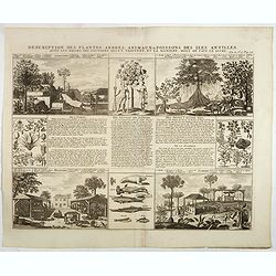
Description des plantes, arbres, animaux & poissons des Antilles . . .
Interesting sheet with eight detailed views illustrating fauna and flora on the Antillean islands, and how the natives are making sugar, with descriptive French text, fro...
- $150 / ≈ €140
Place & Date: Amsterdam, 1728