Search Listings matching "hondius" in America
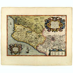
Hispaniae novae sive magnae recens et vera descriptio. 1579
This was the standard map of the area for a generation, copied by De Bry, Quad and Hondius. Even though Herrera (Spain's Royal Cosmographer) and Wytfliet worked 20 years ...
Place & Date: Antwerp, 1598
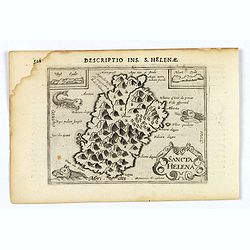
Sancta Helena.
An attractive small map of the south Atlantic island of St. Helena. Two years after the publication of Linschoten's Itinerario, the first map of St. Helena appeared in 15...
- $100 / ≈ €85
Place & Date: Amsterdam, 1606
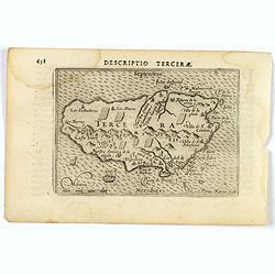
Descriptio Tercerae.
An attractive miniature map of The Azorian island of Terceira, in the Atlantic Ocean. Published by Petrus Bertius, in Amsterdam at the turn of the seventeenth century. Di...
- $100 / ≈ €85
Place & Date: Amsterdam, 1606
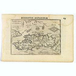
Decriptio Hispaniolae.
A miniature map of Hispaniola, (modern day Haiti and Dominican Republic), as well as the extreme eastern parts of Cuba. With a simple strap-work title and a scale in Germ...
- $150 / ≈ €128
Place & Date: Amsterdam, 1606
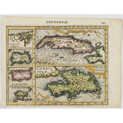
Cuba Insula. Hispaniola.
Decorative engraved map of Cuba above Hispaniola with smaller insets of Havana, Jamaica, Puerto Rico and Margarita.From the first French-text edition of Jodocus Hondius''...
- $300 / ≈ €256
Place & Date: Amsterdam, 1608

Polus Arcticus cum vicinis regionibus.
Map of the North Pole regions from the 1608 second edition of Jodocus Hondius' Atlas Minor.A reduction of the 1606 Mercator-Hondius folio map (which is a later state of t...
Place & Date: Amsterdam, 1608
Hispania Nova.
The rare Samuel Purchas' edition of the Mercator/Hondius Atlas Minor atlas map. This was the standard map of the area for a generation. The map shows an area correspondin...
- $100 / ≈ €85
Place & Date: London, 1625
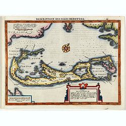
Description des Isles Bermudas.
Map of Bermuda from the rare Cloppenburg edition slightly larger format and more scarce edition of the Mercator/Hondius "Atlas Minor". Engraved by Pieter Van De...
- $800 / ≈ €684
Place & Date: Amsterdam, 1630
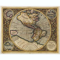
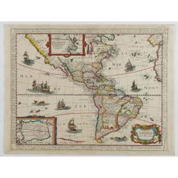
America sive India Nova.
This map was created by Michael Mercator, grandson of the great Gerard Mercator. It is the only map attributed to him. The map first appeared in 1595, one year after the ...
- $3000 / ≈ €2565
Place & Date: Amsterdam, 1630
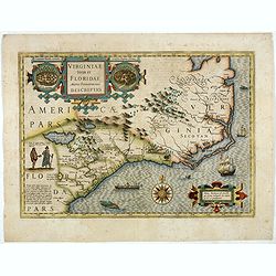
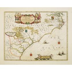
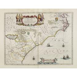
Virginiae item et Floridae. . .
Cummings describes it as one of the most beautifully executed maps ever made of the Southeast. In detail and in general conception it surpasses all earlier maps of the re...
- $2200 / ≈ €1881
Place & Date: Amsterdam, 1630
Virginiae item et Floridae . . .
Map of Virginia from the rare Cloppenburg edition slightly larger format and more scarce edition of the Mercator/Hondius "Atlas Minor". Engraved by Pieter Van D...
- $750 / ≈ €641
Place & Date: Amsterdam, 1630

Paraguay o Prov. de Rio de la Plata cum regionibus adiacentibus Tucuman et Sta. Cruz de la Sierra.
Blaeu's map of the Rio de la Plata region of South America. Originally engraved for Jodocus Hondius II, at his death in August 1629 this map was, among 39 other copper pl...
Place & Date: Amsterdam, 1634
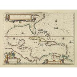
Insulae Americanae in Oceano Septentrionali cum Terris adiacentibus.
General map of the West Indies extending from Virginia to the mouth of the Orinoco, and destined to be copied in various shapes by many other publishers.Title cartouche t...
- $1800 / ≈ €1539
Place & Date: Amsterdam, 1638
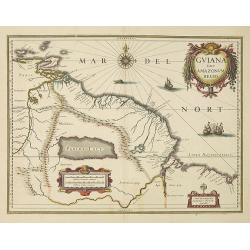
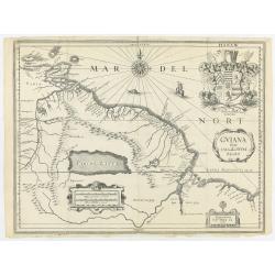
Guiana sive Amazonum Regio.
Willem Blaeu’s decorative map of the Guianas, Lake Parima (Parime Lacus), and the route to El Dorado was initially issued in 1630 (with some variants were published wel...
- $400 / ≈ €342
Place & Date: Amsterdam, 1638

Virginiae Partis Australis, et Floridae Partis Orientalis.
Blaeu based this map on the Mercator-Hondius of 1606. A number of geographical improvements, however were incorporated, although two large fictions lakes accompanied by e...
Place & Date: Amsterdam, 1640
Virginiae Partis Australis, et Floridae Partis Orientalis.
Blaeu based this map on the Mercator-Hondius of 1606. A number of geographical improvements, however were incorporated, although two large fictions lakes accompanied by e...
- $1400 / ≈ €1197
Place & Date: Amsterdam, 1640

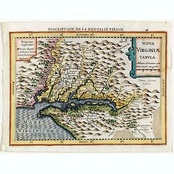
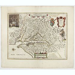
Nova Virginiae Tabula.
A fine example of Blaeu's map of Virginia and the Chesapeake region is based on the first state of Smith's map, 1612, and is slightly larger and more expertly engraved.Th...
Place & Date: Amsterdam, 1640
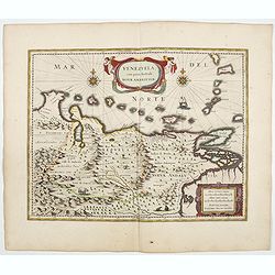
Venezuela cum parte Australi Novae Andalusiae.
A finely engraved, decorative map of Venezuela. The islands of Trinidad and Tobago, Margarita, Aruba and Curaçao are shown. Local animals are depicted, sheep, birds, mon...
- $800 / ≈ €684
Place & Date: Amsterdam, ca. 1644
Nova Virginiae Tabula.
The map is based on the first state of Smith's map, 1612, and is slightly larger and more expertly engraved. In 1629 the Hondius plate was purchased by Blaeu who deleted ...
Place & Date: Amsterdam, 1644
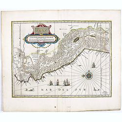
Peru.
FIRST EDITION, FIRST ISSUE OF THIS MAP. Decorated with ships and monsters in the sea. Orientated with east at the top. With the signature of G. Blaeuw lower right corner....
- $900 / ≈ €769
Place & Date: Amsterdam, 1644
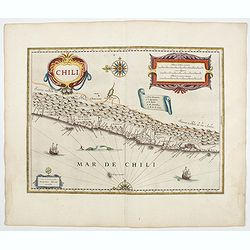
Chili.
Willem Blaeu's very decorative map of Chili with two large and beautiful cartouches, a compass and ships. From early on Willem Jansz. Blaeu aimed of publishing an atlas ...
- $900 / ≈ €769
Place & Date: Amsterdam, 1644
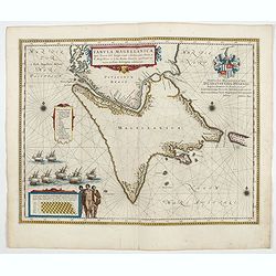
Tabula Magellanica.
A map with Willem Blaeu's signature, but published by his son Joan, of South America's extremity. A dedication to Constantijn Huygens. From early on Willem Jansz. Blaeu ...
- $1000 / ≈ €855
Place & Date: Amsterdam, 1644
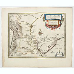
Paraguayo prov. de Rio de La Plata cum regionibus..
A beautiful map of Paraguay, and parts of Peru, Chile, Argentina, Brazil and Bolivia. Much of the area was still "Terra Incognita" so there are few towns and ci...
- $600 / ≈ €513
Place & Date: Amsterdam, 1644
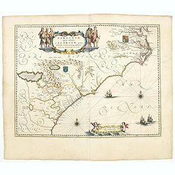
Virginiae Partis Australis, et Floridae Partis Orientalis.
Blaeu based this map on the Mercator-Hondius of 1606. A number of geographical improvements, however were incorporated, although two large fictions lakes accompanied by e...
- $1500 / ≈ €1282
Place & Date: Amsterdam, 1644
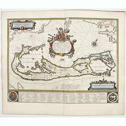
Mappa Aestivarum Insularum alias Barmudas.
Blaeu based his work on John Speed's remarkably accurate map of 1626-1627. It shows the island divided into tribes and lots, and below the map itself appear the names of ...
- $2000 / ≈ €1710
Place & Date: Amsterdam, 1644
Virginiae Partis Australis, et Floridae Partis Orientalis.
Blaeu based this map on the Mercator-Hondius of 1606. A number of geographical improvements, however were incorporated, although two large fictions lakes accompanied by e...
Place & Date: Amsterdam, 1658
Carte de L'AMERIQUE Corrigeé et argumenteé….
Separately published map published in 1658 but based on Petrus Bertius map of 1624., this on its turn taken from Jodocus Hondius map of 1618. On the sides he lists the pr...
Place & Date: Paris, 1658

Nova Virginiae tabula.
A fine example of Blaeu's map of Virginia and the Chesapeake region is based on the first state of Smith's map, 1612, and is slightly larger and more expertly engraved.Th...
Place & Date: Amsterdam, 1635/1660

Poli Arctici, et circumiacentium terrarum descriptio novissima. . .
A re-issue of the Hondius' plate. A particularly decorative map of the North Pole with Iceland. Several Dutch names in Labrador. The toponymy in Canada reflects the conti...
Place & Date: Amsterdam, 1660
Guiana sive Amazonum regio.
This very rare map shows northwest Latin America with Surinam and French Guiana and was engraved by Johann Philipp Thelott. The map comes from the work of Johann Joachim ...
Place & Date: Frankfurt, 1669

Nova Virginia Tabula.
A beautifully engraved map, derived from the highly influential map by Captain John Smith in 1612, showing Chesapeake Bay and the surrounding area. The decoration of this...
Place & Date: Amsterdam, J.Meurs, 1671