Browse Listings in Africa > North Africa
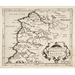
Marocchi Regnum.
From the Mercator/Hondius Atlas Minor. Early map of Morocco.
Place & Date: Amsterdam, 1645
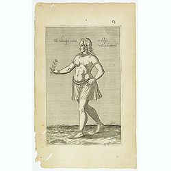
Fille Moresque esclave en Alger ville de Barbarie. (63)
Sought-after copper engraved plate of a young slave from Algeria. Plate from Laonikos Chalcocondyle’s "L'histoire de la décadence de l'empire grec et establisseme...
- $45 / ≈ €42
Place & Date: Paris, Mathieu Guillemot, 1650
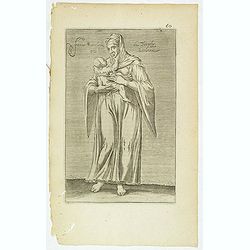
Femme moresque de Tripoly en Barbarie. (60)
Sought-after copper engraved plate of a woman with child from Tripoli. Plate from Laonikos Chalcocondyle’s "L'histoire de la décadence de l'empire grec et establi...
- $45 / ≈ €42
Place & Date: Paris, Mathieu Guillemot, 1650
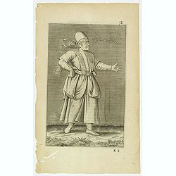
Esclave More. (38)
Sought-after copper engraved plate of a Moor slave from North Africa. Plate from Laonikos Chalcocondyle’s "L'histoire de la décadence de l'empire grec et establis...
- $75 / ≈ €70
Place & Date: Paris, Mathieu Guillemot, 1650

Insulae de Cabo Verde olim Hesperides sive .. Zoute Eylanden.
Original copper engraving, hand colored in outline, when published. Double page chart covering detailed the Cap Verde Islands in the Atlantic Ocean (Isla de San Antonia, ...
Place & Date: Amsterdam, 1655

Original copperplate.
Showing the coast of southern Morocco, the Sahara with the Canary Islands. Copperplates that had been used in the production of early maps are of the greatest rarity and ...
Place & Date: Amsterdam, ca. 1660

De Cust van Barbaryen van out Mamora tot Capo Blanco..
Six charts on one sheet. The two upper charts covering an area from Cape Blanc to Casablanca. In lower part four insets with detailed charts of islands as Madera, Porto S...
Place & Date: Amsterdam, 1666

De Cust van Barbaria, Gualata, Arguyn, en Gene..heo, van Capo S.Vincente tot Capo Verde.
An eye-catching chart of the north western coast of Africa. Including Canary Islands, Cape Verde Islands and Azores.Pieter Goos (ca. 1616-1675) was one of the most import...
Place & Date: Amsterdam, 1666

.Caarte voor een gedeelte der Canarise Eylanden als Canaria, Tenerifa, Forteventura, etc.
Very rare chart of the Canaries. Showing Palma, Ferro, Tenerife, Gran Canaria, Forteventura, Lancerota. In upper right hand corner inset of harbour of Lancerota.
- $1000 / ≈ €936
Place & Date: Amsterdam, 1666
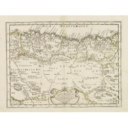
Partie de la Barbarie ou est le royaume d'Alger. . .
Coastal map of North Africa prepared by N.Sanson and published by Pierre Mariette.Published in an early edition of the small Sanson atlas L'Europe Dediée a Monseigneur ....
- $80 / ≈ €75
Place & Date: Paris, P. Mariette, 1667