Browse Listings in Africa > Central Africa

Pas-Kaat vaneen gedeelte van de Aethiopische Zee behelsende de Kusten Zanguebar, Ajan en Abex, en een gedeelte van de Arabische Kust. . .
A finely engraved and detailed chart of the most eastern tip of Africa, including Somalia, Djibouti, Yemen, Mauritius, and many other islands in the Indian Ocean.Very rar...
Place & Date: Amsterdam, 1753
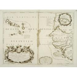
Bocche del Fiume Negro et Isole di Capo Verde.
Double-page engraved map of the Cape Verde Islands and part of the coast of Senegal, with large decorative cartouche. One with inset of the island Goree. During three cen...
Place & Date: Venice, 1690

Tractus Littorales Guineae a Promontorio Verde usque ad sinum Catenbelae.
Chart of the West coast of Africa from Mauritania up to Angola. In top centre a very decorative title cartouche.
Place & Date: Amsterdam, 1675
![[West Africa]](/uploads/cache/46529-250x250.jpg)
[West Africa]
Second block. West Africa, from the Tropic of Cancer south to St Thomas. The interior is filled with lions, elephants, monkeys and camels, with a fenced native village. O...
Place & Date: Venice, 1563

.Tabu nova partis Aphri.
Based on Waldseemüller's map. The maps show Northern Africa as it was known to Europeans at the first part of the 16th century. There is great details across north Afric...
Place & Date: Lyons, M. Servetus, 1535

Carta particolare che comincia con il c.apo Aldea è Finisce con il capo Degortam. . .
Dudley’s magnificent chart shows the south west coast of Africa. A first edition without the privilege..Engraved by Lucini.Sir Robert Dudley's Dell'Arcano del Mare is t...
- $1250 / ≈ €1170
Place & Date: Florence, 1645
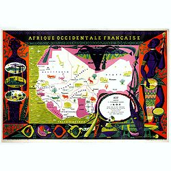
Afrique Occidentale Française AOF.
Beautiful and decorative lithograph pictorial map of Equatorial Africa, showing animals in a beautiful design… Made for Agence de la France d'Outre-Mer. The artist Alai...
- $1100 / ≈ €1029
Place & Date: Imprimerie Raidot, Paris, ca. 1950

Paskaart van Guinea van C.Verde tot R. deGalion.
Rare edition of Doncker's sea chart of Guinea coast. From an atlas printed in 1668, "l'Atlas de MER ou MONDE AQUATIQUE, Remontrant toutes lescôtes de la Mer…"...
- $1000 / ≈ €936
Place & Date: Amsterdam, 1660-1668
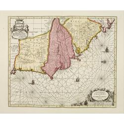
Genehoa Jaloffi et Sierraliones regna.
Decorative and detailed map of the West African Coast, from Senegal to Sierra Leone. In the center the river Gambia to the mouth in the Atlantic. Upper left a dedication ...
Place & Date: Amsterdam, 1670 / 1720

Carte Particuliere d'une Partie d'Asie ou sont Les Isles D'Andemaon, Ceylan, Les Madives . . .
An impressive large sheet chart including the Red Sea, the coasts of Somali, Yemen, east coast of the Arabian peninsula. One of the early maps to focus on this area. Nume...
- $1000 / ≈ €936
Place & Date: Amsterdam, 1720