Browse Listings in Africa > Central Africa
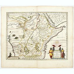
Aethiopia Superior vel Interior vulgo Abissinorum.
An attractive map of the Eastern African and the fictitious kingdom of Prester John. The map shows a major section of central and eastern Africa including Mozambique nort...
- $900 / ≈ €842
Place & Date: Amsterdam, 1644
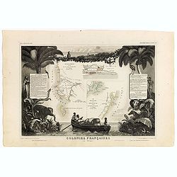
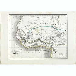
Colonies Françaises (en Afrique). N°91.
Handsome map divided into two sections shows a section of the coast of French West Africa titled 'Senegambie' (Senegal & Gambia) with a drawing of the Senegal River a...
Place & Date: Paris, A. Combette, 1852
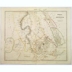
Nubia & Abyssinia.
A lovely looking steel engraved map of the portion of Africa that lies to the west of the Red sea. Mostly great deserts and the territories of nomadic African tribes are ...
Place & Date: London, 1839
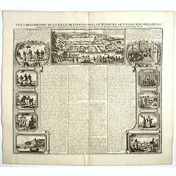
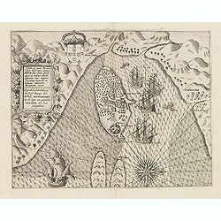
Vue et description de la Ville de Lovango dans le Royaume du Congo. . .
On top a large view of the fabled city of Lovango, text surrounded by ten vignettes of the people and ceremonies of the Kingdom of Congo.Zacharie Chatelain (d.1723) was t...
Place & Date: Amsterdam, 1720
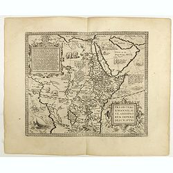
Presbiteri Johannis, sive Abissinorum Imperii descriptio.
Depicting Africa from the Mediterranean to the Mountains of the Moon placed just below Mozambique. Dare to go in Black. All early maps were printed in black and white,...
Place & Date: Antwerp, 1598

Pas-Caart van Guinea en den Custen daer aen gelegen Van C..
A decorative chart of the southwest coast of Africa, embellished with an elaborate, finely colored title-cartouche, and 2 compass-roses. Pieter Goos (ca. 1616-1675) was o...
Place & Date: Amsterdam, 1666
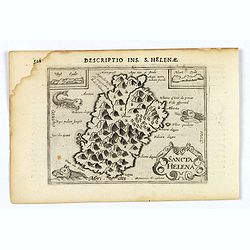
Sancta Helena.
An attractive small map of the south Atlantic island of St. Helena. Two years after the publication of Linschoten's Itinerario, the first map of St. Helena appeared in 15...
- $100 / ≈ €94
Place & Date: Amsterdam, 1606
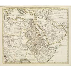
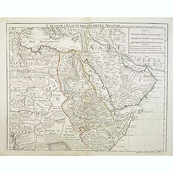
Carte de l'Egypte de la Nubie de L'Abissinie &c..
Detailed copper-engraved map of North-East Africa showing Guinea in the southwest through Ethiopia , the Red Sea to the Persian Gulf.In the northwest, Tunis through Egypt...
- $500 / ≈ €468
Place & Date: Amsterdam, c. 1745
![[2 sheets] Carte particuliere de la Cote Occidentale de l'Afrique...](/uploads/cache/42917-250x250.jpg)
[2 sheets] Carte particuliere de la Cote Occidentale de l'Afrique...
A large 2 sheet map of a part of the west coast of Africa that covers The Gambia and Senegal. (When joined the map would measure approx. 1010 x 1400 mm) D'anville's maps ...
- $400 / ≈ €374
Place & Date: Paris, ca. 1751
Congi regnu.
Samuel Purchas' edition of the Mercator/Hondius Atlas Minor . Early map of Congo published in his famous collection of voyages His Pilgrimes . With descriptive text in En...
- $100 / ≈ €94
Place & Date: London, 1645

Carte Particuliere d'une Partie d'Asie ou sont Les Isles D'Andemaon, Ceylan, Les Madives . . .
An impressive large sheet chart including the Red Sea, the coasts of Somali, Yemen, east coast of the Arabian peninsula. One of the early maps to focus on this area. Nume...
- $1000 / ≈ €936
Place & Date: Amsterdam, 1720
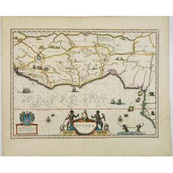
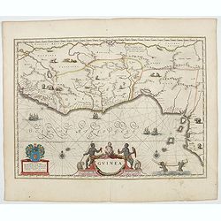
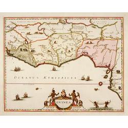
Guinea.
An attractive map covered with intersecting rhumb lines and decorated with monkeys, lions, elephants and native figures. With a dedication to Dr. Nicolas Tulp.
- $750 / ≈ €702
Place & Date: Amsterdam, 1640
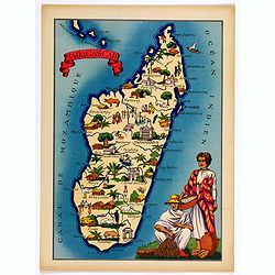
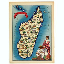
Madagascar.
Very decorative, informative map of Madagascar. The map is filled with buildings, animals, figures and two locals in their typical dress.In lower left corner "Imprim...
- $90 / ≈ €84
Place & Date: France, 1943
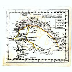
Map of Senegal with part of the coast of Africa.
Uncommon miniature map of Senegal with part of the coast of Africa, engraved by Thomas Kitching for "A New General and Universal Atlas Containing Forty five Maps by ...
- $40 / ≈ €37
Place & Date: London, 1761-1763
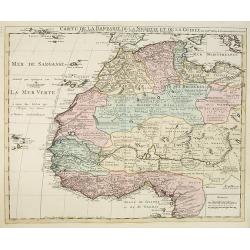
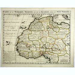
Carte de la Barbarie de la Nigritie et de la Guinée..
Richly engraved map of North and West Africa, based upon the earlier maps of De L'Isle. Richly annotated throughout and with excellent regional detail. It includes the Ca...
- $350 / ≈ €328
Place & Date: Amsterdam c. 1745
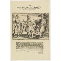
XX. Repraesentatio Eorum Quae Praeterea in Cabo Lopo Gonfalues. . . (More inhabitants of Cabo Lopo Gonsalues)
Here we see more figures of Cabo Lopo Gonsalues and Rio de Gabon. A: a distinguished man decked out in his finery and carrying several types of knives in his belt. In his...
- $100 / ≈ €94
Place & Date: Frankfurt, 1609
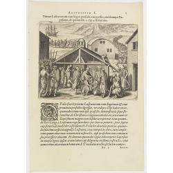
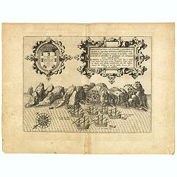
Argumentum I. Primus Lufitanorum cum Sogni praefecto congreffus, eiusdemque Baptismus, de quibus lib. 2 cap 2. fit mentio. (The arrival of the Portuguese in the county Sogno)
The arrival of the Portuguese in the county Sogno. When the Portuguese first discovered the county and the inhabitants of Sogno, they were taken for gods and received wit...
- $100 / ≈ €94
Place & Date: Frankfurt, 1598
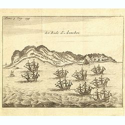
La rade d'Annobon.
Fine print of the arrival of the Dutch fleet by Cornelis Matelief de Jonge at Annobon, September 7th 1605. Cornelis Matelief de Jonge made a trip for the V.O.C. to the Ea...
- $100 / ≈ €94
Place & Date: Amsterdam, J.F. Bernard, 1725
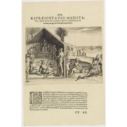
XIX. Repraesentatio Maiestatis, qua rex in Cabo Lopo Gonsalves . . . (How the chief of Cabo Lopo Gonsalues presents himself )
This describes the places they call Cabo Lopo Gonsalues and Rio de Gabon, where the chief receives his visitors. He sits on a chair placed upon a platform with two or thr...
- $100 / ≈ €94
Place & Date: Frankfurt, 1609
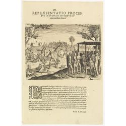
VII. Repraesentatio Processus in Iudiciis Civilibus et Criminalibus Ufitati. (Courts and Administration of Justice)
A depiction of the court and administration of justice. Seven features are identified : (A) the king or chief listening to a case presented to him, (B) the beheading of a...
- $90 / ≈ €84
Place & Date: Frankfurt, 1609
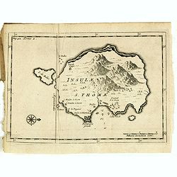
Insulae S. Thomae.
Uncommon map of the Island of St. Thomas located in the Atlantic Ocean near West Africa. From the French reissue of the account of early Dutch voyages first published in ...
- $75 / ≈ €70
Place & Date: Amsterdam, F. Bernard, 1725
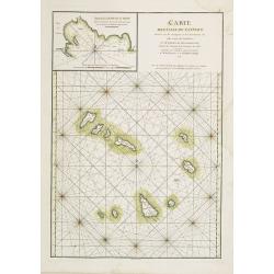
Carte des Iles du Cap-Verd Dressée sur les remarques et les observations les plus exactes des Navigateurs.
French sea chart of the Cap Verde Islands, situated 570 kilometers off the coast of Western Africa.Latitude and longitude scales, compass rose and system of rhumb lines, ...
- $100 / ≈ €94
Place & Date: Paris, Brest, chez Demonville, 1775
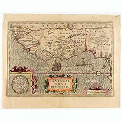
Guineae Nova Descriptio.
The map shows the West African coast from Senegal (the 'Rio Senega' is the Senegal River) to Cape Lopez on the Gulf of Guinea just below the equator.The island of St. Tho...
- $700 / ≈ €655
Place & Date: Amsterdam, 1628
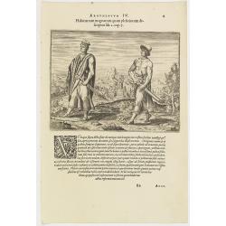
Argumentum IV. Habitus tam magnatum quam plebeiorum descriptus lib. 2 cap. 7. (How the Congolese men dress)
This shows what the inhabitants of the Congo wore before the Portuguese arrived. The men had small square berets, usually red or yellow, more for decoration than as prote...
- $100 / ≈ €94
Place & Date: Frankfurt, 1598
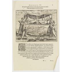
Argumentum VI. De modis quibus de loco in locum, feruorum aut conductitiorum humeris transferri Folent. (How the Congolese are transported)
How the Congolese are transported. None of the horses (probably zebras) are tame enough to ride and the people seem incapable of training the oxen to pull wagons for the ...
- $100 / ≈ €94
Place & Date: Frankfurt, 1598
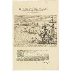
VIII. Repraesentatio Commerciorum et Negotiationum, Quas Nigritae cum Batauis exercent.
Locals from Gold Coast trying to sell items to the crew of a Dutch vessel. Theodore de Bry, a German engraver and book dealer, began a compilation of early voyages in 159...
- $100 / ≈ €94
Place & Date: Frankfurt, 1609
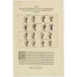
XXVI. Repraesentatio Capitum Praecipuarum Aliquot Personarum in Benyn.
Different types from Benin, in West Africa.Theodore de Bry, a German engraver and book dealer, began a compilation of early voyages in 1590 and had published six parts at...
- $75 / ≈ €70
Place & Date: Frankfurt, 1609
Sénégambie et Guinée.
Detailed map of the western part of Africa, prepared by Charles V. Monin (fl.1830-1880) a French cartographer of Caen and Paris. Published in Atlas Universel de Géograph...
- $45 / ≈ €42
Place & Date: Paris, 1845

Carta particolare che comincia con il c.apo Aldea è Finisce con il capo Degortam. . .
Dudley’s magnificent chart shows the south west coast of Africa. A first edition without the privilege..Engraved by Lucini.Sir Robert Dudley's Dell'Arcano del Mare is t...
- $1250 / ≈ €1170
Place & Date: Florence, 1645
Insulae et arcis Mocambique descriptio ad fines Melinde sita ebano puriss.
Attractive bird's-eye view of Melinde harbor in Mozambique showing the fortifications with numerous ships at anchor in the protected harbor. The map is finely engraved an...
- $300 / ≈ €281
Place & Date: Frankfurt, 1607
Carte de l'Egypte de la Nubie de l'Abissinie..
Map of east Africa showing South Arabia.
- $200 / ≈ €187
Place & Date: Paris, 1780
![[Lot of 3 maps] Le Coste Dell' Alta Guinea… [with] Carta del Basso Egitto [with] Le Coste di Barbaria.](/uploads/cache/48545-250x250.jpg)
[Lot of 3 maps] Le Coste Dell' Alta Guinea… [with] Carta del Basso Egitto [with] Le Coste di Barbaria.
A lot of three maps of nort and eastern Africa. Published by Pazzini, Carli (1707-1769) and prepared by Bartolomeo Borghi (1750-1821). Features decorative title cartouche...
- $300 / ≈ €281
Place & Date: Siena, 1796
Madagascar.
Very decorative, informative map of Madagascar. The map is filled with buildings, animals, figures and two locals in their typical dress.In lower left corner "Imprim...
- $90 / ≈ €84
Place & Date: France, 1943
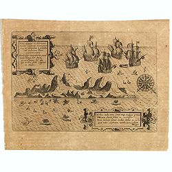
Vera effigies et delineatio Infulce Ascenstio. . . (St. Helena)
Striking view of the Island of Ascuncion (St. Helena).Theodore de Bry, a German engraver and book dealer, began a compilation of early voyages in 1590 and had published s...
- $100 / ≈ €94
Place & Date: Frankfurt, 1609
Carte de la barbarie, Nigritie et de la Guinée avec les pays voisins . . .
This great map of western Africa is based on Guillaume Delisle's map. It covers from the Barbary coast to below the equator. There is a mass of geographic detail and nota...
- $300 / ≈ €281
Place & Date: Amsterdam, 1720
Guinea.
An attractive map covered with intersecting rhumb lines and decorated with monkeys, lions, elephants and native figures. With a dedication to Amsterdam anatomist and phys...
- $750 / ≈ €702
Place & Date: Amsterdam, 1644
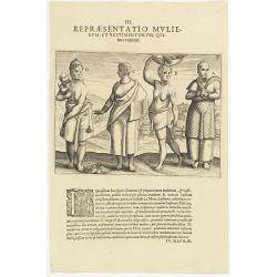
III. Repraesentatio Mullierum, et vestimentorum, Quibus Utuntur.
Inhabitants of the coast of the Ivory coast in Africa.Theodore de Bry, a German engraver and book dealer, began a compilation of early voyages in 1590 and had published s...
- $75 / ≈ €70
Place & Date: Frankfurt, 1609
Guinea.
A close copy of the map by Blaeu. Covers the Guinea and Benin coast. A very decorative map with a large title cartouche. At bottom right two putti area carrying an elepha...
- $1100 / ≈ €1029
Place & Date: Amsterdam, 1680
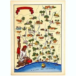
Cote d'Ivoire.
Very decorative, informative map of the Ivory coast. The map is filled with buildings, animals, a ship, figures and two locals in their typical dress.In lower left corner...
- $90 / ≈ €84
Place & Date: France, 1943
Insula D.Helenae sacra coeli Clementia . . .
A fine perspective view of the Island of St.Helena in the South Atlantic. The location of the Island directly on the navigation route from Europe to the Cape of Good Hope...
- $750 / ≈ €702
Place & Date: Frankfurt, 1609